
Home Preamble Index Areas Hills Lakes Dales Places References Me
Saunterings is a set of reflections based upon walks around the counties of
Cumbria, Lancashire and
North Yorkshire in North-West England (as defined in the
Preamble).
This webpage gives some notes of North-West England outings before those described in
Saunterings, which was started in 2018. I've included only
those for which I have evidence that would stand up in a court of law (diary
entries, photographs, and so on). I haven't included repetitions of very similar outings.
The outings were walks or
runs – the longer ago it was the more likely it was a run. I never
took a camera on a run, and quite often not on a walk either, especially in the early
days, so photographic enlightenment becomes a little sparse.
[After each one I have (if possible) added a link to a more recent Sauntering in the region.]
-1. Around the Windmills of Caton Moor
On December 31 2017 I had my last run. I had resolved in December 2016 to run every day
in 2017, and then stop, before starting Saunterings. I wanted to end my running
with a bang, rather than let it just wither away. So on my last run, I ran around my
old friends, the Caton windmills. I will not list the other 364 runs (sigh of relief). Since
I ran every day, I didn't have much energy left for walks in 2017 but occasionally some
friends insisted.
December 2017; SD5464; Brookhouse - E, Quarry Road - Caton Moor Wind Farm - S, W, N, W,
Quarry Road - Brookhouse; 6 miles.
[Are the Caton Windmills on their Last Legs?]
-2. Roeburndale's Hornby Road
It's a track really - described as "the finest moorland track in
the north of England" (by whom I don't know).
September 2017; SD5965; above Backsbottom
Farm - S - Lower Salter - SE - High Salter Close - and back; 8 miles.
[The Long and Winding Hornby Road]
 -3. The Eastern Slopes of Bannisdale
Right: Bannisdale from Capplefall.
August 2017; NY5401; near Bannisdale
Low Bridge - E - Dryhowe Bridge - N - The Forest - SE - Cappelfall, near Bannisdale Low Bridge; 5 miles.
-4. Around Crook
Actually, this was two short runs, on two days, from a
soggy campsite.
August 2017; SD4795; Pound
Farm - W - Crook - NW - Waingap - NE, E, S, Crook Road - E - Pound Farm - S, Cappelrigg
Lane - S, W, N - Lindreth Brow - NE, W - Pound Farm; 8 miles.
-5. Malham Cove and Gordale Bridge
We went hoping to see the peregrines.
We arrived to find the car-park full and the adjoining
field filling fast. I assumed that there was some event on but the stewards said that it was
like this every summer weekend. The poor residents of Malham - but then they have this
spectacular scenery every day whereas most visitors have somewhere like Leeds or Bradford
every day. We didn't see the peregrines.
April 2017; SD9062; Malham - N - Malham
Cove - SE - Gordale Bridge - SW - Mires Barn - N - Malham; 4.5 miles.
-6. By Langden Brook
We went hoping to see a hen harrier. We
didn't, and neither did most people in Bowland in 2017. No hen harriers nested in 2017 in
Bowland, although the region was, a few years ago, the stronghold for hen harriers in England.
April 2017; SD6351; south of
Sykes Farm - W - Langden Castle - and back; 4 miles.
[At the Heart of Bowland: Langdendale, Bleadale and Haredendale]
 -7. Great Mell Fell
This was a short walk up the not-very-high
Great Mell Fell (537m) after riding/running around the Troutbeck Head campsite in the morning.
Right: Clough Head and Blencathra from Great Mell Fell.
April 2017; NY4024; near Brownrigg Farm - E, N - Great
Mell Fell - and back; 4 miles.
-8. From Troutbeck to Ambleside
A Boxing Day amble (from the Mortal Man (coffee)
to Zeffirellis (lunch)).
December 2016; NY4103; (linear) Troutbeck - S, W,
Robin Lane - Skelghyll Wood - NW - Ambleside; 4 miles.
[From Orrest Head to Ambleside]
 -9. Yewbarrow
This was an afternoon scramble up
Yewbarrow (628m), with magnificent views of Wasdale and Scafell, before a stay at the Santon
Green campsite, with a starry night plus meteors.
Right: Great Gable and Scafell, from the foot of Yewbarrow.
October 2016; NY1606; Overbeck Bridge - N - Dropping
Crag - Yewbarrow - and back; 3 miles.
-10. The Orton Crayfish
This was the last of a series of walks
intended to investigate the wildlife of the region (which resulted in
The Wildlife of the Lune Region document). These walks were rather unsuccessful and
ultimately depressing. The species that I wanted to see did not want to be seen by me. Even
the immobile ones (plants) made themselves scarce. And it was always us that had made the
species rare. For example, white-clawed crayfish are now found in only a few North-West
England watercourses because of pollution and the introduction of alien species. Our crayfish
are now legally protected and therefore should not be disturbed. So I didn't really search for
crayfish in the becks about Orton: I just had a walk instead.
October 2016; NY6105; Old
Tebay - NE - Coatflatt Hall, Coatflatt Bridge - E, NW - Orton - E, SE - Fawcett Mill - S,
SW - Row End - W - Old Tebay; 7 miles.
-11. A Circuit of The Cragg, Littledale
September 2016; SD5461; Little
Cragg - SE - Skelbow Barn - E - Belhill Farm - N - Bradley's Farm - W - Pott Yeats - SW - Rushy
Lee - NE - Baines Cragg - E - Little Cragg; 5 miles.
[The Cragg – Clougha Cuckoo Circuit]
-12. From Burneside to Potter Fell
Whenever we took our van to Burneside for
a service we left it there and went for a walk, usually up to Potter Fell. But I will only mention
once a walk that is more or less repeated.
August 2016; SD5095; Burneside - NW,
Dales Way - Hagg Foot - E, N - Ghyll Pool, Potter Tarn - E - Gurnal Dubs, Birk Rigg - S, W - Gilpin
Bank - S - Burneside; 8 miles.
-13. Castle Knott on Middleton Fell
This walk up Castle Knott (538m) extended
itself in response to our co-walkers' enthusiasm.
July 2016; SD6582; Blindbeck
Bridge - N - Castle Knott - SW, W - Eskholme Pike - W, S, E - Blindbeck Bridge; 5 miles.
[To Calf Top Top]
-14. Summersgill Fell
We walked on a concessionary path
where nest-boxes had been installed for pied flycatchers. We saw plenty of nest-boxes but
no flycatchers. But we heard a cuckoo, and a buzzard glided above.
May 2016; SD6564; east of
Stairend Bridge - W, S - Botton Mill - SW, concessionary path - Summersgill Fell - N, E - Stairend
Bridge; 4 miles.
 -15. The Blue Fields of Middleton Fell
Every spring some fields on the
western slopes of Middleton Fell turn blue. What are bluebells doing here in the open? The
answer seems to be that they weren't always in the open: 150 years ago these fields were woodland.
Right: Bluebells on Heartside Plantation.
May 2016; SD6287; A683 - S - Larum
Gill - W, concessionary path by Larum Gill and Brow Gill - Heartside Plantation - and back; 4 miles.
-16. Hareden Fell in Bowland
April 2016; SD6450; By bridge to
Hareden Farm - SE, along track by Hareden Brook - Hareden Fell - back along ridge; 5 miles.
[At the Heart of Bowland: Langdendale, Bleadale and Haredendale]
 -17. Belted Beauty Moths at Sunderland Point
Lepidopterists carry out an annual
survey of the rare belted beauty moth at Sunderland Point. I infiltrated the search party
and managed to see a couple of the moths.
Right: Searching for belted beauty moths at Potts Corner.
April 2016; SD4357; The Ship,
Overton - W - Trumley Farm, Middle Brows - SW - Potts Corner - S - Sunderland Point - and back; 7 miles.
[The Belted Beauties of Sunderland]
-18. Outhwaite Wood, Roeburndale
March 2016; SD5965; above
Backsbottom Farm - E, S, through Outhwaite Wood - Barkin Bridge - N - above
Backsbottom Farm; 5 miles.
[Around Roeburndale]
-19. Ingleton Falls
The 'tourist' walk around the
Ingleton Falls was followed by a visit to the Ribblehead Viaduct and the White Scar Caves.
March 2016; SD6973; Ingleton - N - Raven
Ray - SE - Beezleys - SW - Ingleton; 4.5 miles.
[On and Off the Ingleton Waterfalls Trail]
 -20. Snowy Caton Moor
After the first snow of winter I set
out looking for white stoats. I have only ever seen two on Caton Moor - so I wasn't likely
to see one just when I wanted to.
Right: The track down from Caton Moor.
January 2016; SD5464; Brookhouse - SE -
Reservoir - E - Traitor’s Gill, Caton Moor wind turbines - N - picnic spot - E - Caton Moor
trig point - W - picnic spot, Quarry Road, Moorside Farm, Brookhouse; 6 miles.
[White Stoats on Caton Moor]
-21. Along the Lune from Arkholme
I hoped to see salmon leaping here (as I
had a decade or so ago) but the Lune seemed devoid of life. I saw one fisherman but I didn't
see him catch anything.
October 2015; SD5872; Arkholme - SE - River
Lune - N along Lune - opposite Nether Burrow - and back; 8 miles.
[With the Lune from Kirkby Lonsdale]
 -22. Middleton Sands (with very little sand)
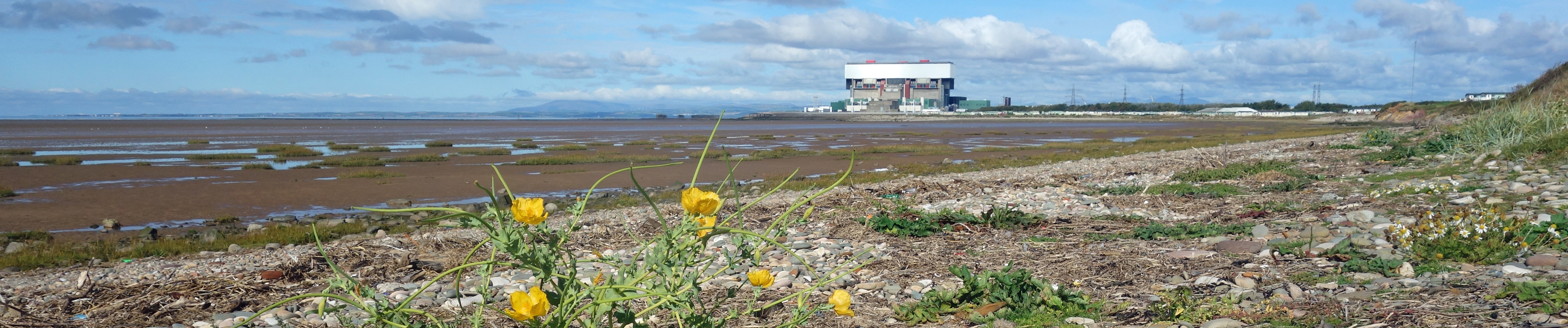
I walked along a coastline that
was pristine, if ordinary, 200 years ago. Today we have thoroughly trashed it.
Right: From Middleton Sands
towards Heysham Power Station (with yellow horned-poppy in the foreground).
September 2015; SD4157; Potts
Corner - N along 'beach' - Red Nab - and back (partly over the mud); 4 miles.
-23. Great Coum and Gragareth
This was the last of a set of
walks to get to the 70 highest tops within the Lune watershed in the 70 days before
my 70th birthday. I've given the heights of the 70 tops, and my progress, in the route descriptions.
June 2015; SD6779; by Lost
John's Cave - NE - Green Hill (628m) - N - Great Coum (687m) - S - Green Hill,
Gragareth (627m) - W - Three Men of Gragareth - SW - by Lost John's Cave;
9 miles: 70 tops in 56 days, mission accomplished with two weeks to spare.
[To Lancashire’s Highest Point, Wherever It Is]
-24. A Circuit of Upper Borrowdale
This is not the Borrowdale near
Derwent Water but the Borrowdale of the Shap Fells.
June 2015; NY5403; south of
High Borrow Bridge - W - The Forest (528m) - NW - White Howe (530m), Long Crag (493m) - N - Lord's
Seat (524m) - SE - Robin Hood (493m), High House Bank (495m) - NE - Hazel Bank - E - road - S - High
Borrow Bridge; 8 miles: 67 tops in 51 days.
[Crookdale and Horseshoes]
 -25. Baugh Fell
Right: The southern Howgills from
the slope up Baugh Fell
June 2015; SD6991; Tom Croft
Hill - NW - Garsdale Foot - N, E - Knoutberry Haw (676m) - Tarn Rigg Hill (678m) - and
back; 8 miles: 61 tops in 45 days.
[Baugh Fell and Alpacas]
-26. The Calf from Sedbergh
The main memory of this walk is of the
very welcome ice-cream provided at Lockbank Farm.
June 2015; SD6592; near Lockbank
Farm - NW - Winder (473m) - N - Arant Haw (605m), Calders (674m) - E - Great
Dummacks (663m) - W - Bram Rigg Top (672m) - N - The Calf (676m) - S - Sedbergh;
9 miles: 59 tops in 43 days.
[On the Hobdale Fence]
-27. A Langdale Loop
This is not the Langdale of the Lake
District but the Langdale of the Howgills.
June 2015; NY6405; Gaisgill - SE - Longdale,
Langdale Knott (477m) - E - West Fell (542m) - S - Hazelgill Knott (578m) - W - Simon's
Seat (587m) - NW - Middleton (496m) - N, NW - Gaisgill; 11 miles: 53 tops in 42 days.
 -28. The North-Eastern Howgills
This walk was enlivened by buzzards. Two
mewed agitatedly above me near Murthwaite, and then repeatedly swooped aggressively
towards me. Obviously, they had young nearby - but where? I decided, bravely, to walk
up the open fell as buzzards do not nest there.
A few hours later the buzzards swooped again as I returned (I had to get back to the car somehow)
but less aggressively. Thanks to the cluster of tops in the Howgills - another ten bagged on this walk - I
was able to get well ahead of schedule.
Right: Cautley Crag and Yarlside from Wandale Hill.
June 2015; SD7197; by Rawthey
Bridge - NE, N - Murthwaite - N - Harter Fell (521m) - W - Adamthwaite Bank (481m),
Grere Fell (544m) - N - Knoutberry (529m) - W - Green Bell (605m) - SW, NW -
Hooksey Top (586m) - S - Randygill Top (620m) - S - Kensgriff (574m) - S -
Yarlside (639m) - E - Wandale Hill (497m) - E, S - Narthwaite - NE - Rawthey Bridge; 11 miles: 48 tops in 40 days.
 -29. Blea Moor and Great Knoutberry Hill
Wold Fell is not a pleasant top to walk upon.
The top itself is hard to determine and it is surrounded by unpleasant, uneven grassed-off limestone clints.
Right: Ingleborough and the Ribblehead Viaduct from Blea Moor.
June 2015; SD7784; Dent Head
Viaduct - NW - Bridge End - S - Dent Head Farm - SW, SE - Blea Moor (535m) - E, NE - Blake
Rake Road - N, SE, N - Wold Fell (558m), Great Knoutberry Hill (672m) - SW - Arten Gill
Viaduct - W, S - Dent Head Viaduct; 10 miles: 38 tops in 37 days.
[What’s Great about Great Knoutberry Hill]
-30. Calf Top
June 2015; SD6582; Blindbeck
Bridge - N - Castle Knott (538m), Calf Top (610m), Barkin Top - SE, S - Blindbeck
Bridge; 6 miles: 35 tops in 36 days.
[To Calf Top Top]
-31. The North-Western Howgills
On this walk I met two runners who
were attempting the Harvey Howgills, that is, they aimed to run up all 40 named Howgill
tops over 400m in one day (that's about 60km and 3,500m of ascent). Why do people set
themselves these ridiculous challenges? Mind you, many of the Howgill tops are conveniently
huddled together - I visited ten of them on this walk, taking me to nearly half-way
through my 70 Lune tops.
May 2015; SD6299; Carlingill
Bridge - SE - Linghaw (490m) - E - Fell Head, Breaks Head (638m) - SE - Bush Howe (623m) - NW,
NE, NW - Over Sale (520m) - N - Docker Knott (530m) - NW - Hand Lake (495m) - SW - Uldale
Head (530m) - N - Rispa Pike 470m) - E - Hare Shaw (472m) - S - Blease Fell (474m) - SE,
SW - Carlingill Bridge; 10 miles: 33 tops in 32 days.
[Damming the Howgills]
-32. Whernside from Kingsdale
May 2015; SD7179; Kingsdale
Head - NE - Whernside (736m) - W - the road - N, W - High Pike (537m) - SW, S by
Back Gill - Kingsdale Head; 7 miles: 23 tops in 28 days.
 -33. White Hill and Great Harlow
This was two short walks
with the car parked at the Cross of Greet on the Slaidburn Road at the middle of a
sort of figure of eight.
Right: The Three Peaks (Whernside,
Ingleborough and Pen-y-ghent) from Great Harlow.
May 2015; SD6860; Cross of
Greet - S - White Hill (544m) - and back - NE - Crowd Stones - SE - Great Harlow (486m) - W - Grey
Crag, Cross of Greet; 6 miles: 21 tops in 25 days.
[Castles and Towers from the Cross of Greet]
-34. An Extended Wasdale Loop
This is not the Wasdale of the Lake
District but the Wasdale of the Shap Fells. At Wasdale Pike a couple of red deer passed
us and then, as we dropped into Wasdale, a herd of perhaps thirty red deer contoured
around the fell opposite.
May 2015; NY5506; P on A6 - W - Whatshaw
Common (484m) - NW - Little Yarlside (516m), Great Yarlside (585m) - W - Harrop
Pike (637m) - back to Great Yarlside - NE - Wasdale Pike (565m) - SE - P on A6; 10 miles: 19 tops in 23 days.
 -35. Swarth Fell and Wild Boar Fell
Right: Wild Boar Fell from Swarth Fell.
May 2015; SD7298; by Foggy
Hill - SE - Uldale House, Holmes Moss - E - Joseph's House, Swarth Fell
Pike (651m) - NW - Swarth Fell (681m) - N, NE - Wild Boar Fell (708m) - SW - Fox
Hole - W, NW - Foggy Hill; 11 miles: 14 tops in 15 days.
[On Wild Boar Fell]
-36. The Whinfell Ridge above Borrowdale
May 2015; NY6001; by
Borrowdale Wood - S - Grayrigg Pike 478m) - W - Grayrigg Forest (494m) - W - Whinfell
Beacon (472m) - N - Castle Fell (482m) - NW - Mabbin Crag (482m) - E by Borrow
Beck - Borrowdale Wood; 9 miles: 11 tops in 13 days.
-37. Aye Gill Pike
Aye Gill Pike is so apart from
other hills that only this one top could be visited on this outing.
May 2015; SD7087; Dent - NE
via Hall Bank permissive path - Aye Gill Pike (556m) - NW, to Dales High Way - S - Barth
Bridge - SE - Dent; 7 miles: 6 tops in 9 days.
[The Dentdale Diamondss]
 -38. Ward's Stone and Wolfhole Crag
A walk to see how the lesser black-backed
gulls that nest here were getting on. In short, 'not very well'. In long, too long for here.
Right: Wolfhole Crag trig point.
May 2015; SD6063; Barkin
Bridge - SE - Alderstone Bank - SW, on track - Brown Syke - E - Wolfhole Crag (527m) - W -
Brown Syke, Grey Crag, Ward's Stone (561m) - NE, N - High Stephen's Head - NW, N -
Mallowdale, Barkin Bridge; 14 miles: 5 tops in 6 days.
[To Ward's Stone: A Classic Walk?]
-39. Ingleborough from near Ribblehead
This was the first walk in
the 70-in-70-by-70 challenge (explained in -23 above). Although it was late April, it was
cold on the snowy top of Ingleborough. Two lady walkers in shorts had red raw legs.
April 2015; SD7578; by Sleights
Pasture - SE - Park Fell (563m) - SW - Simon Fell (650m), Ingleborough (723m) - SW, NW - Tatham
Wife Moss - NE - Meregill Hole, Scar Close, Sleights Pasture; 10 miles: 3 tops in 2 days.
 -40. Winmarleigh Moss
I went to see how the project to
re-wet Winmarleigh Moss, a rare remnant of a lowland raised bog, was progressing. It was
odd to see the wet bog a metre or so higher than the surrounding drained farmland.
Right: Winmarleigh Moss (the
re-wetted part to the right, farmland to the left).
April 2015; SD4551; Cocker
Bridge - SE - Great Crimbles, Hardhead - SE, SW (along Crawley's Dyke) - Poplar
Farm - N - Moss Edge Farm - NE - Great Crimbles - N - Cocker Bridge; 8 miles.
-41. Dowbiggin, at the foot of Baugh Fell
This was a short walk mainly to see the alpacas at Ghyllas.
March 2015; SD6792; Straight
Bridge - E - Fellgate - NE - Nor Gill - SW - Hebblethwaite Hall, Ghyllas, Straight Bridge; 5 miles.
[Baugh Fell and Alpacas]
-42. Ward's Stone
I think that the two lady walkers
met on this walk looking for the ‘luncheon hut’ marked on the map thought that it would
provide a luncheon for them.
March 2015; SD5754; by church
on Long Lane - SE - Top of Emmetts - NE (Wyre Way) - Tarnbrook - N - luncheon hut - NW - Ward's
Stone Breast - NE - Ward's Stone - S - luncheon hut - and back; 8 miles.
[To Ward's Stone: A Classic Walk?]
-43. Beetham
A walk after visiting the garden
centre, seeing kingfisher and nuthatch (at the same time) and hearing woodpecker.
February 2015; SD4979; Garden
Centre - S - Beetham Hall, Hale - E through Marble Quarry - NW - Fairy Steps - N, NE - Garden
Centre; 4 miles.
[An Autumn Stroll through Beetham Woods]
 -44. Barbondale
I went wondering if the wrens that
frolic by Barbon Beck in the summer are still there in the winter. They aren't. I suppose
they hunker down in the woods. I did see dippers though.
Right: Barbon Beck.
January 2015; SD6282; Barbon
village hall - N, E (through wood) - Blindbeck Bridge - N (on west bank) - Short
Gill - S, W (on road) - Barbon; 8 miles.
[Barbondale and the Dent Fault]
-45. Loughrigg Fell
A post-Christmas stroll on Loughrigg
Fell, shortened by a slip and bashed knee.
December 2014; NY3506; White
Moss - S - Loughrigg Terrace, Loughrigg Fell - and back; 2 miles.
[A November Day around Grasmere and Rydal Water]
-46. Blea Moor and Dent Head
I went to see what was happening
with the Mossy Bottom Plantation. Good news: the Sitka was being felled. Bad news: it was
being replaced by young Sitka.
December 2014; SD7679; by
Ribblehead Viaduct - N - Little Dale, over Blea Moor Tunnel, Dent Head Farm - SE, S -
Gearstones - SW - Ribblehead Viaduct; 9 miles.
[Three Viaducts and a Tunnel of the Settle-Carlisle Railway]
 -47. The Lune above Loyn Bridge
I wanted to see where some rare wolf
spiders live (too rare for me to expect to see the wolf spiders themselves).
They apparently live among the pebbles at the river-side, somehow surviving floods.
Right: Loyn Bridge at Hornby.
September 2014; SD5869; Loyn
Bridge - N by Lune - Arkholme - and back; 4 miles.
 -48. Moughton and Crummackdale
I had heard that the juniper (now
rare in the Dales) on Moughton had become diseased. We found juniper dying of old age
but couldn't really see signs of a recent disease. We didn't search long, preferring
instead to wander over Moughton Scars.
Right: Pen-y-ghent from Moughton.
September 2014; SD7668; by
Austwick Bridge - NE - Wharfe - NW, N, NE - Whetstone Hole - S - Moughton trig point - N,
NW along Moughton Scars - Beggar's Stile - S - Crummack, Austwick Bridge; 9 miles.
[Crummackdale: These Are a Few of My Favourite 'Superficial Things']
-49. Pike of Blisco from Wrynose
A short walk but with a heavy backpack (a grandchild).
August 2014; NY2702; Three Shire
Stone, Wrynose - NW, NE - Pike of Blisco - SE - Wrynose Bridge - SW - Three Shire Stone; 3 miles.
-50. Lawkland Moss
This was actually two short walks, a week
apart, in search of the small pearl-bordered fritillary (first walk, no; second walk, yes).
June 2014; SD7665; Eldroth - N -
Middlesber - E - Lawkland - SW - Eldroth; SD7668; by Austwick Bridge - S - Owlet Hall,
Middlesber - E - Lawkland - N - Austwick Bridge; 6 miles.
-51. Lowgill in Tatham
A figure of eight walk, using three
bridges, around the village of Lowgill.
June 2014; SD6367; by
Ridges - S - Furnessford Bridge, Lower Houses - SE - Lowgill - S, SW - Stairend
Bridge - N - Over Houses Great Wood - E - Mill Bridge - N - Spen Row - NW - Ridges; 9 miles.
[Westward Home! (from Lowgill with Thoreau)]
-52. From the Crook o'Lune to Halton Bridge
One of many short walks from
the Crook o'Lune (the only one I'll add here).
June 2014; SD5264; Crook o'Lune - W -
Halton Bridge - E - Halton Mills, Crook o'Lune; 3 miles.
[The Lune Millennium Park Artworks]
 -53. Roundthwaite and lower Borrowdale
Fell ponies and skylarks.
Right: Lower Borrowdale from Belt Howe.
April 2014; NY6003; Roundthwaite -
SW, W - Belt Howe - NW - Roundthwaite Common, Whinash, Breasthigh Road - SW -
Borrow Beck - SE - Low Borrowdale - E - Belt Howe - NE - Roundthwaite; 9 miles.
[Reflections from Jeffrey's Mount]
-54. Clougha from The Cragg
April 2014; SD5461; Little
Cragg - W - Bark Barn - S, SE along track, N - Sweet Beck, Little Cragg; 5 miles.
[Cloughs and Grit: Clougha Pike and Grit Fell]
 -55. Ingleborough from near White Scar Caves
On a walk to see the purple
saxifrage I came across a cagoule with car-keys, probably forgotten by someone who had
taken it off for a pause and snack. I
left it there and noticed it was still there on my return some hours later.
What to do? I couldn't think what else to do but leave it there
but driving home through Ingleton I noticed a police station so I told
them. They more or less told me to go back for it and bring it to them, which I did.
I also tried the keys in the few vehicles parked in the lay-by and left a note on the windscreen of
the camper van that they fitted. Whether the driver was happy about that, I don't know.
Right: Ingleborough from Raven Scar, with old landslip prominent.
March 2014; SD7175; layby by disused
quarry - E over Tatham Wife Moss - Black Shiver (where I potted about amongst the purple
saxifrage) - E - Ingleborough - SW, S - layby; 5 miles.
[Is the Purple Saxifrage on Ingleborough in Flower Yet?]
-56. Barbondale and Kirkby Lonsdale
Two short walks, before and after a Barbon Boxing Day lunch.
December 2013; SD6282;
Barbon - N, E - Blindbeck Bridge - W - Barbon; SD6178; Devil's Bridge - N, NW -
Ruskin's View - S, SE - Devil's Bridge; 6 miles.
[Low in Low Barbondale]
-57. Roeburndale, below Whit Moor
Many starlings and a bird of prey.
November 2013; SD5863; by
cattle grid - SE - Haylot Farm - N - Thornbush - SW - cattle grid; 5 miles.
 -58. Murthwaite and The Clouds
Right: Fell End Clouds, with
its lone sycamore (Wild Boar Fell in the cloud).
September 2013; SD7197; Rawthey
Bridge - NE, W, NW - Murthwaite - E - Streetside - N - Cold Keld - E - Fell End
Clouds - SW - Wraygreen, Rawthey Bridge; 6 miles.
[Fencing The Clouds]
-59. Reston Scar, Staveley
August 2013; SD4698;
Staveley - NW - Reston Scar - N - Black Crag - SE - Staveley; 3 miles.
-60. Heysham Moss
I went to see how Heysham Moss had
been affected by the disastrous fire reported in the paper - I could see no sign of it. It must
have recovered quickly! Or the paper exaggerated.
July 2013; SD4462; (linear) VW
garage - SW - North Farm, Heysham Moss - W, NW - Lower Heysham - NE - The Platform; 7 miles.
[Passing the Time at Heysham]
 -61. Great Asby Scar and Sunbiggin Tarn
I searched for flowers on the
limestone scars and around the tarn. Plenty of orchids. I was puzzled by a bogbean
with the wrong number of petals. I see now that I photographed a bird's eye primrose without knowing it.
Right: Below Great Asby Scar (guess which field doesn't have sheep in it).
June 2013; NY6208; Orton - E - stone
circle - N, NW - Little Kinmond - S - Sunbiggin Tarn - W - Raisbeck, Orton; 10 miles.
[Orchids and Bogbeans at Sunbiggin]
-62. Robert Hall Moor, near Bentham
Robert Hall Moor is a SSSI as a rare
example of unimproved grassland in Lancashire, but it didn't look anything special to me.
June 2013; SD6569; Low
Bentham - SW - Hunter's Barn - W, S, W - Perry Moor - N, E - Hunter's Barn - NE - Low Bentham; 4 miles.
 -63. Green Bell and Randygill Top
This was the first of a series of walks
investigating the local wildlife, for the document that became
The Wildlife of the Lune Region. I began at the
source of the Lune, Green Bell, intending to work my way down the river but I soon realised that
I needed to be at the right place at the right time for wildlife.
Right: The northern Howgills from Green Bell trig point.
April 2013; NY7103; Greenside,
Ravenstonedale - SW - Green Bell, Randygill Top - and back; 8 miles.
-64. From Hornby by the Lune
We took the bus to Hornby and walked
back alongside the Lune (using a permissive path to Claughton Beck that is no longer available:
the bridge has been washed away).
March 2013; SD5868; (linear)
Hornby - SE on south bank of Wenning and Lune - Bull Beck - S - Brookhouse; 5 miles.
 -65. Pike of Blisco from Blea Tarn
An Easter walk in the snow.
Right: Crinkle Crags and Bowfell from Pike of Blisco.
March 2013; NY2904; Blea Tarn - N,
W, SW - Pike of Blisco - SE - Wrynose Bridge - E, N - Blea Tarn; 5 miles.
-66. Raise ski-lift
I walked up with skis (for Ruth), then walked on.
February 2013; NY3617; Glenridding
youth hostel - NW, W along The Chimney - ski-lift - and about, and back; 5 miles.
-67. Malham Cove
A post-Christmas, post-lunch
stroll over Malham Cove, including a foot stuck in a grike.
December 2012; SD9062; Malham - N - Malham
Cove - SE - Malham; 4 miles.
 -68. Millom Park
Right: Lake District hills (Coniston
hills central) from Millom Park.
October 2012; SD1782; layby east
of Park Plantation - clockwise around Millom Park - layby; 3 miles.
-69. Black Combe
After a ride (not me, Ruth) on Silecroft beach.
The Isle of Man seemed very close.
October 2012; SD1382; Murthwaite Green
Farm - N - Black Combe - and back; 6 miles.
[Along the Sands from Millom to Silecroft]
-70. Highfields from Crook o'Lune
We gathered from a farmer that he
wasn't overly fond of foxes and badgers.
October 2012; SD6264; Crook
o'Lune - NE - Hawkshead, beyond Middle Highfield - and back; 5 miles.
[Wayfinding and the Highfields]
-71. Dunsop Bridge and Middle Knoll
There were swallows still nesting, late September.
September 2012; SD6550; Dunsop
Bridge - N - Foot Holme - anticlockwise around Middle Knoll - and back; 8 miles.
 -72. Whernside from Chapel-le-Dale
Right: Ingleborough and hang-glider from Whernside.
September 2012; SD7477; Old
Hill Inn - SW, N - Bruntscar, Whernside - and back; 7 miles.
-73. Norber
One of a few short walks on a
drive around Ribblehead Viaduct, Horton and Norber.
July 2012; SD7668; Austwick -
N - Norber - and back; 3 miles.
[An Erratic Saunter from Austwick]
-74. The Belhill loop
At the end of 2010 I decided to write something each
week in 2011 about running, which became
Fifty Weeks Running. In parallel, I tried to run more than
I had managed in recent years. I did and by the end of the year I was running further each week (although
slower, of course) than I had for twenty years or more. A standard run from home was what I called the Belhill loop.
December 2011 ; SD5464; Brookhouse -
SE - Udale Bridge, Bellhill Farm - E - Field Head - NE - Littledale Hall - W, NE, W - Brookhouse; 8 miles.
[A Walk in Littledale in 1847]
-75. From Sellet Hall
A short walk while some horse event was happening at Sellet Hall.
November 2011; SD5185; Sellet
Hall - E, N - Crosscrake - NE - Mill Bridge - S, SW - Stainton, Sellet Hall; 3 miles.
 -76. Blind Tarn from Torver
Right: Dow Crag and The Old Man of Coniston.
October 2011; SD2894; Torver - N, NW - Torver
Bridge - E - Blind Tarn - and back; 6 miles.
-77. Torver from Park Coppice
This walk from the Park Coppice camp-site
included a meal in Torver followed by a walk back in the dark (by mobile phone light).
October 2011; SD2995; Park
Coppice - NE, S on Cumbria Way - SW - Reservoir - N - Torver - NE - Park Coppice; 6 miles.
-78. Around Thurnham Moss
October 2011; SD4556; Conder
Green - W - Brows Bridge - S, W - Bank End - W, N - Cockersand Abbey - NE - Glasson, Conder Green; 8 miles.
[Whoopers on Thurnham Moss]
-79. From Slaidburn along the Old Salt Road
With my recently regained running fitness,
I planned to run for 60 minutes from Slaidburn up the Old Salt Road and then run back - but
I had to settle for 55 minutes because a small herd of Belted Galloways became excited by
my running and ran ahead of me to demolish a fence (sorry about that: I assumed that they
would stop at the fence, not run right through it). I thought I’d better not excite them further.
October 2011; SD7152; Slaidburn -
NW, N - Higher Wood House - NW - the fence before Hard Hill Top - and back; 11 miles.
[A Grand Bowland Circuit, plus Easington Fell]
-80. Melling Wood and Mallowdale
September 2011; SD5863; by cattle
grid - E, SE - Mallowdale - E, N - Middle Salter - S - Haylot Farm - NW, W - cattle grid; 4 miles.
-81. Around Semer Water
It was twenty years or so since I had
gone out for a run like this. I particularly enjoyed the long run along the
Roman road into Bainbridge.
September 2011; SD9390; Bainbridge -
S on Blean Lane - Stalling Busk - W - Marsett - NE - Countersett - E, N, E - Cam High Road - NE -
Bainbridge; 11 miles.
[The 'Hillfort' of Addlebrough]
-82. Farleton Knott
A short walk on the way to collect music.
Saw a fox scampering over the crags.
September 2011; SD5279; Holme -
W - Holmepark Fell - N - Farleton Knott - S on grassy strip - Holme Park Farm; 4 miles.
[Trail-Blazing on Farleton Knott]
-83. Home from Bolton-le-Sands
A number of my runs (and more recently
walks) have been ‘tip-outs’, that is, when Ruth is driving somewhere and I hop in to be
tipped out along the way and left to get back home on foot. I’ll mention a few tip-out
runs of this year (2011) to represent them.
September 2011; SD4867; (linear)
Bolton-le-Sands - S by canal - Lune Aqueduct - E on old railway line, S - Brookhouse; 9 miles.
[Turner and the Lune Aqueduct]
-84. Home from Warton
September 2011; SD5172; (linear)
layby on A6 - N, E on Borwick Lane, S on Kellet Lane - Over Kellet - SW - Newlands Farm - S -
Halton Green - SE, E, S - Brookhouse; 9 miles.
[From Millstone Grit to Limestone]
-85. Home from Netherby, Gressingham
From where Ruth used to ride.
August 2011; SD5569; (linear)
Netherby - S - Aughton, Aughton Barns - SW - Waterworks Bridge - S - Brookhouse; 5 miles.
[The Small-Leaved Limes of Aughton Woods]
-86. Home from Arkholme
In a variant of a tip-out, I drove
to Arkholme, ran home, and, later, took a bus back to get the car. The route was
difficult in places because it was submerged under Himalayan balsam.
August 2011; SD5872; (linear)
Arkholme - S on Lune Valley Ramble - Loyn Bridge - SW - Waterworks Bridge - S - Brookhouse; 8 miles.
[With the Lune from Kirkby Lonsdale]
 -87. Smardale and Scotch Argus
We went looking for Scotch Argus
butterflies (which are found in only a few places in England). We picnicked among hundreds of them.
Right: Smardalegill Viaduct.
August 2011; NY7308; Smardale
Hall - SW on old railway line - old quarries - NE - Smardale Fell - N - Smardale Hall; 5 miles.
[The Scotch Argus of Smardale]
-88. Abbeystead
It was too hot. Everything (including me)
drooped in the heat.
August 2011; SD5457; Jubilee
Tower - SE, S - Meeting House Farm, Cross Hill - E - Stoops Bridge - S - Hawthornthwaite,
Cam Brow - E - Well Brook - NW, SW on Long Lane, NW on Abbeystead Lane - Jubilee Tower; 10 miles.
[Why? On the Wyre Way]
-89. Conder Head
July 2011; SD5461; Little
Cragg - SE, SW - below source of River Conder - W - Birkbank - NE - Bark Barn - E - Little Cragg; 4 miles.
[Up the Conder]
-90. Trough of Bowland
I intended to run up to Wolfhole Crag but
the moor was closed because of fire risk, so I settled for a run along the road through the
Trough of Bowland to Dunsop Bridge and back.
May 2011; SD6053; Tower Lodge - SE
through Trough of Bowland - Dunsop Bridge - and back; 10 miles.
[Dunsop Bridge, Whitewell and Duchy-land]
-91. Roeburndale and the Old Salt Road
For the first time for many years I felt
fit enough to justify taking the car for a run on the hills, but I kept it simple: I ran
along the Old Salt Road into Roeburndale for 45 minutes and then turned and ran back.
April 2011; SD5965; by cattle
grid - S - Lower Salter - SE - Alderstone Bank - and back; 10 miles.
[The Long and Winding Hornby Road]
-92. To The Cragg
As I became fit in 2011 I re-discovered
many local runs that I had not tackled for years. I’ll just mention three of them.
March 2011; SD5464; Brookhouse - SE -
Udale Bridge - SW - The Cragg - SE, E, N - Belhill Farm, Udale Bridge - NW - Brookhouse; 6 miles.
[The Littledale Cuckoos are Back!]
-93. Around the Caton Windmills
March 2011; SD5464; Brookhouse -
SE, E - Roeburn Glade, second cattle - N, NW - old quarries - W - Brookhouse; 8 miles.
[Around the Windmills of My Mind, Metaphorically Writing]
-94. To the Caton Moor Trig Point
It always used to be a simple test
of my fitness if (and how fast) I could run, uphill all the way, to the local hill’s trig point.
February 2011; SD5464;
Brookhouse - E - Caton Moor trig point - and back; 7 miles.
[The Taming of Caton Moor]
-95. Longridge Fell
January 2011; SD6340; Cardwell
House car park - NE - Spire Hill - and back; 4 miles.
 -96. Gatescarth Pass, Longsleddale
A Boxing Day outing. Some of us
preferred to return over Kentmere Pike and Shipman Knotts in the snow; others (including me)
opted to go back down the pass.
Right: Gatescarth Pass.
December 2010; NY4805; Sadgill - N -
top of Gatescarth Pass - and back; 6 miles.
[The Longsleddale Green Lane]
-97. Raise
A reconnaissance mission, to
locate The Chimney (after the problems mentioned in walk -103 and in preparation for,
for example, walk -66). The Chimney was a sort of on-the-ground chimney that took
smoke from the quarry away uphill. We continued to Raise and became a little disoriented in the cloud.
October 2010; NY3617; Glenridding
youth hostel - NW, W along The Chimney - ski-lift, Raise, along ridge - and back; 6 miles.
-98. Across the Howgills, from Sedbergh to Ravenstonedale
I don’t normally meet people on
the Howgills but this time I had two odd encounters. First, on Calders a couple refused to
believe that they were not at The Calf even though I pointed out The Calf trig point ahead.
Then, at The Calf, a group seemed to find my arrival amusing. Maybe I looked too old (65 at that time)
to be running about on the Howgills. It took me 2 hours 20 minutes
for the south-north crossing.
July 2010; SD6592; (linear) Lockbank
Farm - NW, N - past Winder, past Arant Haw, Calders, The Calf - NE - Yarlside - N -
Kensgriff, Randygill Top - NE - Green Bell , Knoutberry, Town Head, Ravenstonedale; 10 miles.
-99. Hayshaw Fell, Bowland
June 2010; SD5349; Grizedale
Bridge - NE - Grizedale Fell - N - Stones (with inscriptions), as it says on OS map - W -
Foxhouses Brook - S - Grizedale Bridge; 4 miles.
[Heather on Hawthornthwaite Fell]
-100. Roeburndale and Mallowdale
June 2010; SD6065; above
Backsbottom Farm - E, across Roeburn - road - S - Stauvin, Harterbeck - SW - High
Salter, Mallowdale - NW - Haylot Farm - N - above Backsbottom Farm; 9 miles.
[Return to Roeburndale]
-101. From Horton-in-Ribblesdale to Birkwith Moor
April 2010; SD8072; Horton - N,
along Pennine Way - Birkwith Moor - W - Old Ing - N - Ling Gill Bridge - W, SW - Nether
Lodge - SE - High Birkwith - S - Scale Pasture - E - High Pasture - S - Sell Gill Holes, Horton; 11 miles.
[Upper Ribblesdale: Drumlins, Three Peaks and a Cave]
-102. From Keswick around Glenderaterra Beck
April 2010; NY2822; Castlerigg
Farm - E, N - stone circle - NE (under A66) - Wescoe - NW, N - ford across Glenderaterra
Beck - S, SW - Latrigg, Keswick - SE - Castlerigg Farm; 10 miles.
 -103. Bleaberry Fell
Two of us (including me) opted to walk
on Bleaberry Fell; and two of us opted to ski (in April!) at Raise (the latter two
missed The Chimney and floundered somewhat in snow drifts before reaching the ski-lift).
Right: Skiddaw from Bleaberry Fell.
April 2010; NY2822; Castlerigg
Farm - S, SE - Castlerigg Fell - S - Bleaberry Fell - W - Brown Knotts - N - Castlerigg Farm; 5 miles.
[Viewpoints around Keswick (part 1)]
-104. Grit Fell from Jubilee Tower
March 2010; SD5457; Jubilee
Tower - SE - Lower Lee - NW - Tarnbrook - N - luncheon hut - NW, W across
Dunkenshaw Fell - luncheon hut - N - watershed - W - Grit Fell - SW - Jubilee Tower; 9 miles.
 -105. Around Pilling
This was the last of many
walks 'researching' for the (second edition of)
The Land of the Lune book.
Right: Towards Pilling from Lane Ends.
March 2010; SD4149; Lane Ends - SE -
Moss House - SW - Bond's Farm - SE - Bone Hill Bridge - W - Bradshaw Lane - N - Broadfleet
Bridge - NE - Land Ends; 6 miles.
[Walking around Pilling with Pink Feet]
-106. Clapdale
February 2010; SD7469;
Clapham - E, N along Long Lane - Grange Rigg - W, SE - Trow Gill - S - Clapham; 7 miles.
[Up Ingleborough with the Holiday Crowds]
 -107. Up Blackberry Lane
Our most common short walk is
up what we call Blackberry Lane. After a mile or so, from the gate, we can see the
Lake District tops, and a little further we see Ward's Stone, the highest point of
Bowland, and from the top we see the Dales' Three Peaks. I just include this entry
to represent many such walks.
Right: The Lune valley and,
beyond the ridge, some of the Lake District tops.
February 2010; SD5464;
Brookhouse - SE - bridge over Traitor's Gill - and back; 4 miles (beyond the
gate is now private).
-108. Easedale Tarn
A post-Christmas walk in snow.
December 2009; NY3307;
Grasmere - NW - Easedale, Easedale Tarn - and back; 7 miles.
["The Prettiest Mere of All" Lakeland]
 -109. Ribblehead Viaduct
Right: The Ribblehead Viaduct and Pen-y-ghent.
November 2009; SD7679; Blea
Moor Road - NW, N - aqueduct - SW - Winterscales - S -
Gunnerfleet Farm - E - Blea Moor Road; 5 miles.
[Three Viaducts and a Tunnel of the Settle-Carlisle Railway]
-110. Middleton Fell
October 2009; SD6289; layby
on A683 - E - Fellside - E, SE - Barkin Top - SW -
Calf Top - NW - Cartsaddle Hill - NE, N, W - Fellside, layby; 9 miles.
-111. Great Shunner Fell from Hardraw
October 2009; SD8691; Hardraw -
NW - Cotterdale - N, NE - Great Shunner Fell - S, SE along Pennine Way - Hardraw; 12 miles.
 -112. Around Dockray and Aira Force
This was a walk between two
concerts of the Lake District Music Festival, at Penrith and Ambleside.
Right: The head of Ullswater.
August 2009; NY3921; P near
Parkgate Farm - E, N, W - Dockray - SW - below Swineside Knott - NE - Aira Force - N, W - P; 5 miles.
[From Glenridding to Pooley Bridge on the Ullswater Way (Western Half)]
-113. Green Bell
A walk up Green Bell while others
were rehearsing for the Ravenstonedale Prom.
July 2009; NY7204;
Ravenstonedale - W, SW - High Cocklake, Green Bell - E, NE - Town Head, Ravenstonedale; 7 miles.
-114. Goodber Common
It was very quiet and isolated on Goodber
Common, apart from the curlews and lapwings angry at their nesting being disturbed.
June 2009; SD6563; Stairend
Bridge - W, SW, permissive path - Summersgill Fell - N - Grey Stone, Jack's Nook - W -
White Moss, Stairend Bridge; 5 miles.
 -115. Scafell Pike from Wasdale
With friends (not serious walkers) who
wanted to conquer England's highest peak.
Right: Lingmell and Great Gable from Scafell Pike.
May 2009; NY1807; P at
Brackenclose - E - Mickledore - NE - Scafell Pike - NW - Lingmell - W, SW - P; 6 miles.
-116. Leck Valley
May 2009; SD6376;
Cowan Bridge - NE - Ease Gill Kirk - and back; 8 miles.
[In the Lancashire Yorkshire Dales]
-117. The Upper Lune
May 2009; SD6805; Wath -
W - Potlands, Kelleth - S - Cotegill - E - Bowderdale - SE - Weasdale - N - Gars, Wath; 7 miles.
-118. Around Winmarleigh
Pilling Moss is very flat - the farms
are on tiny hillocks, two of which were called Island Farm.
April 2009; SD4847; A6
layby - W - Davis Bridge, Winmarleigh Hall, Gift Hall - SW - Island Farm - S -
(another) Island Farm - SE, N - Nateby Hall - NE, along canal - Davis Bridge - E - layby; 7 miles.
[Bogged Down around Rawcliffe Moss]
 -119. Crag Hill
Right: The Howgills from Richard Man.
February 2009; SD6681;
Bullpot - NE - Richard Man, Crag Hill - NE - Short Gill Bridge - SW - Blindbeck
Bridge - SE, S - Bullpot; 8 miles.
[Barbondale and the Dent Fault]
-120. Dow Crag and The Old Man of Coniston
A Boxing Day walk in heavy frost.
December 2008; SD2894;
Torver - NW - Walna Scar - N - Brown Pike, Dow Crag - NE, SE - The Old Man of Coniston -
S, over Little Arrow Moor - SE - Torver; 8 miles.
[Up and Up to Dow Crag]
-121. Black Force
November 2008; SD6299;
Carlingill Bridge - E - Black Force - S, on east ridge - footpath - SW -
Linghaw - NW - Carlingill Bridge; 5 miles.
-122. To Aughton from Home
November 2008; SD5464; Brookhouse -
N - Waterworks Bridge - NE (higher path in Lawson's Wood) - Aughton Barns - N - Aughton -
around triangle - and back (on lower path), Brookhouse; 7 miles.
[Walking Uphill and Walking Up a Hill]
 -123. A Circuit of Bowderdale
Right: Langdale from West Fell.
September 2008; NY6805;
Wath - SW - Bowderdale, West Fell - S, SW - The Calf - NE - Bowderdale Beck,
Yarlside - N - Randygill Top - NE - Green Bell - S - Weasdale - NW - Gars, Wath; 14 miles.
-124. Fell End Clouds and Uldale Gill
We had our lunch break overlooking
three streams gushing from the bank of Uldale Gill, indicating that we were on the
line of the Dent Fault, with a transition from limestone to millstone grit.
September 2008; NY7300;
old quarry - SE - above Fell End Clouds - S - Uldale Gill - S - Whin Stone Gill
Bridge - NW - Streetside - NE - quarry; 9 miles.
[Fencing The Clouds]
-125. Ease Gill
There were tadpoles at Ease
Gill Kirk. It must have its own micro-climate.
September 2008; SD6681;
Bullpot - E, SE - Ease Gill - W - Ease Gill Kirk - N - Bullpot; 4 miles.
 -126. Hawthornthwaite Fell Top
The most memorable thing about
this walk was the trig point at the top! It was perched on its concrete base about
five feet above ground level, that amount of peat having been eroded away.
Right: Black Clough, on the way up Hawthornthwaite Fell.
August 2008; SD5953; by
Marshaw Wyre - SE, S - Black Clough - SW, W - Hawthornthwaite Fell Top - and back; 6 miles.
[Heather on Hawthornthwaite Fell]
 -127. Ingleborough and Simon Fell
Right: Whernside and Chapel-le-Dale.
July 2008; SD7175; layby by
old quarry - SE, NW, across Tatham Wife Moss - SE, SW - Ingleborough - NE - Simon Fell -
NW, across Souther Scales Fell - W, across Harry Hallam's Moss, along Raven Scar, layby; 8 miles.
[Early Spring in Chapel-le-Dale]
 -128. Blencathra
This was the second of two walks
from Askew Rigg Farm, marking our anniversary. We did not set out intending to walk up
Blencathra (with snow on top) but we did, as is the way.
Right: Sunset over Blencathra from Askew Rigg Farm.
April 2008; NY3727; Askew
Rigg Farm - W - Southerfell - SW - Mousthwaite Comb - NW - Blencathra - and back; 8 miles.
[Back in the Saddle of Blencathra]
-129. Bannerdale Crags
April 2008; NY3727; Askew Rigg
Farm - N - Mungrisdale - W, around Bannerdale Crags - SE - White Horse Bent - NE, by
River Glenderamackin - Mungrisdale (meal) - S - Askew Rigg Farm; 10 miles.
-130. Masongill and Ireby
February 2008; SD6571;
Burton-in-Lonsdale, by river - N, NW - Masongill Lowfields - N - Masongill - W -
Ireby - S - Burton-in-Lonsdale; 6 miles.
 -131. Crummackdale and Studrigg Scar
This walk was mainly to photograph
the unconformity on Studrigg Scar. Two merlins were squabbling noisily on the cliffs.
Right: Studrigg Scar.
September 2007; SD7668; Austwick
Bridge - NE - Wharfe - N - Studrigg - S - Austwick; 5 miles.
[Crummackdale: These Are a Few of My Favourite 'Superficial Things']
-132. Wansfell
August 2007; NY3704;
Ambleside - E - Wansfell Pike - E, S, Hundreds Road - NW - Ambleside; 5 miles.
[The Red Screes - Wansfell Question]
-133. By Duddon Sands
A short walk before a concert
in Ulverston and a stay at a campsite. In the morning our van needed to be towed out of the mud.
(It was the site owner's fault - they had overbooked and had to place us on a grassy and,
as it became, muddy area.)
August 2007; SD2381; Low Hall
campsite - SW - Soutergate Crossing, Dunnerholme - E - Marsh Grange - N - Soutergate - NE - Low Hall; 5 miles.
 -134. Totridge from Hareden
Right: North-east from Totridge (Ingleborough
just visible in the middle).
August 2007; SD6450; By Hareden
Bridge - S, across Riggs Plantation - SW - Totridge - SW - near David's Tomb - N - Hareden
Fell shooting lodge - N, W, along track - Hareden Farm; 7 miles.
-135. Loughrigg and Elterwater
We walked our Australian friends
over to Elterwater for a good lunch at the pub but then, unbeknownst to us, they ordered a full
cream tea too. It was a bloated walk back.
August 2007; NY3506; White
Moss car park - S - Loughrigg - SE - Elterwater - NE - High Close, White Moss car park; 5 miles.
[A November Day around Grasmere and Rydal Water]
 -136. Striding Edge, Helvellyn and Swirral Edge
The classic Striding Edge loop!
Right: Striding Edge.
April 2007; NY3816; Glenridding -
SW - Striding Edge, Helvellyn - NE - Swirral Edge, Catstye Cam, Youth Hostel - E - Glenridding; 9 miles.
 -137. Roeburndale and Wolfhole Crag
Right: The head of Roeburndale, with the Hornby Road track.
April 2007; SD6063; Barkin
Bridge - SE - High Salter, Alderstone Bank - S, on track - Brown Syke - E - Wolfhole Crag - and back; 14 miles.
[The Long and Winding Hornby Road]
-138. Calf Top and Great Coum
This walk was part of an
orchestra's 'away weekend'. The walk organisers had not allowed for the varying walking
fitness of the walkers. The walk proved far too long, with some being left behind to
straggle back late. There was a barn dance in the evening! (Not for me.)
April 2007; SD6282; Barbon -
N, E, NE - Castle Knott, Calf Top, Barkin Top - SE, track on South Lord's Land - S,
SE, S - Great Coum - SW - Crag Hill, track near Bullpot - NW, W - Barbon; 14 miles.
[To Calf Top Top]
-139. Bowber Head, Bents, Clouds and the Rawthey
We had a number of short walks
to/from/during a stay at Bowber Head campsite, none warranting a full entry, so just
brief details: around Bowber Head to the Fat Lamb (and back in the dark); around Brownber
and Bents Farm, north of Newbiggin-on-Lune; on Fell End Clouds; by the Rawthey from
Middleton Bridge, where we came across strange holes in the bank (for worms, by mink?).
 -140. Murthwaite Park and Wandale Hill
I had promised Ruth that we'd see red squirrels
(as I had seen them here recently (well, one, anyway)),
and we did (well, one, anyway).
Right: Swarth Fell and Baugh Fell from Wandale Hill.
February 2007; SD7197; by
Rawthey Bridge - E, W - Murthwaite Park - N - Adamthwaite - W, S - Wandale Hill,
Narthwaite - E - Rawthey Bridge; 5 miles.
-141. Levens Water and Boulder Valley
A Boxing Day walk in the cloud (with one
of the party non-plussed that this should be considered a fun activity for Boxing Day).
December 2006; SD63097; Coniston -
NW - Levens Water - S, in Boulder Valley - SE - Coniston; 5 miles.
-142. Thornton Force and Kingsdale
December 2006; SD6975; by Ravenray
quarry - N, E, S - Thornton Force - NW - Tow Scar, Turbary Road - NE - Rowten Pot, Jingling
Pot, Yordas Cave - S - Ravenray quarry; 7 miles.
[Caves, a Waterfall, Windmills and a Crocodile]
-143. Birkbeck Fells
November 2006; NY5506; P on A6 -
N, NW - Wasdale Old Bridge, Shap Wells Hotel, Galloway Stone - S - Salterwath,
Scout Green - W - Rampshowe - N - Castlehow - SW - P on A6; 9 miles.
-144. Green Bell and Bowderdale
A walk to the source of the River Lune.
November 2006; NY6805; Wath -
S - Weasdale - SE, S - source of Lune - SW - Green Bell, Randygill Top - W - Bowderdale
Beck - N, NE - Wath; 9 miles.
-145. Grayrigg Pike
September 2006; NY6000; P by
Hause Bridge - SW, S - Grayrigg Pike - NW - Repeater Station - NE, E, S - P by Hause Bridge; 5 miles.
 -146. Brownthwaite Pike
A walk passing the Goldsworthy sheepfolds along Fellfoot Lane.
Right: From Brownthwaite Pike towards Kirkby Lonsdale.
September 2006; SD6282; Barbon - S -
Fell Garth - SE - Fellfoot Lane - N, E, by Drygill Wood - SE - Brownthwaite Pike - NW, S, N - Barbon; 6 miles.
[Ruskin’s View and a View of Ruskin’s View]
-147. Orton Fells
The walk across the limestone pavement
to Little Kinmond is not to be recommended - care is needed over the loose stones and grikes.
September 2006; NY6208; Orton -
N - Broadfell, quarry - E - Beacon Hill - SE - Castle Folds, Little Kinmond - SW -
Acres - W - Scarside, Orton; 7 miles.
[Pink Stones on the Orton Fells]
-148. Lawkland
August 2006; SD7565; School
Bridge - S, SE - Howith - N, E, NE - by Lawkland Hall - W, Lawkland Moss, Austwick Moss -
S - School Bridge; 6 miles.
 -149. Cockersand Abbey
After this photo appeared in
The Land of the Lune I received a nice letter from the
man sailing this boat, telling me the history of this distinctive craft, among other things.
Right: Plover Scar lighthouse.
August 2006; SD4552; Pattys Farm -
NW, W - Bank End - W, NW, N - Cockersand Abbey, Plover Hill, Crook Cottage - E -
Kendal Hill - S, E, S - Pattys Farm; 6 miles.
[Whoopers on Thurnham Moss, plus Cockersand Abbey]
 -150. Roeburndale, along Hornby Road to Alderstone Bank
Right: Gragareth, Whernside,
Ingleborough and Pen-y-ghent from Roeburndale
August 2006; SD6065; above
Backsbottom Farm - S - Lower Salter - SE - Alderstone Bank - SW - shooting cabin - and back; 12 miles.
-151. Swarth Fell from Rawthey Bridge
August 2006; SD7197; Rawthey
Bridge - SE, by waterfalls - Rawthey Gill Foot - NE - Joseph's House, Swarth Fell - NW,
W by Uldale Gill - Needle House - NW - Rawthey Bridge; 10 miles.
-152. Old Town, Rigmaden and Mansergh
August 2006; SD5982; by
Terrybank Tarn - N - Beck Head - NE, E, NE - Rigmaden Park - S - Mansergh Hall - N, W -
Old Town - S - by Terrybank Tarn; 7 miles.
-153. Along the Rawthey at Sedbergh
July 2006; SD6691; by bridge
at Millthrop - around Millthrop - NE, by Rawthey - Buckbank - SW - Sedbergh, Millthrop; 4 miles.
-154. Killington and Park Hill
July 2006; SD5988; Hills
Quarry - NE - Killington, Stangerthwaite - SW, S - Beckside - SW - Harprigg - NW, across
Park Hill - Hills Quarry; 7 miles.
 -155. Whernside and Deepdale
A way up Whernside that is rather
less busy than the Three Peaks route,
Right: Dentdale and Deepdale, with
the Howgills in the distance.
July 2006; SD7179; Kingsdale
Head - NE - Whernside - N - Whernside Tarns - W - Deepdale Head - S - Kingsdale Head; 9 miles.
-156. Keasdendale
Keasdendale doesn't really exist. It's
just the name I've used for the valley within which Keasden Beck flows and which was all
out of bounds before the CROW Act of 2000.
June 2006; SD7260; Bowland Knotts -
W - Ravens Castle - NW - Crowd Stones - N - Thistle Hill - E - Gregson's Hill - SE -
Bowland Knotts; 6 miles.
[Castles and Towers from the Cross of Greet]
 -157. On the Western Slopes of Ingleborough
Right: Whernside from White Scars.
June 2006; SD6975; quarry at Raven
Ray - N, SE - Beezleys, White Scars - NE - Souther Scales - W - Chapel-le-Dale - SW -
Beezleys - NW - quarry at Raven Ray; 11 miles.
-158. Fox's Pulpit and Brigflatts
A walk incorporating the two most
important Quaker sites in the Lune valley.
June 2006; SD6290; Killington New
Bridge - S, E - Greenholme - NW - Lily Mere - NE - Ghyll Farm, New House - N - Fox's
Pulpit - E, N - Goodies - E - Hole House - S - Lune Viaduct, Lincoln's Inn Bridge - E -
Ingmire Hall - S, E, S - Brigflatts - W - High Oaks, Killington New Bridge; 9 miles.
[Sedbergh, Brigflatts, the Waterside Viaduct and an Elephant]
-159. Garsdale
The A684 was closed (because Clough
River had washed some of it away) which helped make the walk more pleasant, or even feasible.
June 2006; SD6991; Tom Croft Hill -
E - Hind Keld, Bellow End - SE, on road - Slack - E - Garsdale Bridge, beyond West
Paradise Nursery - W, on road - Garsdale, Aye Gill - by river - near West Mostard - N, W -
Tom Croft Hill; 10 miles.
[Garsdale]
-160. Hindburndale
June 2006; SD6067; Meal Bank Bridge -
S - Wray Bridge - E - Hindburn Bridge, Clear Beck Bridge, Four Score Acres - NE - Russells -
S, W - Netherwood Hall, Mealbank - W - Meal Bank Bridge; 4 miles.
-161. The Crookdale Horseshoe, including Harrop Pike
As usual, red deer were seen, but not much else.
June 2006; NY5506; P on A6 - SW -
High House Bank - NW - Robin Hood, Lord's Seat, Harrop Pike - E - Great Yarlside - SE, E -
P on A6; 9 miles.
[Crookdale and Horseshoes]
 -162. From Tebay to Low Borrowdale
Right: Low Borrowdale.
May 2006; NY6104; Tebay - SW -
Roundthwaite, Casterfell Hill - W - Low Borrowdale - SE, E - Low Borrowbridge - N -
Lune's Bridge, Tebay; 8 miles.
[Reflections from Jeffrey's Mount]
-163. Ingleborough from Newby Cote
May 2006; SD7370; Newby Cote -
N - Ingleborough - E, SE - The Allotment - SW - Gaping Gill, Newby Cote; 9 miles.
[Is the Purple Saxifrage on Ingleborough in Flower Yet?]
-164. Force Gill waterfalls and Winterscales
May 2006; SD7679; on Blea
Moor Road - NW (by Ribblehead Viaduct), N - Aqueduct - NW, along Force Gill - S, over
Winterscales Pasture - Winterscales Farm - SE - Blea Moor Road; 7 miles.
-165. Wennington and Melling
May 2006; SD6169; Wennington
station - S, W - Tatham Bridge - NW - Lodge Farm, Melling Green - N, E, over Melling
Moor - S - Wennington Hall School - SE - Wennington station; 6 miles.
[In the Borderlands of Burton-in-Lonsdale and Bentham]
-166. Black Force
We scrambled down to the
screes opposite for a good view of Black Force, and nearly tried to cross the screes - but
thought better of it. We did at least get the best photo I've seen of Black Force! (in
The Land of the Lune, Chapter 3).
April 2006; NY6001; Borrowdale Wood -
E, SE, E (trespass through Cleugh Gill) - SE - Blease Fell, Uldale Head - S - Screes of
Black Force - NE - Blakethwaite Stone - S - by Black Force - SW - Linghaw - NW - Carlingill
Bridge, Borrowdale Wood; 8 miles.
 -167. Barbondale
Right: Barbondale, looking west from Barbon High Fell.
April 2006; SD6282; Barbon -
E, SE - Barbon Low Fell - NE (across Barbon High Fell) - Short Gill - W - Short
Gill Bridge - S (by Barbon Beck) - W (through wood) - Barbon; 9 miles.
[Barbon Low Fell and Trig Points]
-168. Uldale and Langdale (in the Howgills)
April 2006; NY6305; Gaisgill -
S - Gill Hole, Weather Hill - SE - Uldale End - E, SE - Nevygill Fold (and beyond) - NW
(by Langdale Beck) - packhorse bridge - E, N, NW (along Cowbound Lane) - Longdale, Gaisgill; 8 miles.
-169. Hindburndale and Lowgill
April 2006; SD6367; near Ridges -
S, SE - Furnessford Bridge - SW - Birks Farm - SE - Park House, footbridge over Hindburn -
SE - Lowgill - S, SW - Stairend Bridge - N - Helks Wood - N, E - same footbridge - E -
Church of the Good Shepherd - N, NW - Thimble Hall - W, N - Ridges; 8 miles.
[On the Moors and Pastures above Bentham]
-170. Bretherdale
This walk passed a number of
abandoned farmsteads. A proposal to put many windmills on the hills to the south had
recently been turned down.
April 2006; NY6105; Old Tebay -
NE - Tebay Bridge - W, SW, W - Low Scales - S, SW, NW - Midwath Stead - NW - Parrocks, head of
Bretherdale - N - Crag Hill - SE - Eskew Head, North Side - NE - Eskew Beck Bridge - E -
Greenholme - NE - Scotchman's Bridge - SE - Old Tebay; 9 miles.
[Bretherdale Then and Now]
-171. The Potholes of Ireby Fell
March 2006; SD6674; A65 layby -
N - Masongill - NW - Low Douk Cave, Marble Steps Pot - NW - Ireby Fell Cavern - SW -
High Barn - E - Stirragap - S - Masongill - A65; 7 miles.
 -172. Great Coum
A walk in the snow after a night in the camper at Dent campsite.
Right: Crag Hill from Great Coum.
March 2006; SD7087; Dent - S, by
Flinter Gill - SW, S - Megger Stones - S - Great Coum - E - Green Lane - N, NE, along
Nun House Outrake - E - Parks - N - Howgill Bridge - NW - Dent; 8 miles.
-173. Dentdale
A walk to look at the waterfalls,
caves and resurgences of the middle River Dee.
March 2006; SD7087; Dent - E -
Ibbeth Peril - S, W - Dent (by the river where possible); 7 miles.
[By the Old Farmhouses of Dentdale]
 -174. Tarn Rigg Hill, Baugh Fell
It is easier to walk on Baugh Fell when it
is frozen than when it is in its normal state (boggy).
Right: Wild Boar Fell (far distance)
and Swarth Fell (middle distance) from Baugh Fell - a reverse of the next photo.
March 2006; SD7891; Garsdale Station -
NW - Blake Mire, Rowantree, Flust - W - watershed between Haskhaw Gill and Grisedale Gill -
S, SW - Tarn Rigg Hill - NE - Grisedale Pike - E - Double Hole Bridge, Clough Force - S -
Clough Cottage - NE, SW - Garsdale Station; 10 miles.
[The Cairns of Grisedale Pike]
 -175. Wild Boar Fell
Right: From Wild Boar Fell to
Swarth Fell (near distance), Baugh Fell (middle distance) and Ingleborough and Whernside
(far distance) - a reverse of the previous photo.
February 2006; SD7197; Rawthey
Bridge - NE, NW - Murthwaite - NE - Low Sprintgill - E - The Street - N, NE - Dale Slack -
SE - Sand Tarn, Wild Boar Fell - E - Yoadcomb Scar - W - Foggy Hill - SW - Rawthey Bridge; 9 miles.
-176. Around Keasden
Keasden may be marked on the map but it
is hard to find on the ground. It consists of scattered farms and homesteads with no focal
point other than the church.
February 2006; SD7367; Clapham
Station - SW - Turnerford Bridge - NW, by Keasden Beck - Clapham Wood Hall - N - Skew
Bridge - N, E - Clapham Station; 5 miles.
 -177. West Crummackdale (Norber, Thwaite)
This was the second of two walks from the Dalesbridge campsite.
Right: Wharfe from Norber.
February 2006; SD7667; Dalesbridge
campsite - NE - Austwick - N - Nappa Scars - NW - Norber, Thwaite Scars - N, NE - Long
Scar - SE - Crummack - S - Austwick, Dalesbridge; 7 miles.
[An Erratic Saunter from Austwick]
-178. East Crummackdale (Moughton)
February 2006; SD7667; Dalesbridge
campsite - NE - Austwick - SE, over Flascoe Bridge - NE - Wharfe - NW, N, NE - Whetstone
Hole - S - Moughton trig point - W, S, SE - Wharfe, Wharfe Gill waterfall - SW - Jop Ridding,
Dalesbridge; 10 miles.
 -179. Middleton Fell
A fine pig was walking along the road
before Middleton Hall Bridge. At the end of this long walk it was necessary to trespass
because, despite what it looks like on the map, there are a few metres of
non-open access land at Mill House (we nipped across the field to reach the footpath south).
Right: The Howgills and Sedbergh from near Brown Knott.
February 2006; SD6285; at the junction
below School House - N - Middleton Hall Bridge, Low Waterside,
A683 - E - Fellside, Brown Knott - SE - Combe Scar - SW - Calf Top, Calf - W - by Millhouse
Gill, Millbeck - N - near School House; 11 miles.
-180. Around Casterton
February 2006; SD6178; Devil's Bridge -
E - Chapel House - NE, N - Casterton - N, E, N - Lowfields Lane - W, N, W - River Lune - by
river - Lowfields Lane - S - Gildard Hill, Casterton Hall - NE, S on Laithes Lane - Devil's Bridge; 7 miles.
[Ruskin’s View and a View of Ruskin’s View]
 -181. Brookhouse to Hornby
Right: Hornby Castle and Ingleborough.
January 2006; SD5464; (linear) Brookhouse -
E - Claughton Quarry - N, NW, NE, through Farleton - NE, NW - Camp House - N, E - Hornby; 7 miles.
[Around the Claughton Clay Pit]
-182. Burrow and Overtown
January 2006; SD6175; Burrow Bridge -
N - Over Burrow - E - footbridge over Leck Beck - S - Overtown -
SW - Burrow Bridge; 4 miles.
[From Cowan Bridge with the Brontës and Beyond]
 -183. Sunderland Point
Right: Sunderland.
January 2006; SD4157; Potts
Corner - SE - Sunderland Point - N - Sunderland, Trailholme, Trumley Farm - W, SW - Potts Corner; 5 miles.
[The Belted Beauties of Sunderland]
-184. Gressingham
December 2005; SD5869; Loyn
Bridge - SW, NW - The Snab - N - Eskrigge, Gressingham - E - Loyn Bridge; 5 miles.
[The Gressingham Puzzle]
-185. White Hill and the Roman Road
This walk was mainly to follow the
Roman road towards Lowgill and then to view its line from near Lowgill.
December 2005; SD6860; Cross of
Greet - SW, S - White Hill - W - Roman road - E, N - Middle Gill Bridge - W - Botton Head -
NW - Lower Thrushgill - E, SE - Whitray - SE, by Whitray Beck - Cross of Greet; 9 miles.
 -186. Kingsdale
A long walk for November, taking
advantage of un-forecast blue skies, including viewing a few potholes.
Right: (dry) Kingsdale Beck, with Whernside in the distance
November 2005; SD6975; by Ravenray
quarry - N on road - NE, by Kingsdale Beck - Apronfull of Stones - W - road - N on road, W -
High Pike - S - Swere Gill Bridge - S on road - Yordas Cave - W, SW on Turbary Road - North End
Scar - SE - Ravenray quarry; 12 miles.
[The 'Wild Desert' of Kingsdale]
-187. The River Greta at Burton-in-Lonsdale
November 2005; SD6571; by Burton
Bridge - SE across Bentham Moor to road - E - Raygill House - NW, W - Faccon Farm - E on
road and footpath (until it ends at Scaleber Woods) - W - Burton Bridge; 6 miles.
[In the Borderlands of Burton-in-Lonsdale and Bentham]
-188. Lowgill Viaduct, Brown Moor and Castley Knotts
A sheep was attempting to cross
the Lowgill Viaduct on a narrow parapet high above ground - too narrow for it to change its mind.
November 2005; SD6096; layby by
railway and M6 - NE - Lowgill Viaduct - E - Crook of Lune Bridge, Riddings - NE - Beck House,
Beck Houses Gate - E - Brown Moor - S - Castley Knotts - S, W - Castley - SW - Gate Side -
S, SW - River Lune - N by river - Crook of Lune Bridge - SW - layby; 9 miles.
[Landscape and the Howgills]
 -189. Around Tunstall
Right: The Lune near Tunstall.
October 2005; SD6073; Lunesdale Arms -
NE - church - N, E - Cowdber Farm - SE - Collingholme - S, SW - Longriggs Barn, Cantsfield -
N - church - SW, NW - River Lune - along Lune, E - Lunesdale Arms; 8 miles.
[Up, Up and Away]
-190. A Loop from Hodge Bridge, near Barbon
October 2005; SD6282; Hodge
Bridge - E, N - Eskholme - E, N - Three Little Boys - W, S - Eskholme - W, N - Borwens,
Sowermire Farm - W, SW - Treasonfield - S - Beckfoot Farm - NE - Hodge Bridge; 8 miles.
 -191. On the Lower Slopes of Baugh Fell from Hebblethwaite
This was the first walk after deciding
to gather material for a book on the Lune region, which eventually became
The Land of the Lune.
Right: Southern Howgills from above Hebblethwaite Hall.
September 2005; SD6892; Greenwood -
NE - Sarthwaite, Askew Stones - N - Nor Gill - SW - Hebblethwaite Hall, Ghyllas, Straight
Bridge - E - Greenwood; 6 miles.
-192. High Cup Nick and Murton Pike
September 2005; NY6929; by Town
Head, Billy’s Beck, Dufton - E - Bow Hall - E, NE, along Narrow Gate (path) - High Cup Nick -
S, above High Cup Scar, across Trundale Gill - Murton Pike - W - Harbour Flatt, Keisley -
N - Bow Hall - W - Town Head; 11 miles.
[Dufton Rocks]
 -193. Terrybank Tarn and Old Town
A new digital camera was christened on this walk.
I dropped it on the stony path. It survived. So, for the outings below we are in the old film-camera era, and
photos will become more scarce and of even lower quality.
Right: Barbondale from near Old Town.
September 2005; SD5982; layby east of
Terrybank Tarn - SW - Tosca - SE, E - Deansbiggin, Scar Brow - N, along road, Chapel Lane -
church - E - Old Town - S - layby; 5 miles.
[Twelve Ponds and a Power Station]
 -194. Great Carrs, Swirl How and Grey Friar
This was the last of a set of walks and runs to
get to the 60 highest tops in the Lake District in the 60 days before my 60th birthday. I had
three tops left to do and five days left to do them, so this was quite a leisurely, celebratory
stroll. The tops are given in the outing titles and I've given their heights in the route descriptions.
Right: Swirl How.
July 2005; NY2702; top of Wrynose
Pass - S, on Wet Side Edge - Little Carrs, Great Carrs (785m), Swirl How (802m) - W, across
Fairfield - Grey Friar (773m) - NE - top of Wrynose Pass; 5 miles: 60 tops in 55 days.
-195. Wetherlam
This was to have been the last outing
in the challenge described above but cloud and heavy rain caused us to abandon the attempt.
We passed a group who trusted their new-fangled GPS device but we had no such equipment.
After we had recovered with a lunch-time soup in the van, the cloud lifted a little and we
managed to bag Wetherlam at least, leaving the other three for the next day.
July 2005; NY2903; Fell Foot - W,
S, W, up Rough Crags - Wet Side Edge - S - Little Carrs - back for lunch - E, S - Bridge
End - SW - Birk Fell Hawse, Wetherlam (762m) - NE, N - Hollin Crag, Fell Foot; 9 miles: 57 tops in 54 days.
-196. Catstye Cam, Helvellyn, Nethermost Pike and Dollywaggon Pike
June 2005; NY3817; Glenridding car
park - W - Rattlebeck Bridge - S, W, above Glenridding Beck, SW - near Red Tarn - W -
Catstye Cam (890m) - W, along Swirral Edge - Helvellyn (950m) - S - Nethermost
Pike (891m), High Crag, Dollywaggon Pike (858m) - SE - Grisedale Tarn - NE, down
Grisedale - Lanty’s Tarn - N - Glenridding; 11 miles: 56 tops in 49 days.
[From Grasmere to Grisedale Tarn]
-197. St Sunday Crag, Fairfield, Great Rigg, Hart Crag and Dove Crag
June 2005; NY4013; Cow Bridge,
near Brothers Water - S - Deepdale Bridge - W, S, up Deepdale - Wall End - W - Lord’s Seat,
Gavel Pike, St Sunday Crag (841m) - SW - Deepdale Hause, Cofa Pike, Fairfield (873m) -
S - Great Rigg (766m) - N - Fairfield - E - Hart Crag (822m) - SE - Dove Crag (792m) -
N, NE - Hartsop above How, Gale Crag - E, through Low Wood - Cow Bridge; 10 miles: 52 tops in 47 days.
[Up Dove Crag in Homage to Wainwright]
 -198. Great Gable and Green Gable
Much of this walk was in cloud. On Great Gable
we met a couple unequipped for fell-walking. They were skimpily dressed and had no compass or
proper map. On Green Gable we met a group who didn't know whether they were on Green Gable or
Great Gable. We later saw the compass-less couple being escorted off the fell, which was a relief.
Right: Great Gable at the head of Wasdale.
July 2005; NY1808; Wasdale Head car
park - N - Row Head - E - Burnthwaite - NE, by Gable Beck - near Beck Head - SE - Great
Gable (899m) - NE - Windy Gap, Green Gable (801m) - SW - Windy Gap - SE, by Aaron Slack -
Styhead Tarn - SW, W, on path above Spouthead Gill - SW - car park; 8 miles: 47 tops in 45 days.
-199. Lingmell, Scafell Pike, Scafell and Slight Side
Lingmell was in cloud but luckily it
lifted for us to tackle the Scafells as well.
June 2005; NY1807; Wasdale Head
camp site - E, by Lingmell Gill, NE, ridge up Lingmell - Lingmell (807m) - S - Lingmell
Col - SE - Scafell Pike (978m) - SW - Mickledore - SE, SW - Foxes Tarn - W - Scafell (964m) -
S - Slight Side (762m) - NW - Green How - W, N - camp site; 8 miles: 45 tops in 44 days.
 -200. Grisedale Pike, Hopegill Head, Grasmoor, Wandope, Crag Hill and Sail
Right: Buttermere from Grasmoor.
July 2005; NY2322; Braithwaite -
SW - Grisedale Pike (791m), Hopegill Head (770m) - S - Sand Hill, Coledale Hause - SW -
Grasmoor (852m) - E - Wandope (772m) - NE - Crag Hill (839m) - E - Sail (773m) - NE - Braithwaite;
10 miles: 41 tops in 42 days.
-201. Great Dodd, Watson's Dodd, Stybarrow Dodd, Raise and Whiteside
Thunderstorms were forecast and we
set off in some trepidation. The high tops were in cloud but we stayed dry. We later heard
that there'd been heavy rain nearby.
June 2005; NY3218; Stybeck Farm
campsite - N - Legburthwaite - NE - by Castle Rock, across Mill Gill, up St John’s Common -
Little Dodd, Great Dodd (857m) - S - Watson's Dodd (789m), Stybarrow Dodd (843m),
Raise (883m), Whiteside (863m) - NW - Brown Crag, Fisher Place Gill - N - Stybeck Farm;
8 miles: 35 tops in 41 days.
-202. Glaramara and Allen Crags
A walk in some discomfit after
the previous walk, so I took a week off the challenge.
June 2005; NY2312; Seathwaite - S,
SE, by Hind Gill - Glaramara (783m) - S - Lincomb Tarns, High House Tarn, Allen
Crags (785m) - S, NW, N by Ruddy Gill and Grains Gill - Seathwaite; 6 miles: 30 tops in 33 days.
-203. Crinkle Crags, Bowfell, Esk Pike and Great End
I had a tumble on Bowfell and gashed
my hip. This made me resolve to not run on the fells anymore. I was walking, not running, on
this occasion but it made me well aware that accidents can happen at any time (and probably
more likely while running and at my age), and if I had a similar accident while running then
I would be in trouble, with few clothes, no food, and alone (possibly for some time). As it was,
this was a long, painful walk.
June 2005; NY2501; above Cockley Beck -
N by Gaitscale Gill - Crinkle Crags (859m), Bowfell (902m) - NW - Esk Pike (885m),
Esk Hause, Great End (910m) - SE - Esk Hause - S, SW by River Esk - Great Moss - SE below Long
Crag - Lingcove Beck - S below Little Stand (Moasdale very boggy) - E across Gaitscale Close -
above Cockley Beck; 12 miles: 28 tops in 29 days.
[Harter Fell and the Architectonic Head of Eskdale]
-204. Skiddaw, Little Man and Blencathra
As explained above, this turned out to
be my last fell run - but not a bad one to finish with! I was tipped out west of Skiddaw and
left to run over Mungrisdale Common to Blencathra while Ruth and a friend looked at the
ospreys. The run took 2 hours 45 minutes.
June 2005; NY2329; (linear) by Ravenstone
Hotel - NE, S - Ullock Pike - SE - Carlside Tarn - NE - Skiddaw (931m) - S, SE - Little
Man (865m) - N, E - Sale How, Skiddaw House, The Stake, across Mungrisdale Common, SE -
Blencathra (868m) - SW - Knowe Crag, Blencathra Centre car park; 11 miles: 24 tops in 26 days.
[Back in the Saddle of Blencathra]
-205. High Raise
May 2005; NY3213; Wythburn car park - N -
West Head - SW - Ullscarf - S - Low White Stones, High Raise (762m) - E - Codale Head - NE -
Steel Fell - N - Steel End, Wythburn car park; 9 miles: 21 tops in 22 days.
 -206. Harter Fell, Mardale Ill Bell, Thornthwaite Beacon and Ill Bell
Right: Windermere from Ill Bell.
May 2005; NY4504; Kentmere Church - N -
Rook Howe - E, N, E, N - Shipman Knotts, Goat Scar, Kentmere Pike, Harter Fell (778m) - W -
Nan Bield Pass - NW - Mardale Ill Bell (761m) - W - Thornthwaite Beacon (784m) - S -
Froswick, Ill Bell (757m), Yoke - E over Garburn Pass - Kentmere Church; 12 miles: 20 tops in 20 days.
-207. Caudale Moor and Red Screes
This outing was in two parts: a run to
Caudale Moor (or Stony Cove Pike) and then a scramble up Red Screes.
May 2005; NY4008; Kirkstone Pass -
NE along St Ravens Edge - Pike How, John Bell’s Banner, Stone Cove Pike (763m) - SW - Kirkstone
Pass - NW - Red Screes (776m) - N - Middle Dodd - E, S - Kirkstone Pass; 6 miles: 16 tops in 17 days.
[The Red Screes - Wansfell Question]
-208. Kirk Fell
It rained heavily in the morning and we were
only able to bag Kirk Fell (in the cloud) in the afternoon.
May 2005; NY1808; Wasdale Head - N -
Kirk Fell (802m) - E - Beckhead Tarn - SW - Wasdale Head; 4 miles: 14 tops in 10 days.
-209. Haycock, Scoat Fell, Steeple, Pillar and Red Pike
I was tipped out on the way to the
Wasdale campsite for a rather reckless run. It was cold, cloudy and (by the end) raining.
I saw nobody on the fells until I met Ruth at the end near Dropping Crag, as I was dropping myself.
May 2005; NY1606; (linear) Netherbeck
Bridge - N by Nether Beck, by Ladcrag Beck - High Pikehow, Haycock (797m) - NE - Scoat
Fell 841m) - N - Steeple (819m) - S, NE - Pillar (892m) - SW, SE - Red Pike (821m) - SE -
Dore Head - SW by Over Beck, below Dropping Crag - SW, E (walking) - Wasdale campsite;
11 miles: 13 tops in 9 days.
-210. Dow Crag, Brim Fell and The Old Man of Coniston
May 2005; SD2894; Torver - N -
Scarr Head - NW - Torver Bridge - W on Walna Scar Road, N - Brown Pike, Buck Pike,
Dow Crag (778m) - NE - Goat's Hawse, Brim Fell (796m) - S - The Old Man of Coniston (803m) -
NE - Goat's Hawse - S, SE - Torver; 9 miles: 8 tops in 6 days.
-211. High Stile
May 2005; NY1717; Buttermere NT car
park - S, SW - Bleaberry Tarn - W, SW - Red Pike - SE - High Stile (807m), High Crag,
Scarth Gap - N - Buttermere - NW - Burtness Wood - N - car park; 7 miles: 5 tops in 3 days.
-212. High Raise, Rampsgill Head, High Street and Kidsty Pike
This was the first day of the 60-in-60-by-60
challenge mentioned in -194. It was a cool day and as I ran (in my shorts) past a number of
heavily cagouled walkers I heard various comments such as “that’s not fair”, “oh, you make me feel cold”.
May 2005; NY4710; Mardale Head - N -
Bowderthwaite Bridge - NW by Randale Beck - High Raise (802m) - S - Rampsgill Head (792m) -
S on west side of Straits of Riggindale - High Street (828m) - N on east side - Kidsty
Pike (780m) - E - Kidsty Howes - SE, S - Mardale Head; 9 miles: 4 tops in 1 day.
[Blea Water, High Street and Kidsty Pikea>]
-213. Great Dummacks and The Calf
May 2005; SD6994; on A683 near
church - NW - Crook Holme - N - Rooker Gill - SW - Fawcett Bank Rigg - N - Great Dummacks -
NW - The Calf (676m) - S - Calders, below Arant Haw, Crook - S, NE - Ghyll Farm - SE -
Stone Hall - NE - Fawcett Bank, Crook Holme - SE - A683; 9 miles.
[On the Hobdale Fence]
-214. Mallowdale Pike
April 2005; SD5863; road west of
Winder - E, SE - Haylot Farm - E, S through Azers Wood - SW, S by Azers Gill, E -
Mallowdale Pike - N - Mallowdale Bridge - W - Mallowdale Farm - NW through Melling Wood -
Haylot Farm, road west of Winder; 6 miles.
[The Phantom Hills of Mallowdale Pike, High Stephen's Head and Gallows Hill]
-215. Tarnbrook Fell
This walk was partly to look at the
new tracks (for grouse-shooters) being put on the Bowland hills. I don't doubt that the
new tracks have approval - but I doubt that the authorities worry too much before giving it.
The land-owners are quite influential people.
April 2005; SD5754; by church on
Long Lane - S, E - Top of Emmetts - NW on Wyre Way - Tarnbrook - N - aqueduct, luncheon hut -
E below Hell Crag - NE - Brown Syke - SW - Moss End - W - Tarnbrook - back to Long Lane; 9 miles.
-216. Aye Gill Pike
There was more snow and ice on the tops
than I anticipated, making this run too slow and too tiring (and too risky).
March 2005; SD7087; Dent car park -
NW - Barth Bridge - N - Lunds, ridge - SE by wall - Aye Gill Pike - E - Rise Hill, Little
Snaizwold Fell - SE, S - Ewegales Bridge - W following Dales Way - Dent; 12 miles.
 -217. In the Region of Brothers Water
These are three short-ish walks while
staying in the camper (in the snow) at Sykeside near Brothers Water.
Right: At Brothers Water.
February 2005; NY4011; (1) Sykeside - W -
Hartsop Hall - S, SW - High Hartsop Dodd, Little Hart Crag - S - Scandale Pass - NE, N in
Caiston Glen - Hartsop Hall - E - Sykeside; (2) Sykeside - N - Hartsop - E, N - Angletarn Beck -
S, W, S by Brothers Water - Hartsop Hall - E - Sykeside; (3) Cow Bridge car park - W through
Low Wood - near Bleaberry Knott - and back; (in total) 10 miles.
-218. Brennand Fell
February 2005; SD6351; P in Trough
of Bowland - N - Trough Barn - NE - Trough House - E, N - Brennand Farm - W by Brennand
River (aqueduct) - Black Dell - E - higher track - N - shooting cabin - S - Brown Bank - and back; 9 miles.
[The 1 in 5,000 Hen Harriers of Bowland]
-219. Above Thornton in Lonsdale
February 2005; SD6872; campsite south of
Ingleton - N, NE through Ingleton - start of Waterfalls walk - N - Thornton Hall, near
Raven Ray - NW across Low Plain - SW on track, SE, S - Westgate - E - Cowgill Farm, Thornton Hall -
and back; 7 miles.
[On and Off the Ingleton Waterfalls Trail]
-220. Melling and Wrayton
January 2005; SD6071; by Melling
bridge - SW, NW under railway, N - River Greta - E - Greta Bridge - S - Wrayton - E, S -
Catgill Barn, Lodge Lane - NW, S - Melling Tunnel - NW, W, NE - by Melling bridge; 5 miles.
 -221. Hareden Fell
Right: Hareden Fell.
December 2004; SD6351; by bridge to
Hareden Farm - W, S by Hareden Brook - upper Shooting Lodge - W - grouse butts, Bleadale Water -
N - Langden Castle - NE - Holdron Castle - E by Langden Brook, SE - bridge to Hareden Farm; 7 miles.
[At the Heart of Bowland: Langdendale, Bleadale and Haredendale]
-222. Mallowdale Pike and Grey Crag
The ridge from Brown Syke to Grey Crag was very boggy!
October 2004; SD5863; road above Winder -
E, SE - Haylot Farm, Mallowdale - NE - High Salter - SE on Hornby Road - Alderstone Bank -
SW on new track - Brown Syke - NW - Grey Crag - N - High Stephen’s Head - NW - Gallows Hill,
Haylot Fell, road above Winder; 11 miles.
-223. Hebden, Wharfedale
A friendly red-legged partridge (which I'm
not sure we'd seen before) walked along the wall ahead of us. Is it really a challenge to shoot such a bird?
October 2004; SD9864; Long Ashes campsite -
S, SE across field - Threshfield - SE across Wharfe at Linton Falls - E across fields - Hebden -
NW across fields - High Lane, Grassington - W - Threshfield - NW - Long Ashes; 8 miles.
[Short-Circuiting Wharfedale]
-224. Arncliffe from Malham Tarn
This was a long run on a gloomy day
with a cold wind, seeing nobody all day once away from the tarn and river.
October 2004; SD8965; P south of
Malham Tarn - E - Street Gate - NE - ford, Lee Gate High Mark, High and Low Lineseed Head,
Arncliffe Cote, River Skirfare - NW by river - Arncliffe - SW on Monk's Road - Dew Bottoms,
Middle House, Malham Tarn - S - P; 13 miles.
-225. Hawthornthwaite Fell
This was our first walk in the access areas
opened by the CROW Act of 2000, with one of us walking in ordinary shoes and therefore with cold, wet feet.
October 2004; SD5552; road by Fellside
Farm - S by Catshaw Greave, SE, E - Johnny Pie’s Clough Top - NE - Hawthornthwaite Fell Top -
NW - Sheepcote Hills, road - SW - road by Fellside Farm; 4 miles.
[Heather om Hawthornthwaite Fell]
-226. Lucy’s Tongue, Glenridding
September 2004; NY3817; W by Glenridding
Beck, N by Lucy’s Tongue, NW, E - Bleabank Side - E - Seldom Seen, Ullswater - S - Glenridding; 5 miles.
 -227. Pen-y-ghent from Helwith Bridge
A walk that more-or-less repeated, for Ruth’s benefit, my run of -237.
Right: On the way to Pen-y-ghent
September 2004; SD8169; Helwith Bridge -
NE along Long Lane - Pen-y-Ghent - N, W on Pennine Way, SW - Horton - W, S along Ribble Way -
Helwith Bridge; 9 miles.
[The Standard Pen-y-ghent Walk]
-228. Giggleswick Scar and Feizor
September 2004; SD8167; Little Stainforth
campsite - S on Ribble Way, E - Stackhouse - E, S - Schoolboys Tower - NW - Kinsey Cave -
W above Giggleswick Scar - N, NW - Feizor - E - Little Stainforth; 7 miles.
[The Man on the Clapham Omnibus … ]
-229. Farleton Knott
I set off intending to run up Hutton Roof
too but found that I lacked the energy or will to do so.
September 2004; SD5378; on A6070 near
Clawthorpe Hall - SE, NE - Clawthorpe - SE, NE - road - NE, N - Farleton Knott - E, SE, S -
above Wind Yeats - S - road - SW - A6070; 6 miles.
[Trail-Blazing on Farleton Knott]
-230. Buckden Pike
This was a detour on the way back from Leeds.
September 2004; SD9672; Kettlewell car park - NW on Dales Way -
Buckden - N, NE - Buckden Pike - S - Tor Mere Top, Cam Head, Kettlewell; 12 miles.
-231. Nether Wyresdale
July 2004; SD5350; P at Grizedale
Bridge - N - Foxhouses Beck - NW - Lane Head - SW - Salisbury Farm, Foxhouses - S - Cliftons -
E - Syke’s Farm - E, S - Grizedale Bridge; 6 miles.
-232. Morecambe to Carnforth and back
July 2004; SD4464; Morecambe prom - NE -
Scalestones Point, Morecambe Lodge - N - Red Bank Farm, River Keer - E - Carnforth, canal -
S - Bolton-le-Sands, Hest Bank, Rakes Head Bridge - W - Happy Mount Park, Morecambe prom; 11 miles.
[In a Flap at Bolton-le-Sands]
-233. Ward’s Stone, from Littledale
This was a clear day with good views
from Ward's Stone of the Isle of Man, the Lake District hills, the Howgills, the Three Peaks,
and Pendle. However, this run was tough on the feet, with lots of rock and mud.
July 2004; SD5562; by Udale Bridge -
S - Belhill Farm - W - Sweet Beck - S on rough path - Black Fell, Grit Fell - E - Ward’s
Stone, second trig point - NE (boggy at Rushbed Gutter) - High Stephen’s Head - NW - Close
Hill Plantation - W across Foxdale Beck - Field Head - NW - Bradley’s Farm (barn, really), Udale Bridge; 10 miles.
[To Ward's Stone: A Classic Walk?]
-234. Great Shunner Fell
Much of this run was on the Pennine
Way, where, because of the number of walkers, the path was reinforced by great slabs. These
may be ok for walking on but can be slippery for running.
June 2004; SD8691; Hardraw - N on
Pennine Way - Hollin Hill, Hearne Top, Crag End Beacon, Great Shunner Fell - SE - Stone Hill -
S - Pickersett Edge, Round Hill - W across Hearne Beck - Hearne Coal Road - S - Hardraw; 10 miles.
-235. Wyre Way at Abbeystead
June 2004; SD5853; by Well Brook - W along
Wyre Way - Stoops Bridge - S, W - weir - SW, W - Little Catshaw, Lower Swainshead - S -
Swainshead Hall, road - E, N on Waste Lane - Swainshead Hall - NE - Mark Holme Wood, Long Bridge -
E on Wyre Way - Abbeystead memorial, weir, Stoops Bridge, Well Brook; 8 miles.
[Why? On the Wyre Way]
-236. Skeggles Water from Garnett Bridge
It was much too hot for a 2 hour 30 minute
run! It wouldn’t have been quite that long if I hadn’t gone astray two or three times.
June 2004; SD5299; Garnett Plain - W, N -
Garnett Bridge - NW on bridleway - Nether House, Bridge End, Wad’s Howe, Hollin Root - S above
Spring Wood, W, NW - Skeggles Water - W - bridleway - S - Park House - E - High House - S -
Littlewood Farm - E - Birk Field, Potter Tarn, Gurnal Dubs, Birk Rigg - E, S (missed path
to Garnett Bridge) - Potter Fell Road - E, N by River Sprint - Garnett Bridge, Garnett Plain; 13 miles.
-237. Pen-y-ghent
May 2004; SD8169; Helwith Bridge -
NE along Long Lane - Pen-y-Ghent - N, NE - Plover Hill - SW, W on Pennine Way, SW -
Horton - W, S along Ribble Way - Helwith Bridge; 10 miles.
-238. Dale Head from Seatoller
May 2004; NY2413; Seatoller - N -
Scaleclose Gill, Tongue Gill - W - Dalehead Tarn, Dale Head - S, E - Launchy Tarn - SE by
Scaleclose Gill - Seatoller; 5 miles.
-239. High Spy
May 2004; NY2518; Low Manesty campsite -
S, NW - Hause Gate - SW - Maiden Moor - S - High Spy - N, E, NE - High Close, Manesty, Low Manesty; 6 miles.
-240. Great Coum from Ireby
I was very tired running down from
Gragareth, where I tripped and bruised my arm (could have been worse).
May 2004; SD6575; Ireby car park - N -
Todgill Farn - track east of Leck Hall - road - NE - Leck Fell House - NE along track
until it petered out, E to ridge - N - Green Hill, Great Coum - S on other side of wall -
Green Hill, Gragareth - SW by wall - Ireby; 13 miles.
[In the Lancashire Yorkshire Dales]
-241. Sedgwick and Levens
April 2004; SD5086; by River Kent -
E across field - track of canal, Well Heads Lane - over railway line, S - Well Heads -
S over A591 - Hincaster tunnel - E - Hincaster Hall, High Barns, A6 near Levens Hall -
NE through Levens Park, across A591 - by River Kent; 5 miles.
[Levens Park and the River Kent]
-242. Roundthwaite Common
April 2004; NY6046; Low Borrowbridge -
N - Roundthwaite - SW below Jeffrey’s Mount - Casterfell Hill - W - Belt Howe, Roundthwaite
Common - S - bridle path - W - Low Borrowdale - SE, E - Low Borrowbridge; 6 miles.
-243. Saddle Fell and Fair Snape
March 2004; SD6044; below Fell Foot -
NW - Wolfen Hall, Saddle End Farm - N - Saddle Fell - W - Fair Snape Fell cairn - E, N by fence -
Fiendsdale Head - SW - near Hazelhurst - SE - Holme House, Higher Fair Snape, below Fell Foot; 10 miles.
[Fair Snape: the Fairest Fell of Bowland]
-244. Shap Abbey and Keld
March 2004; NY5217; Bampton Grange,
near bridge - SE - Hegdale, Rosgill, Shap Abbey, Keld - NW - Shap Abbey, Parish Crag
Bridge, Fairy Crag, Rawfoot, Bomby, Bampton Grange (and then it rained); 7 miles.
[The Peace of Shap]
-245. Wether Hill and Loadpot Hill from Bampton
March 2004; NY5118; Bampton campsite -
SW - Drybarrows - W - Low Kop - Wether Hill - N - Loadpot Hill - E over Hart Hill and The Pen -
Carhullan, Hullockhowe, Bampton; 10 miles.
[From Bampton Grange to the Lake District's Highest Hills]
-246. Scout Scar
We made a second trip to the Mushroom
(after a cup of tea in the van) as the view had much improved since the first one.
March 2004; SD4892; Underbarrow Road -
S - the Mushroom, trig point, cairn - NE across racecourse, over A591 - Ghyll Brow - NW -
Kettlewell Crag - NW over A591 - Cunswick Fell cairn - Cunswick Scar - S - Underbarrow Road -
S - the Mushroom - N - Underbarrow Road; 7 miles.
[Spring around Scout Scar]
-247. Whernside from near the Old Hill Inn
Frosty and cold wind!
March 2004; SD7477; near Old Hill Inn -
N on Philpin Lane - Bruntscar - SW - Ellerbeck, Rigg End - N by wall - West Fell, Whernside -
N above Greensett Moss, E, SE - aqueduct - S, W under railway - Winterscales - SW - Ivescar,
Bruntscar, on Philpin Lane - near Old Hill Inn; 11 miles.
-248. Kirkby Lonsdale - Whittington
February 2004; SD6178; Kirkby Lonsdale,
near Devil’s Bridge - S on west bank of Lune - Burrow Mill Lane track - NW - Whittington -
N - Sellet Hall - E (via Sellet Bank) - Sellet Mill - N - Wood End, Ruskin’s View - SE - Devil’s Bridge; 6 miles.
[A (Mis?)Guided Tour of Kirkby Lonsdale]
-249. Middle Roeburndale
February 2004; SD5863; road above Winder -
E - Winder - N, NE - Thornbush - N, E - Back Farm - NE through wood, S past Outhwaite - Wray
Wood Moor Tarn, Harterbeck, High Salter, Mallowdale - NW through Melling Wood - Haylot Farm,
road above Winder; 8 miles.
[Around Roeburndale]
-250. Farleton Knott from Holme
January 2004; SD5278; Holme - N by
canal, E under motorway - Holme Park, Holmepark Fell - N - Farleton Knott - S back to
track, around Holme Park Quarry - W through Curwen Woods, over motorway - Holme; 5 miles.
-251. Langcliffe Caves
A Boxing Day amble.
December 2003; SD8265; Langcliffe - E -
Leys Barn, Jubilee Cave - S - Victoria Cave (Albert Cave closed) - S, E, N - Langcliffe; 4 miles.
[The Limestone Hills East of Settle]
-252. Lancaster Canal (Holme - Sedgwick)
According to my notes, I ran under or over 51 bridges.
December 2003; SD5278; Holme - N -
Janson’s Bridge - NW along canal (apart from two detours round M6 blockages) - Hincaster
tunnel - N, over A591, NE - Wellheads plantation - E, over railway, SE - Stainton -
S - canal end - back along canal; 13 miles.
-253. Winterburn Reservoir
December 2003; SD9257; Seat House
campsite - S - New Laithe - NW, SW - Throstle Nest, Pennine Way - NW on Pennine Way -
Newfield Bridge, Airton - E - Calton, Farlands Laithe, Cowper Cote - NE - Windrose
Laithe, Way Gill, Winterburn Reservoir (for Japanese lunch) - around reservoir - Alans
Plantation - S - Long Hill, Owslin Laithe, Scarnber Laithe - SW - Friars Head, Seat House; 12 miles.
[To the Point of Winterburn Reservoir]
-254. Outhwaite Wood, Roeburndale
November 2003; SD60680; Meal Bank
Bridge, Wray - S - Wray Bridge, Above Beck, Pike Gill Wood, Alcocks Farm, Outhwaite Wood -
round concessionary loop - N past Alcocks Farm - Kitten Bridge, Meal Bank Bridge; 5 miles.
-255. Bowderdale to The Calf
A 2 hour 30 minute run (with a bit of
scrambling), seeing no people but two horses and two jets.
November 2003; NY6805; Wath - S -
Brow Foot - SW - Bowderdale Foot - S on track alongside Bowderdale Beck - Ram's Gill -
S, SW - The Calf - NE - Bowderdale Head, Yarlside - N - Kensgriff, Randygill Top,
Leathgill Bridge, Hooksey, Brow Foot, Wath; 13 miles.
-256. Up Crummackdale to Sulber Nick
November 2003; SD7667; Harden Bridge -
NE - Austwick Bridge - along Wood Lane - Wood End - N - Wharfe - NW, N, NE -
Moughton Whetstone Hole - NE, N - Sulber Nick - W, S - Thieves Moss, Crummack -
S, SE - Wharfe - SW - Harden Bridge; 11 miles.
[Crummackdale: These Are a Few of My Favourite 'Superficial Things']
-257. Cockersand Abbey
A walk that was enlivened by occasional
parachutists from the nearby Black Knights Parachute Club.
November 2003; SD4552; near Pattys Farm -
NW, W - Bank End - NW - Cockersand Abbey - N - Crook Cottage - E - Kendal Hill, Moss Grove -
S - Thursland Hill, near Pattys Farm; 6 miles.
 -258. Helvellyn from Stybeck
Which point in the Lake District gives a
view of the most lakes? Six (Ullswater, Windermere, Esthwaite, Coniston, Thirlmere, Bassenthwaite)
can be seen from above Browncove Crags.
Right: Thirlmere from the path up to Sticks Pass.
October 2003; NY3218; Stybeck Farm campsite -
E, SE - Sticks Pass - S - Raise, Whiteside Bank, Lower Man, Helvellyn - NW - Lower Man,
Browncove Crags - NW, N - Stybeck Farm; 7 miles.
-259. Yealand
October 2003; SD4976; at junction below
Thrang Coppice - S - Leighton Hall - E - Yealand Manor, Dykes Farm - N across medieval field
system behind Yealand Redmayne - White Moss (but black peat) - W, S, W - Thrang Coppice; 4 miles.
[Yealand Woods, Leighton Hall and the Pheasants]
-260. Wrayton to Brookhouse
I was tipped out by Ruth (on her way to
Sedbergh) to run home alongside the River Lune. South of Loyn Bridge I was electrocuted twice.
Farmers should not put electric wires across public footpaths, without warning. It is easy to not see them
when running - and it is not easy to extricate oneself quickly.
October 2003; SD6172; Greta Bridge - W by
Greta, S under railway line - Loyn Bridge - SW - Waterworks Bridge - S - Brookhouse; 9 miles.
-261. Dolphinholme
October 2003; SD5153; Dolphinholme - E over
Wyre, along Wagon Road - Dolphinholme House, Lower Swainshead - S - Swainshead Hall - S, SW -
Lane Head - W, N - Street - NW over Wyre, N - Coreless Mill, Dolphinholme; 6 miles.
[A Lowland Bowland Walk from Dolphinholme]
 -262. Blencathra via Sharp Edge
A walk with members of the orchestra
Ruth plays in. Some of us found Sharp Edge a bit slippery, after the morning rain.
Right: Derwent Water on the way down from Blencathra.
July 2003; NY3130; Threlkeld car park -
N, NE - Mousthwaite Comb - N, NW, along Sharp Edge - Atkinson Pike - S - Blencathra - SW -
Knowe Crags, Blease Fell - E - Threlkeld; 8 miles.
[Back in the Saddle of Blencathra]
-263. Great Coum
July 2003; SD6686; by Bullpot Farm - NE -
Little Aygill Head, Richard Man, Crag Hill (the cloud had now come down) - E - Great Coum -
S following wall (aborted because of the cloud), SW by Long Gill wall - W - Little Aygill
Head - SW - Bullpot Farm; 7 miles.
-264. Langden, Bleadale and Totridge
July 2003; SD6351; Langden Valley
entrance - W by Langden Brook - Langden Castle - S by Bleadale Water - boundary fence -
E, NE - Totridge - NE, N - Hareden Farm - NW by Langden Brook - Langden Valley entrance; 9 miles.
-265. High Harker Hill
July 2003; SE0498; Swale Hall campsite -
E via church - Grinton - SW by Grinton Gill - earthwork - W - Low Harker Hill, High Harker
Hill, Blue Hill - N- Shot Pot - NE - road, Ivy House - N - River Swale - E by river - Swale Hall; 6 miles.
[Mysterious Harkerside Moor]
 -266. Fremington Edge
Right: Swaledale near Reeth.
July 2003; SE0498; Swale Hall campsite -
E - Grinton - N - Low Fremington, High Fremington, above White House - Fremington Edge -
SW - road at New Close Bank - SW - The Hagg, River Swale - W - Grinton, Swale Hall; 6 miles.
-267. Hutton Roof
July 2003; SD5576; Plain Quarry -
N through woods - Hutton Roof Crags trig point, Uberash Breast - E - The Rakes, Blasterfoot
Gap, Hutton Roof - SW - Low House farm, Crag House, Plain Quarry; 5 miles.
[Karren and Flora on Hutton Roof Crags]
-268. Clough Head, Great Dodd
June 2003; NY3123; Wanthwaite Bridge -
NE, E along Old Coach Road - Hause Well - S - Clough Head, Calfhow Pike - SE - Little Dodd -
E - Great Dodd - NE - Randerside, Bruts Moss, beyond Wolf Crags - N - Old Coach Road - W -
Wanthwaite Bridge; 9 miles.
-269. Hampsfell
A short walk before a concert in Cartmel Priory.
June 2003; SD3778; by racecourse - E around
Cartmel Priory - Pit Farm, Hampsfell ridge - N - the Hospice - W - Borwick's Aynsome - N, E, S -
by racecourse; 4 miles.
-270. Oughtershaw from Gearstones
April 2003; SD7880; near Gearstones -
E over Gayle Beck, NE along Dales Way, Pennine Way - Cam End, Cam High Road, Kidhow
Gate, North Gate - NE, SW on Oughtershaw Road, SE - Hazelbank Farm - W on Dales Way -
Nethergill, Swarthgill, Cam Houses, Pennine Way - SW - Gearstones; 15 miles.
[Logging Along the Cam High Road]
-271. Farleton Knott
April 2003; SD5678; by church, Hutton Roof -
NW along track, SW - road - S, NW across Newbiggin Crags - Farleton Knott - S, SE - Blasterfoot
Gap, road at Hutton Roof - N - church; 6 miles.
-272. Lambrigg Fell
April 2003; SD5993; by windmills - S past
quarry, along bridleway - Fairthorns Road - W on Ewbank Lane - Borrans - W, N - Gill House -
N, W - Windy Hill Farm - N - Greyhound Farm - E, N on Dickgate Road - Cragg Farm - NE - Haygarth,
Kiln Head - NE, E past Morsedale Hall - S, W, S on bridleway - by windmills; 13 miles.
[The Lambrigg and Killington Turbines: Why Bother?]
-273. Wray
This was the last road race I ran
(this one not seriously).
April 2003; SD6067; Wray - E -
Ashley's Farm - NE, W - Russells - S, W - Wray; 10k.
[A Rivetting Tale of High Gimmerdale]
-274. Gisburn Forest
I had to abandon the plan to run more
in the forest because recent felling had made the footpaths an impossible scramble.
March 2003; SD7260; top of Slaidburn Road -
E by wall - Knotteranum, Resting Stone - S, SW - Fair Hill, Halsteads Farm, Old Ing, road -
S - Stocks Reservoir - NW - New House - N - Pike Side, Slaidburn Road; 10 miles.
[In Gisburn Forest in the Forest of Bowland]
-275. Hardcastle Crags
March 2003; SE0028; by post office -
NW along road - Pecket Well - W - New Bridge - W, NW, N by Hebden Water - Hardcastle
Crags, Over Wood - and back on other bank to New Bridge; 9 miles.
-276. Roundthwaite and Bretherdale Commons
March 2003; NY6102; by M6 - NW -
Roundthwaite - S - Jeffrey’s Mount - W - Casterfell Hill, Belt Howe - NW - Winterscleugh,
Whinash, Breasthigh Road - NE - Bretherdale Head - E - Midwath Stead, Bretherdale Hall -
NE, SE on Pikestone Lane - Roundthwaite, by M6; 10 miles.
[Bretherdale Then and Now]
-277. Kentmere - Sallows
March 2003; NY4502; below Millriggs -
S, W, N past Kentmere Tarn - Kentmere Hall - NE, W along Garburn Pass - S - Sallows -
SE - Long Crag - S - Sheepfold - SE, NE past Sawmill Cottage - below Millriggs; 6 miles.
[ The Kentmere Diatomite]
-278. Austwick and Stainforth
February 2003; SD7667; Harden Bridge -
NE - Austwick - NE, E past Dry Rigg Quarry - Helwith Bridge - E, SE on Moor Head Lane -
Goat Lane - SW - Stainforth - W - Little Stainforth, Feizor - W, N on Hale Lane - W on
Wood Lane - Austwick - SW - Harden Bridge; 11 miles.
[Stainforth ans Salmon]
-279. Lancaster Canal (Forton - Garstang)
A run of the utmost simplicity! No
need for maps. All on the level.
February 2003; SD4752; Cockerham Road
Bridge - S along canal path - the marina on the outskirts of Garstang - and back; 10 miles.
[Thoughts from the Towpath (Galgate to Garstang)]
-280. Whitfield Gill Force
A Boxing Day amble.
December 2002; SD9390; Yore Bridge -
NE - Mill Gill - along the gill, past waterfalls - Whitfield Gill Force - S - Helm, Yore Bridge; 3 miles.
-281. Beacon Tarn
December 2002; SD2991; Brown Howe car park -
W, NW - Cumbria Way - S on Way - west side of Beacon Tarn - S past Wool Knott, E - Cockenskell -
N - east side of Beacon Tarn - NE - car park; 5 miles.
[To Beacon Tarn – One of the Best Short Walks in Lakeland]
 -282. Tarn Hows and Black Crag
Right: Bowfell and Langdale Pikes from Black Crag.
December 2002; SD3299; Glen Mary
Bridge - E past Tom Gill Waterfall - The Tarns (west side) - N, E, N, NE - Black Crag - back
to The Tarns (east side), Glen Mary Bridge; 5 miles.
-283. Around the Arnside Peninsula
I mistimed this run: the tide was in and
some of the coastal path was under water. Running along the B5282, with no footpath, was no fun.
And I got blisters from new shoes. All in all, not a pleasant outing.
December 2002; SD4780; Sandside - SW along
B5282 - Arnside - NW, SW - Ash Meadow, New Barns, Blackstone Point - S, SE - Far Arnside - NE -
Black Dyke - N, NE - Sandside; 9 miles.
[The Arnside Tide]
-284. Ingleborough from Horton
After a lapse of concentration on the top of
Ingleborough I headed for Ingleton rather than the intended Gaping Gill. I thought I might as well
carry on through Clapham anyway. Then the sole of my shoe began flapping loose and was eventually
sucked off by the mud. I ended up walking, with only one shoe, in the near-dark.
November 2002; SD8072; Horton in Ribblesdale
car park - W - Sulber, Ingleborough - SW (big mistake!) - Crina Bottom (sole coming off) - SW, S -
Slatenber - SE on Old Road - Newby Cote, Clapham - N on Clapdale Drive, NE - Long Lane, Thieves
Moss - E along Sulber Nick (sole off) - Horton car park; 16 miles.
[Up Ingleborough with the Holiday Crowds]
-285. Wansfell from Merewood
I went for a run while Ruth was playing
music at a wedding at Merewood.
November 2002; NY3901; Merewood - NE on
Mirk Lane, NW on Skelghyll Lane - High Skelghyll - W, NW - Ambleside - E - Wansfell Pike - E on
Nanny Lane - Troutbeck - S - Town End - SW on Wain Lane - Merewood; 8 miles.
-286. Wray - Low Bentham
November 2002; SD6072; Meal Bank Bridge -
N, E on Agnes Ing Lane - Lanehead Farm - N, E - Hunter’s Barn - NE on Eskew Lane, under railway
twice, SE on Mill Lane, Birkwith Lane - Belle View Farm - W on Mewith Lane - Four Score Acres -
W - Mill Houses, Hindburn Bridge, Wray Bridge - N - Meal Bank Bridge; 10 miles.
 -287. High Cup Nick
Right: High Cup Nick.
October 2002; NY6929; by Town Head,
Billy’s Beck, Dufton - E, NE (with detour to viewpoint) - High Cup Nick - and back; 7 miles.
-288. The Calf (via Arant How)
September 2002; SD6391; near Ingmire
Hall - N on Slacks Lane - E, NE - Arant How - N - Calders - E - Great Dummacks - NW -
The Calf - S, SW - Bram Rigg, Birkhaw - S on Howgill Lane - near Ingmire Hall; 11 miles.
[The Consolation of Arant Haw]
-289. Nicky Nook and Grize Dale
September 2002; SD5050; car park near
Cleveleymere - S - Scorton - E - Nicky Nook, Grizedale Reservoir - SW through Grize Dale -
Higher Lane - S, E on Long Lane - Hillside - N - Lower Cottage - NE - Grizedale Lea
Reservoir - N - Grizedale Bridge - NW - Fell End - SW - Scorton - N - car park; 11 miles.
[Nicky Nook and Landscape Art]
-290. Salter Fell
September 2002; SD6063; Barkin Bridge -
S - Lower Salter - SE - High Salter, Alderstone Bank, Guide Hill, Old County Gate - and back; 11 miles.
-291. Carrock Fell and High Pike
A run after delivering a jacket accidentally left with us.
August 2002; NY3438; Hesket Newmarket - E -
Howbeck Bridge - S on Pasture Lane - Calebreck - SW - Milton Hill - E - Round Knott,
Carrock Fell - W - Milton Hill, Hare Stones - N - High Pike - NE - Wood Hall - N - Hesket Newmarket; 10 miles.
-292. Lancaster Canal (Over Kellet - Holme)
August 2002; SD5171; Kellet Lane Bridge -
NE, N on canal towpath - Capernwray, Borwick, Saltermire Bridge, Sheernest - and back; 13 miles.
[Thoughts from the Towpath (Holme to Carnforth)]
-293. Wolfhole Crag
August 2002; SD6053; Tower Lodge - N, NE -
Brennand Great Hill (Elephant Rock) - N, E - Wolfhole Crag - W, NW - Brown Syke - SW -
Moss End - W, SE - Harry Wood, Tower Lodge; 8 miles.
-294. Littondale from Silverdale (below Pen-y-ghent)
June 2002; SD8369; on Silverdale
Road west of Neals Ing - N - Rainscar - NE, E on Dawson Close bridleway - New Bridge - NW -
Halton Gill - W - Foxup - S - Hesleden Bergh - SW - Upper Hesleden, Rainscar, near Neals Ing; 14 miles.
[Two of the 'Dales 30': Fountains Fell and Darnbrook Fell]
-295. Around Harter Fell (of the Howgills)
June 2002; SD7197; Rawthey Bridge - E -
Wraygreen - NE - Cold Keld - N - Bowber Head - SW, W, S - Row Foot - S - Adamthwaite,
Narthwaite - NE - Handley’s Bridge, Rawthey Bridge; 12 miles.
-296. Around Barbon Low Fell
May 2002; SD6377; by A65 (where Roman road
crosses) - N - Gowrey - N, E - Fell Yeat - E, N on Fellfoot Road, N, E, SE - Bullpot Farm -
SW - trig point, cairn - SW, S, W - Bindloss Farm - W, S - Gowrey, A65; 10 miles.
[Barbon Low Fell and Trig Points]
-297. Cockersand Abbey and Thurnham Hall
May 2002; SD4456; Glasson Dock - SW -
Crook Farm - S - Cockersand Abbey - SE - Bank Houses, Pattys Farm, A588 - NE -
Cockerham - N, NE - Batty Hill, Cock Hall Farm - NW - Thurnham Hall - W - Bamber's Farm - N -
Brows Bridge, Glasson Dock; 10 miles.
[In the Dock at Glasson]
-298. The Coledale Round
A walk with orchestra members (and occasional sleet/hail).
April 2002; NY2322; Braithwaite - SW -
High Coledale, Stile End, Sail, Crag Hill - N - Sand Hill, Hopegill Head - NE - Grisedale
Pike, Sleet How, Braithwaite; 8 miles.
-299. Lune Valley, near Sedbergh
April 2002; SD5992; near M6 - N -
Moorcock Hall - E over Firbank Fell - Goodies, Hole House - S - Nether Bainbridge,
Bramaskew, Lincoln’s Inn Bridge, Luneside, Killington New Bridge, Bowersike - W -
Greenholme - NW across New Park - Lily Mere - W on road - near M6; 10 miles.
[Sedbergh, Brigflatts, the Waterside Viaduct and an Elephant]
-300. Turbary Road and Kingsdale
April 2002; SD6778; Higher Westhouse -
NE on Westgate Lane, NW on Tow Scar Road, NE on Turbary Road - Shout Scar - E - road - S,
W past radio mast - Westgate Lane - SW - Higher Westhouse; 9 miles.
[The 'Wild Desert' of Kingsdale]
 -301. Haystacks, Brandreth, Grey Knotts and Fleetwith Pike
After a stay in the Fish Hotel and before a concert in Kendal.
Right: Gatesgarthdale Beck from Fleetwith Pike.
April 2002; NY1915; Gatesgarth - SW, S -
Scarth Gap - E - Hay Stacks, Innominate Tarn, Blackbeck Tarn, Great Round How - SE -
Brandreth - N - Grey Knotts - NW - Fleetwith Pike - NW on Fleetwith Edge - Gatesgarth; 7 miles.
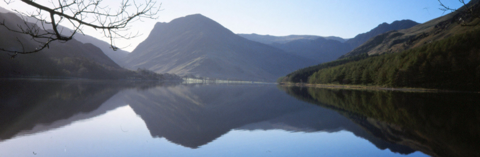 -302. Scale Force from Buttermere
A short evening walk after a stay at Eskmeals.
Right: Buttermere and Fleetwith Pike.
April 2002; NY1716; Buttermere - S,
NW, SW - Scale Force - and back; 4 miles.
-303. From Wasdale to Eskdale
A walk with the Eskmeals group.
April 2002; NY1807; (linear) Wasdale
car park - S past Burnmoor Tarn - Boot; 5 miles.
[To the Largest Natural Tarn in the Lake District]
-304. Arkholme - Newton - Gressingham
April 2002; SD5869; Loyn Bridge,
Hornby - N by River Lune - Arkholme, Newton - SW - Docker Park, Brown Edge - S, SE -
Storrs Hall - S - Gressingham - E - Loyn Bridge; 11 miles.
[From Motte to Motte: Arkholme to Hornby]
-305. Abbeystead
This was my first 'outrun' for about
ten years, having (tentatively) taken up running again after abandoning the University of Leeds.
April 2002; SD5457; Jubilee Tower - SW,
S on Abbeystead Lane - Abbeystead - E - Stoops Bridge - S - Hawthornthwaite, road - E - Marshaw
Wyre bridge - NW on road past Higher Lee - Jubilee Tower; 8 miles.
 -306. Whernside from Chapel-le-Dale
Not much walking (and no running), at least
not in North-West England, from 1996 to 2001 - too busy in Leeds, etc.
Right: Towards the Howgills from Whernside.
October 2001; SD7478; near Old Hill Inn -
N on Philpin Lane, N - Brunscar, Whernside - and back; 6 miles.
-307. Wansfell from Troutbeck
August 2001; NY4103; Troutbeck - NW on
Nanny Lane, N across The Hundreds - highest point of Wansfell - S - Wansfell Pike - E - Troutbeck; 4 miles.
-308. Fiendsdale
The first walk on the hills after
they had been closed for months because of a foot-and-mouth epidemic.
August 2001; SD6351; P at foot of
Langden Brook - W by Langden Brook - Langden Castle - SW by Fiendsdale Water - Fiendsdale Head - and back; 8 miles.
 -309. Swarth Fell and Wild Boar Fell
Right: Wild Boar Fell.
February 2001; SD7895; Shaw Paddock - W -
Goodham Gill Rigg - NW - Swarth Fell Pike - NW - Swarth Fell - N - Sand Tarn - E - Wild Boar
Fell, cairns on Yoadcomb Scar - SE across Low Soursike and above road - Goodham Gill waterfall -
E - Shaw Paddock; 8 miles.
[On Wild Boar Fell]
-310. Clougha Pike
Clear enough for a view of the Welsh hills.
January 2001; SD5457; Jubilee Tower - W,
NW - Hare Appletree - NW, N - Rowton Brook - E, NE - Clougha Pike - SE, SW - Jubilee Tower; 5 miles.
[Trials on Clougha]
-311. Rawthey Force
Before this date is all pre-CROW Act: it is
too late now to charge me with trespass.
May 2000; SD7197; Rawthey Bridge - SE on
south bank of Rawthey (and waterfalls) - Rawthey Gill Foot - and back; 7 miles.
 -312. High Street from Kirkstone
Right: Haweswater below High Street.
March 2000; NY4008; Kirkstone Pass - NE -
Stony Cove Pike - E - Thornthwaite Crag - NE - High Street - and back; 7 miles.
-313. Ingleborough from Newby Cote
A walk on the slopes of Ingleborough to
see the sunrise on the first day of the new millennium.
January 2000; SD7370; Newby Cote - N -
Little Ingleborough (sunrise about here), Ingleborough - and back; 6 miles.
-314. The Whinfell ridge and Borrowdale
A walk that was shortened by descending
Mabbin Crag on bottoms over bilberry.
July 1999; NY6001; Low Borrowbridge -
W, SW - Repeater Station - W - Whinfell Beacon - N - Castle Fell - NW - Mabbin Crag -
NE - Borrow Beck - E - Low Borrowbridge; 7 miles.
 -315. Great Knoutberry Hill
Right: Great Knoutberry Hill trig point.
April 1999; SD7785; Stone House Bridge - E
along Arten Gill, N - Great Knoutberry Hill - W - Green Bank - S on track and over
Stonehouse Brow - W - Stone House Bridge; 5 miles.
[What’s Great about Great Knoutberry Hill]
-316. Sharp Edge and Blencathra
A man in a powered-glider thing accompanied us.
August 1998; NY3130; Threlkeld - N, NE -
Mousthwaite Comb - N, NW, along Sharp Edge - Atkinson Pike - S - Blencathra - SW - Blease Fell -
E - Threlkeld; 8 miles.
-317. Barbon Fell
February 1998; SD6282; Barbon - N, E, NE -
Castle Knott, Calf Top, Barkin Top - SE, SW along valley - Barbon; 6 miles.
[Back in Barbondale]
 -318. Pen-y-ghent
A Boxing Day walk.
Right: Pen-y-ghent.
December 1997; SD8072; Horton - E, N -
Pen-y-ghent - N, W, SW - Horton; 6 miles.
[The Standard Pen-y-ghent Walk]
-319. Ingleborough from Chapel-le-Dale
November 1997; SD7477; near Old Hill Inn -
S - Braithwaite Wife Hole, Ingleborough - and back; 6 miles.
 -320. Place Fell
Right: Ullswater from Sandwick.
May 1997; NY4013; P near Brothers Water -
E, N, NE - Angletarn Pikes - N - Place Fell - NE - Sandwick - S, SW along Boredale -
Boredale Hause - S - P; 11 miles.
[From Pooley Bridge to Glenridding on the Ullswater Way (Eastern Half)]
-321. Whernside from Kingsdale
May 1997; SD7179; Kingsdale Head - N along
road, through Deepdale - Dales High Way - E, S - Whernside - SW - Kingsdale Head; 10 miles.
-322. The Ingleton Waterfalls
April 1997; SD6973; P in Ingleton - N -
Thornton Force - SE - Beezleys - SW - P; 5 miles.
-323. Middle Roeburndale
April 1997; SD5862; cattle grid - SE - Mallowdale -
N - Barkin Bridge - W - Winder Wood - S - Winder - W - cattle grid; 5 miles.
-324. Harter Fell (Mardale)
A rather bold Boxing Day walk in snow and ice.
December 1996; NY4610; Mardale Head -
S up Gatescarth Pass - Adam Seat - NW, SW - Harter Fell - W, NE on Nan Bield Pass; 4 miles.
 -325. Skiddaw
A walk on Ruth's birthday.
Right: Blencathra from Skiddaw
October 1995; NY2329; Ravenstone -
NE, S - Ullock Pike - SE - Carl Side - NE - Skiddaw - and back; 6 miles.
 -326. Scafell Pike
A walk to mark my 50th birthday.
Right: Us on Scafell Pike.
July 1995; NY1807; car-park - E by
Lingmell Gill - Mickeldore, Scafell Pike - N - Lingmell Col - SW, W - car-park; 6 miles.
-327. Bowfell
May 1995; NY2806; Dungeon Ghyll - W -
Stool End, Bowfell - and back; 7 miles.
-328. Ingleborough
A Boxing Day social run.
December 1994; SD7072; Tony’s - NE -
Ingleborough - SW, W - road - Tony’s; 7 miles.
-329. Helm Crag
March 1994; NY3307; Grasmere - N - Helm Crag - and back; 7 miles.
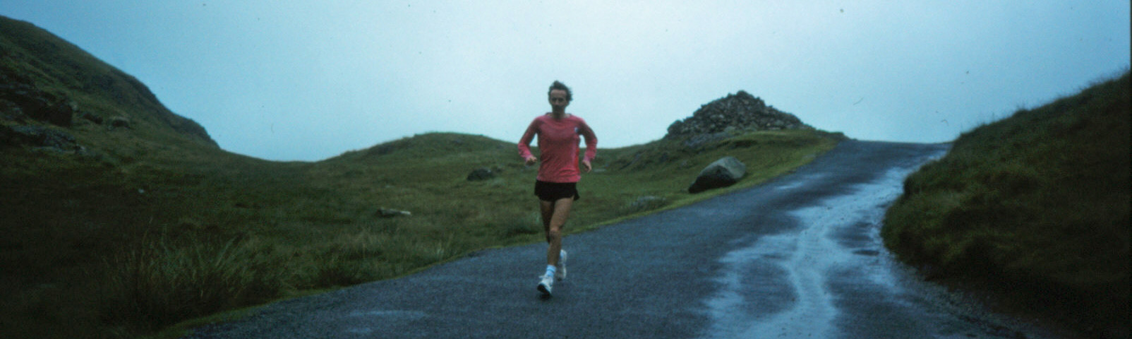 -330. Cockley Beck Bridge to St Bees
Day 6 of a 200-mile coast-to-coast run
from Flamborough lighthouse to St Bees lighthouse. We had camped off-road in the Duddon valley.
I floundered around Sellefield as my map was out of date.
Right: Over the Hardknott Pass.
July 1993; NY2402; (linear) Cockley Beck
Bridge - W over Hardknott Pass - Dalegarth station (toilet stop), Eskdale Green, Santon Bridge -
NW - Gosforth, Calder Bridge - SW, NW - Beckermet - W -
coast road - NW - St Bees beach, St Bees Head, lighthouse; 25 miles.
-331. Low Borrow Bridge to Cockley Beck Bridge
Day 5 of the 200-mile coast-to-coast run.
The previous four days consisted of four roughly 9-mile runs separated by coffee, lunch and tea
breaks but on this day, because of the logistics of meeting up and the heavy rain, it was three
legs: 7 miles (coffee), 11 miles (lunch), 13 miles.
July 1993; NY6001; (linear) Low Borrow
Bridge - W through Borrowdale - A6 - S - layby above Garnett
Bridge (coffee) - NW along Longsleddale - Till’s Hole - W - Stile End (heavy rain) - W, SW - Kentmere -
W over Garburn Pass - A592 (lunch) - E - High Skelghyll, Ambleside - W on Clappersgate back road -
Skelwith Fold, Skelwith Bridge - SW on A593, W through Little Langdale - Fell Foot, Wrynose Pass,
Cockley Beck Bridge; 31 miles.
 -332. Low Whita, Swaledale to Low Borrow Bridge
Day 4 of the 200-mile coast-to-coast run, after camping in Reeth.
Right: At the highest point of the run.
July 1993; SE0098; (linear) Low Whita - W on
road (in light drizzle) - Low Row, Gunnerside, Muker, Thwaite, Hoggarths (coffee) - NW up Birkdale,
over highest point (518m) of run - Nateby - SW on A685 - junction with A683 (lunch at Leases) -
W - Newbiggin-on-Lune, Gaisgill (tea) - W - Tebay - S - Low Borrow Bridge; 36 miles.
-333. Knayton to Low Whita, Swaledale
Day 3 of the 200-mile coast-to-coast run.
The first 2˝ days of the coast-to-coast run are outside my defined North-West England and so
shouldn’t be included here - but they are, for completeness.
July 1993; SE4388; (linear) Knayton - W -
Lowfield House, Thornton-le-Moor - SW - South Otterington, Low Swainby - NW - Allerthorpe Hall,
Gatenby - SW - Theakston (coffee) - NW - Bedale - NW, W - Newton-le-Willows - N - Diamond
Hill farm (lunch) - W, N through East Hauxwell, W - Dykes House - NW - Stainton (tea) - NW, W -
Grinton, Low Whita; 36 miles.
-334. Low Marishes to Knayton
Day 2 of the 200-mile coast-to-coast run.
July 1993; SE8177; (linear) Low Marishes -
W - Costa Farm, Shortten Hall - NW - Great Barugh, Brawby - NW - Sparrow Hall (coffee) - NW, S,
W - Harome, Helmsley (lunch) - W past Rievaulx Abbey - N, W - Old Byland - W, N - Hesketh
Grange (tea) - W down steep Speck Yate Bank - Boltby, Kirby Knowle, Knayton; 36 miles.
 -335. Flamborough Head to Low Marishes
Day 1 of the 200-mile coast-to-coast run.
Right: Flamborough Head.
July 1993; TA2570; (linear) Flamborough
Head lighthouse - W - Flamborough - NW - Bempton - W - Grindale (coffee) - W - Burton Fleming,
Wold Newton, Foxholes (lunch) - NW, W on Wolds Way - West Heslerton (tea) - N - Yedingham - Low Marishes; 36 miles.
-336. Around Bowland
This was a practice run to test out
the planned 4 x 9-mile runs for a day of the coast-to-coast run.
July 1993; SD5457; (linear) Jubilee Tower -
SE through Trough of Bowland - P at Langden Brook (coffee) - SE, S, W - Chipping (lunch) - W -
Tootle Hall - N - Grizedale Bridge (tea) - N, E - Yates Farm - N - Abbeystead; 36 miles.
[Beyond the Leagram Pale]
-337. Around Coniston Water
My last long road race.
April 1993; SD3097; Coniston school -
S - Torver, Water Yeat - E - Arklid Farm - N - How Head - N, W - Coniston; 14 miles (83 minutes, 55th).
-338. Hoddlesden Moss
It was much too boggy to run on
Grey Stone Hill, so I ran rather aimlessly in the other direction.
October 1992; SD7224; near Daisy Green
Reservoir (no longer there) - SE - PH - S - Lark Hill Farm - S, E towards Grey Stone Hill - S -
Scotland Reservoir, road - N on road - Waterside - SE - Hoddlesden - N - Daisy Green Reservoir; 7 miles.
-339. The Tongue, Troutbeck
September 1992; SD4299; N along Borrans
Lane - Borrans Reservoir - W - Dubbs Road - N - Garburn Road - SW, N - Ing - N, W -
The Tongue top - W, S - Troutbeck Park - S on Longmire Road - E - Latrigg Tarn, Dubbs
Reservoir - S, SE - end of Borrans Lane; 11 miles.
-340. Great Coum
June 1992; SD6681; Bullpot - W, NW -
Crag Hill - W - Great Coum - S - Green Hill, Gragareth - SW, W, S - Castle Hill - N -
Bullpot; 12 miles.
-341. High Raise and Ullscarf
May 1992; NY3211; Dunmail Raise - W -
Steel Fell - W, SW - Calf Crag, High Raise (762m) - N on Greenup Edge - Ullscarf (726m) - E -
Wythburn, Steel End - S - Dunmail Raise; 10 miles.
-342. Pendle
This was a clear, frosty day with views of the Three Peaks
and a hot air balloon.
January 1992; SD7738; Nick of Pendle - NE -
Black Hill - N, NE - Pendle top - NE, SE - Pendle House -
S - Ogden Reservoir - S, W - Spence Moor - SW - Churn Clough Reservoir - W - Nick of Pendle; 9 miles.
[On the Sunny Side of Pendle]
-343. Bleasdale
I detoured to look at Bleasdale Circle
but it wasn't really there, with the original wood having been replaced by concrete. The
packhorse bridge at Brooks was more impressive.
October 1991; SD5347; Oakenclough - SE -
Stang Yule - E - Bleasdale Tower - NE - Hazelhurst - E - Holme House - S - Bleasdale school
- W - Brooks - W - Stang Yule - SW - Calder Vale - S, N, W - Strickens Lane - N, W, N -
Birks Farm - N, NW past Barnacre and Grizedale Lea Reservoirs - Calder Side - S - Oakenclough; 11 miles.
[Up Hazelhurst Fell in the New National Landscape]
-344. Wansfell and Harrop Tarn
Two short walks around Ruth’s birthday.
October 1991; NY3704; Ambleside - E - Wansfell
Pike - and back; P near Thirlmere - W - Harrop Tarn - loop via Brown Rigg; 6 miles.
-345. Gurnal Dubs and Todd Fell
October 1991; SD5298; Garnett Plain -
W, N, SW - East View - W - Gurnal Dubs - SW - Ghyll Pool - N - around Potter Tarn -
NE above Gurnal Dubs and past Taggleshaws (just marshes) - Ulgraves - N - Nether House
farm - S, E, N - Murthwaite - N - Todd Fell - SE below Whiteside Pike - A6 - S - Garnett Plain; 9 miles.
-346. Little Whernside and Scar House Reservoir
An ambitious run! That is, it was long,
muddy and tiring.
October 1991; SD9875; near Tor Dyke -
NE across Hem Gill Shaw (wet underfoot) - NE along ridge - Little Whernside (604m), Dead
Man’s Hill (rough going), Coverdale Tarn, Great Haw - E - Little Haw - S - track - W -
Scar House Reservoir - SW - Angram Reservoir - N, W across Angram Pasture - W over ridge - Tor Dyke; 15 miles.
-347. Crosby Ravensworth Fell
A windy day, with rainbows. I couldn't
get to the top of Coalpit Hill because of grouse-shooters.
September 1991; NY5717; near Windrigg Hill
- SE - Wintertarn - S - Castlehowe Scar - E past stone circle, S -
Oddendale - S past Seal Howe - Coalpit Hill - N by
Roman road, Ewe Close, NE on Slack Randy - Holme Bridge - N by Lyvennet Beck - Crosby Ravensworth -
N - Maulds Meaburn, Dairy Bridge - W, N on Morland Bank, SW - Reagill - NW - Sleagill -
SW near Windrigg Hill; 15 miles.
[Remeandering the Lyvennet]
-348. Duddon Valley
September 1991; SD1992; P by the Duddon -
S - Stonescar - SE - Pickthall Ground - E - Broughton Mills - NE - Hawk Bridge - N -
Stephenson Ground - SW - Knott End - N past Stickle Pike - Hall Bridge over Duddon - SW -
Ulpha - S - P by the Duddon; 14 miles.
-349. Whitsun Dale and East and West Stonesdale
This was to have been day 2 of a week of
running but I had too many aches and too little energy to continue.
September 1991; NY8701; High Bridge -
NW - Ravenseat - SW, W, S - Birkdale Tarn - E by River Swale - High
Bridge (drink and rest) - SW - Angram - N - Keld, East Stonesdale - N on Pennine Way -
Haw Shaws - S - West Stonesdale - W - Smithy Holme - E - road - W - High Bridge; 14 miles.
[Around the Kisdon Triangle: Muker, Keld and Thwaite]
-350. Thirlmere
The second run of day 1 of an intended
week of running but I was too tired to run far.
September 1991; NY3212; Wythburn - N on
path through wood - Launchy Gill - S on road - Wythburn; 5 miles.
[Zipping over or around Thirlmere]
-351. Glaramara and Allen Crags
The first run of day 1 of an intended
week of running - good views of Great Gable and Sprinkling Tarn.
September 1991; NY2413; Seatoller -
E - Strands Bridge - SE, S, E - Bessyboot - S past Tarn at Leaves, Rosthwaite Cam, Combe Door -
SW - Glaramara (783m) - S past Lincomb Tarns - Allen Crags (785m) - S, NW, S by Grains
Gill - Seathwaite, Seatoller; 9 miles.
-352. Bolton Priory
The intended run on Simon’s Seat had
to be aborted because the moor was closed for grouse-shooting.
September 1991; SE0557; Barden Bridge -
N on Dales Way - Howgill (moor closed) - S - Barden Bridge - SE on W bank of the Wharfe -
Wooden Bridge - S on east bank - Waterfall Bridge, Bolton Priory - N on west bank -
Wooden Bridge - NW on east bank - Barden Tower; 10 miles.
-353. Skiddaw from the north
August 1991; NY2432; Peter House Farm -
SE on Cumbria Way - Whitewater Dash - SE by Birkett Edge - Bakestall - S by fence -
Skiddaw (931m) - S, E over Sale How - Skiddaw House - N, NE - Peter House; 9 miles.
[Viewpoints around Keswick (part 2)]
-354. Simon’s Seat, Howgills
After parking at Gaisgill, I accidentally
locked myself out of the car. I had to run (in my
running gear) to
Tebay Garage to persuade a mechanic to come to break into the car, which he did rather too easily.
So I was late setting off on the planned run, which meant that it is was getting quite dark,
turning to rain, by the end.
July 1991; NY6305; Gaisgill - S - Gill Hole,
Eller Gill - E below Udale End - S -
Hand Lake - NE - Middleton - SE - Simon’s Seat (587m) - N -
Nevygill Fold - NW, N, NW on Cowbound Lanee - Longdale, Gaisgill; 10 miles.
-355. Winterburn Reservoir and Weets Top
July 1991; SD9057; a mile south of
Airton - E over Newfield Bridge - SE - New Laithe - N - Winterburn, Way Gill, top of reservoir -
NW - Weets Top - S over Calton Moor - Calton - W - Airton - S - one mile south of Airton; 12 miles.
[To the Point of Winterburn Reservoir]
-356. Sunbiggin Tarn
January 1991; NY6208; east Orton -
E, N on Knott Lane - stone circle - E - Acres - NE - Sunbiggin - SE - Sunbiggin Tarn -
NE past Spear Pots - Middle Busk - E - Little Asby Scar - S - Mazon Wath, Rayseat (long cairn),
Dales High Way - W - Grimesmoor Bridge, Raisbeck, Orton; 13 miles.
[Pink Stones on the Orton Fells]
-357. Hopegill Head and Grasmoor
September 1990; NY1520; Lanthwaite
Green - NE - Whin Ben, Whiteside - E - Hopegill Head (770m) - S - Crag Hill (839m) - SW -
Wandope - NW - Grasmoor (852m) - S, SW - Lad Hows - W - Cinderdale Common - N - Lanthwaite Green; 8 miles.
-358. High Street and Loadpot Hill
I saw nobody after Rampsgill Head
until nearing Pooley Bridge when I met R & P (who had tipped me out at Kirkstone)
walking up (with no drink for me, despite
it being a hot day).
July 1990; NY4008; (linear) Kirkstone Pass -
E, NE - Stony Cove Pike - Thornthwaite Crag - NE - High Street (828m) - N - Rampsgill Head
(detour to Kidsty Pike for views) - N - High Raise, Wether Hill,
Loadpot Hill, Arthur’s Pike - NE - The Cockpit - NW - Pooley Bridge; 14 miles.
[From Bampton Grange to the Lake District's Highest Hills]
-359. Slight Side from Eskdale
July 1990; NY1700; Dalegarth station -
S - River Esk - E - Doctor Bridge, Whahouse Bridge - W (a little), N (a lot) - Slight
Side (748m, cloud on Sca Fell) - SW - Quagrigg Moss, Great How - S - Stony Tarn - SW -
Eel Tarn (sank in bog), Boot, Dalegarth station; 9 miles.
-360. Fair Snape and Fiendsdale
June 1990; SD5944; Fell Foot - N -
Parlick (left M here gliding), Fair Snape (510m), Fiendsdale Head - NW by Fiendsdale
Water - Langden Castle - S by Bleadale Water (rough going), W towards Fair Snape, S -
Parlick, Fell Foot; 10 miles.
[Fair Snape: the Fairest Fell of Bowland]
-361. Great Yarlside
I foolishly wore new shoes - and
of course had blisters by the end. Saw two red deer but no people.
June 1990; NY5506; A6 - W, SW - High House
Bank - NW - Robin Hood, Lord’s Seat - N - Crookdale Fold - NE - Great Yarlside (585m) - SE -
Little Yarlside - N - Wasdale Pike - SE - Hazel Bank - S - Whatshaw Common - E -
A6; 9 miles.
-362. Dunnerdale Fells
I broke the handbrake when parking.
May 1990; SD2390; near Baskell - W -
Hobkin Ground, Broughton Mills - NW - Great Stickle - N - Stickle Pike - NE - Brown Haw,
Caw (529m) - E north of forest (rough going) and quarry - High Pike Haw - SE - Banks - S -
road - SW on road - Baskell; 10 miles.
[Broughton Moor, or What's Left of It]
-363. Wild Boar Fell
An evening run after a hot day.
There were gypsy caravans on Birkett Common. After Sand Tarn it was long, rough and tiring going.
May 1990; NY7707; Croglam - S -
Halfpenny House, Wharton Hall, Lammerside Castle, Birkett Common,
Greenlaw Rigg, Little Fell, The Nab, Wild Boar Fell (708m) - W - Sand Tarn - N -
Wharton Fell - W, N on A683, NE on A685 - Croglam; 13 miles.
-364. Great Calva and Knott
April 1990; NY2635; Longlands - NE,
S - Longlands Fell, Lowthwaite Fell - SE - Broad Moss, Little Sca Fell - SW - Meal Fell -
SE past Trusmadoor - Great Cockup - S - White Hause - SE - Little Calva, Great Calva -
NW, NE - Knott - N - Great Sca Fell, Brae Fell - NW - Charleton Wath - SW - Longlands; 11 miles.
[Knott Alone in the Caldbeck Fells]
-365. Lambrigg Fell, Benson Knott and Lily Mere
April 1990; SD5993; by M6 exit - W,
N on Lambrigg Fell, NW - Haygarth - SW - Myers - NW - The Slough - W - Dockergarths
Plantation - S - Benson Knott - S past Fisher Tarn Reservoir - E, S, E - New Hutton - SE -
Ewe Bank Farm - E over M6, NE past Killington Reservoir, past Lily Mere - NW on A684 -
by M6 exit; 12 miles.
[The Lambrigg and Killington Turbines: Why Bother?]
-366. Grayrigg
At Cockin I was ordered to walk not run
otherwise the rams would be after me!
April 1990; SD5397; Otter Bank - S, E -
Chester Hag - NE - Garnett Folds, New House - E past Black Moss Tarn - Biglands - N over
Patton Bridge, past Whinfell Tarn - Howestone - E, N - Craketrees - E - Cockin - SE, NE - Repeater
station - SE over Grayrigg Forest - Grayrigg Pike - E - A685 - SW on road - Grayrigg - W -
Shaw End - W past Black Moss Tarn - W, SW - Littlemire - NW, SW, N past Skelsmergh Tarn - Otter Bank; 15 miles.
-367. Mallowdale Pike
I had to shelter from stinging hail behind the cairn on
Mallowdale Pike and again at High Stephens Head.
March 1990; SD5464; Brookhouse - SE,
E by Traitor’s Gill - S over Greenholes Beck - E on road, S over Bladder Stones Beck -
Haylot Fell - SE - Mallowdale Pike - W - High
Stephens Head - NW - Gallows Hill, Close Flat Plantation, Littledale Hall - W, NW - Brookhouse; 12 miles.
[The Phantom Hills of Mallowdale Pike, High Stephen's Head and Gallows Hill]
-368. Uldale Head and Blease Fell
I saw fell ponies but no people.
March 1990; NY6305; Gaisgill - S -
Ellergill, Peatmire Hill, Rispa Pike, Uldale Head (520m) - N below Rispa Pike -
Whitefold Moss - NW - Roger Howe - S - Powson Knott, Blease Fell (474m) - NE -
Hare Shaw - N - Knott, Weather Hill, Gill Hole, Gaisgill; 11 miles.
[Damming the Howgills]
-369. Malham Cove and Malham Tarn
January 1990; SD8766; Streets - SE on road -
Malham (nearly) - N - Malham Cove - E around cove - Sheriff Hill, Gordale Bridge (viewing Janet’s Foss
and Gordale Scar) - E on Hawthorns Lane, N - Middle Laithe, Mastiles Lane - W over Roman camp -
Seaty Hill, Street Gate - NW - Malham Tarn - W, S around tarn - Streets; 11 miles.
-370. The Fairfield Horseshoe
December 1989; NY3704; Ambleside - NW -
Rydal Park, Rydal Hall, Nab Scar - N - Heron Pike, Great Rigg, Fairfield (nobody here) - SE -
Hart Crag, Dove Crag - S - High Pike, Low Pike, Low Sweden Bridge, Ambleside; 10 miles.
-371. Bram Rigg and Black Force
November 1989; SD6395; Four Lane
Ends - E - Castley, Bram Rigg, Bram Rigg Top - N - The Calf - NW - White Fell Head,
Bush Howe, Breaks Head - N - Wind Scarth - NW - Over Sale, Docker Knott - W - Blakethwaite
Bottom - S above Black Force, SW - Whins End - S, W - Beck House, Gate House - S - Four
Lane Ends; 10 miles.
-372. Dodd Fell from Hawes
November 1989; SD8789; Hawes - SW on
Gaudy Lane, West Cam Road - west of Dodd Fell - E - Dodd Fell - S - road at Kidhow - NE -
Wether Fell, Burtersett - W across fields - Gayle - N - Hawes; 13 miles.
[From Hawes, in the Poet Laureate's Footsteps]
-373. Around Haweswater
October 1989; NY4116; Naddle Gate -
W, SW - Mardale Head - NE on road - Naddle Gate; 10 miles.
-374. The Kentmere Horseshoe
August 1989; NY4504; Kentmere church -
W on Garburn Pass, N - Yoke, Ill Bell, Froswick, High Street - SE - Mardale Ill Bell,
Harter Fell - S, SE - Kentmere Pike, Goat Scar - S - Shipman Knotts, Wray Crag - SW -
Stile End, Kentmere church; 12 miles.
-375. To Hornby and back
July 1989; SD5464; Brookhouse - NE -
Bull Beck Bridge - NE by Lune, SE - Claughton - NE on road - Hornby Bridge - W by Wenning,
NE by Lune - Loyn Bridge - SW by Lune - The Snab, Burton Wood,
Crook o’Lune - NE by Lune - Waterworks Bridge - S - Brookhouse; 13 miles.
[Tracking the Thirlmere Aqueduct]
-376. Sunderland Point
July 1989; SD4364; Moreecambe
skateboard ramp (left M there) - SE on cycleway, SW - Snatchems, Overton, Sunderland Point - N, NW -
Potts Corner - NE - Middleton, Snatchems - and back; 16 miles.
[Over to Overton and Around Little Fylde]
-377. Around Bannisdale to Harrop Pike
June 1989; NY5406; near Forest Hall -
W - Thorn Cottage - SW - Plough Farm, Mosergh Farm - N - Whiteside Pike, Cappelbarrow,
Mere Crag - NW - Grey Crag - NE - Harrop Pike - SE over Borrowdale Moss - White Howe,
The Forest - W - Nab End - S on road - near Forest Hall; 14 miles.
-378. Whitendale
May 1989; SD6952; near Laythams -
NW - Burnside Cottage, Dunsop Head - W - Whitendale - S, SW, NW - Brennand Farm - NE -
Whitendale - N by Whitendale River - Roman road - SE - Higher Wood House - S - Laythams; 12 miles.
-379. Whernside
May 1989; SD6975; above Raven Ray -
N, SE - Twisleton Scar End - NE - West Fell, Combe Scar, Whernside (736m) - N - Knoutberry
Hill, Whernside Tarns - S, SW - Cluntering Gill Bridge - S - Raven Ray; 15 miles.
-380. Whinfell Beacon and Roundthwaite Common
May 1989; NY6006; Low Borrow Bridge -
W up Borrowdale, SW - repeater station - NW - Whinfell Beacon, Shooter Howe, Castle Fell,
Mabbin Crag, Ashstead Fell, A6 - NE up Breasthigh Road, SE - Whinash, Winterscleugh,
Roundthwaite Common, Belt Howe, Castlefell Hill - Low Borrow Bridge; 12 miles.
-381. Clougha Pike
May 1989; SD5464; Brookhouse - SE -
Belhill Farm - SW, S - Clougha Pike - NW - path above Rigg Lane - NE - Bark Barn - E -
The Cragg - NE, NW - Brookhouse; 12 miles.
[An Advent Adventure on Baines Cragg]
-382. Ribblehead
In sleet, with fresh snow on the Three Peaks down to about 400m.
April 1989; SD7678; S of Ribblehead Viaduct -
SW on Low Sleights Road - E - Colt Park - S, SE - Selside, Horton-in-Ribblesdale -
N on Pennine Way - Birkwith Moor - W - Old Ing - N - Ling Gill Bridge, Cam End - W, SW - Gearstones,
S of Ribblehead Viaduct; 15 miles.
[Upper Ribblesdale: Drumlins, Three Peaks and a Cave]
-383. Great and Little Langdale
April 1989; NY3506; P by Rydal Water - SW -
High Close - W - Walthwaite, Chapel Stile - W on track south of Great Langdale Beck, SE -
Bleatarn House - S, E - Busk House, Dale End - NW - Elterwater Hall, Oaks - P by Rydal Water; 13 miles.
[Lingmoor Fell - For the Best Medium-High View in Lakeland?]
-384. Ward’s Stone
March 1989; SD5458; Jubilee Tower -
SE - Lower Lee - NE - Tarnbrook - E, NE - Brown Sike - NW, W - Grey Crag, Ward’s Stone,
Grit Fell, Clougha Pike - S over Hare Appletree Fell - Jubilee Tower; 13 miles.
-385. Abbeystead and Dolphinholme
This was in a very cold wind, with hail at one stage.
February 1989; SD5153; near Fleece Inn
- SE - Street, Bracken Lea - NE, SE - Yates - SE, NE - Well Brook - NW -
Higher Emmetts - W - Abbeystead, Dolphinholme - SW - near Fleece Inn; 13 miles.
[A Lowland Bowland Walk from Dolphinholme]
-386. Claife Heights and Grizedale, around Esthwaite Water
January 1989; SD3695; P at south end of
Esthwaite Water - SE, NE - Near Sawrey - N - Moss Eccles Tarn, Wise Een Tarn, Long Height -
W - Hawkshead - S - Roger Ground - SE, S, SW - High Barn - S, SW - Grizedale - S - Satterthwaite -
NE through wood, N on road, SE - P by Esthwaite Water; 12 miles.
[Pottering about Near Sawrey]
-387. Littledale and Caton Moor
January 1989; SD5464; Brookhouse - SE -
Udale Bridge, Field Head - NE, E - Haylot Farm - N - Barkin
Bridge, Thornbush - SW - Caton Moor trig point - W on Quarry Road - Brookhouse; 12 miles.
[The Moor the Merrier]
-388. Upper Eden and Ure Valley
It was cloudy or misty with snow on
the ground. The early farmsteads were all derelict apart from Blades, which was a rather
optimistic restaurant.
November 1988; SD7993;
South Lunds - NE - Blades, High Dyke - NW - High Way, High Hall,
Hell Gill Bridge - N on Old Road (track), on B6259 - Outhgill - S on B6259 -
Aisgill Moor, South Lunds; 13 miles.
-389. Swindale
November 1988; NY5514;
Keld, near Shap - SW - water board road - SE, S - Stackhouse Brow - SW on bridleway - White Crag (Wet
Sleddale below), Mosedale Beck - N over Nabs Moor (8 deer seen) - Swindale Head - NE -
Swindale Foot, water board road - S, E, SE, NE on road - Keld; 12 miles.
-390. Scales Moor to Ribblehead Viaduct
October 1988; SD6975;
above Raven Ray in Kingsdale - SE - Twistleton Scar End - NE - Ewes Top, over Scales Moor,
Ellerbeck, Bruntscar, Broadrake, Ivescar, Winterscales - Ribblehead Viaduct (under repair) -
SW on Low Sleights Road - Chapel-le-Dale - SW on Roman Road - Twistleton Dale House,
Beezleys - NW - Twistleton Hall, Raven Ray; 14 miles.
[Early Spring in Chapel-le-Dale]
-391. Burn Moor and Raven's Castle
Much of this was tough going,
fit only for grouse and grouse-shooters.
October 1988; SD6766;
near Great Stone of Fourstones - S on Slaidburn Road, SE on Petersbottom Lane - Davidson's Crag, Burn Moor
trig point - S - Thistle Hill,
Raven's Castle - W - Cross of Greet - N on Lythe Fell Road, W on Lythe Lane,
N on Silly Lane, Craggs Lane, NE on Ringstones Lane - Great Stone of Fourstones; 11 miles.
-392. Bowderdale and The Calf
I saw two fell ponies on my ridge and
two people on the opposite ridge.
September 1988; NY6805;
Brow Foot - SW - Bowderdale village (about two houses) - S, SW, S - West Fell - S - Hazelgill Knott - S, SW -
The Calf (676m) - NE - Bowderdale Beck - N, E (scramble up) by Great Randy Gill, NE - Green Bell - N- Stwarth -
NE - Weasdale, Cow Bank - N - Gars - N,W - Brow Foot; 13 miles.
-393. The Old Man of Coniston
There was nobody else on the Old Man.
Good views of Coniston Water, Morecambe Bay, other Lakes Peaks, Sellafield, and the Isle of Man (just).
September 1988; SD2894;
Torver - N, NW - Torver Bridge - N -
Goat's Water, Goat's Hawse - SE - The Old Man of Coniston (803m)
- N - Brim Fell, Levers Hawse (could find no path west)
- S, SE - Goat's Hawse - N, SW past Seathwaite Tarn, S on track - near Long House -
E on Walna Scar Road - Torver Bridge - SE - Torver; 13 miles.
-394. Roeburndale, around Caton Moor
September 1988; SD5464;
Brookhouse - NE on road - Caton Green, Claughton - NE, E - Butt Yeats - SE, S past Thornbush -
Barkin Bridge, Lower Salter, ford (under water), Haylot Farm (heavy, driving rain now) -
NW, W on Roeburndale Road, NW on Littledale Road - Brookhouse; 13 miles.
[A Rivetting Tale of High Gimmerdale]
-395. Crummack
Recent heavy rain had left the caravan parks
like paddy fields. Some tracks had to be paddled through.
August 1988; SD7468;
Crina Bottom cemetery - N - Clapham -
E, N on Long Lane past Thwaite Scars, E over Long Scar - Crummack farm - S, SE - Wharfe
- SW - Austwick, Harden Bridge - SW on Orcaber Lane - Lane Side Bridge - NW -
Clapham Station - NE - Crina Bottom cemetery; 12 miles.
-396. Hutton Roof Crags
July 1988; SD5976;
west of Whittington - W - Nanny Hall - W, N - Battle House - N - Hutton Roof -
N, E - road between Newbiggin Crags and Hutton
Roof Crags -SW - Clawthorpe - S - Burton-in-Kendal - E - Dalton - NE through woods of Dalton Crag
- Hutton Roof Crags trig pt (274m) - SE (entangled in gorse, etc.) - Cockshot Hill
- S - Crag House - E - Johnson House, Nanny Hall, west of Whittington; 13 miles.
[Karren and Flora on Hutton Roof Crags]
-397. The Helvellyn ridge
This was the 4th of 5 legs in Charles's
Bob Graham Round. Charles had had enough by Dunmail Raise but he was persuaded back to his feet.
Darkness and drizzle was beginning to fall but by Seat Sandal it was really raining - and windy and
cold as well. I was one of two donkeys to carry anything Charles might need.
We plodded on in this seemingly interminable nightmare until at last the lights of
Keswick came into view. Our navigator never put a foot wrong (except once, only briefly). And yes
Charles completed the 5th leg too.
July 1988; NY3211;
Dunmail Raise - E, SE - Seat Sandal - near Fairfield (I didn't go to the top
of Fairfield but was left standing to mark the optimum point to head for) - N -
Grisedale Tarn - NE - Dollywaggon Pike - N -
Nethermost Pike, Helvellyn, Lower Man, White Side, Raise, Stybarrow Dodd, Watson's Dodd, Great Dodd,
Clough Head, Threlkeld; 14 miles.
-398. Calf Top and Barbondale
June 1988; SD6382;
opposite Barbon Manor (in drizzle) - W - Barbon - N - Eskholme - E - Eskholme Pike (in cloud) - NE - Castle Knott,
Calf Top, Weather Ling Hill - SE - Barbondale road (raining quite hard) - SW - Short Gill Bridge -
SW, W - opposite Barbon Manor; 11 miles.
-399. Around the River Winster, on quiet lanes
May 1988; SD4389;
Town End (east of Bowland Bridge) - S - Pool Bank, High Low Wood,
Middle Low Wood, Low Low Wood (uninspired naming here), Bleacrag Bridge - W, N -
Low Tarn Green, High Tarn Green, Thorphinsty Hall, Swallow Mire -
NE - Lobby Bridge, Town End; 10 miles.
-400. Nan Bield and Gatescarth Passes
May 1988; NY4504;
Kentmere Church - E, N - Overend - NW - Smallwaite Knott (Kentmere reservoir nearly empty) -
N past Drygrove Gill - Nan Bield Pass (640m) - NE past Small Water - Haweswater car park - SE - Gatescarth
Pass (567m) - S - Sadgill - W, S, W on old drove road - Stile End - NW, S - Kentmere Church; 13 miles.
[Small Water with Little ‘Uns]
-401. Parlick and Fair Snape
May 1988; SD5944;
Fell Foot - NW - Parlick (432m) - N over Blindhurst Fell, NW - Fair Snape (510m)
- NE - highest point of access area (520m) - NW along fence (tough going) - Fiendsdale Head -
SW, SE - Holme House - S past Bleasdale church and school - Wickens Lane End - E - Fell Foot; 9 miles.
-402. Baugh Fell
Dockholmes was an unexpectedly attractive limestone gorge
but Baugh Fell was desolate and silent (apart from jets). A long, challenging run!
April 1988; SD7197;
Rawthey Bridge - SW, E on path below Bluecaster - SE -
Dockholmes, Rawthey Gill - SW -
Knoutberry Haw (676m) - N - West Baugh Fell Tarn - NW - Taythes Gill - N, W - Bluecaster
Side - N - Rawthey Bridge; 14 miles.
-403. High Street
An escape from a workshop.
April 1988; NY3817;
Ullswater Hotel - SE, E - Patterdale, Side Farm - SE - Boredale Hause, Angle Tarn, Satura Crag,
The Knott - S - Straits of Riggindale, High Street (828m) - SW - Thornthwaite Crag beacon
- W - Threshthwaite Mouth, Stony Cove Pike (763m), Caudale Moor (monument) - NW -
Caudale Bridge - N - Brothers Water Inn - W - Hartsop Hall - N past Brothers Water, Low
Wood - Patterdale, Ullswater Hotel; 15 miles.
-404. High Pike and Scandale
April 1988; NY3704;
Ambleside car park - N - Low Sweden Bridge, Sweden Crag, Low Pike, High Pike,
near Dove Crag (about 770m) - E over Bakestones Moss -
Black Brow - SE - Scandale Pass - SW - Scandale Bottom - S past High Sweden Bridge - Rough Sides,
Ambleside; 10 miles.
[Up Dove Crag in Homage to Wainwright]
-405. Ingleborough from Clapham
I was first to the Clapham car park (it was full-ish
when I returned). There was nobody at the top of Ingleborough.
March 1988; SD7469;
Clapham car park - N along Clapdale Drive (paid 15p), past Ingleborough Cave - Trow Gill -
NW past Gaping Gill - Little Ingleborough - N - Ingleborough (723m, light snow cover) -
NE past steaming peat bogs - Simon Fell (636m) - SW - Ingleborough - S - Little Ingleborough, Newby Moss,
Newby Cote - SE - Clapham car park; 12 miles.
-406. Salter Fell and the Hornby Road
March 1988; SD5862;
above Winder - E, SE - Haylot Farm - N over ford, SE - Middle Salter -
SE on Hornby Road (track) - High Salter, High Salter Close,
Alderstone Bank, Salter Fell, Guide Hill, Old County Gate - NW - High Salter -
SW - Mallowdale - NW - Haylot Farm - NW, W - above Winder; 13 miles.
-407. Dentdale
At this time I was transitioning from
road-running (and road-racing) to running freely on the hills and in the dales.
But I fancied this race in Dentdale - although it turned out to be cold and drizzly with
snow on the hills.
March 1988; SD7087;
Dent campsite - W - Gawthrop - NW - Rash Bridge - SE - Barth Bridge (not over) - E - Gibbs Hall,
Ewegales Bridge - W - Whernside Manor - NW - Dent;
14.5 miles (83 minutes, 14th).
[By the Old Farmhouses of Dentdale]
-408. Longsleddale and Brunt Knott
March 1988; SD5299;
Garnett Plain - W, N - Garnett Bridge - NW past Murthwaite, W - Docker Nook, Brunt Knott (427m) -
SW - Brunt Knott Farm - W, N - High House - W, N below Staveley Head Fell, over Skeggleswater Dike,
N over Birk Rigg -
Green Quarter Fell - NE over Cocklaw Fell, N, E - Till's Howe - E, SE past Swinklebanks -
Murthwaite - SE - Garnett Plain; 15 miles.
[The Longsleddale Green Lane]
-409. Bretherdale and Borrowdale
There was a "Save water.
Save Borrowdale" notice at one gate, a remnant of the recent campaign to prevent Borrowdale becoming a reservoir.
February 1988; NY6001;
Low Borrowbridge - N - Roundthwaite - NW, SW - Bretherdale Hall (just a farm) - W -
Midwath Stead, Bretherdale Head - W - Bretherdale Bank - SW - Huck's Bridge - SE -
High Borrowdale, Low Borrowdale - SW, W - Low Borrowbridge; 14 miles.
[Bretherdale Then and Now]
-410. Cautley Spout and The Calf
January 1988; SD6591;
Sedbergh - E on A683 - Straight Bridge - NE - to cross River Rawthey at
Crook Holme - N - Cautley Beck - NW past Cautley Spout - SW by Red Gill Beck - Bram Rigg
Top - N - The Calf (676m) - S - Calders - SW - Arant Haw, Winder - SW, S - Sedbergh; 13 miles.
-411. Brennand and River Dunsop
January 1988; SD6351;
Trough of Bowland below Sykes Nab - NW - Sykes Farm, Trough Barn - NE - Trough House - E -
Whin Fell ridge - N on Ouster Rake - Brennand Farm - SE by Brennand River -
River Dunsop - S - Bishops House, Dunsop Bridge - NW - Langden Brook -
(bonus bit) - W - Langden Castle (a derelict barn) - E - below Sykes Nab; 13 miles.
[The 1 in 5,000 Hen Harriers of Bowland]
-412. Claughton Circular
A walk with our research group,
ending with tea on our lawn. At that time, there were bison at Claughton Hall.
September 1987; SD5464;
Brookhouse - N - Bull Beck Bridge - NE on south bank of the Lune - Claughton Beck -
SE - Claughton, Claughton Hall - S - Moorcock Hall, picnic spot - W on Quarry Road - Brookhouse
[The Brookhouse - Claughton Circular]
-413. Around Derwent Water
I don't have records of walks before 1987
but I do of the road races I did. These took me (and us) to various parts of the north-west
but I don't have a record of where exactly I ran (I just followed the others). It'd be
tedious to list them all so I'll just mention a few that might be of interest.
This one was a pleasant, if cold and windy, run around Derwent Water, all on road (which
was not so pleasant on the eastern side).
November 1985; NY2623;
Keswick School - W, S - Grange - N - Keswick; 10 miles (56 minutes; 26th).
[Two Sides of Bassenthwaite Lake and One of Derwent Water]
-414. Around Windermere
October 1983; SD3995;
Bowness - N on A593 - Troutbeck Bridge - NW - Waterhead - SW - Clappersgate - S -
Hawkshead - S - Newby Bridge - N - Bowness; 26 miles 365 yards (2 hours 35 minutes; 7th).
[Bowness and its Hinterland]
-415. Preston to Morecambe
The first of seven marathons.
This was along the A6, a little
scary then and not possible today, and then through the Saturday shoppers of Lancaster,
and on to Morecambe.
July 1980; SD5331;
(linear) Preston - N on A6 - Broughton, Barton, Bilsborrow, Garstang, Galgate, Lancaster
- NW over Greyhound Bridge, towards Morecambe - W, NW through West End - coast road
- NE - Midland Hotel; 26 miles 365 yards (2 hours 36 minutes; 19th).
-416. Skiddaw
This was the only serious fell-race I
ran. It was enough to show that I wasn't sufficiently tough, brave and foolish for this
kind of running. I preferred to run smoothly, like Seb Coe (I wish).
July 1980; NY2623;
Keswick - NE, N, NW on the standard route - Skiddaw - and back the same way;
11 miles (74 minutes; 50th).
-417. Windermere to Kendal
This was the first road-race I ran.
A 17-year-old Steve Cram ran too, coming 4th. This race had the added excitement of not
being sure that the level crossing in Staveley wouldn't be closed, thereby stopping the race.
March 1980; SD3995;
Bowness - NE - Windermere railway station - E on A591 (which at that time went through
Staveley), SE - the end was somewhere near Kendal railway station; 10 miles (58 minutes; 127th).
-418. Ingleborough - Pen-y-ghent - Whernside
The only walk before 1980 that I
can definitely date and give details of is the Three Peaks walk of 1973. Obviously there
were walks before that to be able to tackle the Three Peaks.
June 1973; SD7477;
Old Hill Inn, Chapel-le-Dale (which was where Three Peaks walks usually started at that time) -
S - (our ill-disciplined group immediately splintered, some hurrying up Ingleborough, others
taking a more leisurely, longer-term approach) - Ingleborough - E through Sulber -
Horton-in-Ribblesdale - S, E, NE - Pen-y-ghent - (I had a sore knee by this stage) NW (no
clear path in those days) - Ribblehead viaduct - N, NW, W, S - Whernside -
S, SW - Old Hill Inn; 24 miles, 1600 metres ascent.
Home Preamble Index Areas Hills Lakes Dales Places References Me
© John Self, 2018-

Top photo: Rainbow over Kisdon in Swaledale; Bottom photo: Ullswater