
Home
Preamble
Index
Areas
Dales
Hills
Lakes
Places
Reserves
Rivers
Structures
Villages
References
Me
Saunterings: Walking in North-West England
Saunterings is a set of reflections based upon walks around the counties of Cumbria, Lancashire and
North Yorkshire in North-West England
(as defined in the Preamble).
Here is a list of all Saunterings so far.
If you'd like to give a comment, correction or update (all are very welcome) or to
be notified by email when a new item is posted - please send an email to johnselfdrakkar@gmail.com.
This is one of several relatively short items about local walks during the first
coronavirus lockdown, April - May 2020.
87. Around the Claughton Clay Pit
I have mentioned the Claughton Brickworks twice recently so I thought we should go to see how it’s getting on. We
have peered into what the OS map calls a Clay Pit a few times in the past while the workers were beavering
away and it always seemed a little voyeuristic. Now, with the Brickworks closed like so much else, we can investigate
without being intrusive.
We walked up Quarry Road and then along the track that is part of the North Lancashire Bridleway. It is
odd that the moor to the east is not Open Access land. The 1847 OS map shows that it was tree-covered within a Claughton Plantation but today it seems little different to the rest of Claughton Moor and Caton Moor. In fact, as cows and sheep seem no longer to browse here, it has become wilder than most of the moor, with heather and willow trees colonising.
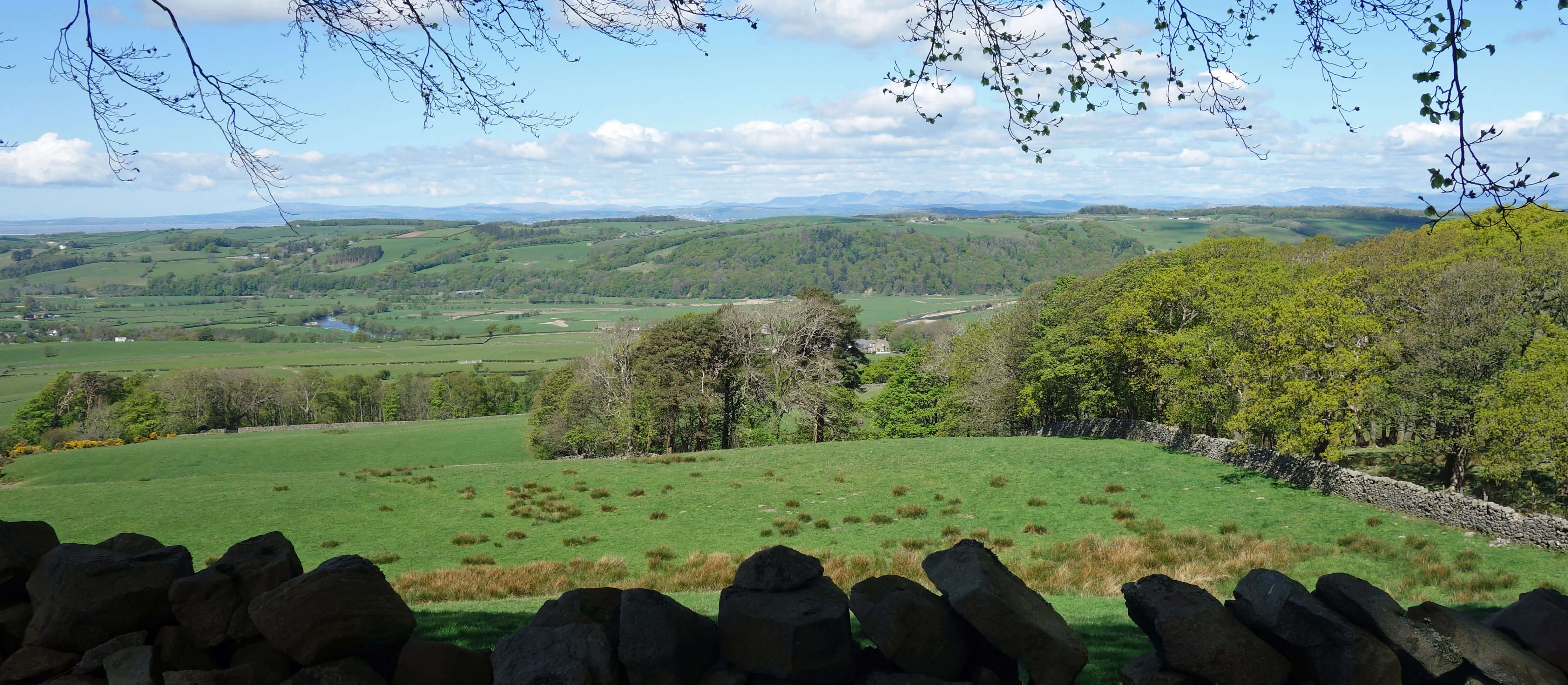
From Quarry Road, looking to the Lake District
Perhaps the owners, who I assume to be the Oystons of Claughton Hall, claimed some special dispensation for
this part of the moor. Maybe they wanted to reserve it for shooting? In recent years a line of boards (they can
hardly be called butts) has appeared on the moor. Thousands of red-legged partridges used to be (and maybe still
are) reared for shooting but perhaps it is hoped that the increased heather will lure some grouse here.
People who consider themselves top-class shoot grouse, therefore if you shoot grouse you
can consider yourself a top-class person. The logical fallacy may be lost on a family in which Owen Oyston was convicted of rape in 1996 and he and his son were in 2017 ordered to repay Ł31 million after the illegitimate stripping of Blackpool Football Club.
At a tumble-down wall we turned left towards the Clay Pit. After a month of walking on lanes, tracks and
paths, we had forgotten what a dubious pleasure it is walking across rough moorland. At least it was not wet, as
it usually is. But in their thirst the moor-grass, sphagnum moss, bilberry and heather seemed to have swelled into
dry sponges. On every step it was impossible to tell how far the foot would sink before reaching solidity.
The
unevenness made for very slow going but we didn’t mind as we saw dozens of small, emerald green butterflies with
delicate dotted markings on the wings, which had a reddish fringe. We are no lepidopterists but these must
surely be green hairstreaks. I hesitate because
Patrick Barkham, who tracked down all British species of butterfly in one year, said
that hairstreaks are “elusive” and that
he “had not seen a green hairstreak for a decade” (Barkham, 2010). On the other hand, the trusty Collins guide to British
insects says that the green hairstreak “flies April-July in a wide range of habitats including
moorland …” and the first of its food-plants listed is bilberry. Our butterflies looked like textbook
examples of the green hairstreak – intense green, smooth, neat streaks – more so than the examples
online
and in actual textbooks – varied yellowish greens, bedraggled, partial streaks.
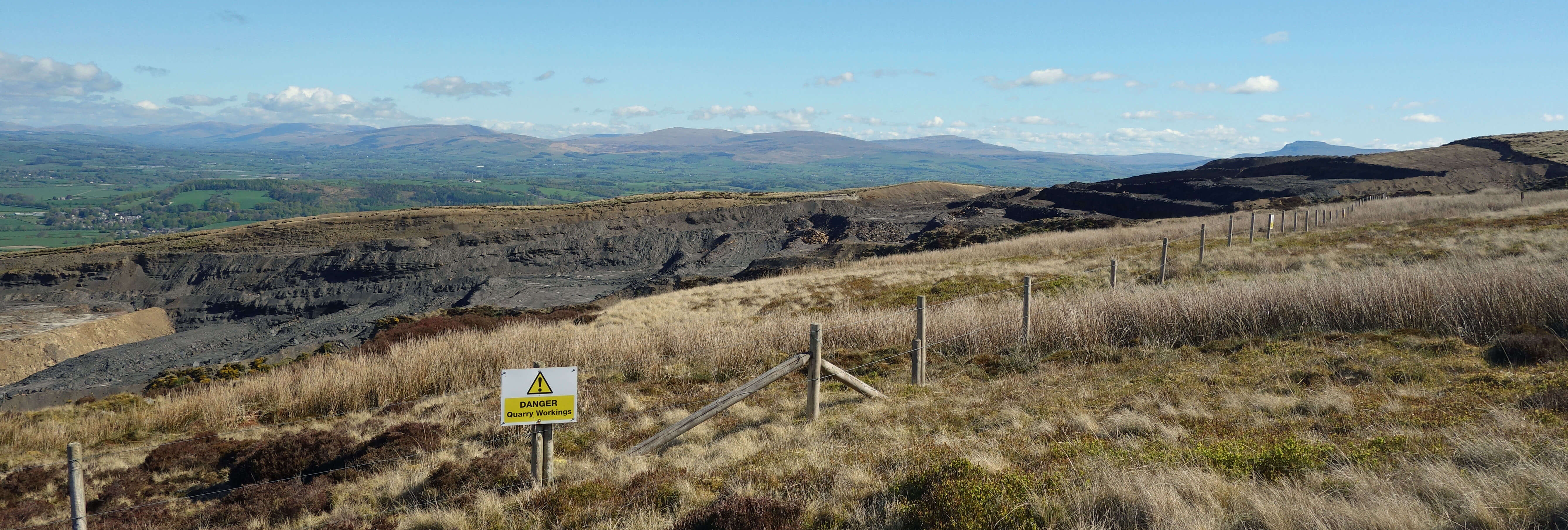
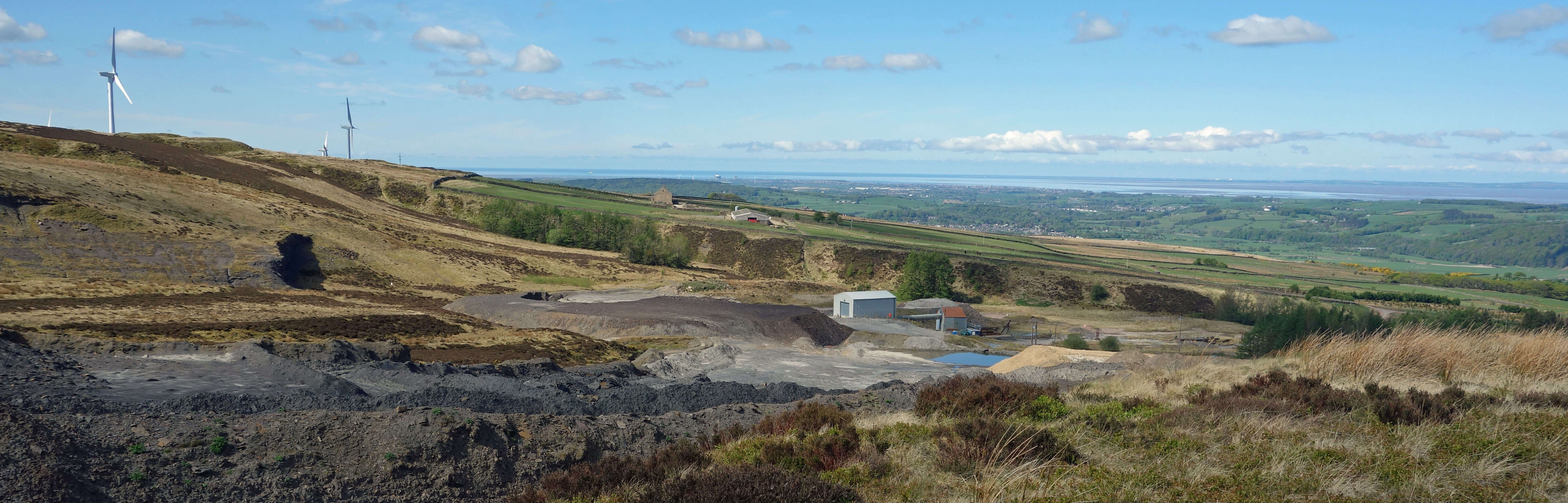
Claughton Clay Pit, looking east to the Yorkshire Dales
We eventually reached the rim of the Clay Pit and looked down into the crater. In 2008 we had joined a
guided tour of the Brickworks and the Clay Pit. On that occasion it was such a gloomy, drizzly day that
everything was a shade of black and we could believe that nothing had changed at the pit since the brickworks began.
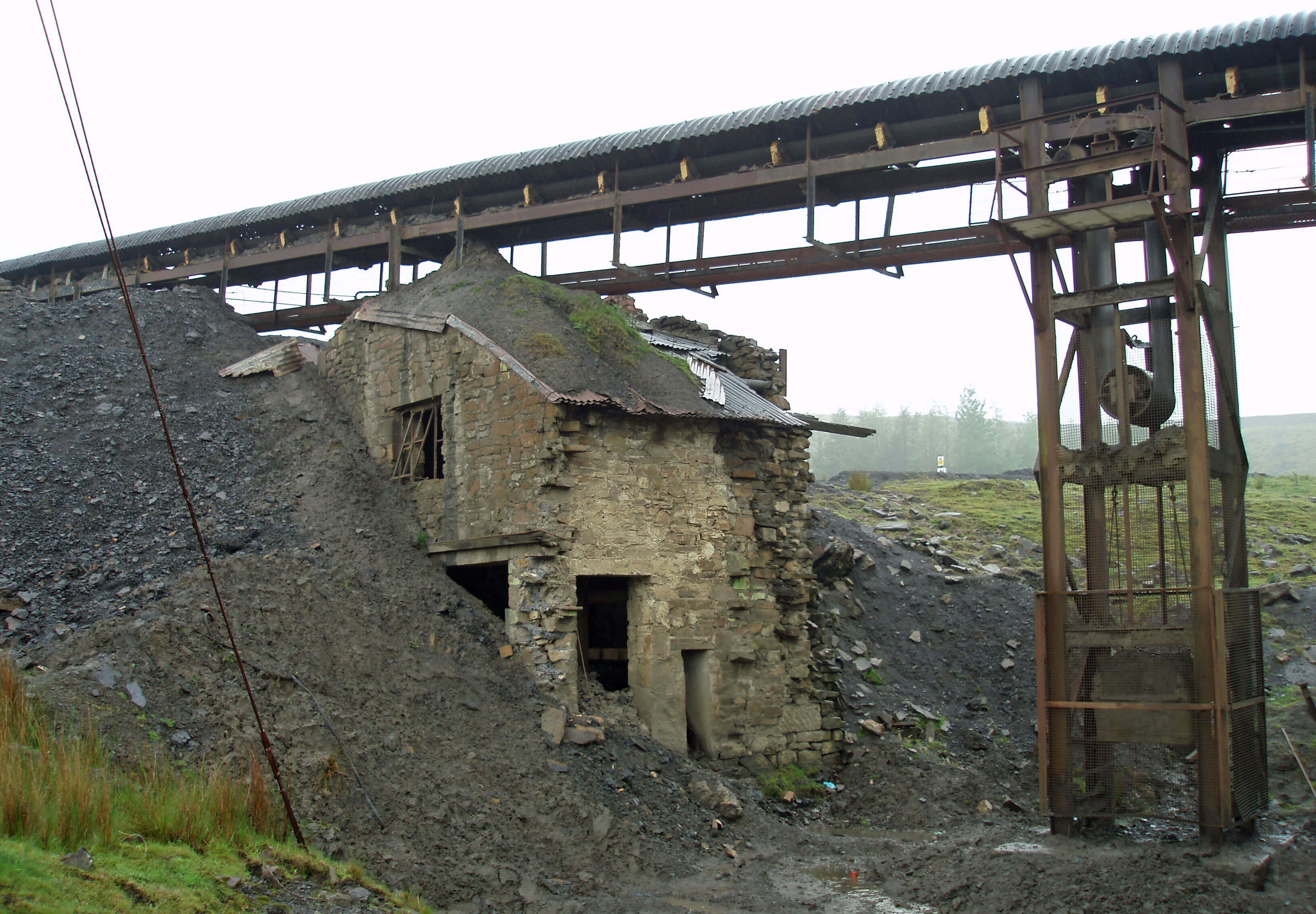
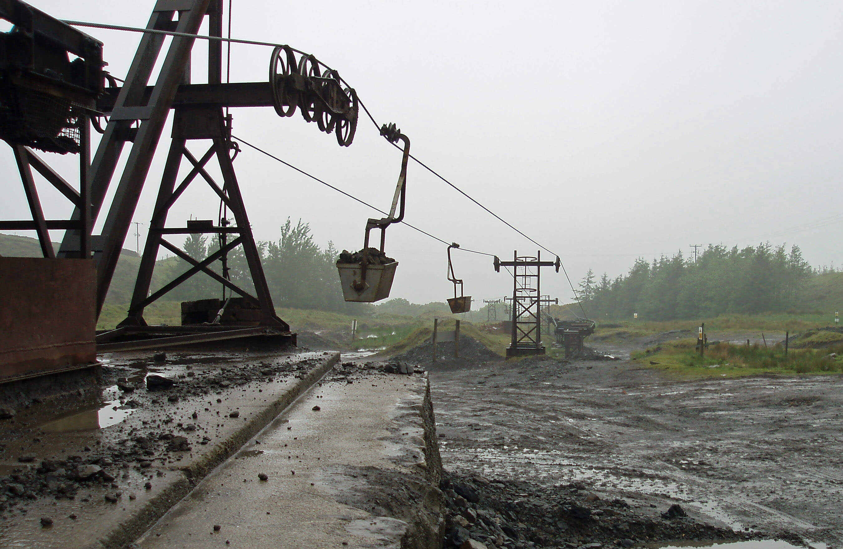
Claughton Clay Pit in action in 2008
Claughton Brickworks was not the first brickworks in the region. From 1874 there was a Clay Pit in
Potter Hills Wood, south of Hole House Farm, with a Lunesdale Brick & Tube Works to the north, near
the present Lunesdale Terrace. This closed in 1901 but the remains of the old tramway can still be seen from the road from Caton Green. The 1895 map marks Claughton Quarries (for sandstone flags, not brick-making) at what’s now the humpy land around the parking spot near the windmills, and marks nothing where the present Clay Pit is. The 1913 map shows two brickworks in Claughton, West End Brick Works and Manor Brick & Tile Works, both with rail tracks linking to the North Western line. The works had an aerial ropeway and a tramway, respectively, linking to quarries a short distance up the hill (with no Clay Pit marked where it is today). Claughton Quarries is marked as disused by 1916. A Clay Pit appears where it is now on the 1956 map, with aerial ropeways to both the Claughton brickworks, the West End part of which closed in the 1970s.
Shortly after our tour the Brickworks was mothballed because of the downturn in house building after the financial crisis. Since then the Brickworks has been revitalised with new investment. On our visit we had the now-customary blue skies, there were no workers toiling in dreary conditions, and there was even a touch of colour in the renovated sheds and aerial ropeway that carries the shale down. The pit itself is larger than shown on the OS map and larger than on our last visit. It now extends further east.
Where will it end? This is not a rhetorical question.
Is all of Claughton Moor suitable for making bricks? The brickworks has permission to continue operating until 2036.
Claughton Clay Pit, looking west towards Morecambe Bay
We had to detour south on yet more rough ground to get around a deep gully (the beginning of Claughton
Beck) before finding a good path on the eastern edge of the pit. From here it was mainly a matter of
enjoying the excellent views: beyond Hornby, to Fountains Fell, Pen-y-Ghent, Ingleborough, Whernside,
Gragareth, Barbon Fell and the Howgills; over the Lune valley, to Shap Fells, Kentmere Pike, Red
Screes, Fairfield, the Langdales, the Coniston Old Man group and Black Combe. It is distressing having
the distant fells flaunt themselves in this tantalising fashion but I will resist them. The tide was out, leaving Morecambe Bay quite empty. We tried to convince ourselves that beyond Barrow we could see the Isle of Man – but we didn’t quite manage it.
Date: April 27th 2020
Start: SD543644, Brookhouse (Map: OL41)
Route: SE, E on Quarry Road – picnic site by windmills – SE on bridleway, N – Clay Pit –
around pit – SW past Moorcock Hall – picnic site – W, NW – Brookhouse
Distance: 6 miles; Ascent: 260 metres
Home
Preamble
Index
Areas
Dales
Hills
Lakes
Places
Reserves
Rivers
Structures
Villages
References
Me
© John Self, 2018-

Top photo: The western Howgills from Dillicar;
Bottom photo: Blencathra from Great Mell Fell