
Home
Preamble
Index
Areas
Dales
Hills
Lakes
Places
Reserves
Rivers
Structures
Villages
References
Me
Saunterings: Walking in North-West England
Saunterings is a set of reflections based upon walks around the counties of Cumbria, Lancashire and
North Yorkshire in North-West England
(as defined in the Preamble).
Here is a list of all Saunterings so far.
If you'd like to give a comment, correction or update (all are very welcome) or to
be notified by email when a new item is posted - please send an email to johnselfdrakkar@gmail.com.
104. From Bampton Grange to the Lake District's Highest Hills
The villages of Bampton Grange and Bampton lie peacefully by the River Lowther (which runs from Wet
Sleddale Reservoir) and Haweswater Beck (which runs from Haweswater Reservoir), tucked between limestone
crags to the east and the slopes up to the High Street ridge to the west.
They are pleasant, rather isolated, villages now but were more important when
the nearby Shap Abbey
was flourishing, that is, between the 12th and 16th centuries. We set off west
from Bampton Grange along quiet lanes and across rolling fields to reach the open moor at Drybarrows.
From there we began a long, steady, gently rising tramp over moorland with occasional views over Haweswater,
the quietness a little spoiled by the regular, distant thump of, we assumed, quarry blasting.
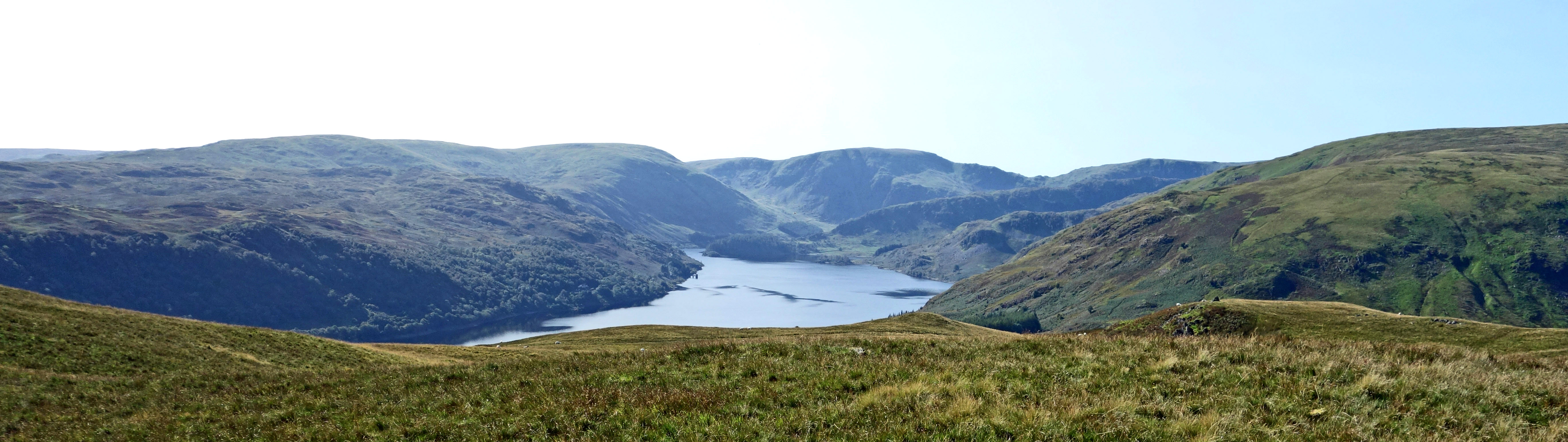
Haweswater from Bampton Common
The standard smart-arse question to ask about the Lake District is:
“How many Lakes are there in the Lake District?”
To which the hoped-for answer is: “15 or 16 or so.”
Which can then be followed by: “No, there’s only one. Bassenthwaite. It’s the only one with Lake in its name. All the others are Meres or Waters”.
It's so standard that most people interested in the Lake District will not fall for it.
So, here’s an alternative:
“How many Hills are there in the Lake District?” (It is important to say this with a capital H.)
To which the answer might be: “214” (assuming that the answerer is a devotee of Wainwright).
And then one can pounce: “No, there’s only two. Wether Hill and Loadpot Hill. All the others don’t have Hill in their name”.
If you do ask this question then be prepared for an argument. Wainwright (1955-66) included Eel Crag in his 214
but the Ordnance Survey and everyone else calls it Crag Hill. Crag Hill (839 metres) is considerably higher than
Loadpot Hill (672 metres) and Wether Hill (671 metres). Birkett (1994) also
included Sand Hill (756 metres), Jenkin Hill (735 metres)
and seventeen lesser Hills in his 541 tops. So, it could be argued that there are 22 Hills in the Lake
District, and that the highest Hill in England is Crag Hill. However, we strictly followed our dear friend
Wainwright so that our walk took us to not only the Lake District’s highest Hills but also its only Hills. (Perhaps I
should have added “according to Wainwright” to my title.)
Despite the two Hills’ eminence, Wainwright didn’t think much of them. Of Wether Hill, he said “The
top … is quite without interest, while the eastern slopes [the ones we walked up] are little better … There
are many fells more worthy of climbing than Wether Hill, the final slope being very dull.” The summit was
considered “a dreary and uninteresting place.” Loadpot Hill fared little better: “By Lakeland
standards … territory of this type is uninteresting … There is the appearance of desolation.”
Wainwright’s opinion was coloured by the fact that, although he described approaches up the flanks,
he knew that almost all walkers will reach Wether Hill and Loadpot Hill by walking along the High Street
ridge, from the north from Pooley Bridge or from the south from the High Street top itself. For such
walkers, Wether Hill and Loadpot Hill are barely noticeable rises along the long ridge. Walkers
will have had the view to the west – in particular, of the Helvellyn range – all the way and it doesn’t
suddenly change upon reaching Wether Hill or Loadpot Hill. It is different, however, for walkers from
the east, like us. After striding over moorland for some time, as we pass High Kop there is a
revelation through a dip in the High Street ridge of the Helvellyn mountains ahead, to which one can
only respond ‘wow’. As if by design, there is even a sight of Scafell Pike through the Grisedale col.
How can this be considered “very dull”?!
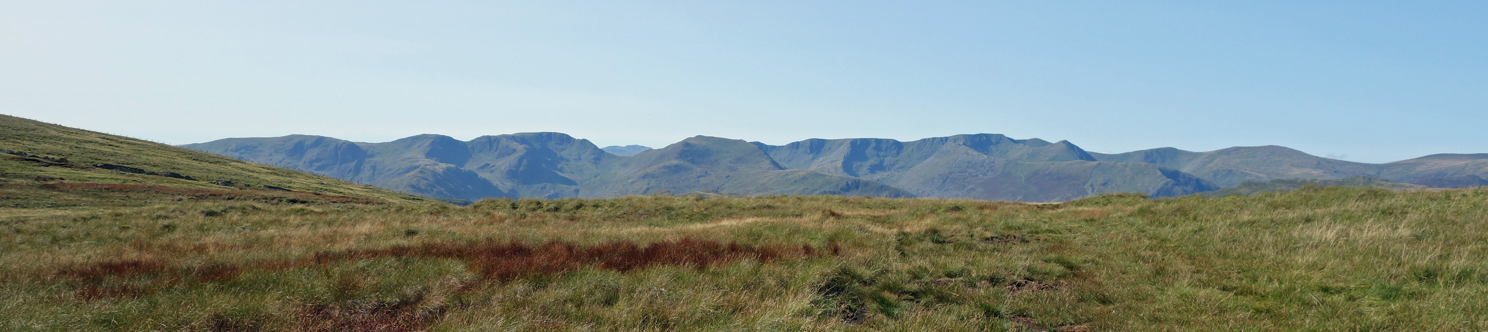
The Helvellyn range as seen approaching the High Street ridge from High Kop
We continued across the High Street ridge to sit on the western slopes in order to absorb the view. The
full extent of the Helvellyn ridge, from Dollywaggon Pike to Clough Head, was immediately ahead of us,
with all the eastern ridges picked out by shadow. Equally finely arrayed were the Fairfield hills to the
south, with the Coniston hills in the distance. To the north were Skiddaw and Blencathra, although we
couldn’t make out the Scottish hills that are, no doubt, visible on a clearer day. Directly below us
were the green fields of Martindale, with the intricate layout of the hills around Hallin Fell and Place
Fell displayed for us. To the northwest, on either side of Hallin Fell, two sections of Ullswater could
be seen.
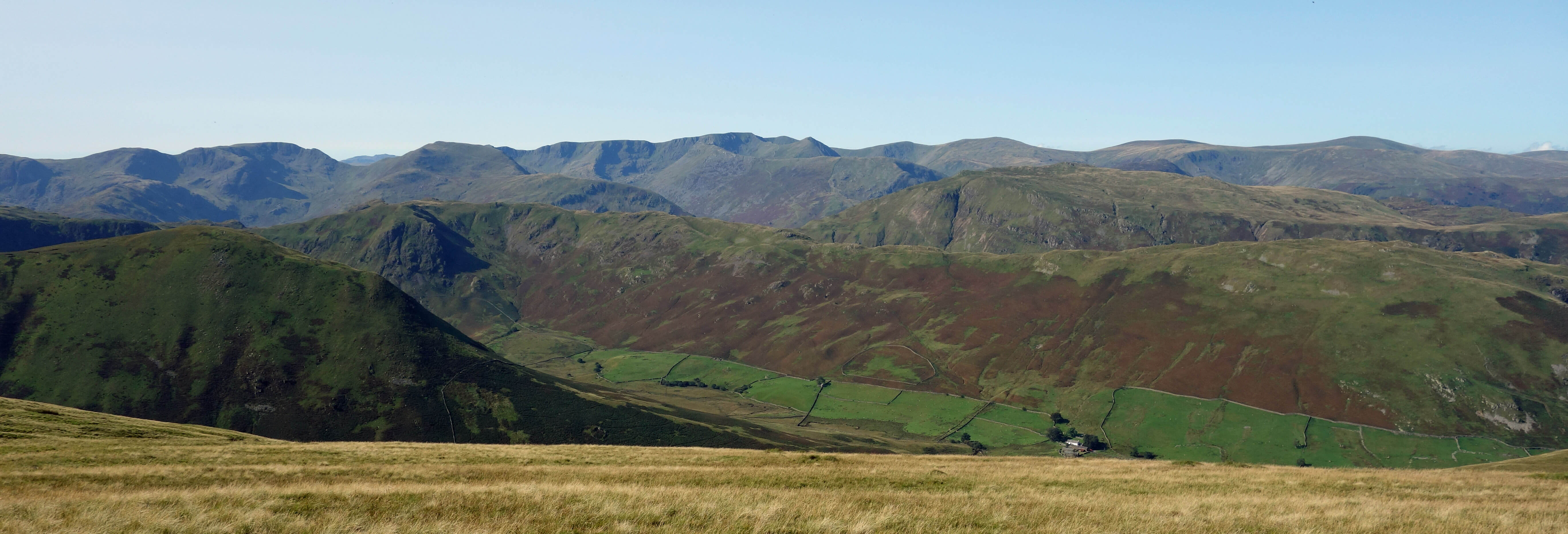
The Fairfield fells and Helvellyn range, with Martindale's Bannerdale below, from
the western slopes of Wether Hill
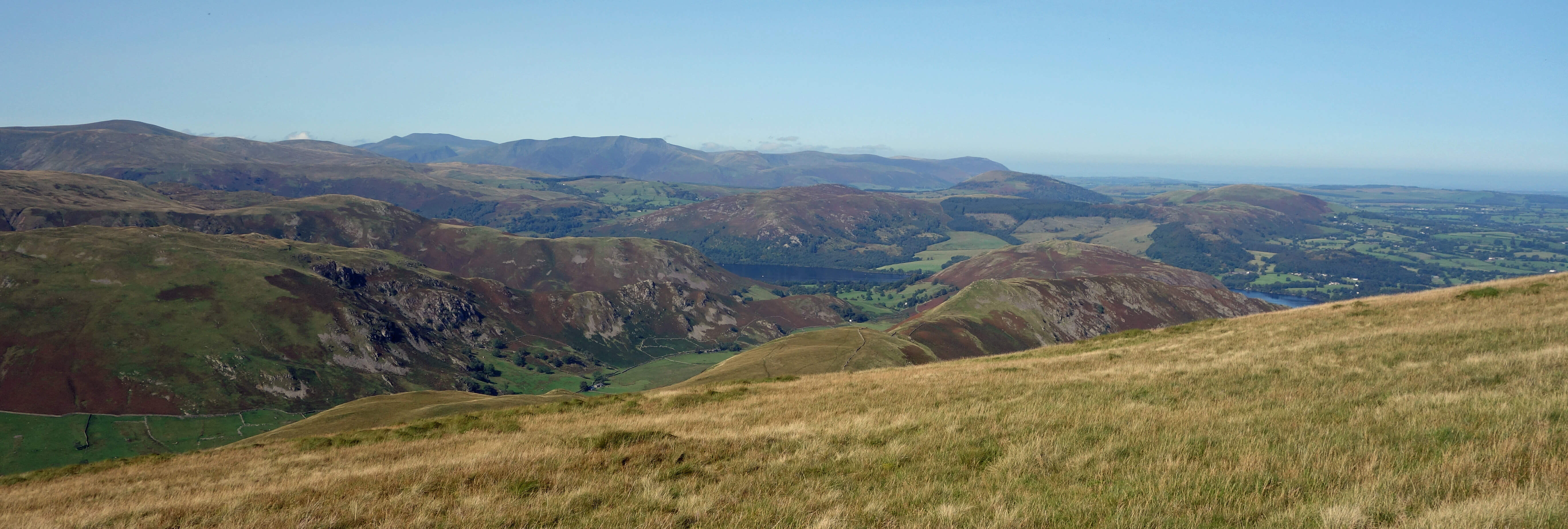
To Skiddaw and Blencathra over Ullswater from the western slopes of Wether Hill
Magnificent though the Helvellyn view was, it was only part of what was, for us, in these
covid-stained circumstances, a
perfect day. We will particularly remember – although it will mean little to any reader – the four
splendid spots where we paused for sustenance:
First, on a rare pair of rocks on the long, grassy
eastern slope of Wether Hill that provided a comfortable seat from which to survey over Haweswater and
the green Lowther valley towards Shap;
Secondly, the afore-mentioned lunch break on the western slope of
Wether Hill, looking towards Helvellyn;
Thirdly, a small bank beside the path down from Loadpot Hill, where
we ate an apple while looking across the Eden valley to the Cross Fell set of hills and the Howgills;
And fourthly, after
a stroll about the village, by
the bridge at Bampton Grange where we cooked ourselves our evening meal (chilli, sweetcorn, kale, tomatoes,
plus strawberries and Heinichen’s 0.0) which we consumed sat upon a low wall by the river.
A local man, out
for an evening jog, paused for a chat, from which we learned that if we had been sitting here in January
then we would have been underwater. The sun lowered over the High Street Hills, and we left.
Date: September 17th 2020
Start: NY521179, by the bridge in Bampton Grange (Map: OL5)
Route: SW – Hungerhill, Drybarrows – SW, W – Low Kop, High Kop, High Street path – N –
Wether Hill, Loadpot Hill – E, NE past The Pen – Howe – E, SE – Gillhead, Woodfoot, Bampton, Bampton Grange
Distance: 11 miles; Ascent: 550 metres
Home
Preamble
Index
Areas
Dales
Hills
Lakes
Places
Reserves
Rivers
Structures
Villages
References
Me
© John Self, 2018-

Top photo: The western Howgills from Dillicar;
Bottom photo: Blencathra from Great Mell Fell