
Home
Preamble
Index
Areas
Dales
Hills
Lakes
Places
Reserves
Rivers
Structures
Villages
References
Me
Saunterings: Walking in North-West England
Saunterings is a set of reflections based upon walks around the counties of Cumbria, Lancashire and
North Yorkshire in North-West England
(as defined in the Preamble).
Here is a list of all Saunterings so far.
If you'd like to give a comment, correction or update (all are very welcome) or to
be notified by email when a new item is posted - please send an email to johnselfdrakkar@gmail.com.
103. Bogged Down around Rawcliffe Moss
In 1745 the weather caused an event five miles west of Garstang the like of which will almost certainly never be
seen in Lancashire again. The event itself was not the most spellbinding but the fact that it happened in 1745
and that similar won’t happen again tells us something about the history of the region. On this walk I encircled
the site of the 1745 event.
 I began from the eponymous church of Churchtown, that is,
St Helen’s,
which I understand is called ‘the Cathedral of the Fylde’.
This tells me two things. First, that there is no actual Cathedral of the Fylde, and quite right too because the Fylde is
flat and it would be unseemly for a spire to puncture the vast skyscapes, although there is in fact a tiny spire on St Helen’s,
hosting a weather-vane. Secondly, that this church, fine as it may be, is not a cathedral, which is good to know because
I couldn’t define what a cathedral is. Does a cathedral have to have a spire? Does a
spire have to be spiral?
I began from the eponymous church of Churchtown, that is,
St Helen’s,
which I understand is called ‘the Cathedral of the Fylde’.
This tells me two things. First, that there is no actual Cathedral of the Fylde, and quite right too because the Fylde is
flat and it would be unseemly for a spire to puncture the vast skyscapes, although there is in fact a tiny spire on St Helen’s,
hosting a weather-vane. Secondly, that this church, fine as it may be, is not a cathedral, which is good to know because
I couldn’t define what a cathedral is. Does a cathedral have to have a spire? Does a
spire have to be spiral?
I followed the Wyre Way westwards, through the sickly sweet smell of rampant Himalayan balsam, ameliorated somewhat
by the sewage works. After a mile the Way left the River Wyre for the A586, which wasn’t much fun, and passed a sign saying
St Michael’s-on-Wyre, which caused me some angst. When I started these Saunterings I resolved, when in doubt, to
use the Ordnance Survey spelling of place-names. However, not many people spell Haystacks as Hay Stacks or
Scafell as Sca Fell as the OS does, and when it comes to compound names like St Michael’s-on-Wyre the OS is not consistent in
its use of hyphens. In this case, the OS opts for St Michael's on Wyre. But surely the people who put up road signs should know.
Within the village it is invariably St Michaels, with no apostrophe.
So distracted was I that I walked through St Michael’s-on-Wyre without noticing anything of it, although I did pause at
the end of it, at the church,
St Michael’s
(of course), which is, like St Helen’s, a Grade 1 listed building. I continued
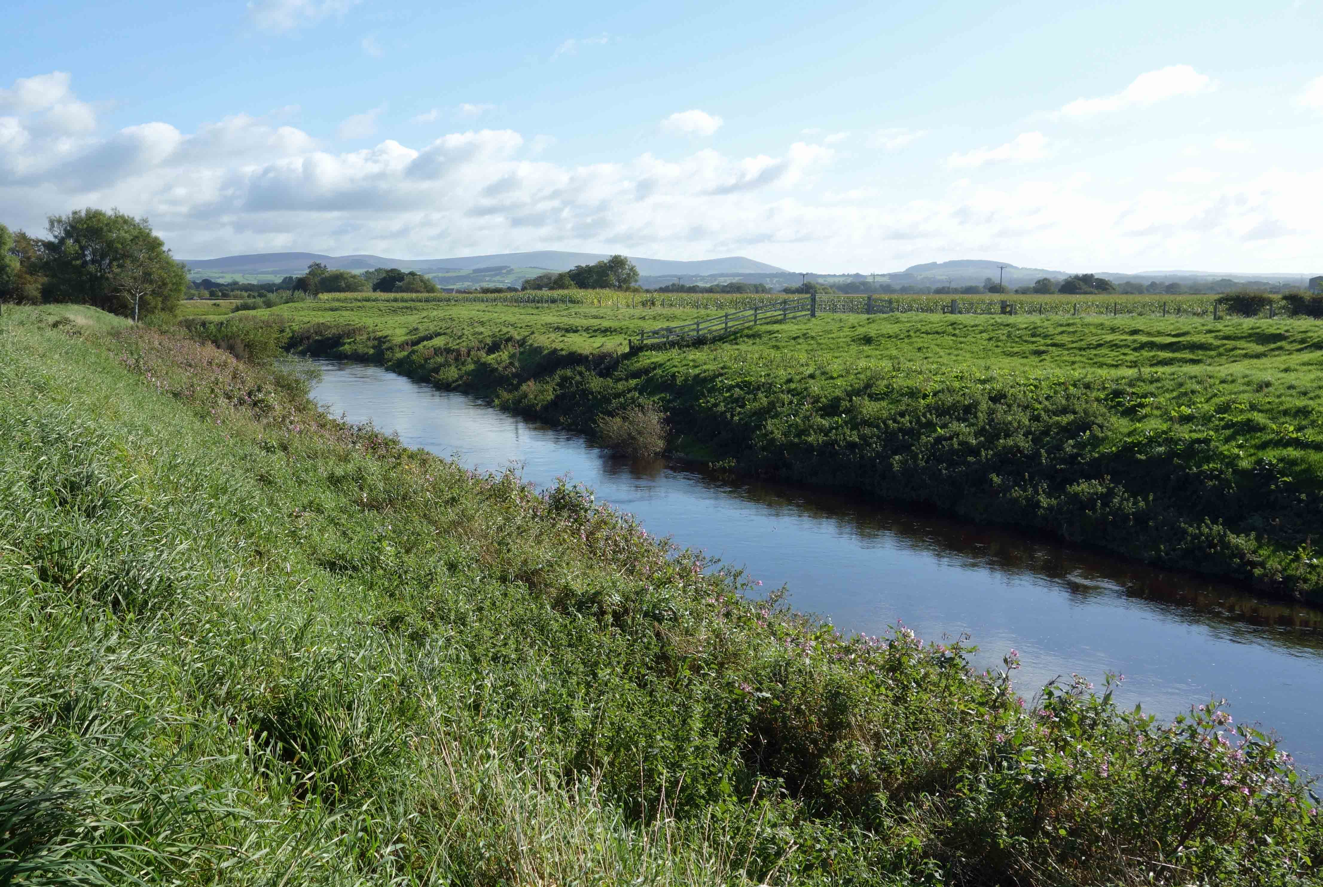
by the Wyre, which according to the OS map is at its tidal limit at this point. Since the Wyre still has fifteen
miles to go to reach the estuary at Fleetwood it obviously has a sedate journey from here. The Wyre is now snug
between high banks to prevent flooding, which meant that when I left the Wyre to walk along the quiet Rawcliffe Road I
could no longer see it.
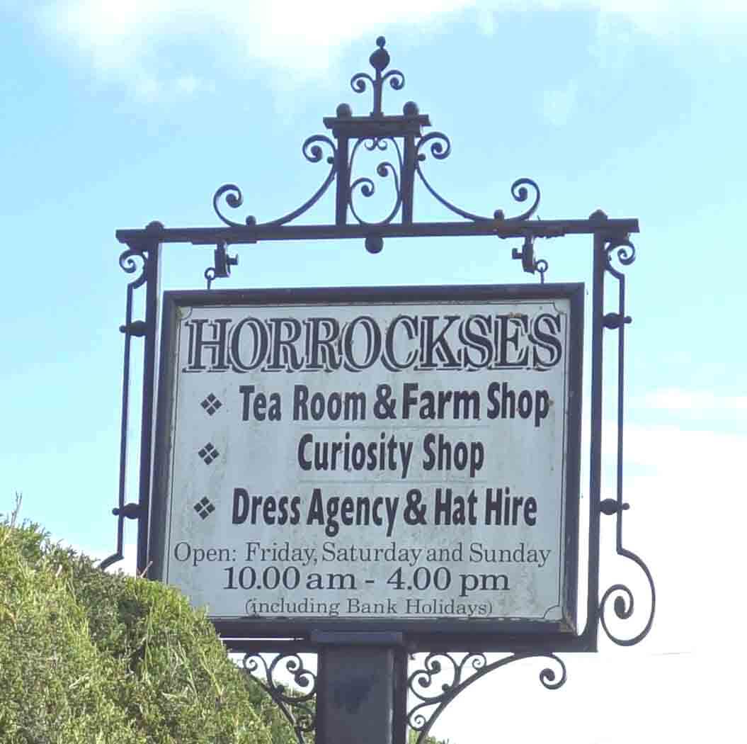
I then passed Horrockses, whose sign said that
it was a “Curiosity Shop, Dress Agency and Hat Hire”, which perhaps is just what the few locals need.
Beyond Ratten Row I walked north away from the Wyre, climbing all of about five metres, to survey the scene. But
there was nothing to see, in all directions. It was flat for miles, like the Australian outback. No, flatter – and
greener – and wetter – and without the kangaroos. I will need to take a Creative Writing course to describe the scene
adequately. In the meantime, I can only say that there were many fields, most green and a few yellow, some with sheep
or cows or horses. I had seen maize by the Wyre but from here on I saw no crops. The first of the farms passed was
the wryly named Belle Vue. At least, that’s what the OS map says. As elsewhere in this region, the names given on the
map often don’t seem to be owned by any particular building.
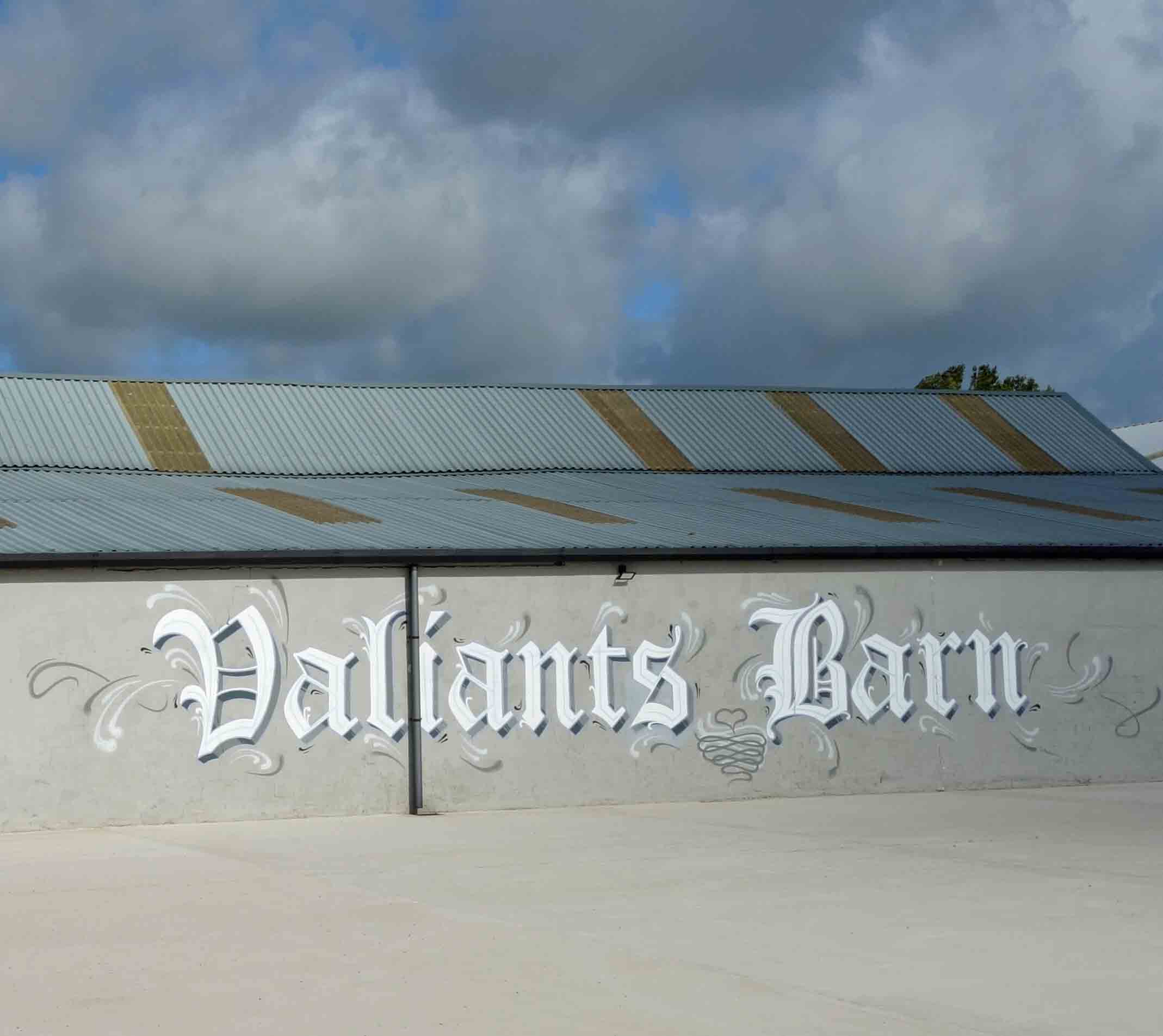
However, Valiant’s Barn displayed its name in large ornate
letters (I couldn’t work out why).
 Passing Wilson House Holiday Park, I turned east on Skitham Lane, which I followed for three miles. It was the
most tedious three miles I have walked since I started these Saunterings. While I think of something interesting to
say about it, here’s a question: Where would you say is the heart of Lancashire? The county
of Lancashire is, of course,
much smaller than when it included Manchester, Liverpool and
what is now south Cumbria, but it is still large enough to have a heart. Where?
Passing Wilson House Holiday Park, I turned east on Skitham Lane, which I followed for three miles. It was the
most tedious three miles I have walked since I started these Saunterings. While I think of something interesting to
say about it, here’s a question: Where would you say is the heart of Lancashire? The county
of Lancashire is, of course,
much smaller than when it included Manchester, Liverpool and
what is now south Cumbria, but it is still large enough to have a heart. Where?
I passed a place that sold – what? Have a guess (I’ll tell you at the end of the paragraph). And on through
Skitham, a name that probably derives from the old English ‘scitan’, from the proto-Germanic ‘skit’. The ‘k’ has
softened in modern English. Ah, now, I am sure that you are agog to know
what happened in 1745. An analogy may help. Imagine that you made a sponge cake but it was too soggy. You trimmed off
the collapsed edges so that the cake had a neat little wall. Then you accidentally left the cake in the rain.
The sponge continued to absorb the rainwater – until it could absorb no more, at which point the cake ‘burst’ and
flattened itself over a wide area. (Sliding-door wardrobes – did you guess it?)
A ‘bog burst’ occurred on Rawcliffe Moss in 1745. The bog was a raised mire, which is naturally higher in the centre but in this case was unnaturally considerably higher because the surrounding peat had been removed for burning and the land had been drained, causing further shrinkage to lower the land. A similar situation can still be seen today at Winmarleigh Moss to the north, a small bog but the largest remaining in Lancashire, where the bog stands rather weirdly perched a metre or two above surrounding farmland, which is not what you expect of a bog. After heavy rain saturated the Rawcliffe Moss bog it collapsed to spread its contents over a wide area. A witness said that the centre of the bog sank to leave the bed of a river a mile long and half-a-mile wide.
The reason that a similar bog burst will not occur in Lancashire again is that there is little similar bog left. People in Fylde continued to extract peat for burning until the 1950s and the land has been comprehensively drained. The old bogs of the Fylde are now criss-crossed by many ditches, creating rich pasture. The outcome of the peat extraction and the drainage is that the land is now lower than it was and therefore at higher risk of sea-flooding, which is, of course, why the Pilling Embankment was built in 1981.
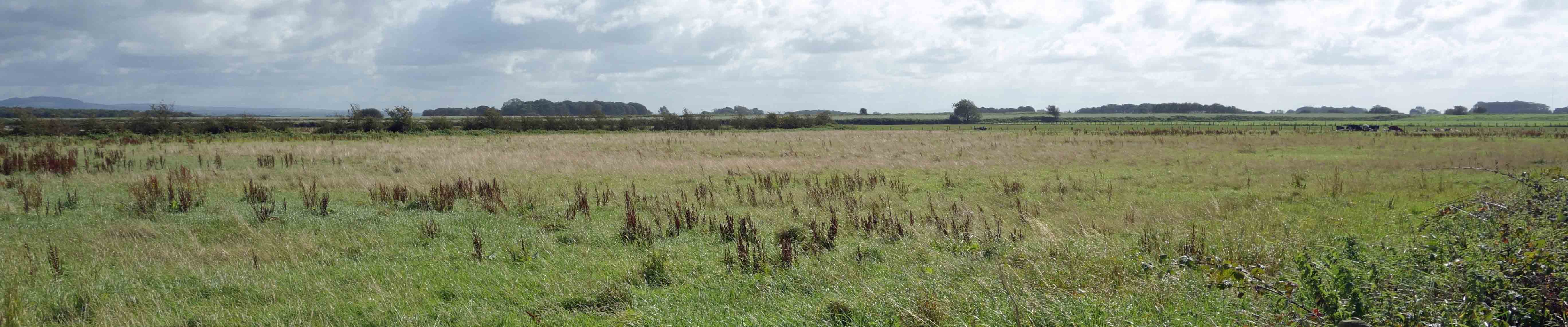
Rawcliffe Moss (I feel obliged to include a photo of Rawcliffe Moss in order to
show that there is indeed nothing to see)
I had achieved my main ambition of the day – to see the site of a bog burst, although no evidence of it remains today – but
now what? I didn’t think I could cope with any more excitement so I walked on
to the village of Nateby. Actually, there
was no alternative. The road went on, above the level of the fields, so that I could be sure that
I wasn't missing anything. I passed Trashy Hill, as anybody would. Hereabouts,
any eminence that it is a couple of metres higher than the fields is called Something Hill. How droll.
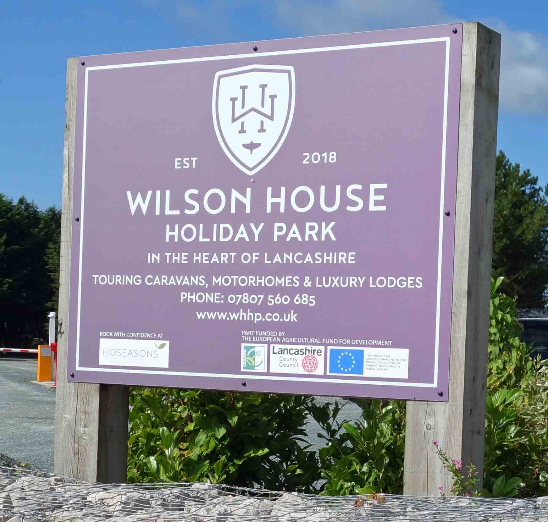
 So, where is the heart of Lancashire? The Wilson House Holiday Park is in it, according to its sign.
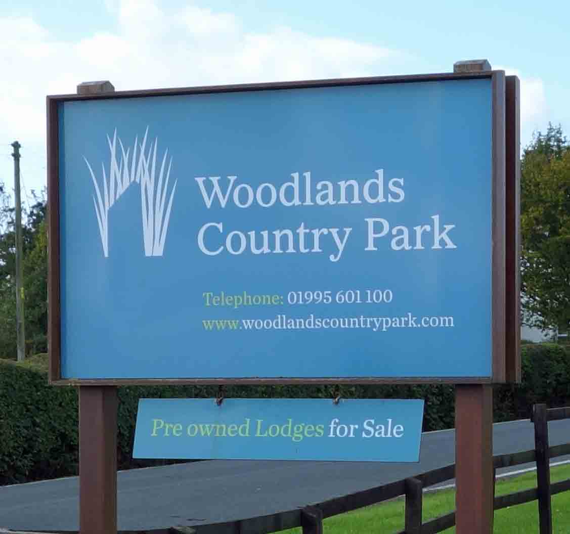
Myself, I’d say that this Park is in the middle of nowhere. The sign says that it was completed in 2018 after EU funding. Oh for the days when we could pay our taxes, have our government send money to Brussels, for a committee there to decide that a Holiday Park here is just what this region needs. I next passed Woodlands Country Park, with an ornamental entrance. Somebody has spent a lot of money here (the sign didn’t mention the EU this time). There must be a bigger market for people who really do want to get away from it all than I thought.
So, where is the heart of Lancashire? The Wilson House Holiday Park is in it, according to its sign.
Myself, I’d say that this Park is in the middle of nowhere. The sign says that it was completed in 2018 after EU funding. Oh for the days when we could pay our taxes, have our government send money to Brussels, for a committee there to decide that a Holiday Park here is just what this region needs. I next passed Woodlands Country Park, with an ornamental entrance. Somebody has spent a lot of money here (the sign didn’t mention the EU this time). There must be a bigger market for people who really do want to get away from it all than I thought.
I approached Nateby with some trepidation because the only previous time that I had visited (in 2007) I was suspected
of loitering with intent. At that time, the Nateby region was in a spasm of excitement because someone had thought he’d
found the remains of a Roman road (a side-road from the Lancaster-Ribchester road to the Wyre estuary) and someone else
had thought he’d found, from aerial photographs, a huge circular henge. I hurried then to visit before hordes of tourists
engulfed this would-be Stonehenge of the North. I parked near the school, had a snack and prepared to set off while the
kids ran about the playground. They were ushered indoors and two teachers came out to ask what I was up to. I mentioned
the Roman road and the henge, which reassured them that I was a weirdo but one harmless to their children. There has,
I think, been no more news about the
henge
(which there surely would have been if it were significant) and the news
about the
Roman road
is that it is unlikely to be one.
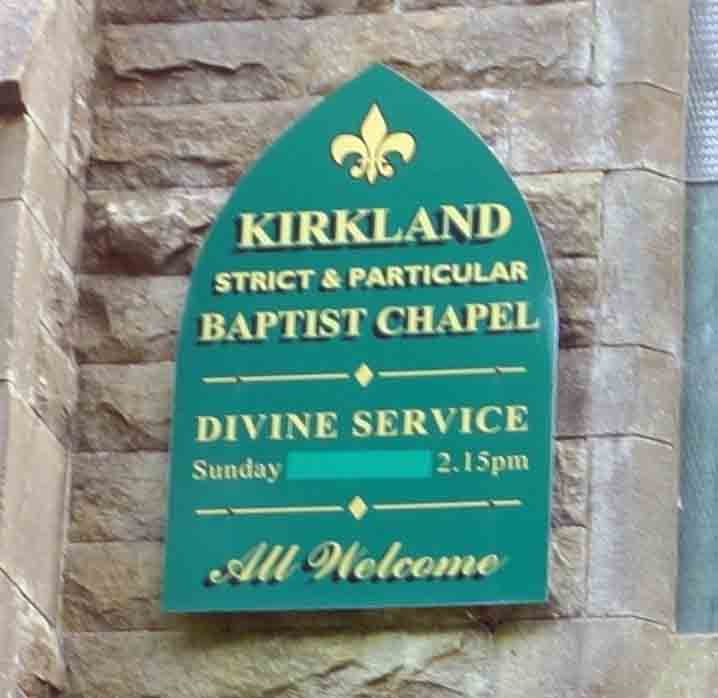 This time I stayed clear of the school but I wanted to see the church again, or rather the sign on the church. I realise that
this is a touchy topic but I have to say that Christians sure make it hard for someone like me. Love thy neighbour is all
very well as a principle but in practice it seems that Christians hardly love one another. Any slight disagreement over
some sub-clause of the Christian faith leads to another group flouncing off and setting up yet another –ism, with its own
churches and so on. Lutheran, Anabaptist, Waldensian, Catholic, Presbyterian, Congregational, Calvinist, Apostolic,
Mennonite, Pentecostal, Adventist, Coptic, Protestant, Orthodox, Quaker, Christadelphian, Methodist, Hutterite, Moravian, Evangelical,
Anglican, Unitarian, Baptist, Episcopal, Wesleyan, and on and on. I have no interest whatsoever in the precise differences between them.
This time I stayed clear of the school but I wanted to see the church again, or rather the sign on the church. I realise that
this is a touchy topic but I have to say that Christians sure make it hard for someone like me. Love thy neighbour is all
very well as a principle but in practice it seems that Christians hardly love one another. Any slight disagreement over
some sub-clause of the Christian faith leads to another group flouncing off and setting up yet another –ism, with its own
churches and so on. Lutheran, Anabaptist, Waldensian, Catholic, Presbyterian, Congregational, Calvinist, Apostolic,
Mennonite, Pentecostal, Adventist, Coptic, Protestant, Orthodox, Quaker, Christadelphian, Methodist, Hutterite, Moravian, Evangelical,
Anglican, Unitarian, Baptist, Episcopal, Wesleyan, and on and on. I have no interest whatsoever in the precise differences between them.
With Churchtown and St Michael’s-on-Wyre in the parish of Kirkland this is a region that takes its religion
seriously. The Nateby church sign says that it is a “Strict & Particular Baptist Chapel”, whatever that is. The sign
also says “all welcome” so they probably don't have
bouncers at the doors keeping out those who are not particularly strict. Sadly, the
sign no longer says “marriages solemnised” as it did in 2007. I do hope that our Strict & Particular Baptists are not
treating their marriages too frivolously nowadays.
Date: September 9th 2020
Start: SD482428, by St Helen’s Church, Churchtown (Map: 296)
Route: SW on Wyre Way – St Michael’s-on-Wyre – W on Wyre Way, on Rawcliffe Road – Ratten Row – SW, N – Hoskinshire, Crook Farm – E on Skitham Lane – Nateby – S through Poplar Grove Farm – Sharples Lane – E – Churchtown
Distance: 10 miles; Ascent: 10 metres
Home
Preamble
Index
Areas
Dales
Hills
Lakes
Places
Reserves
Rivers
Structures
Villages
References
Me
© John Self, 2018-

Top photo: The western Howgills from Dillicar;
Bottom photo: Blencathra from Great Mell Fell