
Home
Preamble
Index
Areas
Map
References
Me
Drakkar
Saunterings: Walking in North-West England
Saunterings is a set of reflections based upon walks around the counties of Cumbria, Lancashire and
North Yorkshire in North-West England
(as defined in the Preamble).
Here is a list of all Saunterings so far.
If you'd like to give a comment, correction or update (all are very welcome) or to
be notified by email when a new item is posted - please send an email to johnselfdrakkar@gmail.com.
156. The Long and Winding Hornby Road
I walked along the Hornby Road
to see how the gulls are getting on. Gulls? Who cares about gulls – large,
noisy, aggressive birds that pinch our seaside chips? I don’t particularly but the long and
winding saga of the gulls
on the Bowland hills is one of nefarious goings-on, hidden from the public eye, indicative of the
complex relationships between government, landowners and environmental policy.
From Barkin Bridge I walked to the end of the surfaced road at High
Salter. On the way I passed agitated oystercatchers, lapwings, skylarks, pied wagtails and
swallows, no doubt concerned about their young, while a few gulls whirled above in the breeze, but
not, I think, the species that nest high on the moor.
The Hornby Road (also known as the Old Salt Road) is one of the
best walking tracks in Lancashire – but one frequented
by few walkers. That’s because the track runs ten miles or so over the watershed
(leading eventually to Slaidburn, at the southern end, and to Hornby, at the northern end)
and to walk the track end-to-end means making arrangements for transport at one or both ends. It
isn’t easy to create a sensible circular walk by leaving the track for some rough fell-walking
either. On this occasion I hoped to complete a d-shaped walk, that is, a walk south on the
track, a loop off it to Wolfhole Crag, and a return north on the track.
The track provides wide vistas, ahead to the remote head of Roeburndale, to the right
to the slopes of Mallowdale Pike, leading up to Ward's Stone, the highest point of Bowland,
and to the left far across to the peaks of the Yorkshire Dales, on this occasion just
grey shapes. The track becomes increasingly isolated, far from any habitation or modern road,
and therefore utterly quiet, apart from the sound of birds, among which that of the curlew
began to dominate. What an evocative sound it is!
Further along, though, around High Salter Close, the gulls began to take over.
The gulls started breeding in numbers on the Bowland hills in the 1930s, after
their coastal sites had been converted to golf courses, holiday homes,
caravan parks, and so on. With plentiful food and an absence of predators (because they are
eliminated by gamekeepers to protect the grouse), the gulls flourished on the moor. By the
end of the 1970s over 25,000 pairs were nesting, forming the largest colony of lesser
black-backed gulls in the world at that time. In 1978 a licence was granted (by the
equivalent of today’s Natural England) to kill most of the gulls. Why?
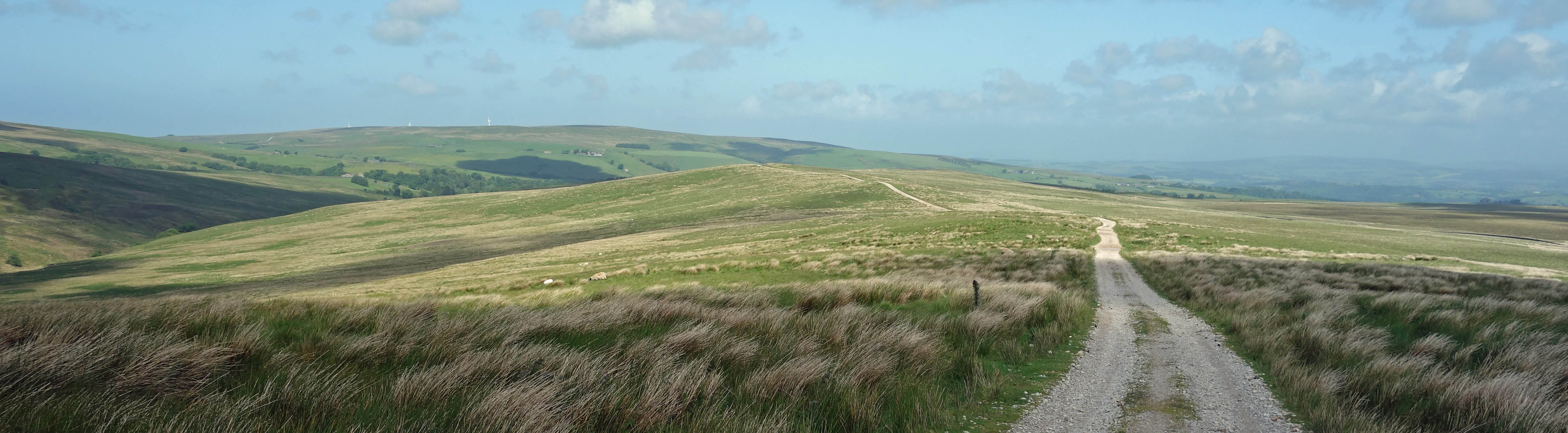
The Hornby Road (looking north)
The official reason for killing the gulls was that they were, through their
excrement, considered to be polluting the water, which was collected for the inhabitants
of Preston and elsewhere to drink.
Over three years 50,000 gulls were killed and tens of thousands of clutches were destroyed.
That reduced the number of nesting gulls to tolerable levels, as far as pollution was
concerned – but the licence continued to be renewed, year-by-year. Why?
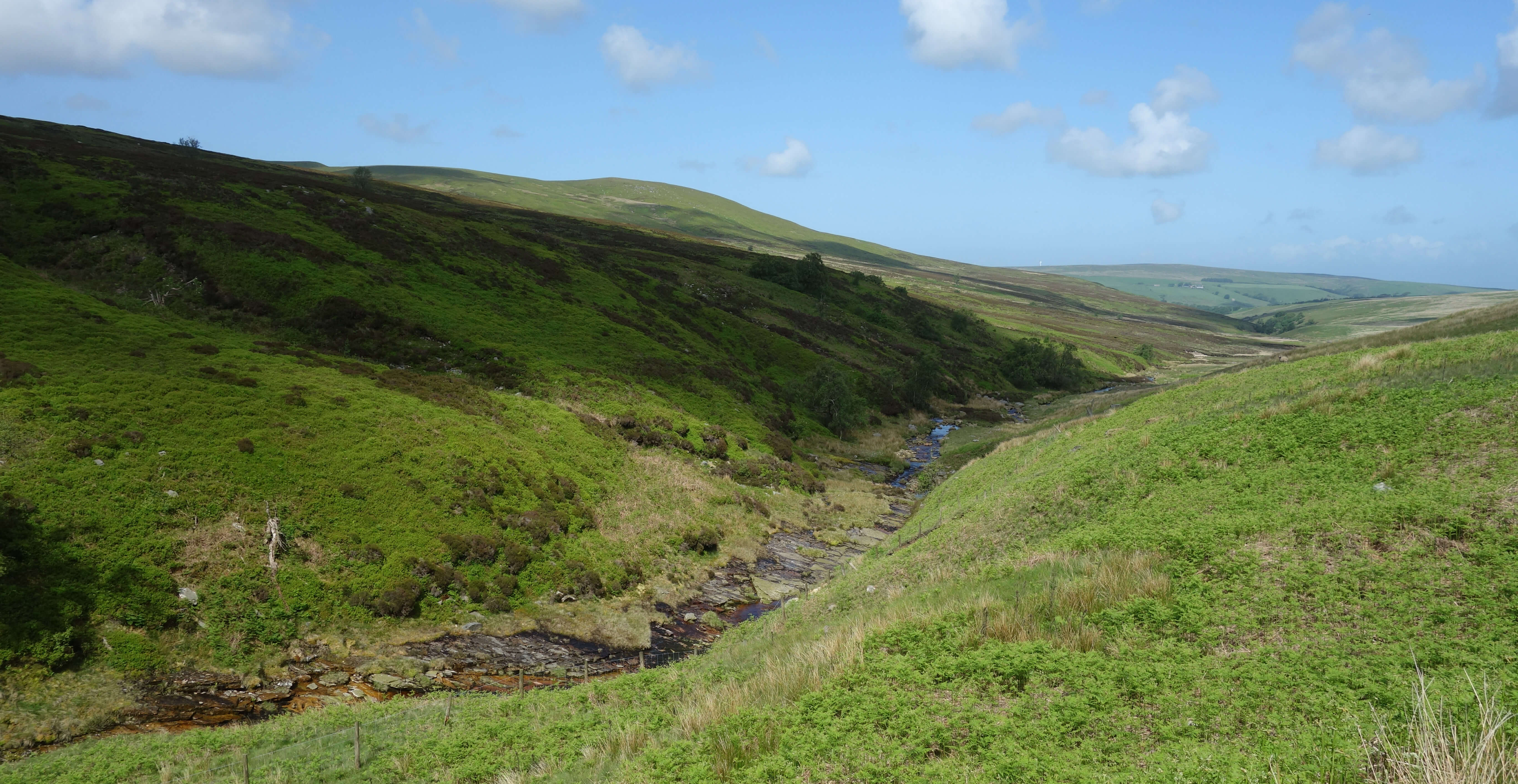
I walked on to Alderstone Bank, where large gritstone boulders lie about, and then
dropped down, for a bit of walking on grass, to the ford on the shooters' track over the infant River Roeburn.
As I walked on up the track, I heard my first grouse. In fact, I only saw four grouse (two of them
chicks) on the whole walk. I began to wonder if the estate was giving up on grouse-shooting.
The income must be negligible compared to the billions already owned – hardly worth the
increasing opprobrium that the activity attracts. But then I saw that the old shooting cabin
has been replaced by a new one.
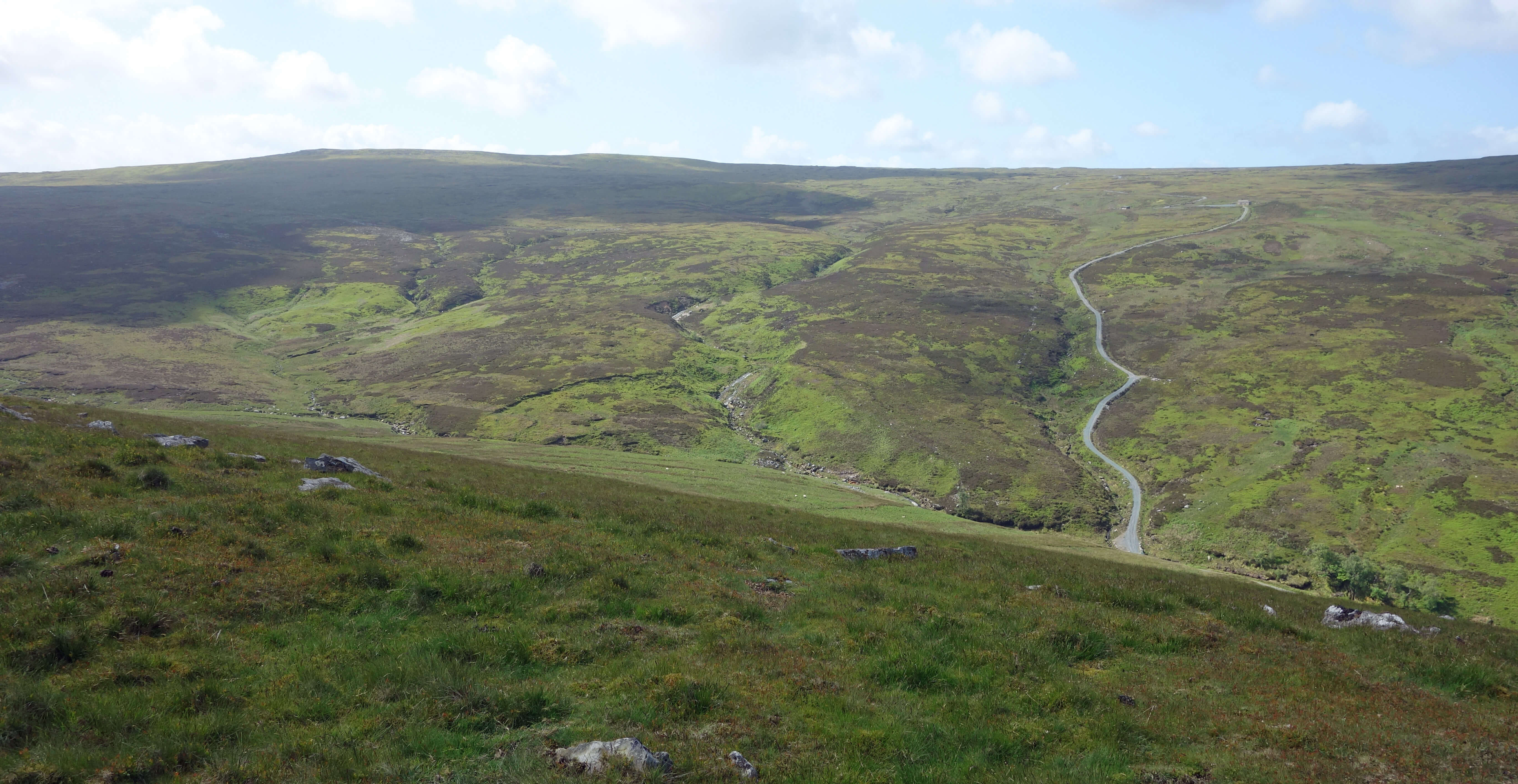
Left: The shooters' track seen from the Hornby Road, with Wolfhole Crag to the left; Right:
The infant River Roeburn.
The licence to kill the gulls may have been renewed simply to ensure that they didn't begin to
increase again. I am sure, however, that the gamekeepers were not unhappy to continue killing
gulls because they were occupying moorland that would otherwise host grouse – and, moreover, the gulls
were partial to grouse eggs and young. All this was before the Open Access legislation
of 2000. Walkers were not then allowed on these moors and few people knew about this killing.
In 2001 the Bowland Fells became a Special Protection Area, which meant that under EU law,
and hence UK law, the gulls became legally protected. Nevertheless, the licence to kill gulls
continued to be renewed. Why?
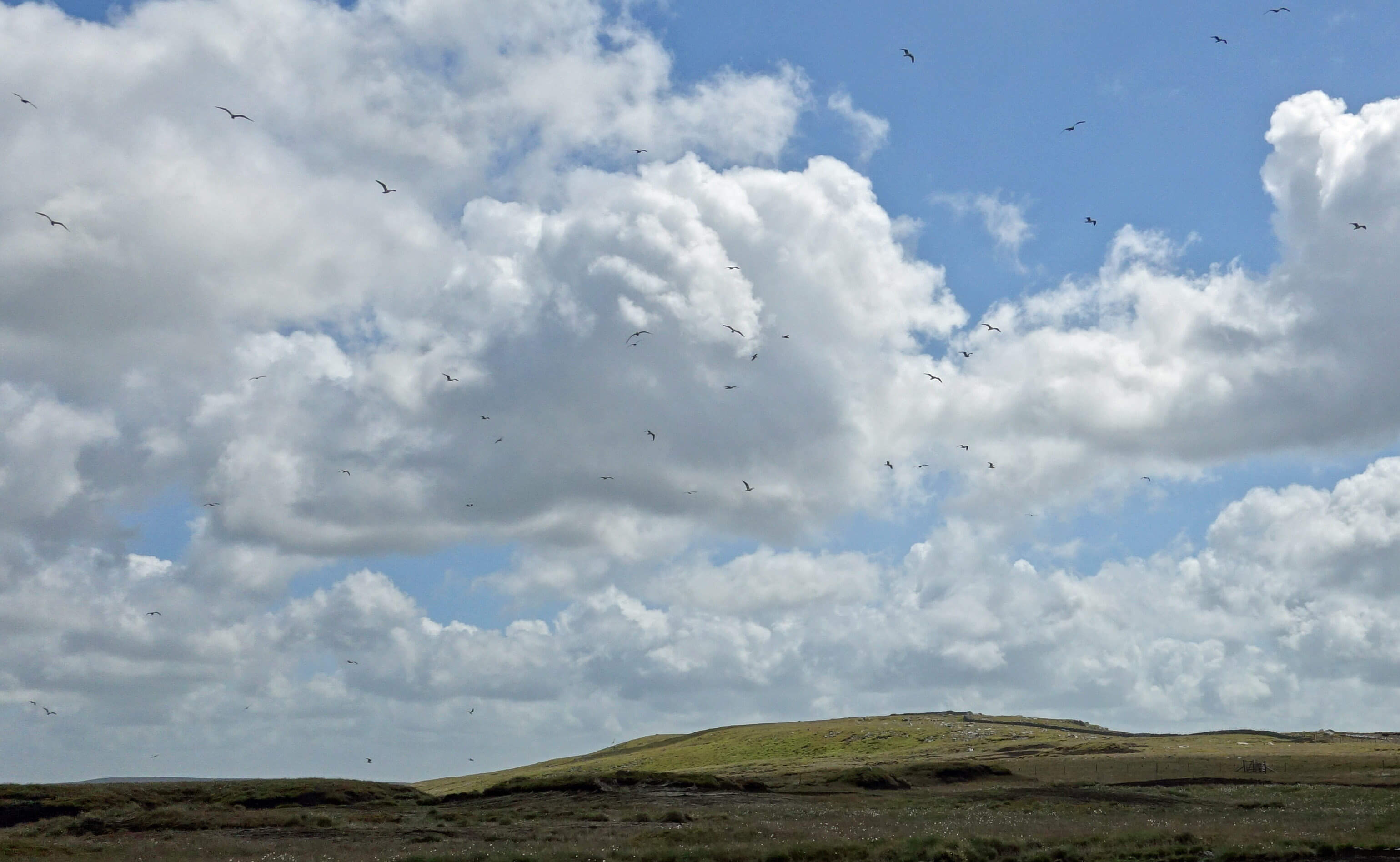
Further on up the shooters' track, as I approached the watershed at Brown Syke, there was nothing but
gulls in the sky. It became a little unnerving.
Don't be misled by the 'lesser' in the name of lesser black-backed gulls. They are
larger than buzzards. They are, thankfully, not as aggressive as buzzards when they
fear their young are being disturbed. They don't dive-bomb a walker but they swirl
about in great numbers, squawking their disapproval, swooping over the moor occasionally
but not towards the walker. After a while, one becomes accustomed to their presence
– as a cow does the flies around its head.
 Left: Wolfhole Crag, with a few of the gulls.
The most gulls that I had about me at any time was perhaps a couple of hundred.
My impression is that there are fewer gulls than there were. They used
to congregate on Brennand Fell, south of Wolfhole Crag, but I think that they have dispersed
more widely about the moor, sensibly avoiding becoming a shooting gullery.
Not that they were always shot: some were gassed, or poisoned, or netted, or (no doubt) just
trampled on.
At the watershed I turned east towards Wolfhole Crag but halfway along I changed
my mind. I never feel beholden to any objectives I had at the start of a walk.
Wolfhole Crag (527 metres) was only a few metres higher than where I had reached and I could
see that I wouldn't be rewarded with a better view at the top. The grey shape of Pendle, for
example, could hardly be seen. It was windy too, and the wind had more puff than me.
There's no pleasure walking amongst these gulls
and I could see no point in disturbing more of them – so I turned to walk
back the way I came.
There seems to be only two possible reasons for licensing the illegal killing of the gulls. Either
Natural England did not realise that the killing was illegal, which seems scarcely credible for a
body specifically responsible for environmental law. Or Natural England turned a blind eye to the
illegal killing. Perhaps they felt that nobody would know or care about activities on these moors
or would make a fuss about gulls.
Perhaps they didn’t want a disagreement with wealthy landowners who preferred grouse to gulls.
Eventually, in 2011 or so, the licence was not renewed. Why?
As I dropped down the shooters' track I saw on the distant horizon two cyclists on
the Hornby Road. They were the only people I saw all walk.
Eventually regaining the Hornby Road, I walked north, pausing at Alderstone Bank, where,
according to my notes of a previous occasion, there is a grand wide-ranging vista from Black Combe around to
Pen-y-ghent. On this occasion I could not see the former at all and the latter was still
just a grey outline. Not that I am complaining: the nearer views of Roeburndale and
Goodber Fell were perfectly pleasant.
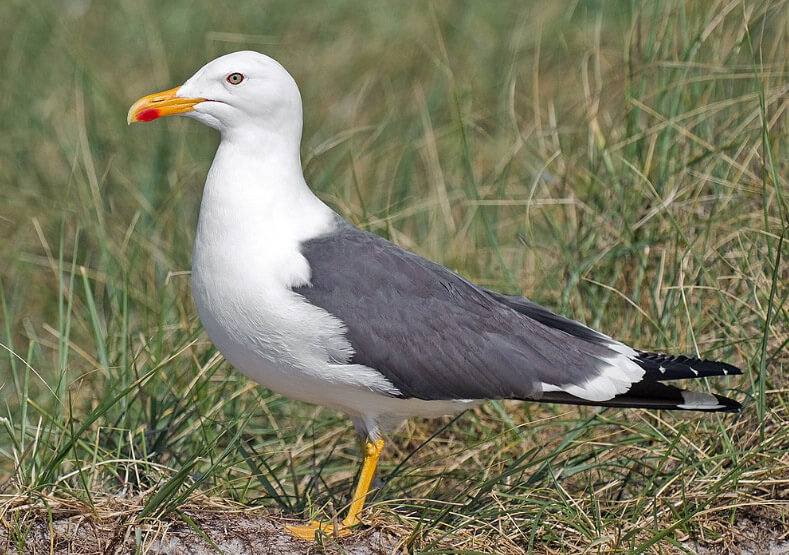 Right: Lesser black-backed gull.
The licence to kill gulls was not renewed after there was some public concern, with
critical articles
in the national press, that
Natural England was enabling this illegal killing. In 2012, after the decades of killing, there
were said to be about a thousand gull nests on the Bowland fells. Natural England said in 2012
that despite the absence of a licence “widespread killing” continued. In 2017 they wrote that
the “killing of juvenile lesser black-backed gulls was undertaken at Brennand Fell, part of the
Bowland Fells SSSI, without Natural England’s consent”. A
'reprimand' was
written but nobody
has been charged with an offence. Why?
I strode back on the Hornby Road with the highlight being a spectacular display
from a curlew. It must have had young nearby because it swooped about me with blood-curdling calls.
I really enjoyed it. No longer was it entertaining me with its liquid trills as it planes earthward.
It repeatedly swept close to me, harshly caterwauling.
It was great to see the bird in action at such close quarters, although I suppose I should
regret disturbing its family.
Nobody has been charged after the clearly criminal actions because
Natural England prefers to reach agreement about environmental practices through negotiation and
doesn’t really have the resources for court cases, especially against wealthy landowners. I don’t
know what has happened in recent years. I expect that there is a stand-off, while the legal
position is clarified. Since we are no longer part of the EU I assume that the EU designation of
Special Protection Area has lapsed. Although the government did say (for what it’s worth) that
we will inherit EU laws, I’d guess that this particular law is one that this government and its
friends would like to end. So the future of Bowland gulls seems bleak.
Bowland is well-known for its grouse-shooting, with the record bag of 2,929 grouse on a day's shoot
being set here in 1915. It is less well-known that more gulls than grouse have been killed in Bowland
in the last fifty years. It doesn't end there. The region I walked in is also notorious for
the disappearance – oh, let's be clear, the killing – of two rare protected hen harriers in 2015. Their tracking devices
suddenly stopped working.
It is very rare for such a device to fail, so two failing within a short distance of each
other is implausibly unlikely. No trace of the hen harriers and their trackers was found.
It is a macabre irony that all this killing is to enable the survival of a particular bird – to be killed for fun.
I have mixed feelings about the gulls in Bowland.
Although the gulls have been here for nearly a century it still seems incongruous to walk these
moors to the accompaniment of screeching gulls. If you close your eyes and just listen then you'd
imagine yourself at a harbour, say, with gulls scrapping over the waste from a fishing boat.
Of course, I would prefer to hear what we regard as moorland birds – curlew, lapwing, golden plover,
skylark, grouse (although no doubt someone will tell me that some of those aren't really moorland birds either).
The gulls' colonisation of the fells is, I suppose, a natural one – although
one forced by our ruining their ancient nesting sites by the coast. On balance, I’m not sure that I really
want gulls on the moors. I am, however, certain that I don’t
want gamekeepers killing them.
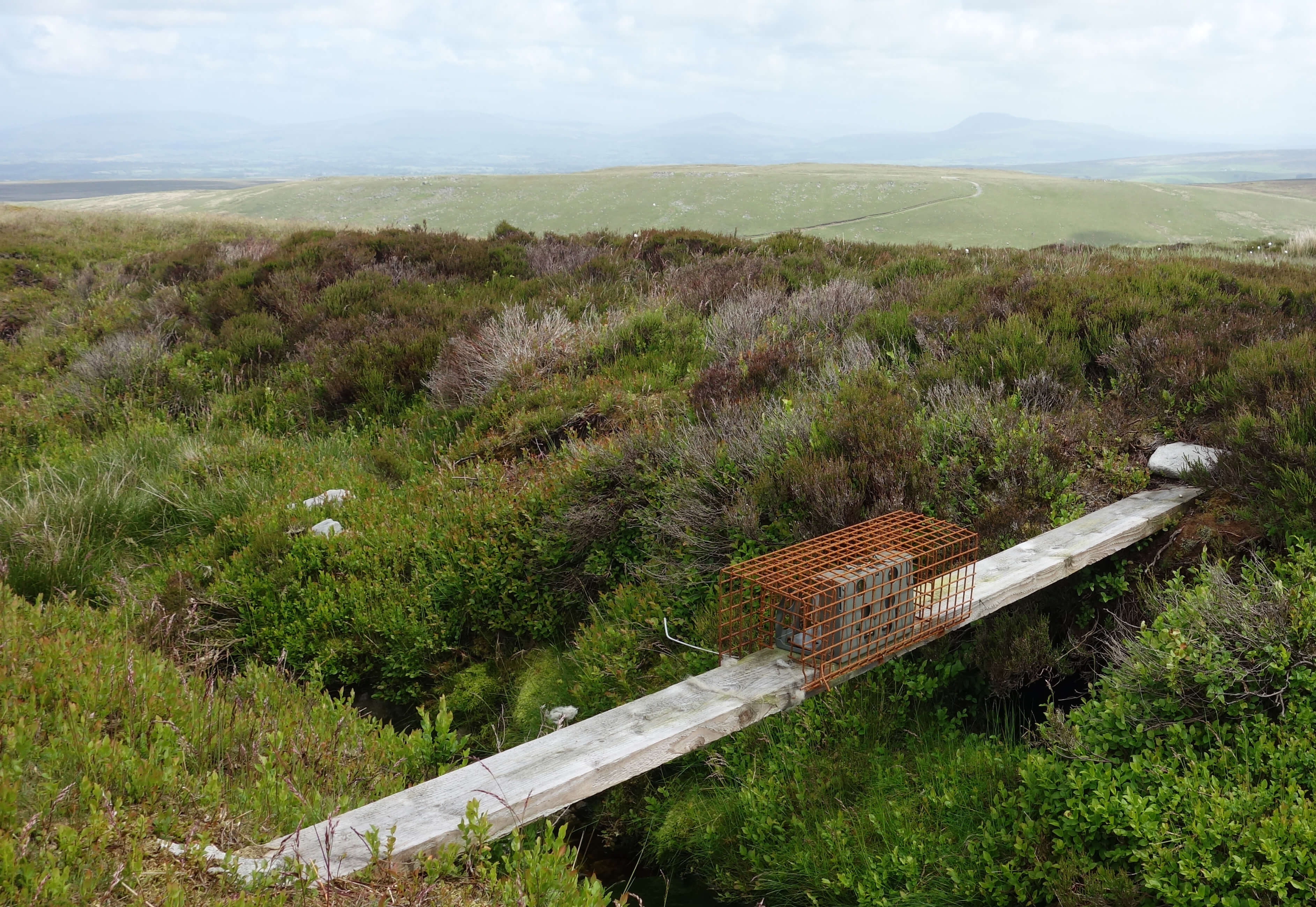
By the way, if you see one of these (below) on the moors
and are puzzled as to what it is, don't poke it
with your finger, unless you're prepared to leave your finger behind.
It's a trap for predators such as weasels, to protect the grouse.
(Whernside and Ingleborough are just visible in the distance.)
Date: June 10th 2022
Start: SD601638, near Barkin Bridge (Map: OL41)
Route: S, SE - High Salter - E, SE on Hornby Road - Alderstone Bank
- S - ford over River Roeburn - SW - Brown Syke - SE for half a km - and back
Distance: 10 miles; Ascent: 375 metres
Home
Preamble
Index
Areas
Map
References
Me
Drakkar
© John Self, Drakkar Press, 2018-

Top photo: The western Howgills from Dillicar;
Bottom photo: Blencathra from Great Mell Fell