
Home
Preamble
Index
Areas
Dales
Hills
Lakes
Places
Reserves
Rivers
Structures
Villages
References
Me
Saunterings: Walking in North-West England
Saunterings is a set of reflections based upon walks around the counties of Cumbria, Lancashire and
North Yorkshire in North-West England
(as defined in the Preamble).
Here is a list of all Saunterings so far.
If you'd like to give a comment, correction or update (all are very welcome) or to
be notified by email when a new item is posted - please send an email to johnselfdrakkar@gmail.com.
28. Broughton Moor, or What's Left of It
It is not easy for a walker to avoid the slate mines and quarries of the Lake District. There were
over 250 of them. I say ‘were’ because only a few of them are still working. On this saunter I
set out not to avoid the slate mines and quarries but on the contrary to seek out Broughton Moor Quarry,
four miles south-west of Coniston. According to the
Burlington Stone webpage, this is Cumbria’s
largest quarry, although different definitions of ‘largest’ allow competing claims. The current status of any quarry is always a matter of doubt, with quarries opening and closing as the demands and costs change. I wandered up to see if Broughton Moor Quarry was still in action.
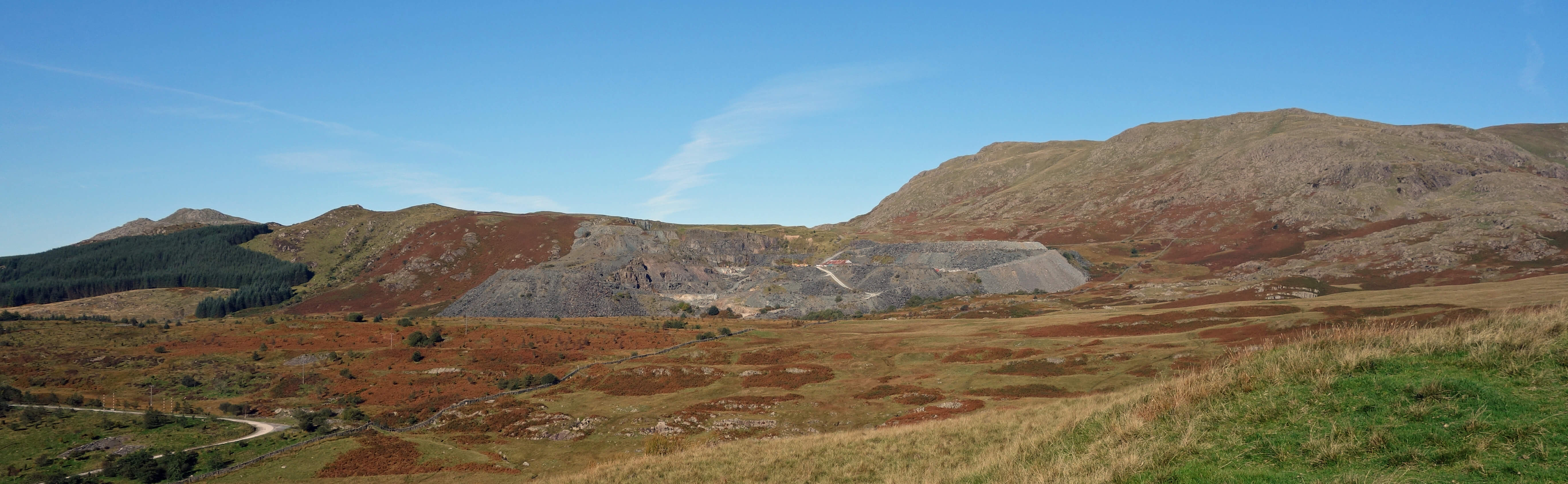
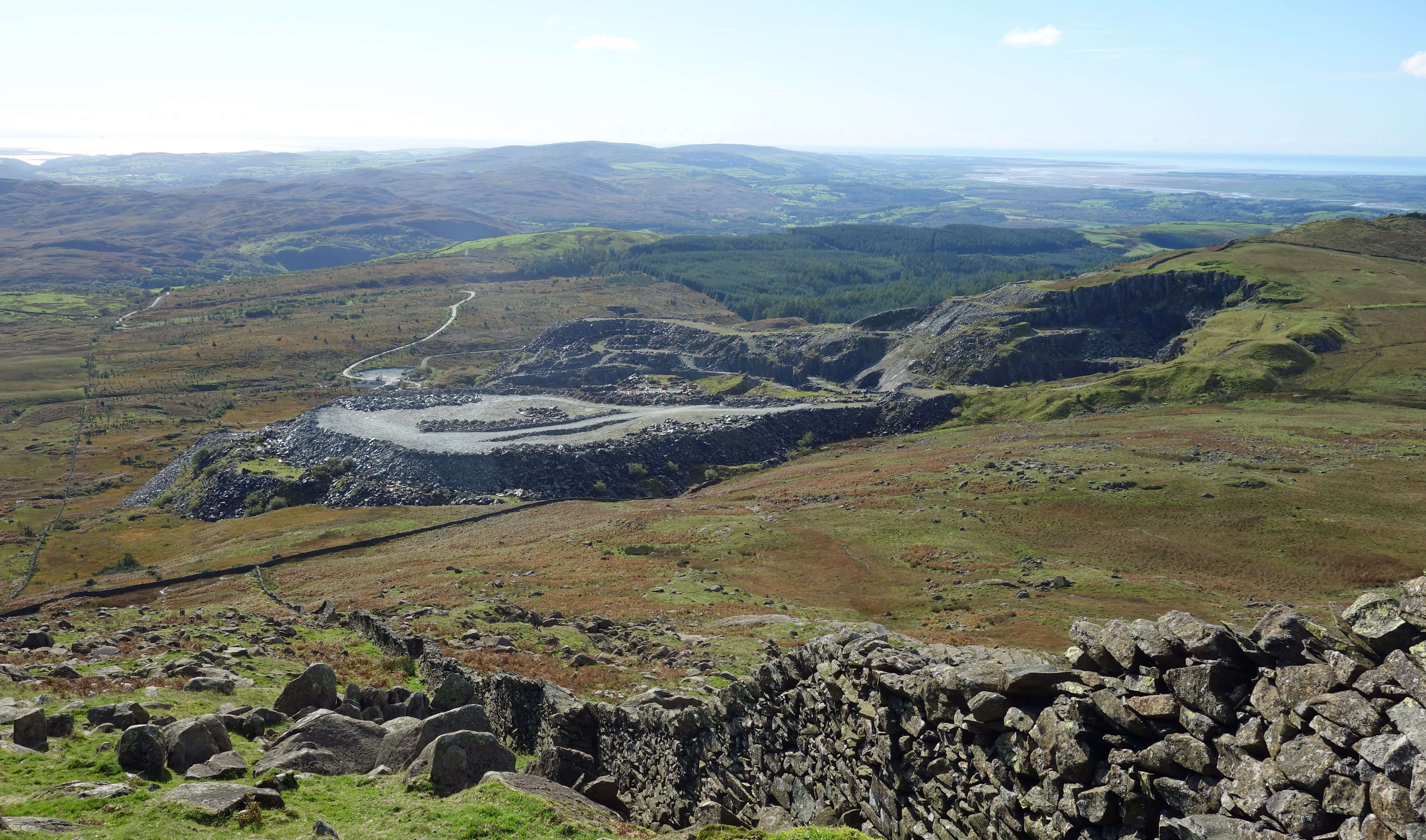
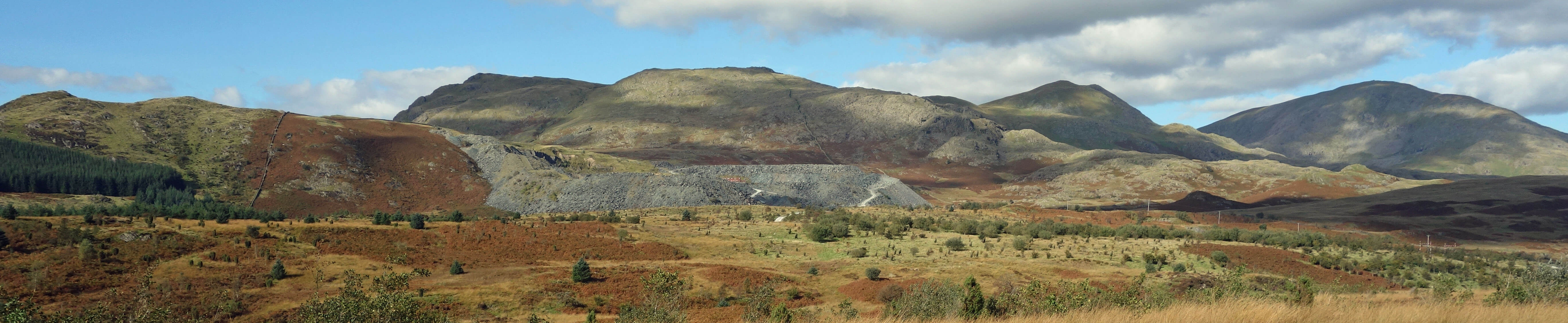
Broughton Moor Quarry
The quarry itself was surrounded by large overspills of discarded rock. Within the rim I
could see half-a-dozen cars and trucks but there was no sight or sound of quarrying activities. I was
most disappointed. I had hoped for a few blasts at least. Perhaps they don’t blast every day but even
so the quarry seemed dormant. The quarry cliff-faces and the main ground area of the quarry
looked as smooth as if they were man-made. This is perhaps not because the quarry-workers are particularly tidy but because slate cleaves so precisely and so evenly.
 Left: Broughton Moor Quarry (the scale may be judged by the trucks in the middle).
This slate is of the Borrowdale Volcanic group, of the Ordovician period of 400-450 million years ago. My naive image of volcanic rock is something hard and knobbly, like basalt.
How come volcanic slate cleaves so well? Well, the answer is partly that it wouldn’t be called ‘slate’ if didn’t cleave well. The question really should be: how come some
volcanic rock cleaves so well? And the answer to that is that not all volcanic rock is formed, like basalt, from cooling lava – some is formed from fine-grained ash, and I assume it is this which becomes slate, through some metamorphic process.
The Broughton Moor Quarry is relatively new. The Romans used Lake District slate, as did several medieval monasteries (Cameron, 2016). The first recorded reference to a Lake District slate mine is in 1283, referring to one at Sadgill in Longsleddale. By the 1600s there were slate mines at Borrowdale, Coniston, Kentmere, Langdale and Tilberthwaite. However, the Broughton Moor Quarry started, in a small-scale way, only in the mid 19th century. It subsequently closed and then re-opened and developed, from the 1920s, into the largest slate mine in England.
The quarry lies on a north-east to south-west band of light green slate that includes, for example, Bursting Stone Quarry near Coniston. Most of the Coniston quarries, familiar to all walkers on the direct route up The Old Man of Coniston, lie on a band of silver-grey slate and are now closed. However, Broughton Moor Quarry is alive, although inactive when I passed by. Its slate is of too high a quality to be used for ordinary tiles, as most slate used to be. It is mainly used for decorative flooring or wall cladding.
I wonder if there are plans to extend the quarry along the band, to create a huge
gash across the Furness fells between Broughton and Coniston. If so I wonder how the UNESCO
World Heritage Committee reviewing the
Lake District’s recently-acquired status as a World Heritage Site (WHS) would react. The
Committee has already placed Liverpool on its list of sites in danger of losing its WHS
status because of the plans to develop its waterfront. It would probably be appalled by the
thought of more mining in the Lake District, since it specifically mentions mining as a potential threat to WHSs.
However, mining is a long-established part of that heritage, longer established even than the sheep-farming tradition that is considered to make a valued contribution. The imperious World Heritage Committee needs something on the agenda for its annual meetings. They’re not junkets, oh no. I picture the committee (with its 21 representatives from Angola … to Zimbabwe) earnestly pontificating on the slate mines of Furness. Anyway, I admit to a certain fondness for quarries, especially ones that are making a lot of noise. They add authenticity and provide ‘proper jobs’. Not everybody in the Lake District can make a living by selling Mrs Tiggy-winkle dolls.
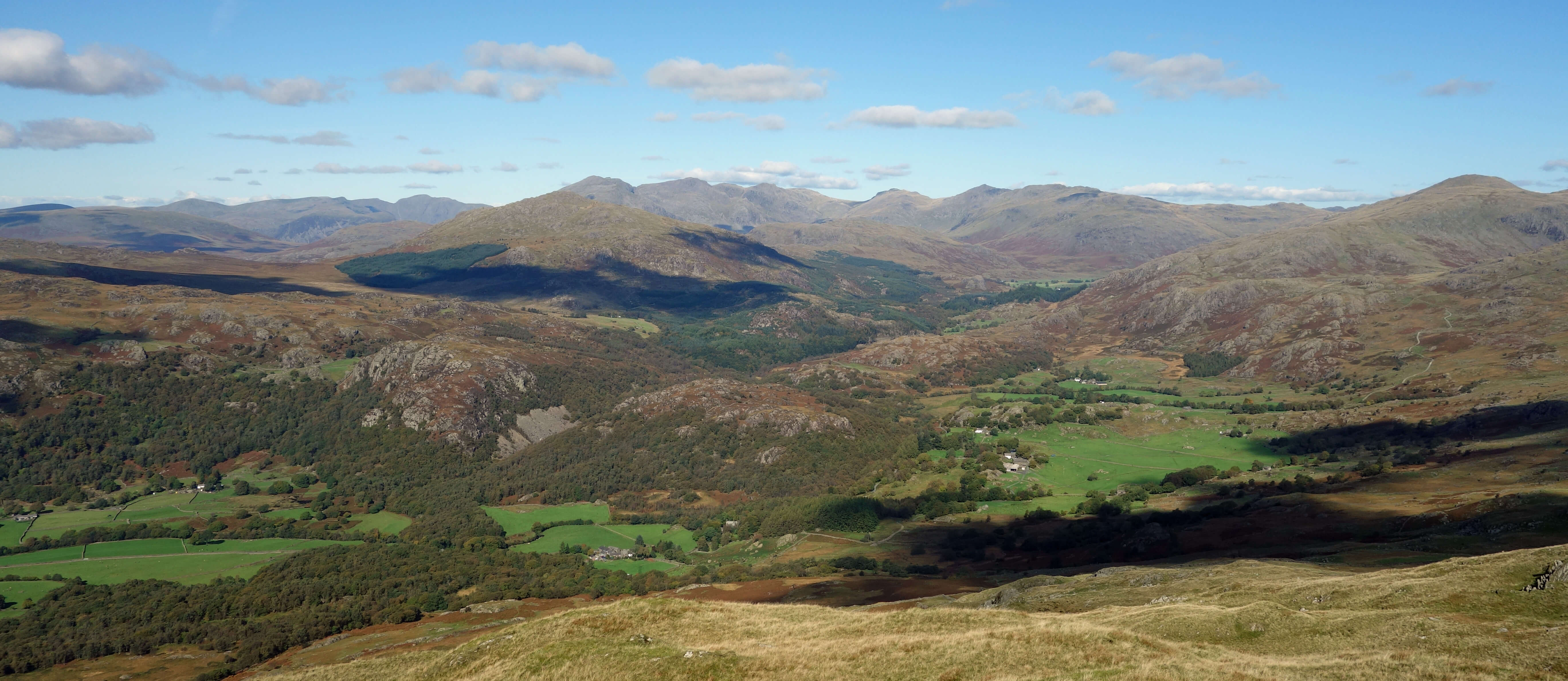
As I climbed White Maiden (608 metres) I found that I was lacking in energy. With no path, it was
a scramble over rocks and bracken, head down, with little view all the way. However, it all seemed
worth the effort at the top (a great phewpoint!
[19]) as the vista opened out,
with the Scafell peaks ahead. It was a bright clear day, with views of the Isle of Man, across
Morecambe Bay to Blackpool, and to Ingleborough and the Pennines in the distance, of Pillar, Scafell,
and Bowfell in the middle distance, and of Black Combe, Dow Crag and The Old Man of Coniston nearby.
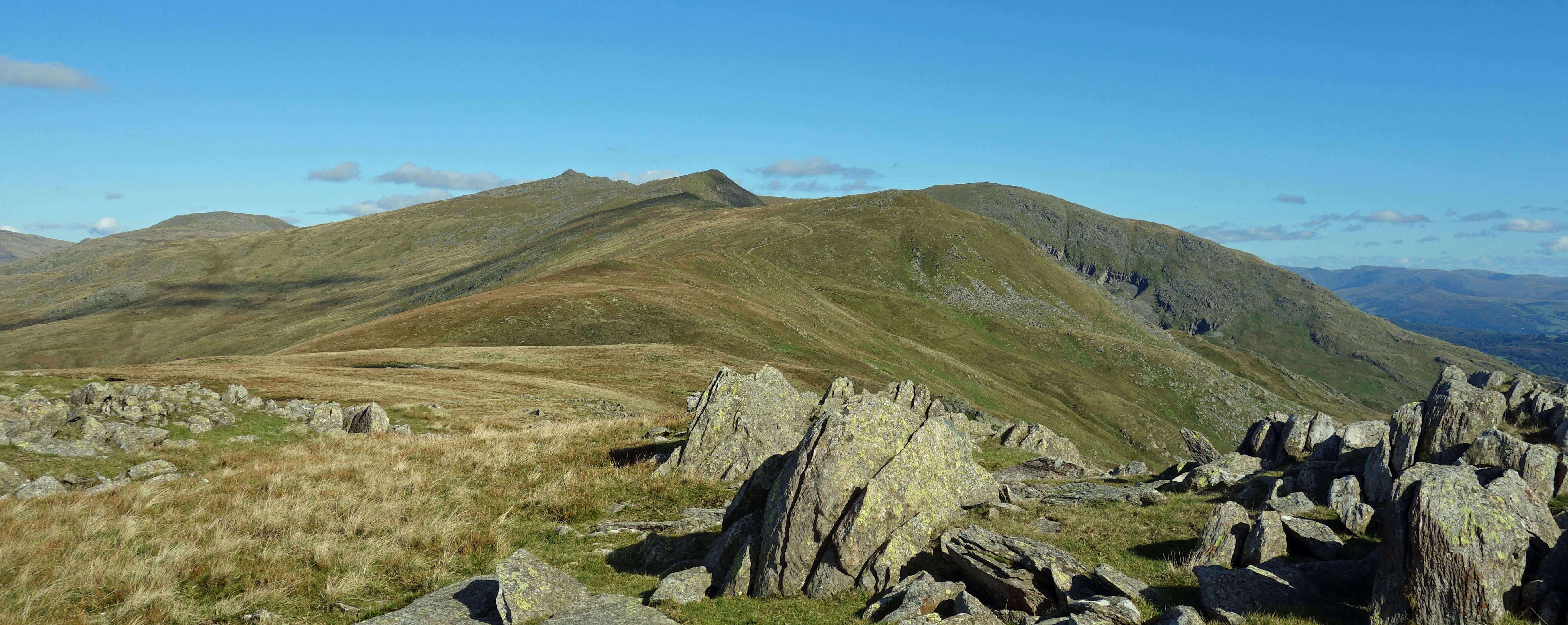
Dow Crag and The Old Man of Coniston from White Maiden
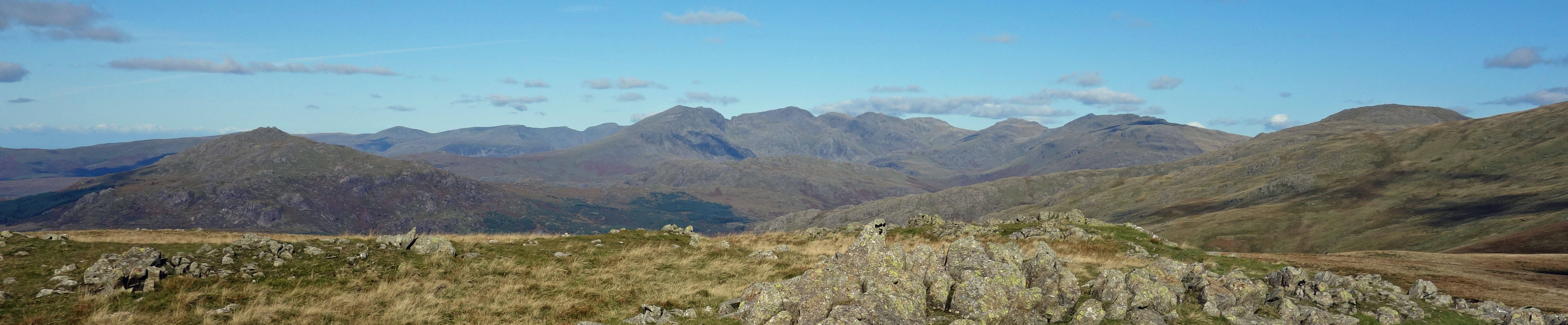
The Scafells from White Maiden
Here I would like to say thank you to our indefatigable friend, Mr Wainwright – not for his catalogue of 214 peaks
(everybody has thanked him for that) but for not including White Maiden in his list (Wainwright, 1955-66).
He didn’t even include it in his subsequent list of ‘outlying fells’ (Wainwright, 1974). He considered the
Walna Scar track from Coniston to Seathwaite to be the southern limit of his Lake District even though it is
six miles north of the National Park boundary. He described the moor south of Walna Scar (the one that I had trekked
across) as “featureless and dreary”.
It is comments like this that lead me to feel that Wainwright’s much-vaunted love of Lakeland was
too narrow and too obsessive. He sought to provide meticulous details of scrambles up the highest peaks.
He devoted thirty pages to The Old Man of Coniston and Dow Crag but to him the nearby Broughton Moor was
dreary and White Maiden was of no account. It is only my opinion, of course, but the moor-grass, autumn
bracken, scattered rocky scars, squelchy bits, sheep, birds (including snipe), flowers (no doubt more in summer),
antiquities, views, and, yes, quarries, old and new, make this region perfectly characteristic of Lakeland. Still, he helped to ensure that I had White Maiden and its views all to myself.
Now invigorated, I walked over to White Pike (598 metres), where the view is perhaps even better as more of the
enchanting Duddon valley is revealed. And then on to Caw (529 metres), which feels higher to climb than it looks like it
should. Here I sat with my sandwiches and a bird’s eye view of the valley. Nowadays, Google Earth has taken away
some of the magic of aerial views, but Google Earth is not live. I could watch the gentle activity in the valley – farmers
in fields, campers coming and going, cars slowly moving along the Duddon valley and crawling up the Hardknott Pass (although, on reflection, that was probably from White Maiden).
The Duddon valley
From Caw I walked to Stephenson Ground, over the River Lickle, through the forest of
the Postlethwaite Allotment, across a narrow
bridge at derelict Appletree Worth, along a forest track, to emerge on Hummer Lane near the quarry entrance. On the road a cyclist stopped to say “that’s a cracker, isn’t it?” as he admired the view of The Old Man. I reflected that over the quarry I could see White Maiden and White Pike where three hours ago I was admiring even better views of The Old Man and much else besides. The quarry was still quiet.
Broughton Moor Quarry, White Pike, White Maiden, Dow Crag and The Old Man of Coniston
Date: September 28th 2018
Start: SD271935, layby on A593 just south of Old Rake (Map: OL6)
Route: NE, W, N up Green Rigg Bank – NW – White Maiden – W –
White Pike – SW – Caw – S, SE – Stephenson Ground, Appletree Worth – SE, NE, E along Hummer Lane, SW - layby
Distance: 9 miles; Ascent: 600 metres
Home
Preamble
Index
Areas
Dales
Hills
Lakes
Places
Reserves
Rivers
Structures
Villages
References
Me
© John Self, 2018-

Top photo: The western Howgills from Dillicar;
Bottom photo: Blencathra from Great Mell Fell