
Home
Preamble
Index
Areas
Dales
Hills
Lakes
Places
Reserves
Rivers
Structures
Villages
References
Me
Saunterings: Walking in North-West England
Saunterings is a set of reflections based upon walks around the counties of Cumbria, Lancashire and
North Yorkshire in North-West England
(as defined in the Preamble).
Here is a list of all Saunterings so far.
If you'd like to give a comment, correction or update (all are very welcome) or to
be notified by email when a new item is posted - please send an email to johnselfdrakkar@gmail.com.
27. The Footpaths of Anglezarke Moor
There seems to be no end to the Associations, Authorities, Boards, Commissions, Committees,
Councils, Groups, Societies, and Trusts that are valiantly trying to safeguard our environment.
So how come our environment is in such a pickle? On this outing I came across another Society
new to me. I had walked across Anglezarke Moor, passing the
Pike Stones
(a Neolithic chambered long burial cairn),
the Devil's Ditch
(an extended Neolithic boundary), and
Round Loaf
(a late Neolithic or Bronze Age tumulus). Where would be without our
dedicated antiquarians? Without them, I am sure that I would pass almost all such structures without noticing anything special.
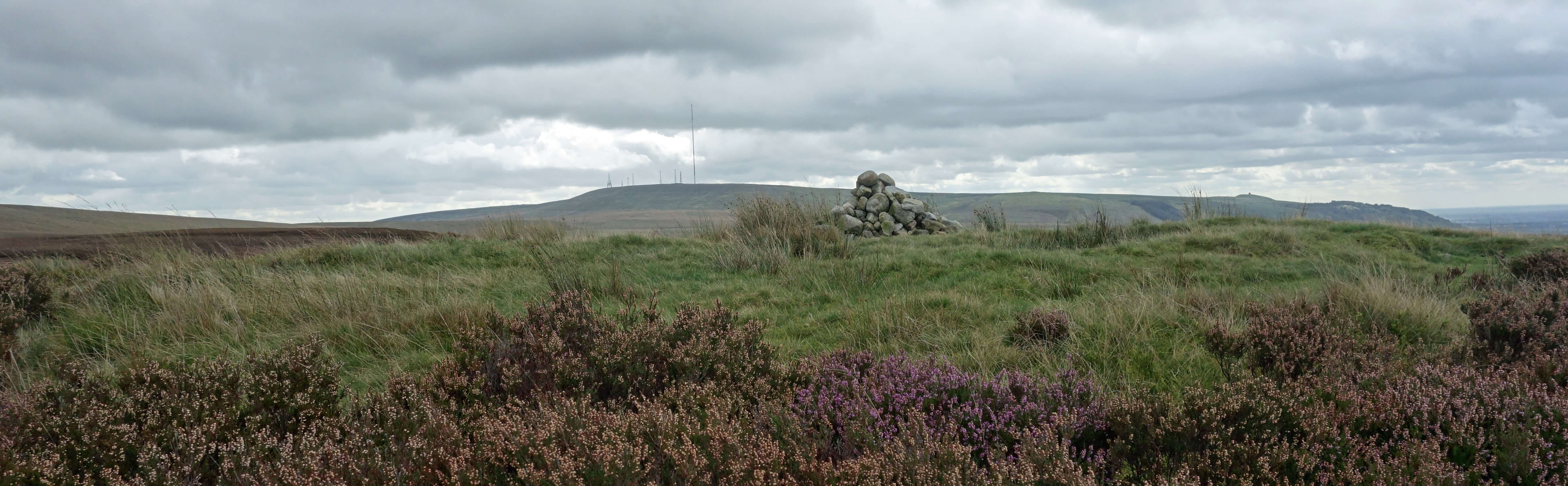
Round Loaf, with Winter Hill in the distance
At the top of Great Hill (not really that great: it’s only 381 metres) I found a sign
erected by the Peak & Northern Footpaths Society (PNFS). A fine sign it is too – metallic,
green with white letters, rectangular and with a logo top left, a number (527) and a
date (2016). Perhaps it’s a bit over the top – or at least too near the top.
A sign would be more useful where we might go astray: I doubt that many people
reach the top of Great Hill having lost their bearings. But I must not quibble.
The PNFS says that it is “promoting the interests of public footpath users
in the North Midlands and North West of England”. Well, that includes me
and I must therefore be grateful to it. Why haven’t I come across it before?
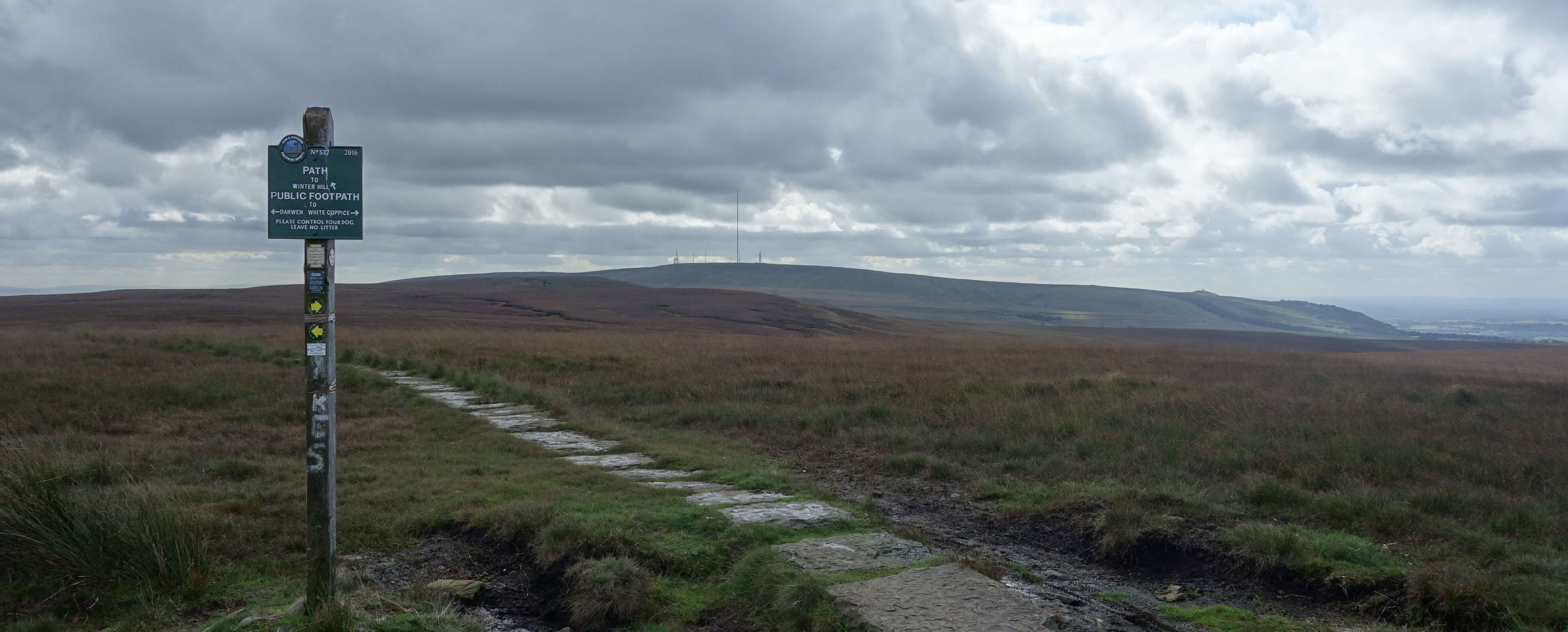
On Great Hill, with the PNFS signpost
I left Great Hill setting off south along a path of large flagstones that somebody (PNFS?)
has considerately laid here. In a stiff breeze, I sailed along, compared to the plod over
the boggy moor. There was little to detain me. The nearby moors were of no particular
interest and the distant views were not exceptional, although I could make out the outline,
through the moisture in the air, of the Welsh mountains. As I walked along Redmond's Edge
the view straight ahead was
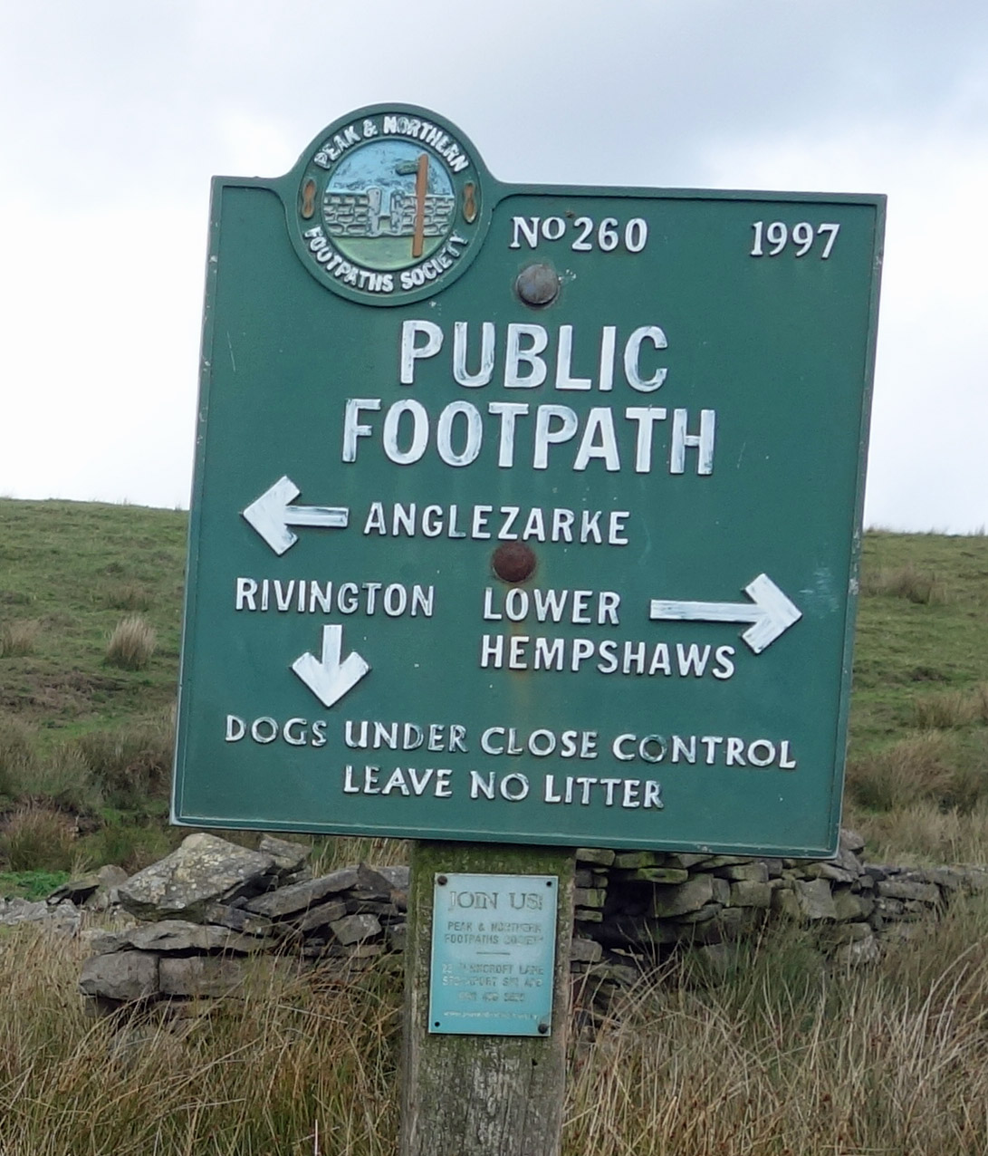
dominated by the multitude of aerials on Winter Hill. I turned west at Will Narr, and walked past Higher and Lower Hempshaw’s, which are both derelict and have been so for some time, judging by how little is still standing. I was tempted to avoid the damp-looking Sam Pasture by following the track visible to the north but then I would have missed almost treading upon a snipe. At Simms (also long derelict) I found another PNFS sign (number 260, dated 1977).
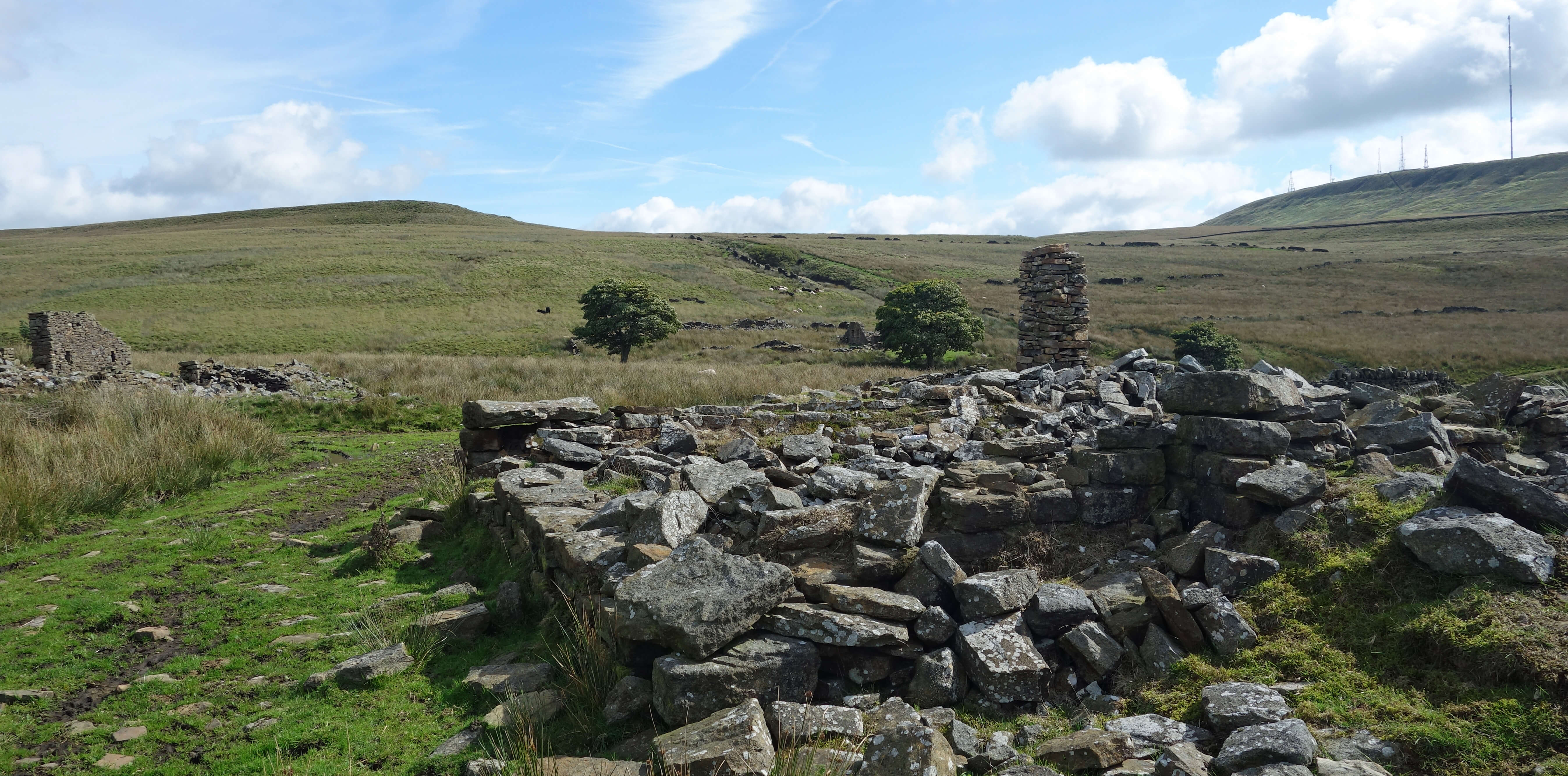
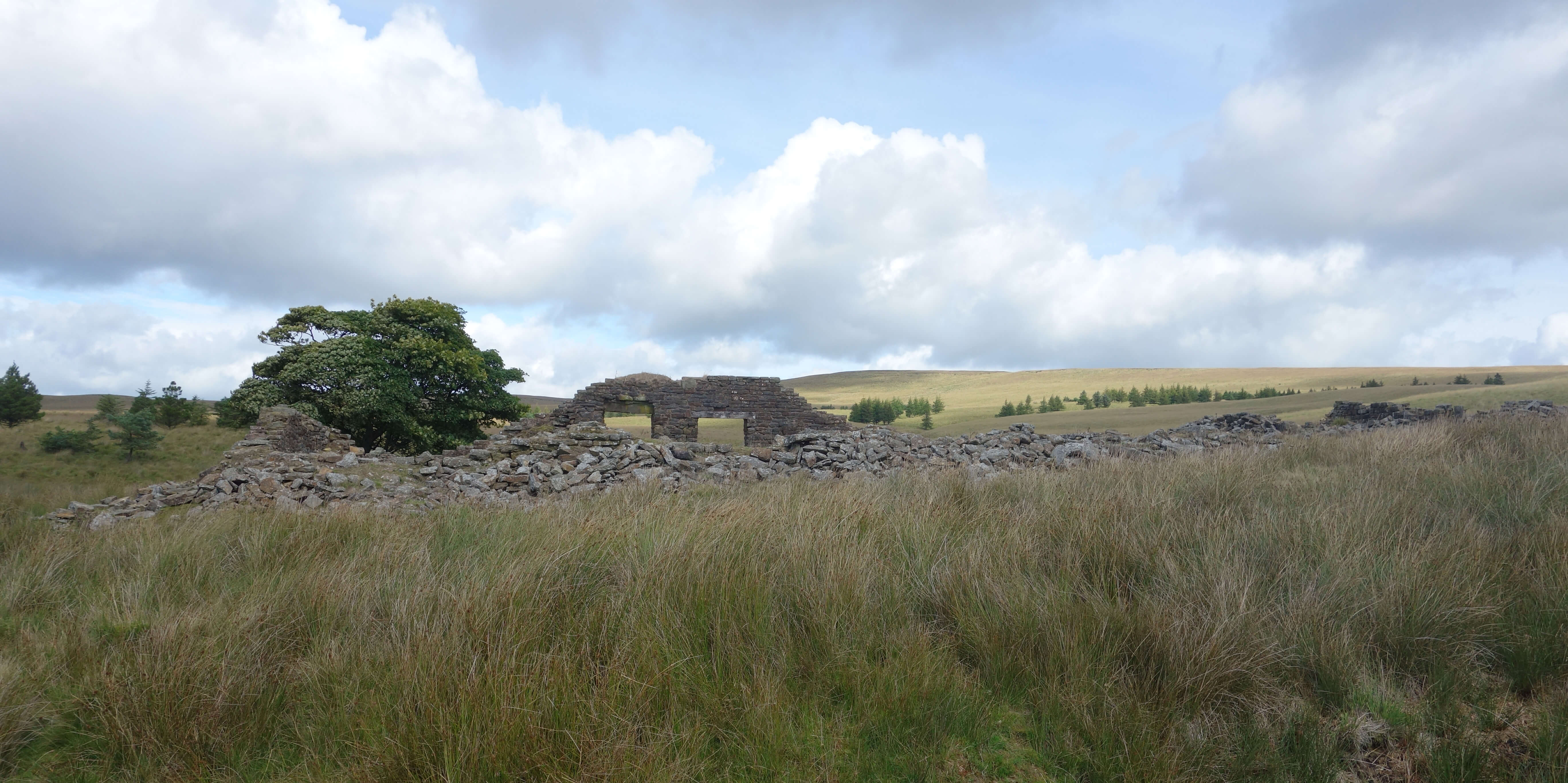
Left and Right: The ruins of the Hempshaw's.
 I have now studied the
Peak & Northern Footpaths Society
website and I conclude that the reason I had not heard of it is that its notion of the ‘North West of England’ does not coincide with mine. It has erected nearly 500 signposts and the most northerly of them is at Lowgill, between Lancaster and Settle (and that is the only one more northerly than where I live). It has no signs within the Lake District and Yorkshire Dales. The large majority are in the Peak District. This reflects its history. The Society was formed as The Peak District and Northern Counties Footpaths Preservation Society in Manchester in 1894 and is said to have evolved from The Manchester Association for the Preservation of Ancient Public Footpaths of 1826. It claims to be “the oldest surviving regional footpath society in the UK”. So, for nearly 200 years the Society has been worrying about our footpaths.
I have now studied the
Peak & Northern Footpaths Society
website and I conclude that the reason I had not heard of it is that its notion of the ‘North West of England’ does not coincide with mine. It has erected nearly 500 signposts and the most northerly of them is at Lowgill, between Lancaster and Settle (and that is the only one more northerly than where I live). It has no signs within the Lake District and Yorkshire Dales. The large majority are in the Peak District. This reflects its history. The Society was formed as The Peak District and Northern Counties Footpaths Preservation Society in Manchester in 1894 and is said to have evolved from The Manchester Association for the Preservation of Ancient Public Footpaths of 1826. It claims to be “the oldest surviving regional footpath society in the UK”. So, for nearly 200 years the Society has been worrying about our footpaths.
I assume that PNFS is independent of the national
Open Spaces Society,
which was founded in 1865 as the Commons Preservation Society, which amalgamated with the National Footpaths Preservation Society in 1899. Although the last-mentioned society disappeared in name, there are still many local ‘footpath preservation’ societies in England. Perhaps we need a footpath preservation society preservation society. Anyway, I am sure that they all do a worthy job in view of the problems that footpaths face – some natural (such as erosion, subsidence and landslips) and others man-made (such as obstructions like barbed wire, electrified fences, crops, buildings and gates).
 However, judging only from its website, the PNFS seems somewhat geeky to me,
and I should know. Why carefully number the signs, as though they are works
of art to be collected? Why list them (40 bridges, 8 fingerposts, 5 plaques,
479 signposts, 2 toposcopes) so lovingly, all with 10-figure grid references
and photographs? Why revere the oldest of them, as though they are
valued antiquities? Is PNFS more fixated on the footpath ‘furniture’ (the
signposts and so on) than on the footpaths themselves? How does a relatively
small group of volunteers “monitor, protect, and improve the footpath network”
of such a large area? How does it decide where to erect its (relatively
expensive) signs? It may seem that 479 signposts is plenty but they spread thinly over all our footpaths. I said above that PNFS was formed in 1894 but the website insists on details – it “was formed officially at a meeting held at 7pm on Thursday 16th August 1894 in the Young Men's Christian Association Hall, Peter Street, Manchester”.
However, judging only from its website, the PNFS seems somewhat geeky to me,
and I should know. Why carefully number the signs, as though they are works
of art to be collected? Why list them (40 bridges, 8 fingerposts, 5 plaques,
479 signposts, 2 toposcopes) so lovingly, all with 10-figure grid references
and photographs? Why revere the oldest of them, as though they are
valued antiquities? Is PNFS more fixated on the footpath ‘furniture’ (the
signposts and so on) than on the footpaths themselves? How does a relatively
small group of volunteers “monitor, protect, and improve the footpath network”
of such a large area? How does it decide where to erect its (relatively
expensive) signs? It may seem that 479 signposts is plenty but they spread thinly over all our footpaths. I said above that PNFS was formed in 1894 but the website insists on details – it “was formed officially at a meeting held at 7pm on Thursday 16th August 1894 in the Young Men's Christian Association Hall, Peter Street, Manchester”.
Still, the PNFS and like-minded Societies do at least prompt us to reflect upon our footpaths. Who is legally
responsible for erecting and maintaining signposts? Or is it up to
volunteers? Is it illegal to remove or deface a signpost? Local authorities
have a statutory duty to indicate the route of a right of way where it leaves a metalled
road but I don’t know what the law says once we are away from the road – probably nothing,
judging by the variety and arbitrary nature of the signposts I see. The PNFS
website says that “the law requires that local authorities consult us when they
consider diverting or closing a right of way”. That ‘us’ is ambiguous.
Do they mean ‘us, the public’ or ‘us, the PNFS’? It surely cannot be the latter. My local authority is just within what PNFS defines as ‘our region’ but I doubt that it has even heard of PNFS. Why should it
consult a group of volunteers based in Stockport?
The more I read about PNFS and its signposts the less I like them. I see that PNFS has recently
placed its first signposts, eight of them, in the Forest of Bowland (three by Brennand Farm, three
at Whitendale and two by Langden Brook).
Who does PNFS think it is, muscling into the relative wilderness of Bowland with its gaudy intrusive
eyesores? I hope we can prevent PNFS invading the Lakes and Dales.
I know that “dogs under close control leave no litter”.
I don’t want PNFS encouraging dog-owning, litter-bearing, signpost-needing Mancunians to Bowland. Bowland is for walking connoisseurs, like me.
I note that only two of the fourteen Officers and Trustees of PNFS are women. That is
commendable. PNFS is a group of volunteers and I expect that, like most charities, it is
short of them. However, the women of the North Midlands and North West England have more sense. The PNFS may fondly number its signposts but surely it is the days of signposts that are numbered. We have sat-navs telling drivers where to go. It is only a matter of time before walkers will be able to plug into their ear a virtual co-walker who will tell them where to go.
From Simms I crossed Lead Mines Clough, which I didn't have time to explore although
I did notice a memorial to six airmen killed in a 1943 crash on these moors.
I understand that up-clough, where a lead mine flourished in the 18th and 19th centuries,
is a rocky gorge with attractive waterfalls.
Date: September 13th 2018
Start: SD619175, on Moor Road (Map: 287)
Route: E, SE – Pike Stones – NE – Rushy Brow (where I realised
I’d forgotten to turn the car lights off!) – W, back to Moor Road – NE – Hurst Hill, Round Loaf, Great
Hill – S over Redmond's Edge – Will Narr – W – Higher Hempshaw's, Simms, Lead Mines Clough – NW – Jepson's Gate, Moor Road
Distance: 8 miles; Ascent: 190 metres
172(+914)/2250
Home
Preamble
Index
Areas
Dales
Hills
Lakes
Places
Reserves
Rivers
Structures
Villages
References
Me
© John Self, 2018-

Top photo: The western Howgills from Dillicar;
Bottom photo: Blencathra from Great Mell Fell