
Home
Preamble
Index
Areas
Dales
Hills
Lakes
Places
Reserves
Rivers
Structures
Villages
References
Me
Saunterings: Walking in North-West England
Saunterings is a set of reflections based upon walks around the counties of Cumbria, Lancashire and
North Yorkshire in North-West England
(as defined in the Preamble).
Here is a list of all Saunterings so far.
If you'd like to give a comment, correction or update (all are very welcome) or to
be notified by email when a new item is posted - please send an email to johnselfdrakkar@gmail.com.
50. With the Lune from Kirkby Lonsdale
A circle has no point. A long circular walk, as most of my saunters have been, involves a considerable
expenditure of effort and time but leaves me exactly where I started. A linear walk from A to B at least achieves
something, that is, the transfer of myself, by my own legs, to somewhere different. And if B is somewhere I’d
like to be – say, home – all the better.
The saunters that I have regaled you with in Saunterings are but the tip of an iceberg.
They generally involve an expedition to somewhere in
North-West England but they are supported by numerous local walks to keep the legs
in walking order. Some of them are what I call ‘tip-outs’, where I am taken, either by public transport
or by Ruth on her way to somewhere, and deposited by the road-side to walk home. It would become
repetitive if I were to describe all these walks here – but I thought I might add a ‘walking home’
from time to time, such as this one involving a walk back from Kirkby Lonsdale alongside the River Lune.
 From the Kirkby Lonsdale bus stop I headed straight through the Market Square and along Jingling Lane
to the Devil's Bridge. Knowing that I had quite a few miles ahead of me,
I ignored the many charms of Kirkby Lonsdale,
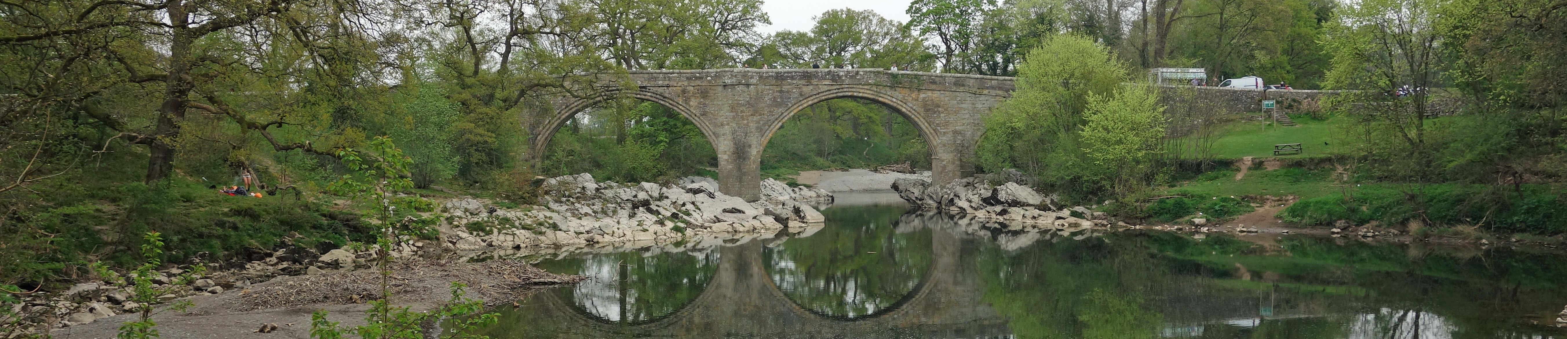
apart from the bridge, which is always worth another look, especially if there is no motorbike convention
on at the time. The bridge is believed to be of the 14th century and has three ribbed arches high above
the River Lune carrying a narrow crossing, once on the Skipton to Kendal route but no longer used as a road, of course.
From the Kirkby Lonsdale bus stop I headed straight through the Market Square and along Jingling Lane
to the Devil's Bridge. Knowing that I had quite a few miles ahead of me,
I ignored the many charms of Kirkby Lonsdale,
apart from the bridge, which is always worth another look, especially if there is no motorbike convention
on at the time. The bridge is believed to be of the 14th century and has three ribbed arches high above
the River Lune carrying a narrow crossing, once on the Skipton to Kendal route but no longer used as a road, of course.
There are a great many Devil's Bridges, including at least another seven in the United Kingdom.
The name tends to be used for old bridges that seem to demand a surprising degree of technical skill, a
skill which, it seems, local legends can only attribute to the devil. However, in order to ensure that
the devil doesn't come well out of the legend, there is usually some ruse involved whereby he receives
his comeuppance. So common and similar are these legends that they form a special category
(number 1191, in fact) in the
Aarne-Thompson-Uther
classification system for folktales.
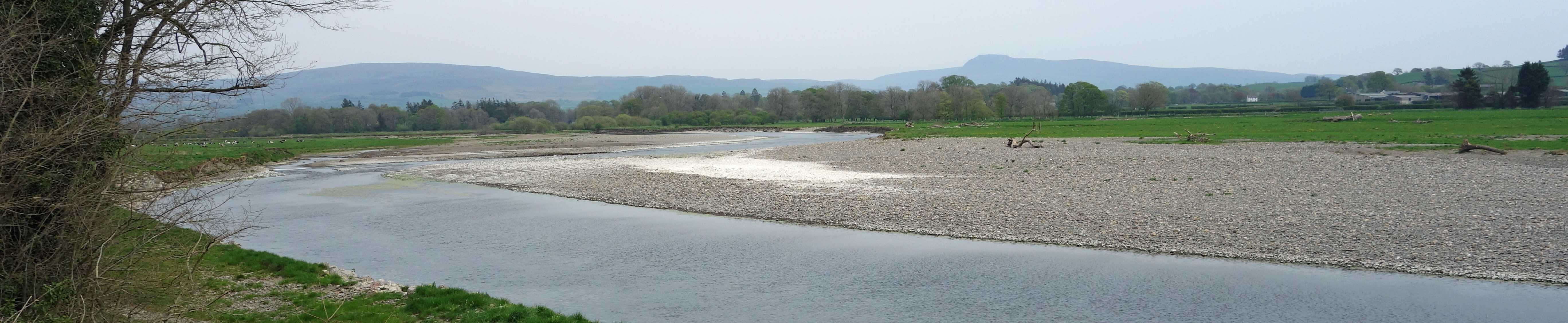
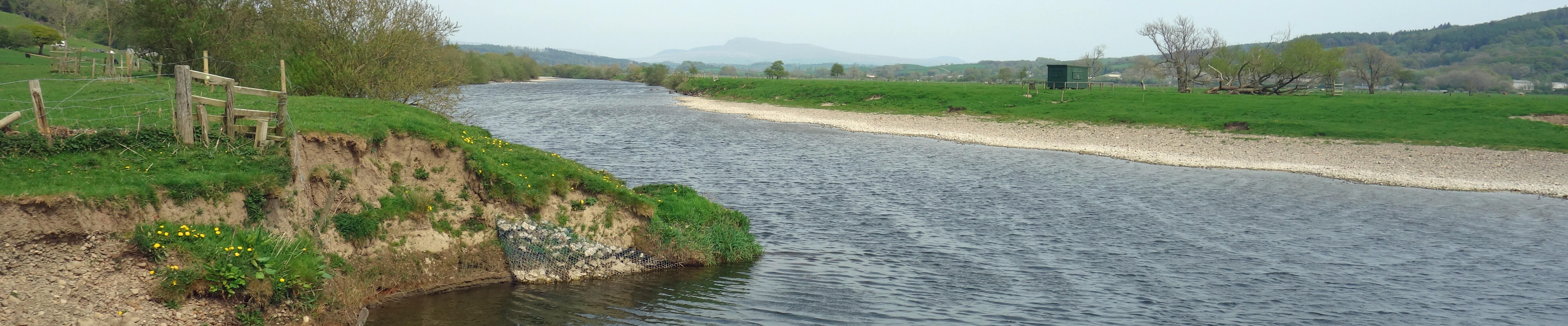
 The river was very low. Stones that were normally underwater were now beached and bleached.
Green sludge was forming in stagnant parts. Rarely can the river have been so low in April.
The river was very low. Stones that were normally underwater were now beached and bleached.
Green sludge was forming in stagnant parts. Rarely can the river have been so low in April.
After half a mile I reached a bridge, but not one for walkers.
The bridge is an aqueduct for water from Haweswater on its way under the Bowland hills to Manchester.
It was built in the 1950s and appears somewhat functional compared to the rather
ornamental 1890s aqueduct (Waterworks Bridge, for Thirlmere water)
to be met later - much later.
How much later I could judge by my first distant view of the Caton windmills, some ten miles away.
The windmills are on the hill above my home village, Brookhouse - and since I know how huge they are and how
tiny they looked now, I could tell that I had far to walk.
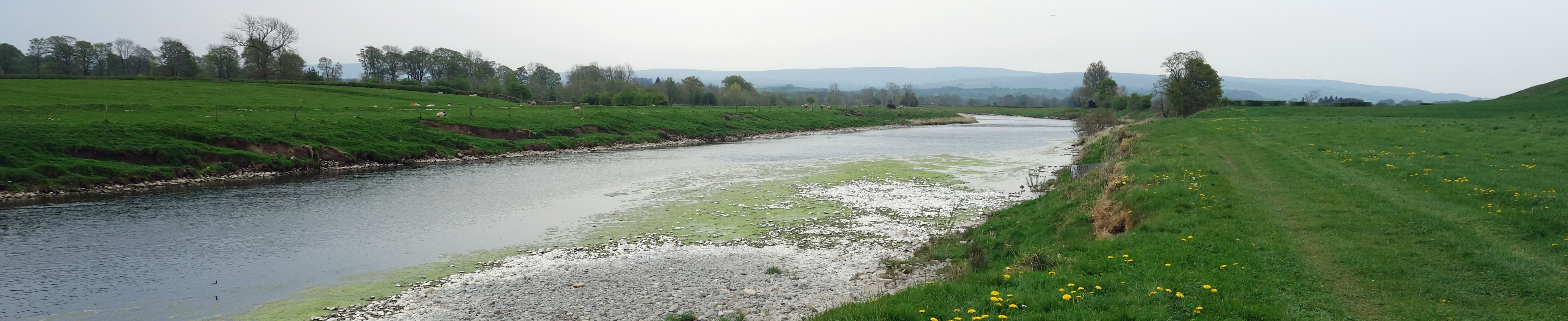
 The path continued close to the west bank of the Lune, passing the village of Whittington, with a view
of Whittington Hall.
Any other walkers from
Kirkby Lonsdale - I passed three - will probably turn off to Whittington and so the next couple of
miles will be in solitude. Leck Beck entered the Lune from the east but could easily be missed because it too had little
water. Here the valley opened out, providing wide panoramas of the Dales hills of Leck Fell,
Whernside and Ingleborough - and, still far ahead, the Caton windmills.
The path continued close to the west bank of the Lune, passing the village of Whittington, with a view
of Whittington Hall.
Any other walkers from
Kirkby Lonsdale - I passed three - will probably turn off to Whittington and so the next couple of
miles will be in solitude. Leck Beck entered the Lune from the east but could easily be missed because it too had little
water. Here the valley opened out, providing wide panoramas of the Dales hills of Leck Fell,
Whernside and Ingleborough - and, still far ahead, the Caton windmills.
I was preceded along the Lune by a group of three little egrets.
I didn't have my binoculars with me and so couldn't tell if they were male or female
(to tell the truth, I couldn't even with binoculars - but as long as little egrets can tell
the difference that's all that matters). Whatever they were, three seems an odd number to
form a group. The last time that I walked here I saw heron (at least one) but not this time.
Are little egret, as welcome as they are, at least to me, displacing heron?
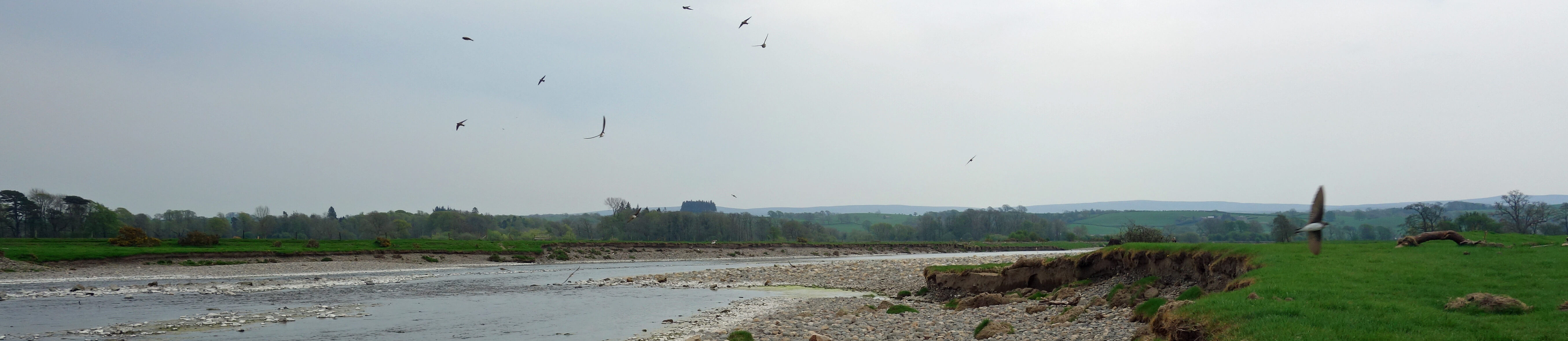 Opposite a large stony beach that had accumulated huge tree trunks washed down in floods
I sat for a while with sand martins. Sand martins had accompanied me all
the way from Kirkby Lonsdale but here they swirled about over the river in some numbers,
disappearing into and emerging from their nests in the bank just along from where I was sitting.
Opposite a large stony beach that had accumulated huge tree trunks washed down in floods
I sat for a while with sand martins. Sand martins had accompanied me all
the way from Kirkby Lonsdale but here they swirled about over the river in some numbers,
disappearing into and emerging from their nests in the bank just along from where I was sitting.
I was pleased to see them all because every year from April 1st I look out for sand martins
and I had only seen a few at my local patch of the Lune and none at all by the Waterworks Bridge
where they normally nest. I was beginning to worry that some harm had befallen them.
But here there were hundreds of them. I am unreasonably fond of sand martins.
Their twittering is so characteristic of the summer Lune and they are one of the first of our
migrants to return to tell us that summer is on its way.
I have no idea why they have abandoned their Waterworks
Bridge nests, if that is the case. I had understood that sand martins returned to their nests
of previous years, which is only sensible since it must be a lot of work for these little
birds to excavate their tunnels.
 As I neared Arkholme I saw, out on the riverside stones, a man scanning the skies with his
binoculars and making notes on his clipboard. I would have liked to chat to him but
he was so determined to pretend that he had not noticed me that I thought I'd better not.
I wonder if he had spotted the jay that I saw in a wood at Arkholme. Probably jays are
common to him but I don't see them in the region as often as I should, judging by the bird books.
As I neared Arkholme I saw, out on the riverside stones, a man scanning the skies with his
binoculars and making notes on his clipboard. I would have liked to chat to him but
he was so determined to pretend that he had not noticed me that I thought I'd better not.
I wonder if he had spotted the jay that I saw in a wood at Arkholme. Probably jays are
common to him but I don't see them in the region as often as I should, judging by the bird books.
Where the River Greta joins the Lune I was reminded that everywhere that I had walked
was within a floodplain and is underwater from time to time. The River Lune itself has changed
course here relatively recently. An 1847 map shows the Lune flowing about 1/4 mile east of where
it now is. Its present course is marked as 'Old Lune' on the 1847 map, indicating that it has
returned to an old route. Today's map marks two other 'Old Lune's. At the moment, the river is
channelled through an arch of the Carnforth-Wennington railway line.
The footpath also passes through an arch, swerves round the motte of the old motte and bailey castle,
cuts across the toe of Arkholme, passes the Ferryman's Cottage, and re-emerges by the Lune.
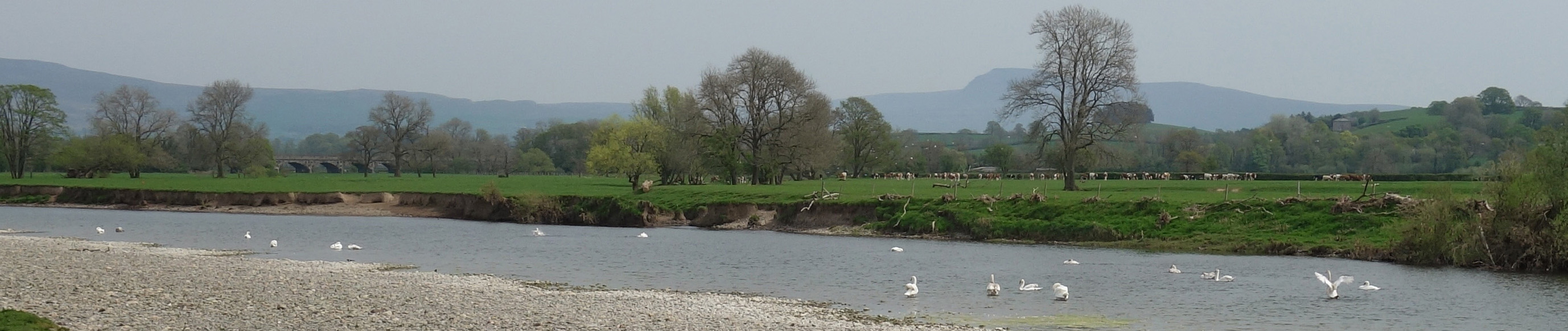 It continued to be peaceful alongside the river until I came upon a group of twenty-one swans and
hundreds of gulls. The gulls all flew up, screeching as one, annoyed that I had disturbed them.
The swans just flapped a wing or two in the water and carried on as they were.
It continued to be peaceful alongside the river until I came upon a group of twenty-one swans and
hundreds of gulls. The gulls all flew up, screeching as one, annoyed that I had disturbed them.
The swans just flapped a wing or two in the water and carried on as they were.
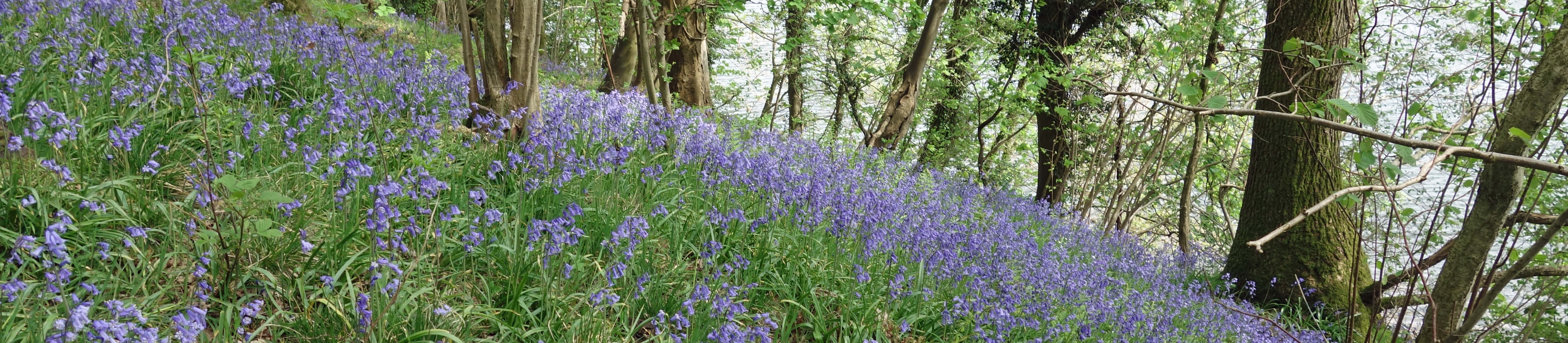
Hereabouts I appreciated that I had chosen wisely in taking this walk in April,
when there's fresh green on the trees and little undergrowth underfoot. The last time
I came this way, in an August/September, it was a distressing scramble trying to locate the path
through dense Himalayan balsam and brambles. This time I could enjoy the bluebells in the shady dells.
As I emerged from one such dell I saw two young deer by the river. They did not see me for some time.
When they did, they became flustered for a while as they realised that they were between the river
and my path. After some to-ing and fro-ing, they eventually glided up the hillside.
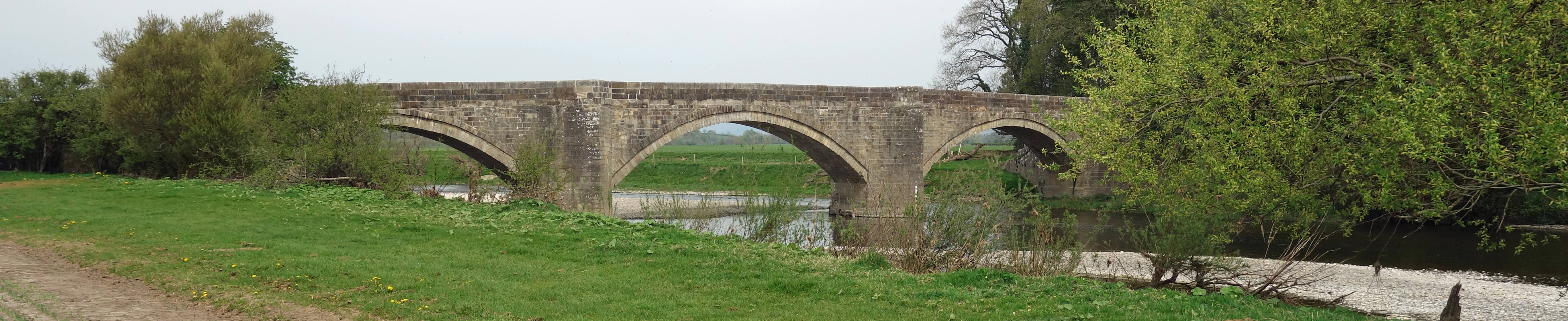 I next came to Loyn Bridge, the only road bridge that I would pass south of Kirkby Lonsdale.
This fine 17th century bridge sits rather squat across the river, unlike the Devil's Bridge which is
perched high above. As a result, flood-waters often bypass the Loyn Bridge to the west.
For example, the record-breaking deluge of December 2015 (Storm Desmond), which reached the
beginning of the arches at the
Devil's Bridge, demolished the
hedges of the fields near the Loyn Bridge, as can still be seen. The Loyn Bridge itself was
so damaged that it was closed for almost five months.
I next came to Loyn Bridge, the only road bridge that I would pass south of Kirkby Lonsdale.
This fine 17th century bridge sits rather squat across the river, unlike the Devil's Bridge which is
perched high above. As a result, flood-waters often bypass the Loyn Bridge to the west.
For example, the record-breaking deluge of December 2015 (Storm Desmond), which reached the
beginning of the arches at the
Devil's Bridge, demolished the
hedges of the fields near the Loyn Bridge, as can still be seen. The Loyn Bridge itself was
so damaged that it was closed for almost five months.
Below Priory Farm, on the opposite bank, I saw two anglers, the only anglers that I saw on this walk.
I realised then that I had seen no sign of fish at all, not a splash nor a ripple.
Perhaps when the river is so low and slow fish rest in whatever deeps they can find: not ideal
conditions to fish, I would guess. The anglers gave me an un-angler-like cheery wave, which made me suspect
that they shouldn't have been fishing at all. Anyway, I doubt that many salmon and trout have
been able to make their way up-river this year yet.
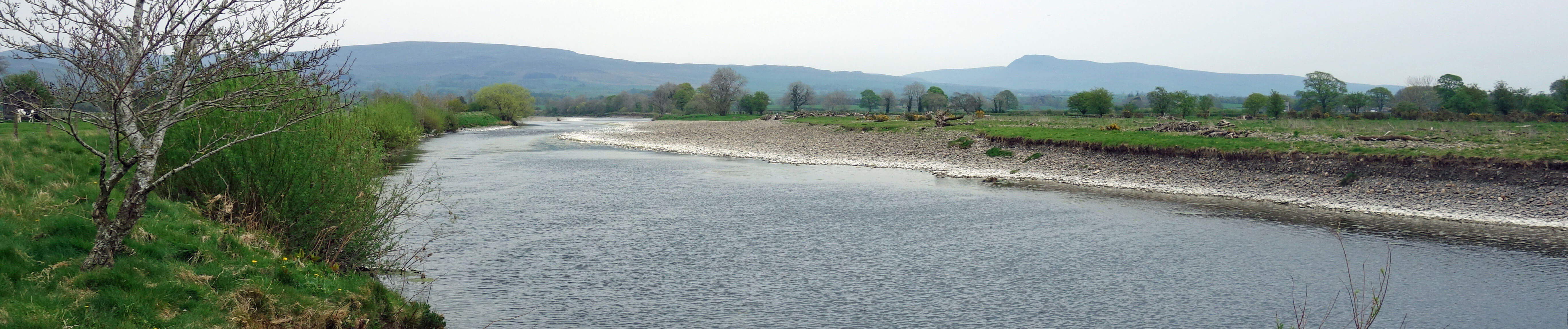
 Behind the River Wenning's entrance to the Lune could be seen
Hornby Castle with
Ingleborough far beyond. Hornby Castle has a long history but what is seen today is a
19th century re-building of it.
Behind the River Wenning's entrance to the Lune could be seen
Hornby Castle with
Ingleborough far beyond. Hornby Castle has a long history but what is seen today is a
19th century re-building of it.
A large flock of oystercatchers (with one or two
lapwing intermingled) waited until I became very close before taking to the air with loud, shrill calls.
I was very much in their territory, alone on the floodplain, away from any habitation.
This is a renowned bird-watching area, especially for over-wintering species, including large
flocks of curlew and lapwing down from the hills.
I cut across to The Snab, as the large promontory south is reserved for cattle and wildlife.
There were a number of geese in the large pond, plus a few cows wetting their feet. The cows were so stationary
that I wondered if they had become stuck there.
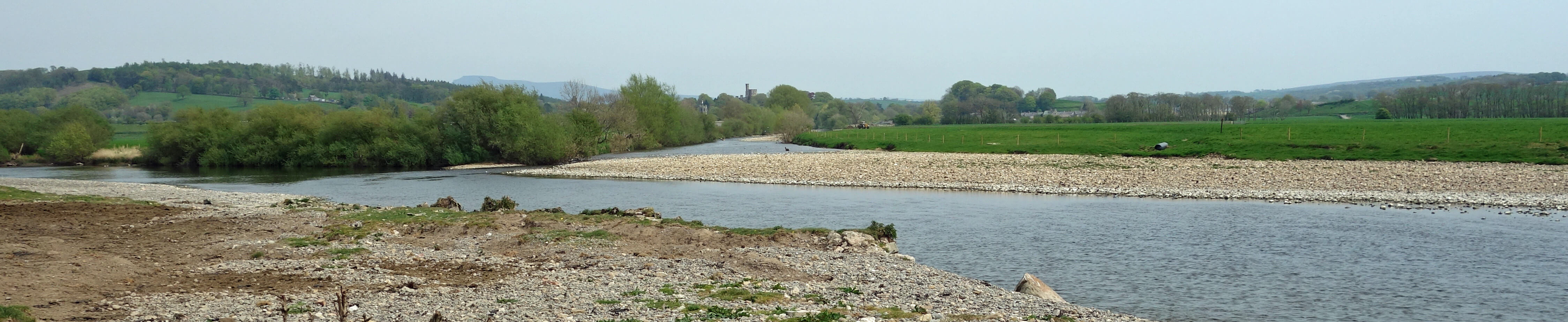
 At Great Close Wood I paused to look at what I think of as 'the island'.
It was no longer an island. There was no water at all flowing on the east side, where the present
OS map indicates most of the river should be. It was all flowing close by the wood.
The 1847 map that I referred to shows no island at all, with the river all to the east of
what is usually an island nowadays. So it seems that the river is in the process of migrating westwards.
Certainly, there are signs of recent erosion all along this west bank.
At one point, past Aughton Barns, there's a stile on the footpath (shown right) that a distracted walker
could step over and find themselves in the river a few feet below.
At Great Close Wood I paused to look at what I think of as 'the island'.
It was no longer an island. There was no water at all flowing on the east side, where the present
OS map indicates most of the river should be. It was all flowing close by the wood.
The 1847 map that I referred to shows no island at all, with the river all to the east of
what is usually an island nowadays. So it seems that the river is in the process of migrating westwards.
Certainly, there are signs of recent erosion all along this west bank.
At one point, past Aughton Barns, there's a stile on the footpath (shown right) that a distracted walker
could step over and find themselves in the river a few feet below.
I heard rumbles that I assumed to be from the quarries of Claughton Brickworks, high
on the moor opposite. I don't think that I've ever heard this noise here before: it must have been brought
to me by the strong wind. I was now more-or-less opposite the Caton windmills, so long my
target. However, I still had some way to go unless I took advantage of the lowness of the
Lune and paddled across it.
 I took a short-cut across the neck of the huge meander of the Lune (as I always do, and
nobody has told me off yet) to enter Lawson's Wood, part of the Aughton Woods Nature Reserve.
This path has only recently been re-opened, after repairs necessitated by landslip damage
during Storm Desmond.
I took a short-cut across the neck of the huge meander of the Lune (as I always do, and
nobody has told me off yet) to enter Lawson's Wood, part of the Aughton Woods Nature Reserve.
This path has only recently been re-opened, after repairs necessitated by landslip damage
during Storm Desmond.
No doubt Aughton Woods have many delights for naturalists but I am content with just four
of its species. There are often deer to be seen here, but not on this occasion.
Badgers are not often seen, of course, unless you make a special expedition in the gloaming, as we have done.
I won't say exactly where they are because there are people who enjoy badgering (or worse) badgers,
encouraged by government policy, without scientific justification, to cull badgers to prevent
the spread of bovine TB.
The woods are noted for their small-leaved lime, here at the northern limits of their range.
However, unless my memory is mistaken, the trees that I had previously identified as small-leaved
lime had not yet unfurled their leaves to help me be sure.
For most walkers the most appealing flora is the bluebell display in spring, and of course I had
skilfully timed my walk home to coincide with it.
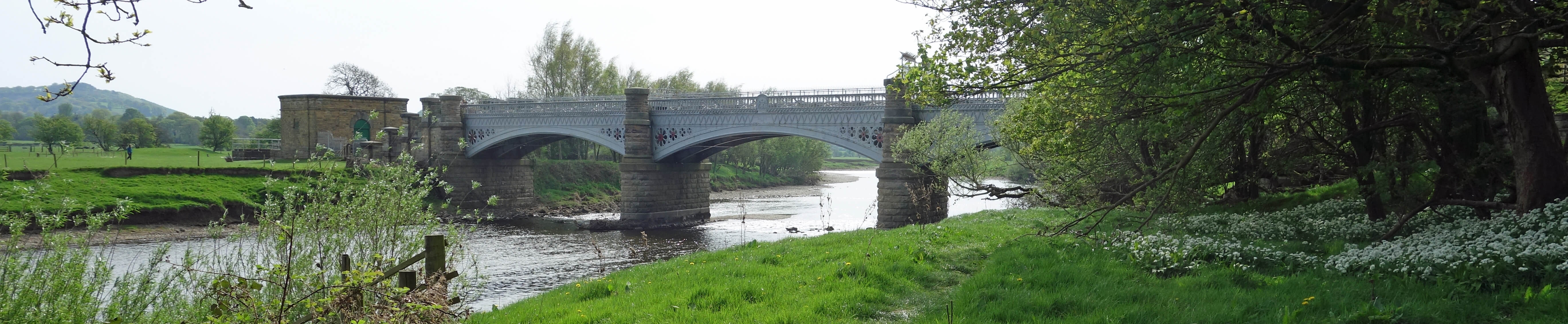 I emerged from the wood to see the Waterworks Bridge and to feel on home territory.
Again there were no sand martins to be seen.
The bridge bears the date of 1892 on its upriver side.
After you cross the bridge you may see carved neatly into the stonework the 1890 and 1891 flood levels.
Maybe the workmen at the time were impressed by these floods.
I wonder how they would react to the flood level for Storm Desmond recently marked towards the top of
the stonework. It is astonishingly higher than their 1890/1891 levels. In fact, the River Lune height
at Caton was measured at 7.95m, way above the previous record of 5.83m.
I emerged from the wood to see the Waterworks Bridge and to feel on home territory.
Again there were no sand martins to be seen.
The bridge bears the date of 1892 on its upriver side.
After you cross the bridge you may see carved neatly into the stonework the 1890 and 1891 flood levels.
Maybe the workmen at the time were impressed by these floods.
I wonder how they would react to the flood level for Storm Desmond recently marked towards the top of
the stonework. It is astonishingly higher than their 1890/1891 levels. In fact, the River Lune height
at Caton was measured at 7.95m, way above the previous record of 5.83m.
I walked across the field and up the lane to home.
One advantage of a 'walk home' like this is that it is obvious - to me and to anyone who asks - what
is involved. A walk in Langdale (like the previous saunter) could mean anything from a stroll between the
car-park and the pub to an assault on Scafell Pike. Anyone local has a good idea what a walk home from
Kirkby Lonsdale entails. There's no better way to end a walk than tea and cake on the lawn.
Date: April 23rd 2019
Start: SD606786, bus stop, Kirkby Lonsdale (Maps: OL2, OL41)
Route: (linear) E – Devil's Bridge – S, SW on west bank
of the River Lune – Waterworks Bridge – S – Brookhouse
Distance: 12 miles; Ascent: 40 metres
Home
Preamble
Index
Areas
Dales
Hills
Lakes
Places
Reserves
Rivers
Structures
Villages
References
Me
© John Self, 2018-

Top photo: The western Howgills from Dillicar;
Bottom photo: Blencathra from Great Mell Fell