
Home
Preamble
Index
Areas
References
Me
Saunterings: Walking in North-West England
Saunterings is a set of reflections based upon walks around the counties of Cumbria, Lancashire and
North Yorkshire in North-West England
(as defined in the Preamble).
Here is a list of all Saunterings so far.
If you'd like to give a comment, correction or update (all are very welcome) or to
be notified by email when a new item is posted - please send an email to johnselfdrakkar@gmail.com.
48. With The Grane
The River Ogden runs for 4.4 miles from the moors east of Darwen and Blackburn to join the River Irwell, according to Wikipedia. However, the Ordnance Survey does not name the watercourse on its West Pennine Moors map, perhaps in protest at the treatment of the river. There may no longer be a River Ogden and there probably never was an Ogdendale. The valley seems to be referred to as Haslingden Grane, or The Grane Valley or The Grane to locals. Haslingden Grane used to be a settlement of 1,300 people but on todayÆs map the name is placed to mark nothing in particular towards the head of the valley.
I noticed that the map shows a VisitorÆs Centre at Clough Head, so somebody believes that there will be visitors. And indeed there were, at least by the time that I returned to the Centre after my walk. The place was buzzing for an April Monday. I suspect that most were relative locals walking their dogs, rather than visitors from afar, like me, but anyway the centre-cum-cafÚ seems a recommendable spot.
I had come to Haslingden Grane mainly to see how it was recovering from perhaps
the most concentrated exploitation of a valley in North-West England. Within a
distance of no more than three miles, there are many instances of our determination
to change (or destroy) our environment to meet our needs. I walked first past
Jamestone Quarry, which today consists mainly of large abandoned lakes although there were
still a few trucks working away, causing the occasional rumble. The map shows many
quarries, most now disused, in the region. I donÆt know what special property the
sandstone/shale hereabouts has that justifies all this quarrying but clearly there was
a demand for it (mainly for road building, I understand) because, according to a notice
at the quarry, at its peak in the late 19th century up to 3,000 men were employed here in the quarrying industry.
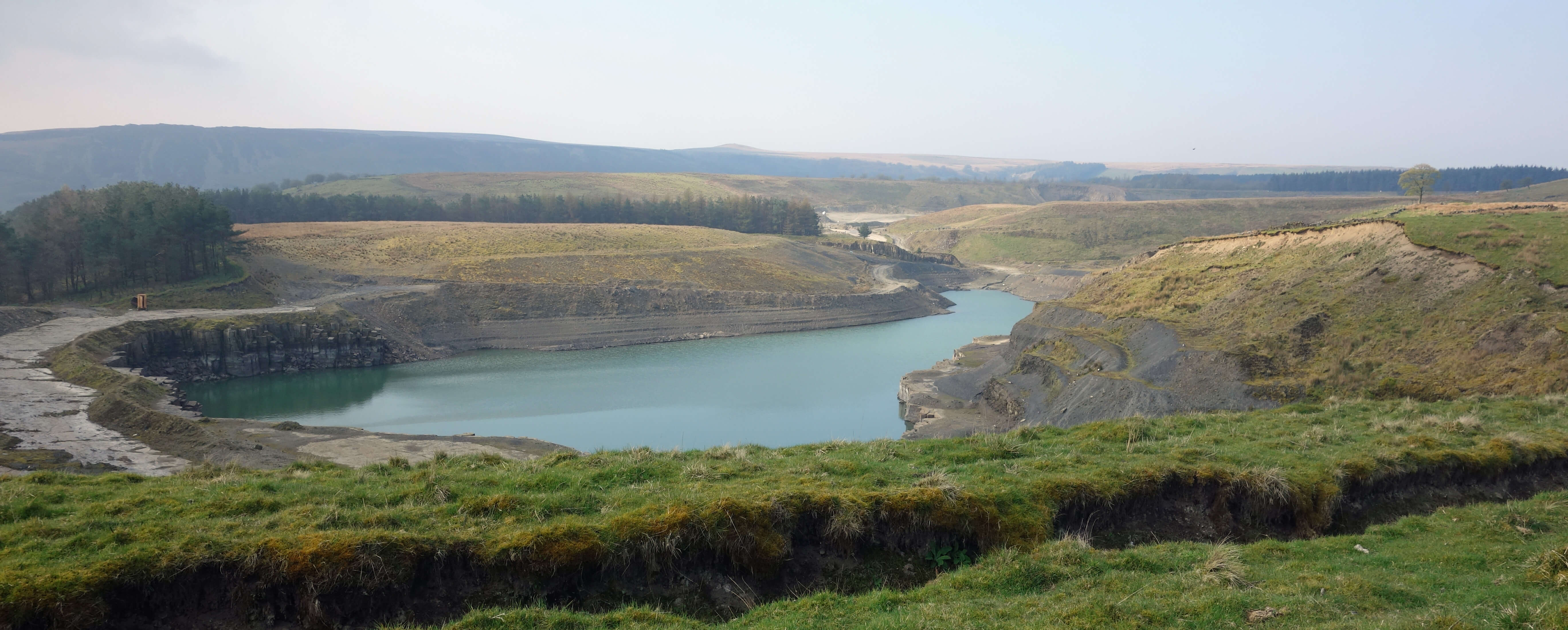
One of the Jamestone Quarry lakes
Continuing east, I passed another large off-blue quarry lake to walk above a conifer plantation. There are a number of such plantations scattered around Haslingden Grane. Perhaps they were added when the reservoirs were built, to filter the water entering them or for aesthetic purposes. I saw no sign that the forests were being harvested. Not all the valley woodlands are conifer forests û there is, for example, a native (it seems to me) wood at the top of the valley, providing a pleasant walk.
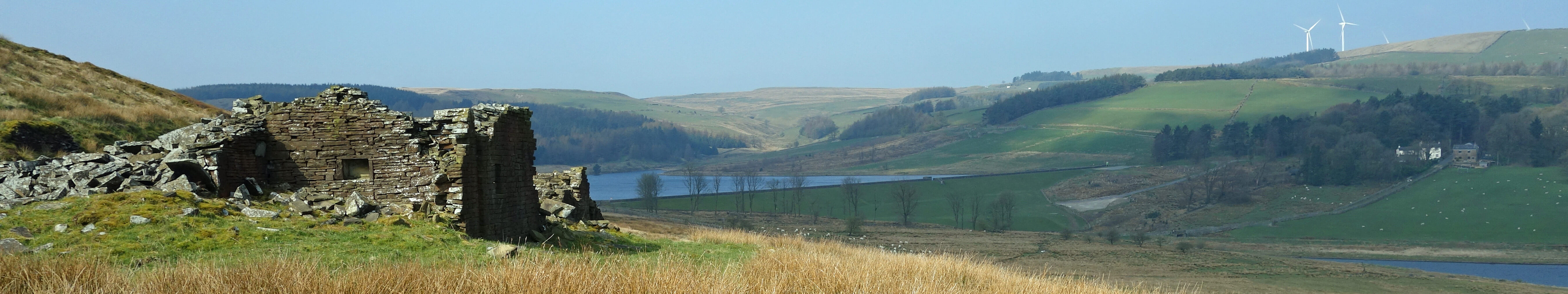
I left the Rossendale Way to drop down past Holden Hall to cross the dam of Holden Wood Reservoir. This is the lowest of the cascade of three reservoirs that have replaced the upper River Ogden. Holden Wood Reservoir was the first of them to be completed (in 1842) and was intended to provide water for local textile mills. It is now used, like the other two (Calf Hey Reservoir, 1860 and Ogden Reservoir, 1912), to provide water for the local population. Of course, the reservoirs now look well settled within the valley but we should not forget that the 1,300 people I mentioned above were displaced by them. Their homes are now under water or stand derelict on the reservoir slopes. Many such remains are passed on a walk around the reservoirs and in most cases it is hard to tell now whether the heaps of stones were once homesteads or barns.
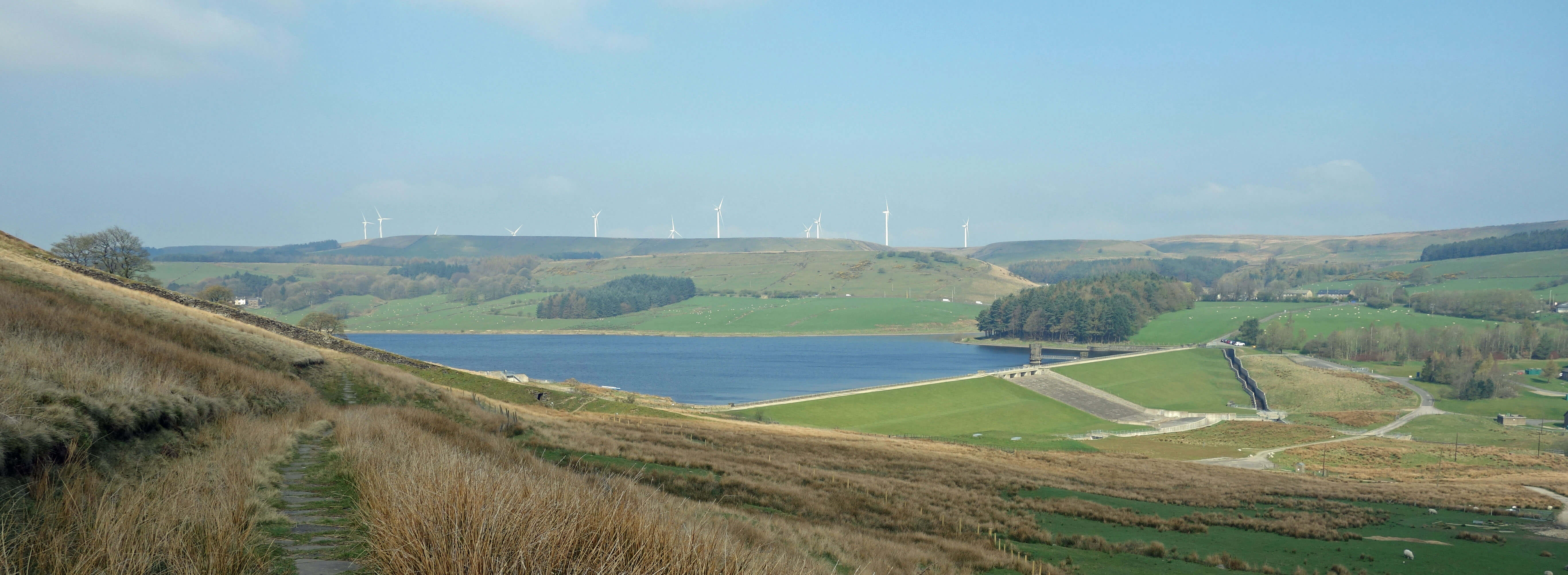
Calf Hey Reservoir
 >
>
Ogden Reservoir and Calf Hey Reservoir
As the Rossendale Way curved back I left it to walk up to the windmills that dominate
the head of the valley. The twelve turbines are not quite within Haslingden Grane but
lie over the watershed on Oswaldtwistle Moor, overlooking Oswaldtwistle and Accrington.
I detoured not to see the windmills but to have a look at Warmwithens Reservoir. This
too is no longer on the map. Where it was is now marked as ôResr (dis)ö. The reservoir
was built before 1849 (it is shown on a map of that date) but its dam collapsed in 1970,
a few years after it had been æimprovedÆ. Luckily, the escaping water was held in two
lower reservoirs, preventing serious damage below. Today, there is only an otherwise
enigmatic embankment, about a hundred metres long, with an overflow channel, to indicate that
the reservoir was ever there. I like to be reminded that our engineers are not
infallible and to see how quickly nature reclaims what should be its.
As for Haslingden Grane, it would be an exaggeration to say that nature has reclaimed
much of it. The evidence of our exploitation is plain to see, and my walk around the reservoirs
was accompanied by quarry rumbles, the noise of the B5232 traffic, and the swish of windmills.
Of the Haslingden Grane of 200 years ago, not much remains. We have submerged much of it,
planted trees and windmills on some of it, and quarried a lot of it. And yet arguably the
Grane has been improved for walkers like myself. Where once there were similar scattered
farmsteads trying to make a living on rough, boggy pasture and moorland, there are now
skilfully fashioned walking paths providing a variety of interest through what I originally
thought, judging from the map, to be unpromising terrain.
Date: April 8th 2019
Start: SD751232, Clough Head car park (Map: 287)
Route: NW on permissive path, E on Rossendale Way û Windy Harbour Farm û S, SE û
Holden Hall û S over dam, W above the three reservoirs û Haslingden Grane û NW, N (across B6232) û
Higher Warmwithens, Reservoir (disused) û S, E on
Rossendale Way, SE û car park
Distance: 8 miles; Ascent: 200 metres
Home
Preamble
Index
Areas
References
Me
® John Self, 2018-

Top photo: The western Howgills from Dillicar;
Bottom photo: Blencathra from Great Mell Fell