
Home
Preamble
Index
Areas
Dales
Hills
Lakes
Places
Reserves
Rivers
Structures
Villages
References
Me
Saunterings: Walking in North-West England
Saunterings is a set of reflections based upon walks around the counties of Cumbria, Lancashire and
North Yorkshire in North-West England
(as defined in the Preamble).
Here is a list of all Saunterings so far.
If you'd like to give a comment, correction or update (all are very welcome) or to
be notified by email when a new item is posted - please send an email to johnselfdrakkar@gmail.com.
100. Crookdale and Horseshoes
Horseshoes are said to bring good luck, so I thought IÆd try one. Hill-walkers are particularly fond of horseshoe walks, that is, walks out on one ridge of a dale, across the head of the dale, and back along the opposite ridge. There is something satisfying about a walk that fully embraces a dale, enabling it to be viewed from all angles. It is good to be able to see across the dale to where you will be walking later and, later, to see back across to where you were walking before.
 In his comprehensive review of Lakeland fells, Birkett (1994) includes 21 horseshoe walks among his 129 walks up 541 tops. He names his Horseshoes:
Ģ Bannerdale (7 miles over East Top, Bowscale Fell, Bannerdale Crags, Souther Fell)
Ģ Bannisdale (8 miles over Whiteside Pike, Todd Fell, Capplebarrow, Ancrow Brow, Long Crag, White Howe, Borrowdale Head, Lamb Pasture)
Ģ Buttermere (6 miles over Fleetwith Pike, Black Star, Grey Knotts, Brandreth, Haystacks)
Ģ Calder (8 miles over Blakeley Raise, Grike, Crag Fell, Whoap, Lank Rigg, Kinniside, Latter Barrow, Swarth Fell, Burn Edge)
Ģ Cawdale (9 miles over Low Kop, Red Crag, Wether Hill, Loadpot Hill)
Ģ Combe Gill (5 miles over Thornythwaite Fell, Combe Head, Stonethwaite Fell, Rosthwaite Cam, Bessyboot)
Ģ Crookdale (7 miles over High House Bank, Robin Hood, LordÆs Seat, Great Yarlside, Little Yarlside, What Shaw)
Ģ Dale Head (10 miles over Skelgill Bank, Catbells, Maiden Moor, High Spy, Dale Head, Hindscarth, High Crags, Red Knott, Scope End)
Ģ Deepdale (10 miles over Arnison Crag, Birks, Gavel Pike, St Sunday Crag, Cofa Pike, Fairfield, Hart Crag, Gill Crag, Gale Crag)
Ģ Fairfield (10 miles over Low Pike, High Pike, Dove Crag, Hart Crag, Fairfield, Great Rigg, Rydal Fell, Heron Pike, Nab Scar)
Ģ Hartsop (6 miles over Hartsop Dodd, Stony Cove Pike, Gray Crag)
Ģ Helm Crag to Steel Fell (7 miles over Helm Crag, Gibson Knott, Calf Crag, Dead Pike)
Ģ Hesk Fell (6 miles over The Pike, Hesk Fell, Yoadcastle, Stainton Pike, Whitfell, Bigert)
Ģ Hope Gill (6 miles over Dodd, Whiteside (East, West), Gasgale Crags, Hopegill Head, Sand Hill, Ladysike Pike, Swinside)
Ģ Kentmere (12 miles over Shipman Knotts, Goat Scar, Kentmere Pike, Harter Fell, Mardale Ill Bell, Thornthwaite Beacon, Froswick, Ill Bell, Yoke)
Ģ MartindaleÆs Bannerdale (9 miles over Beda Head, Angletarn Pike (North, South), Brock Crags, Rest Dodd, The Nab)
Ģ Mosedale (7 miles over Looking Stead, Pillar, Black Crag, Scoat Fell, Steeple, Red Pike)
Ģ Naddle (7 miles over Scalebarrow Knott, Harper Hills, PowleyÆs Hill, Hare Shaw, Naddle High Forest, Wallow Crag, Naddle Low Forest)
Ģ Riggindale (7 miles over Rough Crag, High Street, Rampsgill Head, Kidsty Pike)
Ģ Robinson (7 miles over Scope End, Red Knott, High Crags, Hindscarth, Robinson)
Ģ Wetherlam and the Greenburn (9 miles over Birk Fell, Wetherlam, Black Sails, Swirl How, Great Carrs, Little Carrs)
It is easily possible to add further horseshoes ¢ for example, Dovedale, Eskdale, Grisedale and Scandale are all fairly well-known horseshoes ¢ and, of course, horseshoes are not restricted to the Lake District.
I opted for the most remote and the least craggy of BirkettÆs 21 horseshoes, that is, the Crookdale Horseshoe. This is within
the Shap Fells, the wide area of moorland south of Shap and west of the A6.
I first walked under a double line of tall pylons marching across
the moor, next to a rough track that, hard to believe now, was the main thoroughfare before the A6 was built and where Bonnie Prince Charlie
marched his Jacobites. I forded Crookdale Beck and scrambled up the slopes of High House Bank (495 metres, which may seem an impressive
height ¢ but the car was parked at 426 metres, although to do myself justice I had dropped down a fair way to the beck). This scramble was
the only steep climb of the whole walk. Once the ridge was attained, it was a matter of striding out (as far as that was possible over
the boggy bits) over the various humps along the way. From this southern ridge of the horseshoe the view south into upper Borrowdale and across to
Bannisdale Fell was rather better than that into the featureless, grassy Crookdale.
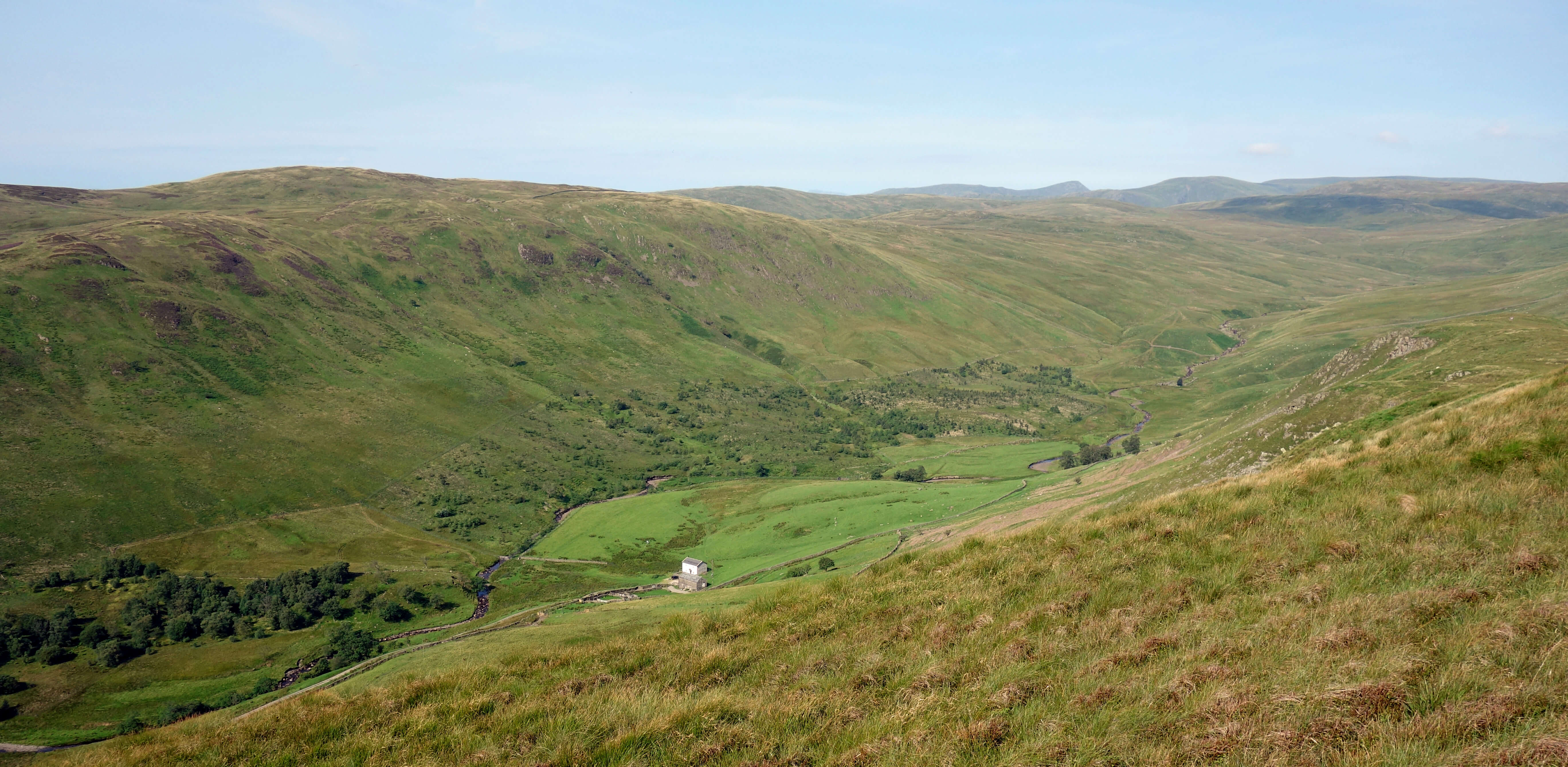
Upper Borrowdale from High House Bank (and is that Kidsty Pike?)
Middle Borrowdale from High House Bank
After an hour or so I reached LordÆs Seat (524 metres). It is clear from Lord's Seat, and from the map, that the top of Harrop Pike (637 metres),
over a mile ahead, marks the head of Crookdale. The headwaters of Crookdale Beck run directly from it. However, Birkett considers that ōrocky knolls and peat hag do not allow it to be easily reachedö from LordÆs Seat and instead directs the walker to traverse over Crookdale Beck and up to the northern ridge.
What sort of horseshoe is that? It omits the climax, the very apogee, the zenith of the real horseshoe, its highest point and grandest view.
Wainwright (1974) also describes what he calls "the Crookdale Horseshoe" but his
version is even worse. He directs walkers away from Harrop Pike and the whole
northern ridge! Instead, walkers are to forego the views from the ridge and trudge within the dreary, damp, enclosed dale, on the bank of Crookdale Beck. I expect that Wainwright had a good giggle at the thought of his devoted followers, without a mind of their own, dutifully traipsing into this morass. He did at least give fair warning, writing of the ōdrab monotony ģ of the marshy valley floor, of which in a lifetime one experience is enoughö. The reason that both Birkett and Wainwright do not describe a proper Crookdale Horseshoe is that their omitted tops are visited on others of their walks. Such considerations will not sully the purity of my horseshoe.
So, I set off for Harrop Pike. The bee-line for Harrop Pike, over the rocky knolls and peat hag that deterred Birkett, is not the way to
go. The true horseshoer must follow the watershed, although admittedly it isnÆt really a ridge here. This passes Red Crag to the west, and as
it happens a sort-of-path can be picked up beyond LordÆs Seat to take us past Red Crag and up to a fence which may then be followed
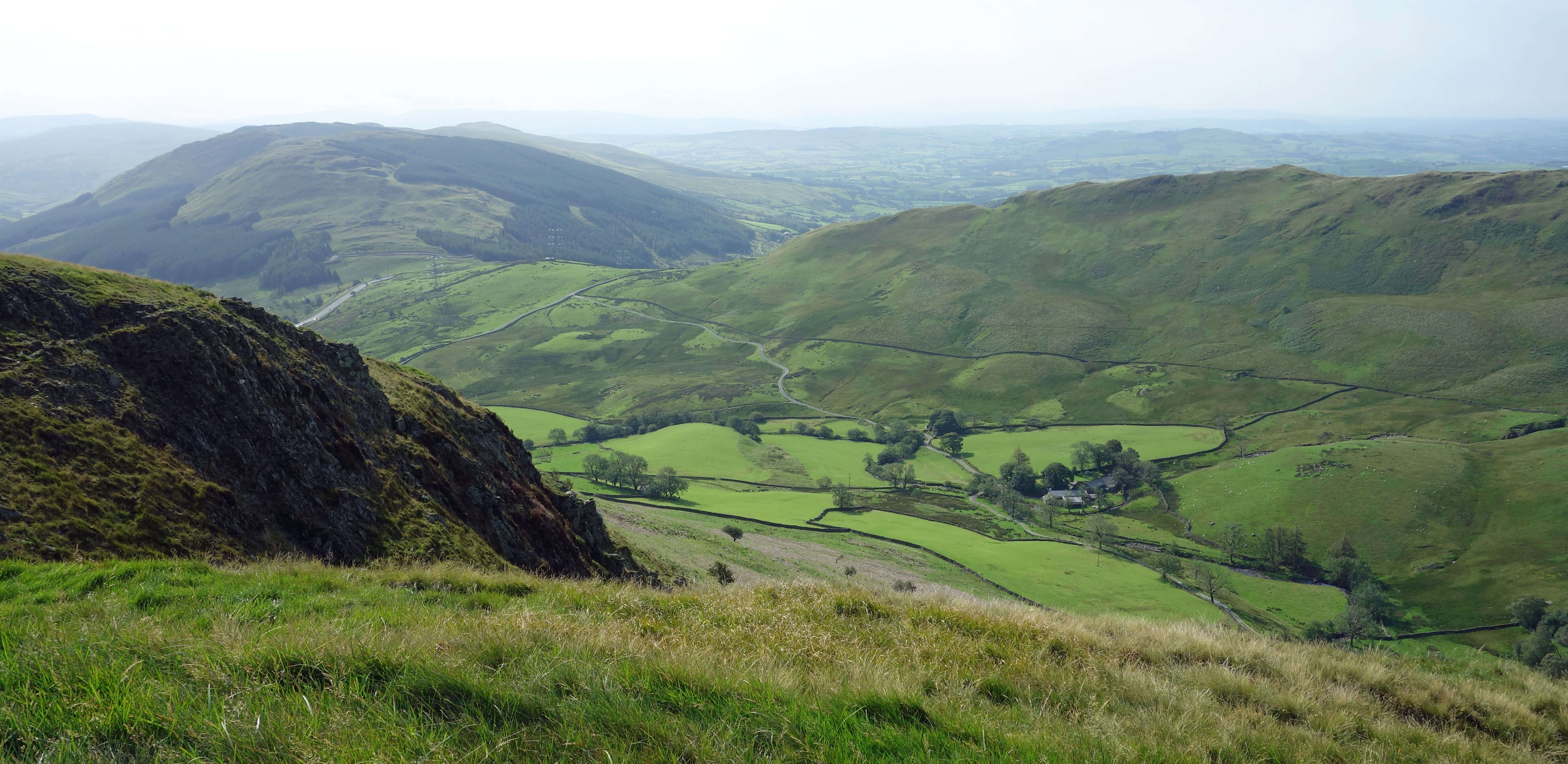
all the way to the top. This is straightforward and avoids the worst of the peat hag. Harrop Pike is not high enough to provide much of a view of the central Lake District fells ¢ in fact, there are only such tantalising glimpses of them along the whole southern ridge that itÆs hardly worth the trouble of trying to identify them. However, from Harrop Pike to the east there are excellent views of the expanses of the northern Shap Fells and in the distance of the Howgills and northern Pennines.
Harrop Pike (and is that The Old Man of Coniston?)
Nobody with the heart, soul and spirit of a fell-walker will have read the list of horseshoes above without mentally ticking off those already walked and maybe setting the target of walking some or all of the others. Fell-walkers canÆt help bagging items on a list,
so why not horseshoes? If, however, we are to invent such a thing as horseshoe-bagging then we need to be precise about our horseshoes. We have already seen that to qualify a horseshoe has to include the head of the dale and both ridges.
A systematic naming system would be welcome too. The identifying factor for a horseshoe is the dale or watercourse enclosed, not a peak that happens to be passed on the way. The Fairfield Horseshoe ¢ the most well-known and most walked horseshoe ¢ should really be called the Rydal Horseshoe because it is around Rydal Beck. It is perfectly possible to have another horseshoe that includes Fairfield and indeed there is one on BirkettÆs list ¢ the Deepdale Horseshoe. This has an equal right to be called the Fairfield Horseshoe, although that would, of course, be confusing.
Consider the Blencathra Horseshoe. That is hard to do as there is no agreed such thing. However, there are on its southern slopes four watercourses (Blease Gill, Gate Gill, Doddick Gill and Scaley Beck) and therefore five ridges. That would provide four horseshoes and, if you allow yourself to encompass two or more dales, a further six horseshoes. There would be no ambiguity if the horseshoes were named after the dale(s) or watercourse(s) enclosed. So if anyone would like to campaign for horseshoe-bagging then I would recommend that they begin by renaming the Fairfield Horseshoe. Good luck with that.
The return walk on the northern ridge has the virtues of simplicity (just follow the fences and walls) and of wide-ranging views ahead. But it is long. At first, the northern ridge provided no view into Crookdale, but I had seen more than enough of it already. Instead, there were views north of the empty fells of Mosedale, Sleddale and Wasdale, where in the past I have seen red deer, but not today. Eventually, Crookdale came back into view, with the ridge of High House Bank to LordÆs Seat beyond. The wall and fence led unerringly and uneventfully
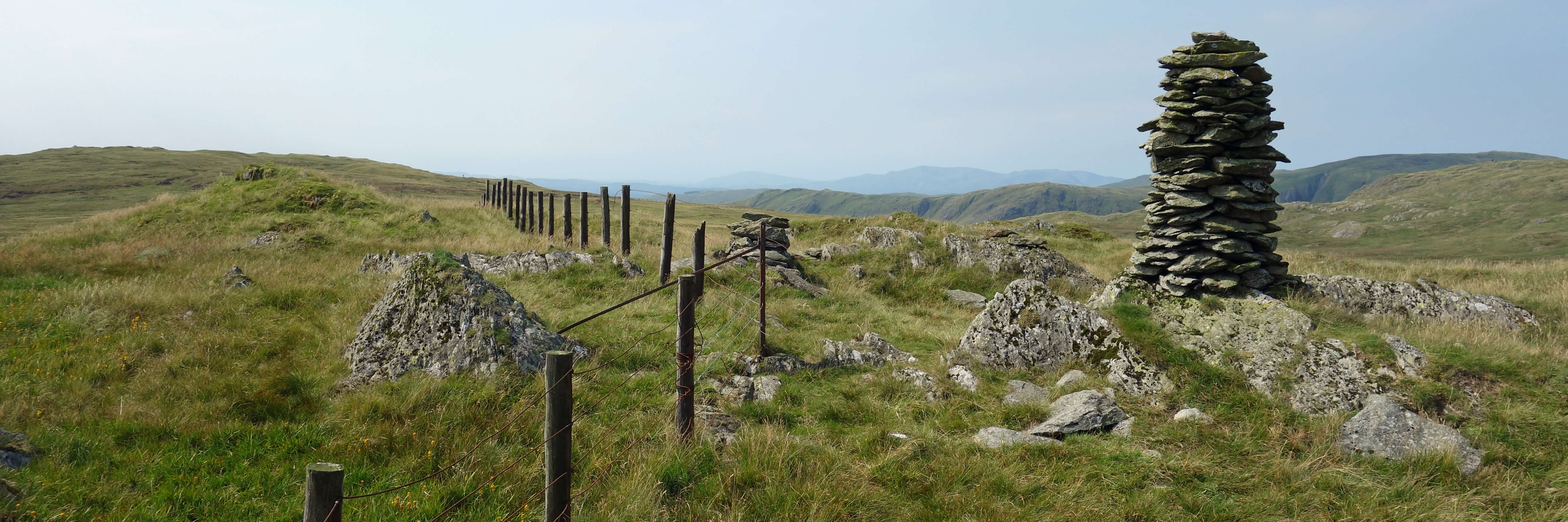
over Great Yarlside (585 metres), Little Yarlside and Whatshaw Common to reach the A6.
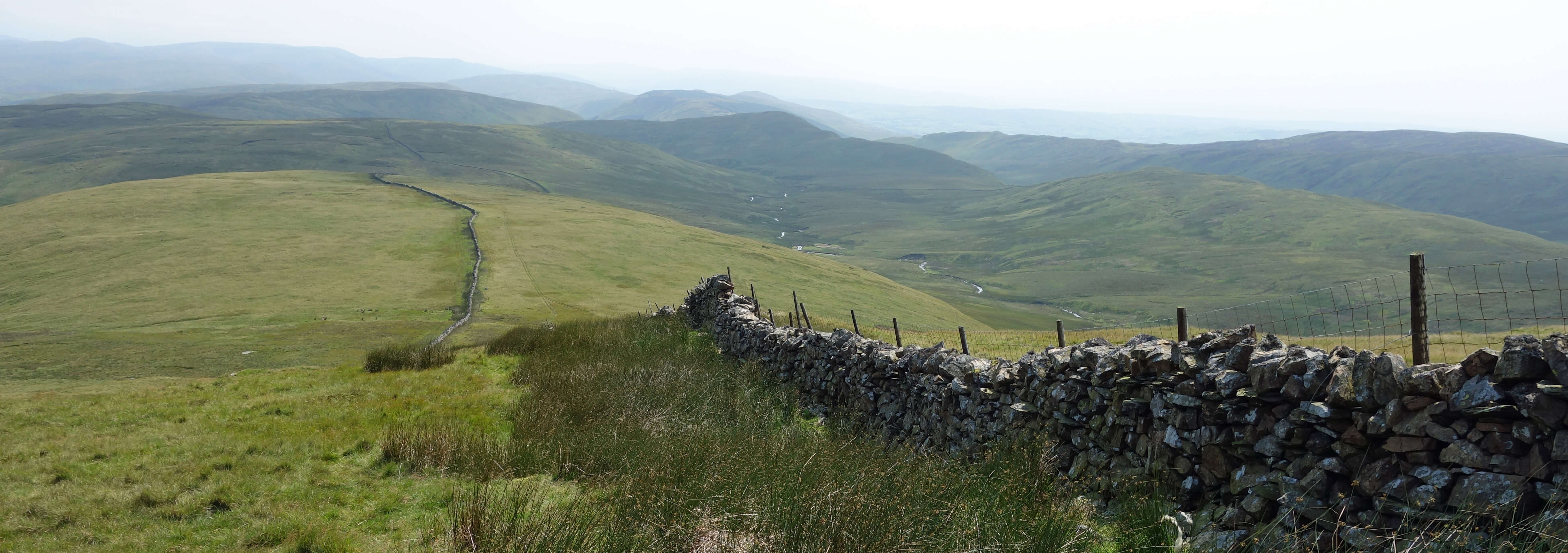
Crookdale (to the right) from Great Yarlside
Overall, then, the Crookdale Horseshoe (as properly walked) is a long, lonely, unexciting walk with expansive
views. There is little of interest to cause any pause, which is good because a steady tramp is whatÆs required.
Bavin (1999) writes that ōthe Shap Fells of eastern Lakeland extend over a desolate, inhospitable area of forty
square miles, crossed only by an old packhorse trail. This lofty, silent, barren moorland is uninviting,
uninhabited and unfrequented, except by creatures of the wildö. Which includes me.
Date: August 9th 2020
Start: NY554062, P on A6 (Map: OL7)
Route: W, SW (fording Crookdale Beck) ¢ High House Bank ¢ NW ¢ Robin Hood, LordÆs Seat ¢ W above
Red Crag ¢ fence ¢ N ¢ Harrop Pike ¢ E ¢ Great Yarlside ¢ SE ¢ Little Yarlside ¢ SE, E ¢ P on A6
Distance: 9 miles; Ascent: 560 metres
Home
Preamble
Index
Areas
Dales
Hills
Lakes
Places
Reserves
Rivers
Structures
Villages
References
Me
® John Self, 2018-

Top photo: The western Howgills from Dillicar;
Bottom photo: Blencathra from Great Mell Fell