
Home
Preamble
Index
Areas
References
Me
Saunterings: Walking in North-West England
Saunterings is a set of reflections based upon walks around the counties of Cumbria, Lancashire and
North Yorkshire in North-West England
(as defined in the Preamble).
Here is a list of all Saunterings so far.
If you'd like to give a comment, correction or update (all are very welcome) or to
be notified by email when a new item is posted - please send an email to johnselfdrakkar@gmail.com.
173. Early Spring in Chapel-le-Dale
We have frogspawn in our pond. That might seem nothing to write here about but we are elated.
We always used to have frogspawn but about fifteen years ago it stopped appearing. I attributed
this to my foolishly putting some inherited fertiliser, so out-of-date it had turned black,
on the lawn, and it had then washed into the pond, to the frogsí
displeasure. Perhaps the frogs croaked.
Thatís by-the-by except that it shows that spring is on the way. I set out hoping to
see more signs of spring during a relaxed stroll in the February sunshine from Ingleton to
Chapel-le-Dale and back, without serious issues (like Environmental Land Management) or
strenuous objectives (like the top of Ingleborough) on my mind. As I walked up Oddies Lane I
heard a woodpecker drumming noisily nearby ñ itself a sign of spring ñ but I couldnít locate it.
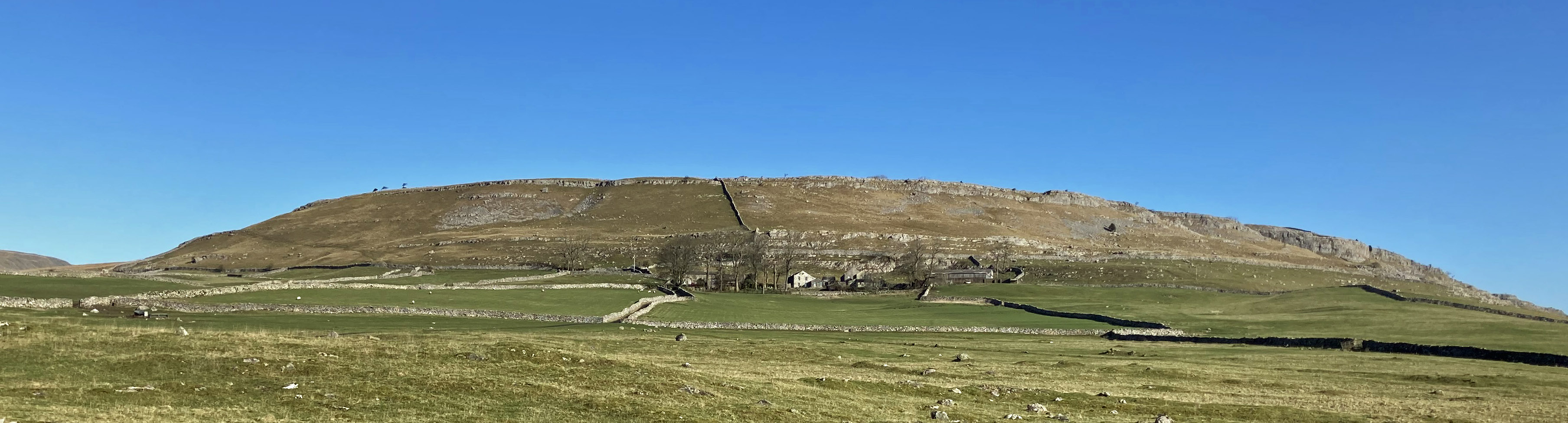
Twisleton Scar End from Oddies Lane
Oddies Lane gradually opened out to provide views of Twisleton Scars ahead and of Ingleborough,
with a frosty top, to the right. After a couple of miles the lane acquired an apostrophe, to
become Oddieís Lane ñ at least, according to the OS map. Is one or other name a slip? The OS,
much as we admire it, does make mistakes. The Appleby Road that I crossed on my previous outing
is labelled B6259 at one end and B6295 at the other.
Here the OS has attached the name ëRiver Doeí to the wrong watercourse, the one to my right.
I donít want to get into this again ñ it was adequately discussed as long ago as 1892 by Harry Speight
(Speight, 1892,
pages 224-226). He wrote that ìthe confusion with respect to the Doe arises mainly from this name
having been erroneously applied by previous Ordnance surveyors to the Chapel or Dale Beckî.
The River Doe was in fact the beck to the west (Kingsdale Beck). Since then the OS has persisted and everyone
now calls the eastern stream the Doe, except me. I call it Chapel Beck. It is too small to demand to
be a River anyway.
Here Oddieís Lane is on the line of the Roman road between the fort at Bainbridge and, um,
somewhere south (I am sure that the Romans knew where). It is always good to stride
out accompanied by centurions. For three miles I had the limestone cliffs of Twisleton Scars to
my left. In the fields immediately to my left were occasional outcrops of a different
kind of rock, a grey lichen-covered slate. I remember once sitting in the White Scar Caves cafÈ after a
period of heavy rain when these scars and fields seemed like an inside-out bath-tub in which
someone had punctured a line of holes half-way up the side. Water that
was outside the tub, having percolated through the limestone,
was streaming into the tub from a series of resurgences as the water met the layer of impermeable slate.
There were no resurgences today. The fields were full of sheep ñ but no lambs. I had
seen lambs in the lowland meadows on the way here but it is 200 metres or so higher here and the
lambs are therefore later. I reached the hamlet of Chapel-le-Dale. How did it get to have this
name? According to Speight (1892), old maps called it Wisedale. Who put the ñleñ there? It
seems an un-Dalesian affectation. The name is nowadays applied also to the dale itself, which
used to be called Gretadale, but it canít be now because the OS has decreed that the River Greta
doesnít begin until what it calls the River Doe reaches Ingleton. At least the OS doesn't call the dale
Doedale (yet).
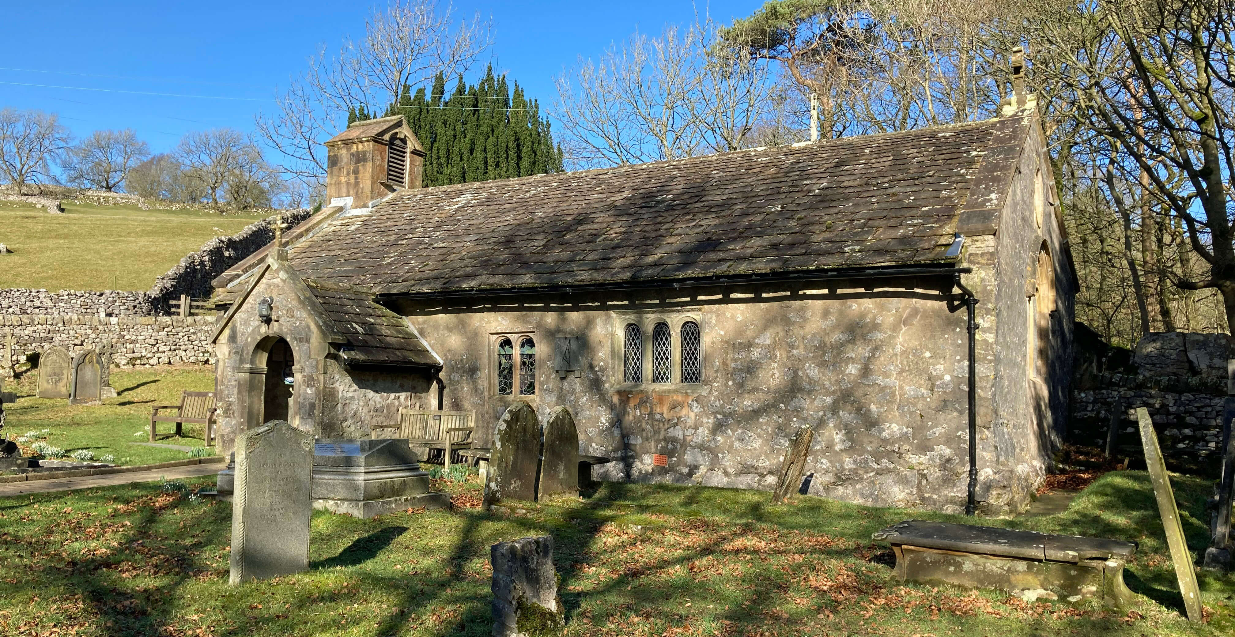
Left: Twisleton Scar from Oddie's Lane; Right: The chapel in Chapel-le-Dale.
I had a look at the chapel, as you must in Chapel-le-Dale. Built in the 17th century,
St Leonard's Church is in a modest, peaceful
setting ñ although the last time I came here there was a notice in the porch saying "Churchyard Rules
prohibit the depositing or burial of human remains without prior permission."
I found the stone (an old gatepost) dedicated to the ìmemory of the many men, women
and childrenî who died during the building of the Ribblehead Viaduct.
Could our memory extend to who they were? Were their lives so dispensable
that we havenít bothered to record their names? It would
take a much bigger memorial to list over 200 names. We have, I suppose, made some progress:
imagine if over 200 people died during the construction of a part of HS2.
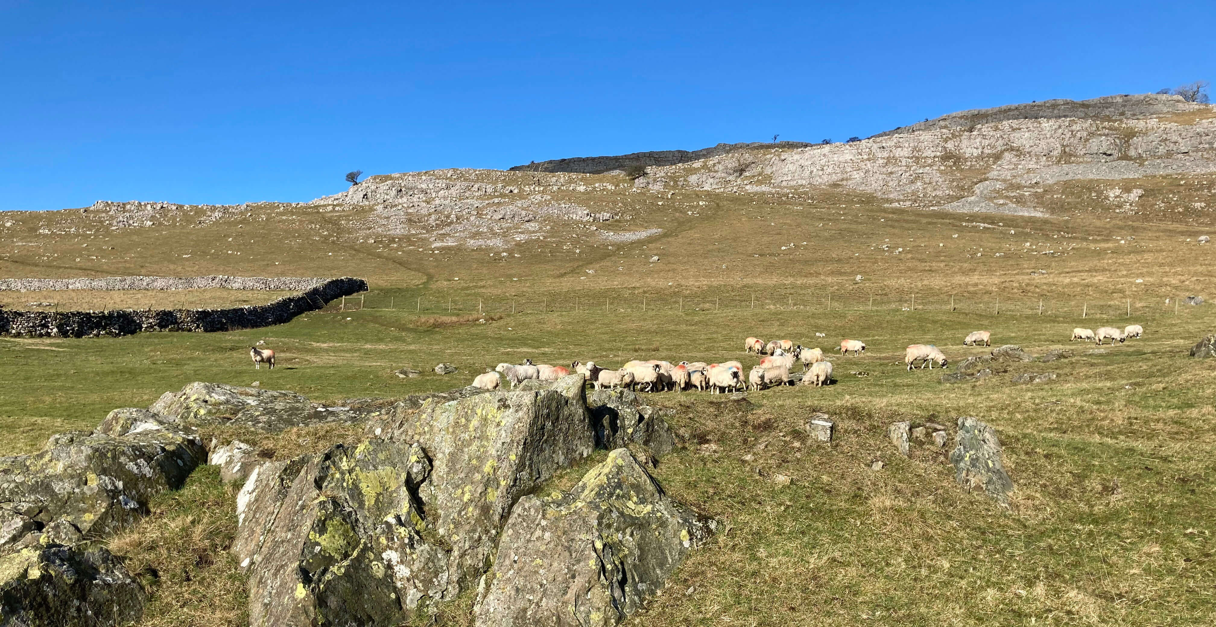
Crossing over from Chapel-le-Dale to the other side of the valley, I entered the
Southerscales Nature Reserve, managed by the Yorkshire Wildlife Trust.
Here the previously sheep-grazed slopes are being gradually
restored to a more natural state. I passed a number of newly-planted trees, with signs keen to tell
me that they had non-plastic, degradable protection, and a few of the native cattle (Belted
Galloways) that have been returned to the area.
Belted Galloways and Whernside from Southerscales Nature Reserve
I came to the enormous shakehole (60 metres diameter) called Braithwaite Wife Hole, a name that has provoked
various scurrilous suggestions concerning a Mr Braithwaite and/or his wife. These are
nonsense, of course, because it was called Barefoot Wives Hole before somebody misunderstood
the local dialect. But that name hardly solves the puzzle.
We need some scurrilous suggestions about barefoot wives.
Rural names add a great deal, without us really thinking about it, to our appreciation
of the countryside. Rural names, often based on particular features or people or events,
have evolved over centuries (unlike most urban names, which are invented to meet an
immediate need, to name a new estate, say). We can see how the process works in our own
lives. When we moved to our present home we walked up an unnamed lane that soon became
Blackberry Lane to us. And only us. But if the local community adopted it then it would become
the name which, if a mapmaker asked us, weíd tell them. It is not an inspired name but
we do have Great Knoutberry Hill, Crowberry Hill and Bleaberry Fell on our maps.
Rural names are liable to change,
as reasons for the namings change. Or at least they were.
Now, rightly or wrongly, they are fixed on OS maps.
Rural names are evocative even if weíre not sure what of. For example, I walked
next to Harry Hallamís Moss. Nobody knows who Harry Hallam was but if he existed then I
congratulate him for achieving
immortality on OS maps and thank him for providing a more interesting name than, say, Grey Moss.
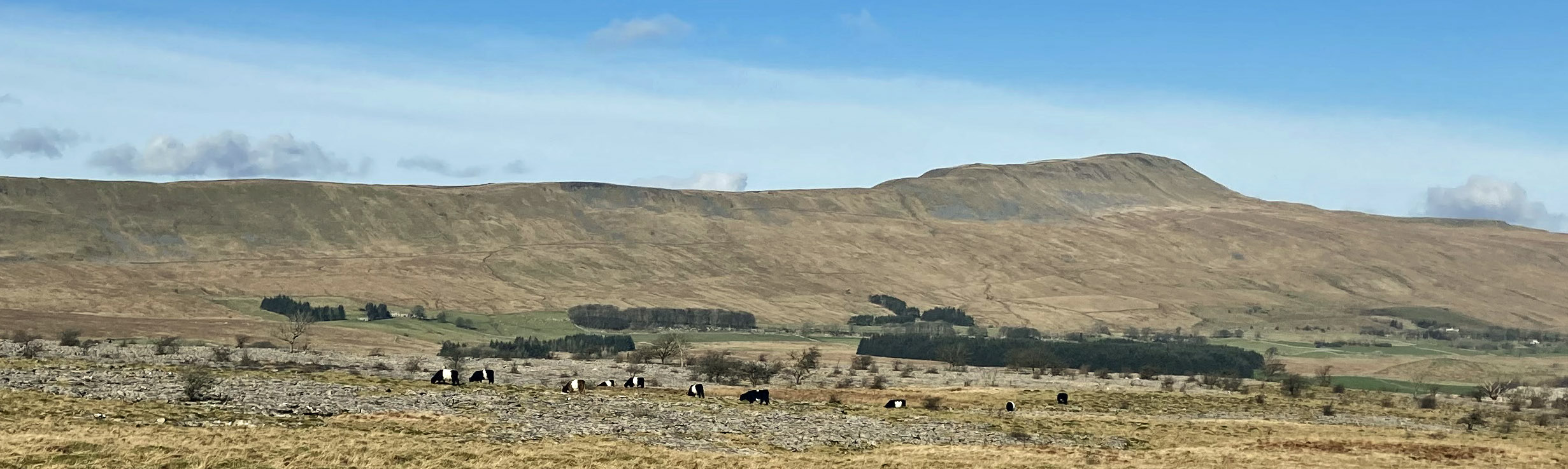
I now had a long walk back over the plateau that lies below Ingleboroughís western slopes and above
Raven Scar, the cliffs above the Chapel-le-Dale road. Thereís a Tatham Wife Hole here but I
didnít seek it out. I found a good path, created by cyclists it seemed, that weaved between the
bogs and limestone terraces that otherwise make walking here difficult.
Somewhere along the way the path must be above the vast voids of the White
Scar Caves.
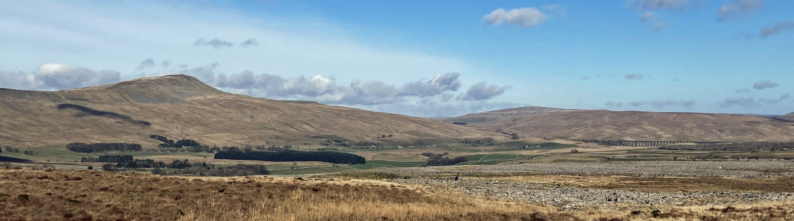
Whernside and the Ribblehead Viaduct from Harry Hallam's Moss
It was silent and lonely here, away from boisterous fell-walkers conquering Ingleborough and out of the
sight and sound of the Chapel-le-Dale road. Silent, that is, apart from two or three skylarks.
Skylarks migrate to the coast in winter but these were back already at 400 metres or so to
claim their spring nesting sites.
As I walked along, Ingleborough evolved from an ominously black, shaded mountain to a
sunlit upland.
I was entertained by some paragliders who seemed to be able to stay aloft
above Ingleborough all the time that I walked the miles below it.
This peculiar species hibernates through the winter months of gales, fogs and blizzards,
only emerging at the first calm, sunny day. Then it begins an instinctive toil up a
high mountain where, along with others of its species, it undergoes a remarkable transformation
akin to that of the dragonfly. It then bursts forth from the mountain to begin an
airborne existence. Unlike the dragonfly, the paraglider then, before sunset,
de-metamorphoses to resume its mundane, earth-bound life ñ only to begin the
whole process again at the next calm, sunny day.
Yes, it was beginning to feel like spring.
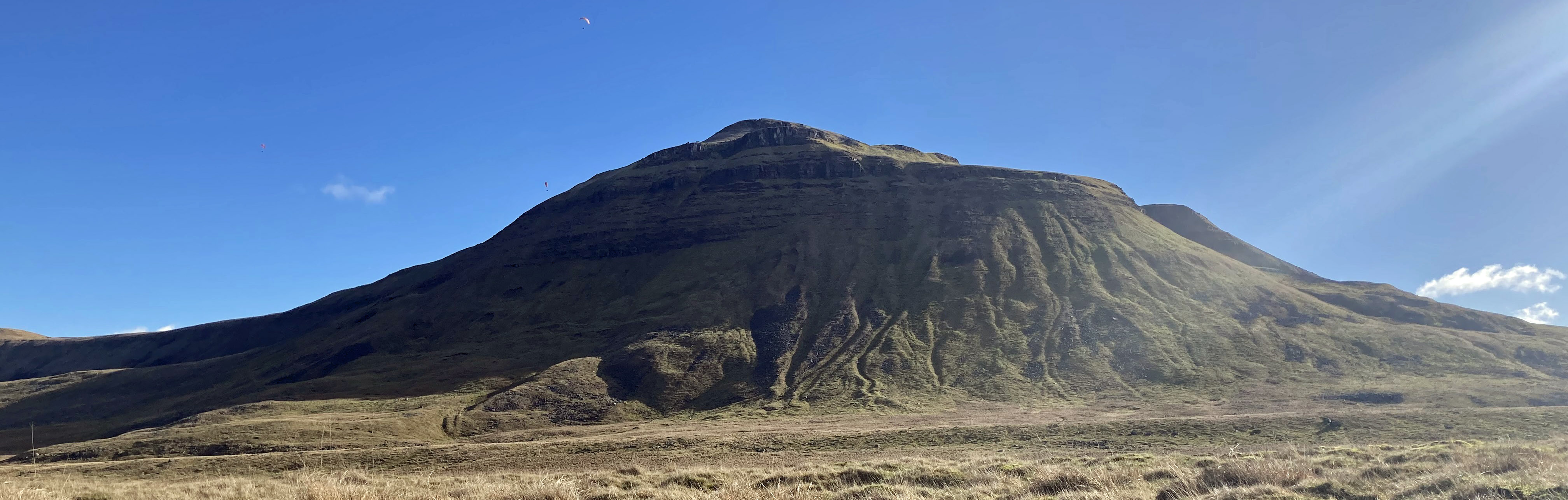
Ingleborough and paragliders (there are two, one just above the skyline - later
there were five in the air)
Date: February 23rd 2023
Start: SD694730, Ingleton Information Centre (Map: OL2)
Route: N, over bridge, N on Oddies Lane, NW ñ Chapel-le-Dale ñ E ñ Souther
Scales ñ S, SW ñ White Scars ñ SE ñ Fell Lane track ñ W ñ Ingleton
Distance: 11 miles; Ascent: 260 metres
Home
Preamble
Index
Areas
References
Me
© John Self, 2018-

Top photo: The western Howgills from Dillicar;
Bottom photo: Blencathra from Great Mell Fell