
Home
Preamble
Index
Areas
Dales
Hills
Lakes
Places
Reserves
Rivers
Structures
Villages
References
Me
Saunterings: Walking in North-West England
Saunterings is a set of reflections based upon walks around the counties of Cumbria, Lancashire and
North Yorkshire in North-West England
(as defined in the Preamble).
Here is a list of all Saunterings so far.
If you'd like to give a comment, correction or update (all are very welcome) or to
be notified by email when a new item is posted - please send an email to johnselfdrakkar@gmail.com.
111. From Millstone Grit to Limestone
 A geologist will find the ‘solid geology map’ (1:625,000 scale) of my local district rather dull. The bedrock is
millstone grit throughout. It is overlain here and there by glacial and alluvial deposits but even so the region
lacks the variety of, say, the Lake District. The 1:50,000 scale map of the Lancaster region, however, shows an
amazing range of detail, totally unsuspected by an amateur such as myself.
A geologist will find the ‘solid geology map’ (1:625,000 scale) of my local district rather dull. The bedrock is
millstone grit throughout. It is overlain here and there by glacial and alluvial deposits but even so the region
lacks the variety of, say, the Lake District. The 1:50,000 scale map of the Lancaster region, however, shows an
amazing range of detail, totally unsuspected by an amateur such as myself.
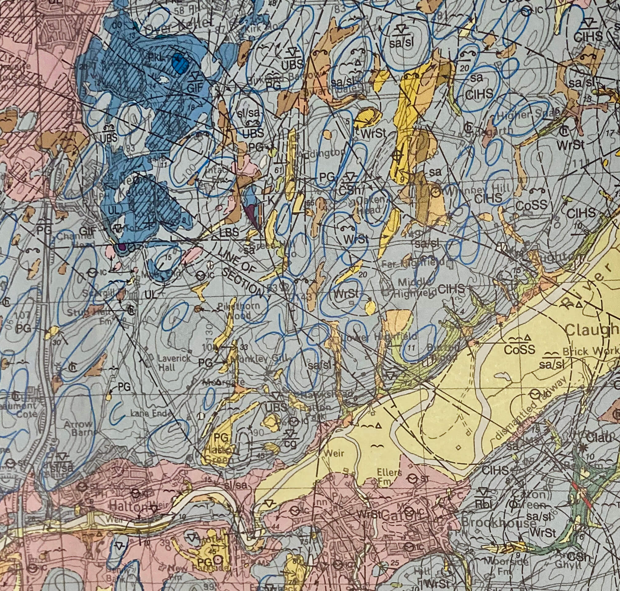
Right: Part of the British Geological Survey 1:50,000 scale map
for the scope of this walk. The M6 runs up the left, the Crook o'Lune is middle bottom,
with the Lune floodplain shown in yellow. (Copyright: British Geological Survey)
A section close to where I live shows
faults, anticlines, synclines, many varieties within the millstone grit group, and even intrusive igneous rocks
within a kilometre of my house. This detail, however, I must leave for another day, until I have a better
understanding of it. For now, I am stuck with millstone grit.
Or am I? The map also shows that just a few miles north the bedrock is limestone. Ah, limestone. The
bright crags and dry paths. I haven’t sauntered on limestone since Beetham on October 7th
[105]. I
miss it, but not as much as so much else at this time. Still, it provides motivation for a walk: to stride north to see where the limestone begins.
I set off through Halton, a village that with commendable self-sacrifice is single-handedly tackling the
local housing shortage. A large V of geese flew over. The sun rose over a distant Clougha Pike, reminding me of
my struggle against it on the previous outing. It would have been quiet but for the continuous rumble of the M6.
Our present restrictions are clearly not as strict – or not as strictly followed – as they were in the spring,
when there was an eerie silence. As I walked along I looked out for limestone in the fields and in the stone
walls, but I saw none. I could, however, see limestone far ahead, at Warton Crag.
I passed the intriguingly-named Coolbawn and the even more intriguingly-named Moor End Farm. The farm is not today at the end of any moor but perhaps it used to be. Millstone grit tends to accumulate peat and puddles, and hence tends to form a moor if uncultivated. Limestone doesn’t. Water drains through it and we don’t tend to refer to areas on limestone as moors. The thought that this farm once marked a transition point between millstone grit and limestone was perhaps confirmed by the white rocky outcrop in the field ahead.
After negotiating the narrow Shaw Lane, I turned to Hill Top, where I could at last touch limestone. And
then I reached undeniable evidence that this hill is of limestone – or rather was, since it has mainly disappeared.
I reached the rim of the huge chasm left by the Dunald Mill Quarry. The shrubs on the rim made it difficult to see
into the chasm but it appeared to be entirely abandoned and now to host a large lake. The equally huge chasm across the
road seemed, however, to be occupied by industrial units.
This
video
provides an aerial view of the two quarries. The video describes the eastern quarry as a 'working quarry' but
I don't think it is working as a quarry. The road nearby has none of the whiteness it used to have.
According to a 2010 report, the quarries are supposed to be completely restored by 2023, the western quarry “to a lake with
visitor viewing facilities” and the eastern one “to an
area of wildlife meadows”. From what I could see,
they need to get a move on.
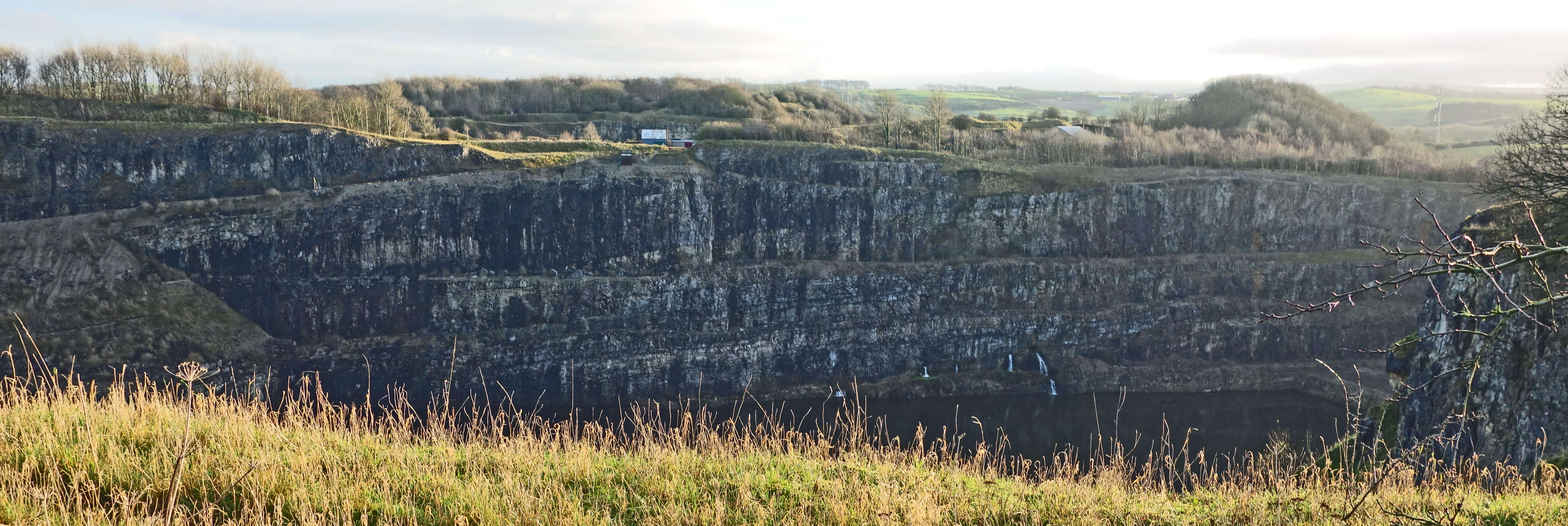
Dunald Mill Quarry
It should not be a surprise to find a quarry here. Quarries often develop on the fringes of a geological area. If people to the south, say, in the Lune valley want limestone, as they did, then they will seek it from the nearest limestone hill, which is here near Nether Kellet. Once quarrying has started, it will continue, to create these craters, as long as demand continues, as it did until a decade or two ago.
To the south of the quarry is Dunald Mill Hole, a cavern that was once something of a tourist attraction,
even stimulating a
poem
by Letitia Elizabeth Landon (1802-1838), although I hadn't heard of her, so perhaps that's not
saying much. Further along the lane, surprisingly, are the substantial
facilities of the Carnforth Compressor Station. Whatever a compressor station is, it is good that they have
hidden it away from all but the occasional intrepid walker. To the left, of more interest to me, was a large limestone outcrop. I was tempted to trespass to walk upon it – but I mustn’t. The time will come again, eventually, when I will be able to walk on real limestone, in, say, the Yorkshire Dales.
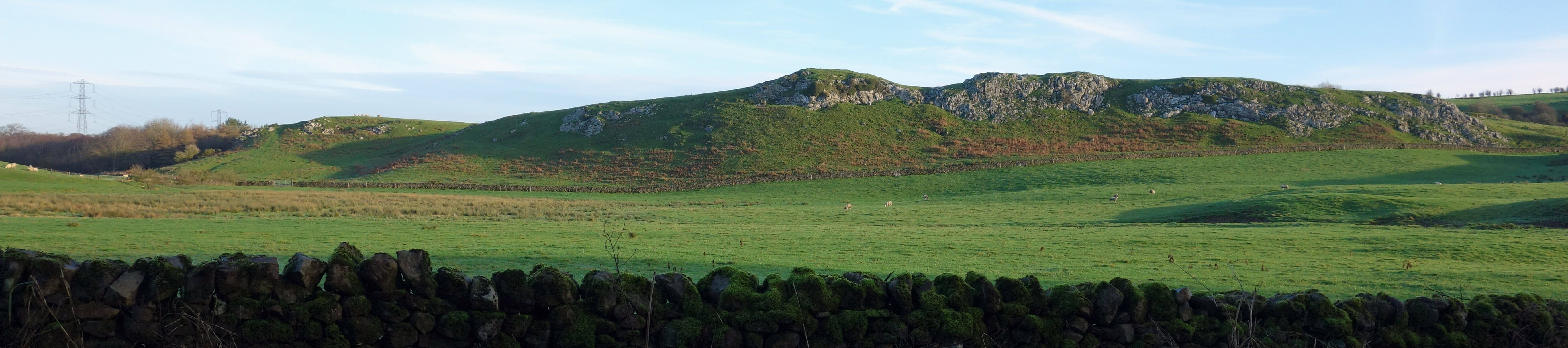
The limestone outcrop
As I expected, this proved to be the last I saw of limestone. I walked down, past Halton Park, to my
home valley, where, in the absence of wind, the windmills were stationary, a smoky haze had settled, and a
murky mist obscured views of Ingleborough. Ahead were the dark, millstone grit hills of Ward’s Stone,
Grit Fell and Clougha Pike.
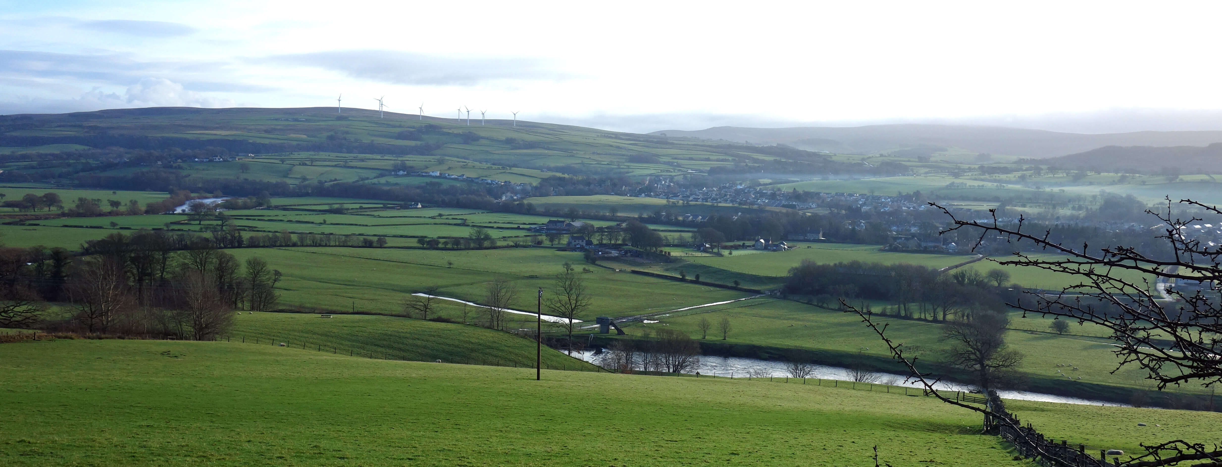
River Lune and Caton Moor from Halton Park
Date: December 22nd 2020
Start: SD506643, A683 lay-by at Denny Bank (Map: OL41)
Route: (linear) N over bridge – Halton – NW, along Scargill Road – N, along Shaw Lane – E, N, E – Long Dales Lane – S, SE on Dunald Mill Lane – S past Halton Park, SW, S – Lune – E – Brookhouse
Distance: 8 miles; Ascent: 125 metres
Home
Preamble
Index
Areas
Dales
Hills
Lakes
Places
Reserves
Rivers
Structures
Villages
References
Me
© John Self, 2018-

Top photo: The western Howgills from Dillicar;
Bottom photo: Blencathra from Great Mell Fell