The Land of the Lune
The Land of the Lune presents
a guide to the region of northwest England that lies within the Lune watershed.
It covers parts of the Howgills, the Lakes, the Dales and the Forest of
Bowland, and the area between. It travels along the Lune and its tributaries
(including the Rawthey, Clough, Dee, Greta, Wenning, Conder and Cocker),
visiting places of interest along the way, such as Tebay, Sedbergh, Kirkby
Lonsdale, Ingleton, Bentham and Lancaster.
The First Edition (2008) of The
Land of the Lune is now out of print.
A pdf version of the Second Edition (2010) was placed on-line but
it was not suitable for small screens, and has therefore been replaced
by this html version. This has the same text and photographs as the 2010 pdf version,
but is formatted differently and has a few necessary updates.
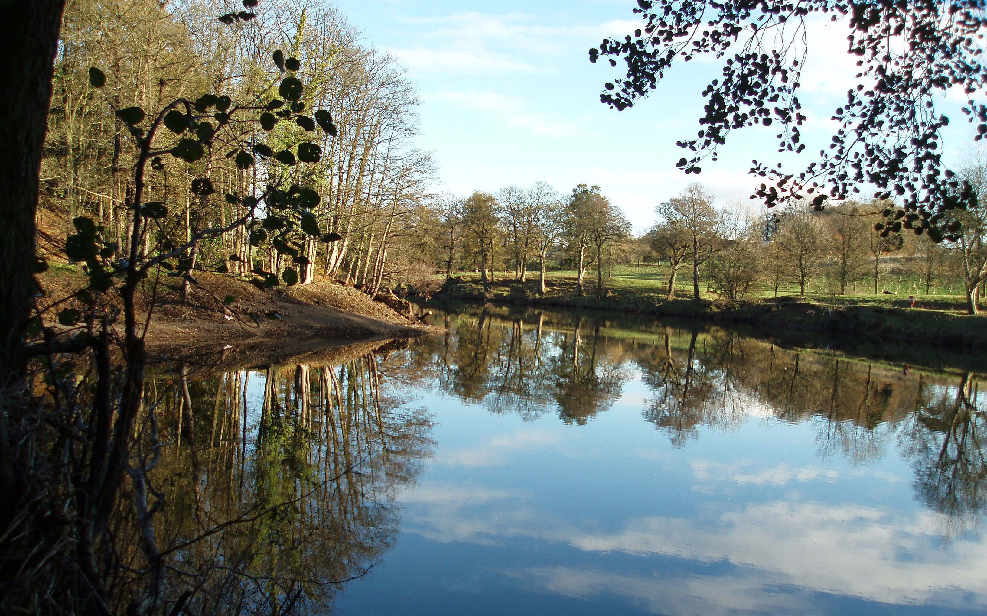
The Lune at the Crook oĺLune
Contents
1. Northern Howgills and Orton Fells
2. Shap Fells and Birkbeck Fells
3. Western Howgills and Firbank Fell
4. Upper Rawtheydale
5. Lower Rawtheydale and Dentdale
6. Middleton Fell
7. Middle Lunesdale and Leck Fell
8. The Greta Headwaters
9. Gretadale and a little more Lunesdale
10. The Wenning Headwaters
11. Wenningdale, Hindburndale and Roeburndale
12. The Lune Floodplain and the Top of Bowland
13. The Lune to Lancaster
14. The Salt Marshes
15. Into Morecambe Bay
References
Introduction
The view from the Crook oĺLune at Caton is
tranquil. The River Lune, nestled deep within its
banks, meanders toward us from the hazy hills in
the distance. But on a few days each year the scene is
very different. The Lune then is a muddy torrent, raging
halfway up Penny Bridge and stretching wide across the
floodplain. An obvious question on such a day is: where
does all this water come from?
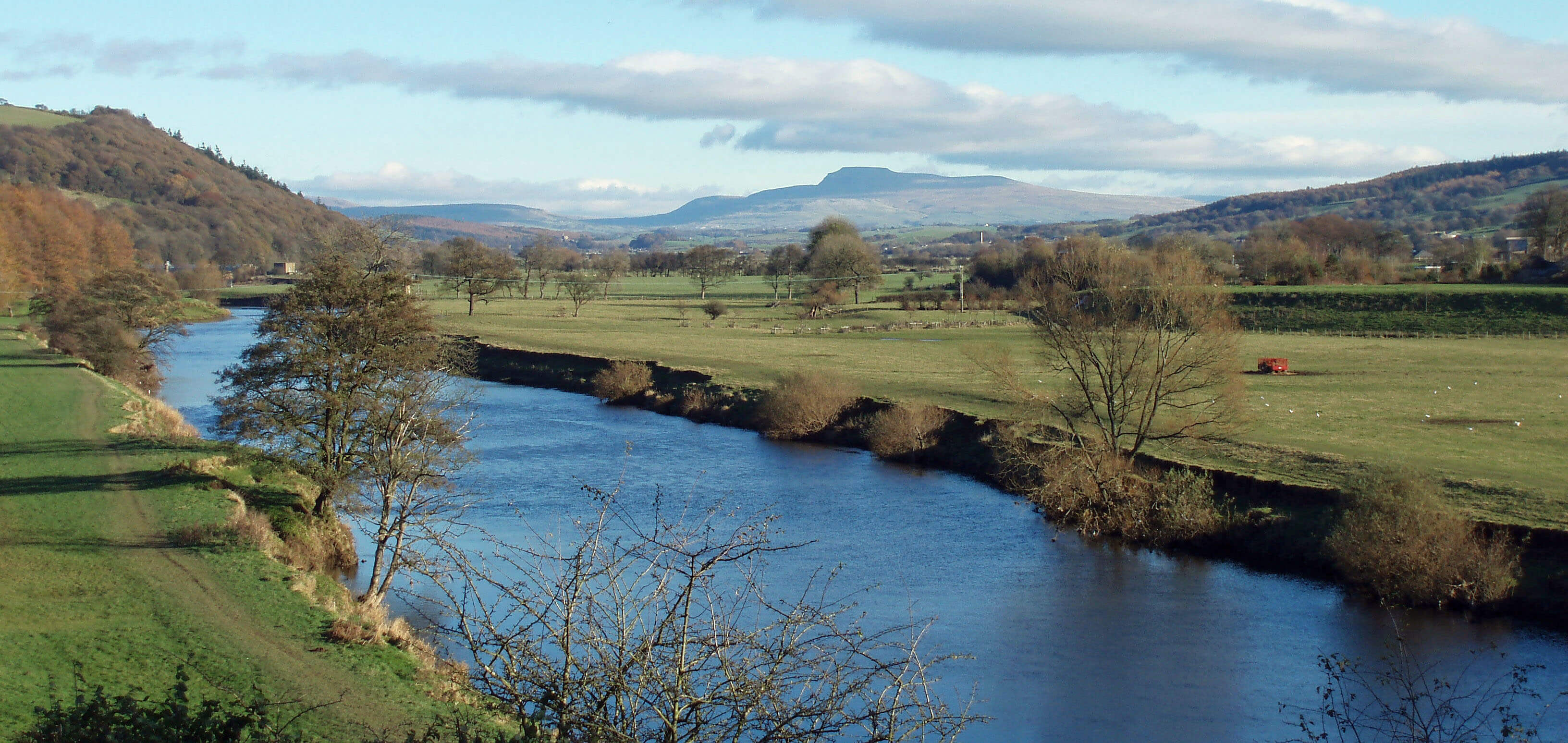
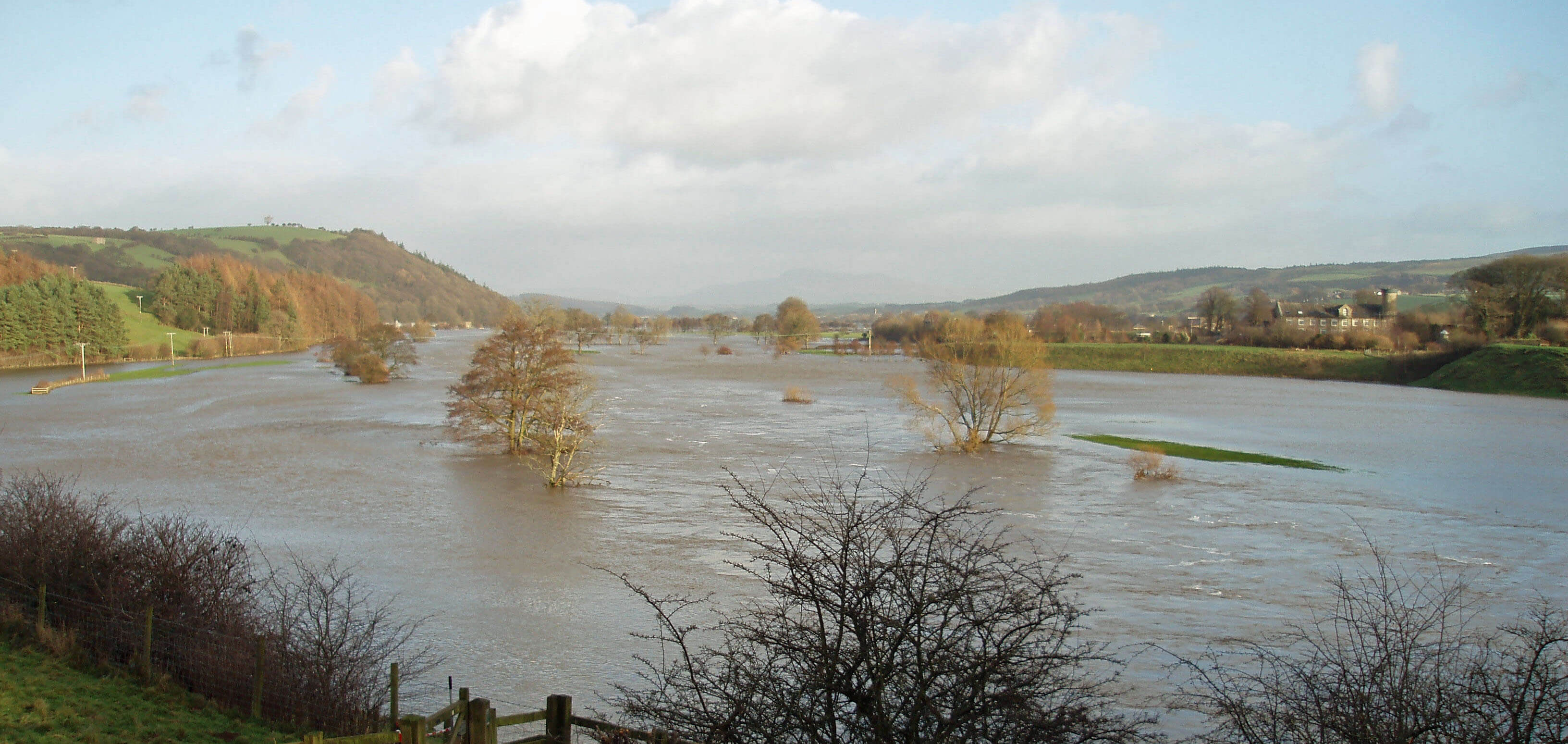
Two views from the Crook oĺLune
This book answers this question as a pretext for
providing a guide to a part of northwest England that is
generally overlooked. As we will see, the region within
the Lune watershed includes parts of the Lake District,
the Yorkshire Dales, the Forest of Bowland and the
Howgills, and all of what lies between them. Our region,
however, gets little attention. For example, the National
Trust, whose mission is to preserve ôplaces of historic
interest or natural beautyö, owns about 350 sq km in
the Lake District and 60 sq km in the Yorkshire Dales
but within the Lune watershed only one public house,
and that it did not actively acquire but gained through
a bequest.
Perhaps this is understandable because the region
within the Lune watershed has none of Englandĺs greatest
buildings, no major historic events happened here, none
of Englandĺs greatest men or women were born or lived
here, and there are no sites of international ecological
importance. Even so, if we approach the region without
great expectations, we will find a great deal of interest
and appeal ľ not on the majestic scale of the best of the
Lake District but certainly not deserving of complete
neglect. There have been thousands of books written on
the Lakes but hardly a handful on the Lune region.
The reputation of the region suffers from it being
hurried through by people on their way to the Lakes
and the Dales. It has long been regarded as a kind of
consolation for those unable to reach their intended
destination. For example, The Pictorial History of the
County of Lancaster, published in 1854, said ôThe vale
of the Lune may now be visited from London in a day,
thanks to railroads; and if the stranger go not as far as
Furness or Westmoreland, he may still say he has entered
the portal of the northern scenery of England, and found
that alone has repaid his visit, especially if he prefer the
tranquil in nature to the severe and grand ľ to pore over
the bubbling brook, rather than listen to the thunders of
the cataractö.
We will follow the waters of the Lune and all its
tributaries as they make their way from the fells to the
estuary. This will take us through a variety of landscapes
ľ fells, moors, crags, valleys, pastures, floodplains and
estuary ľ but all the while, in our mindĺs ear, we will be
accompanied by the comforting sounds of the beck and
river. The Lune itself is not a long river, a mere 105km,
but it drains 1285 sq km of varied terrain that fortunately
remains in a condition relatively unaffected by so-called
development. The Lune valley is a fine one but much
more of interest is added if we widen our scope to
include its tributaries.
A Word on Terminology
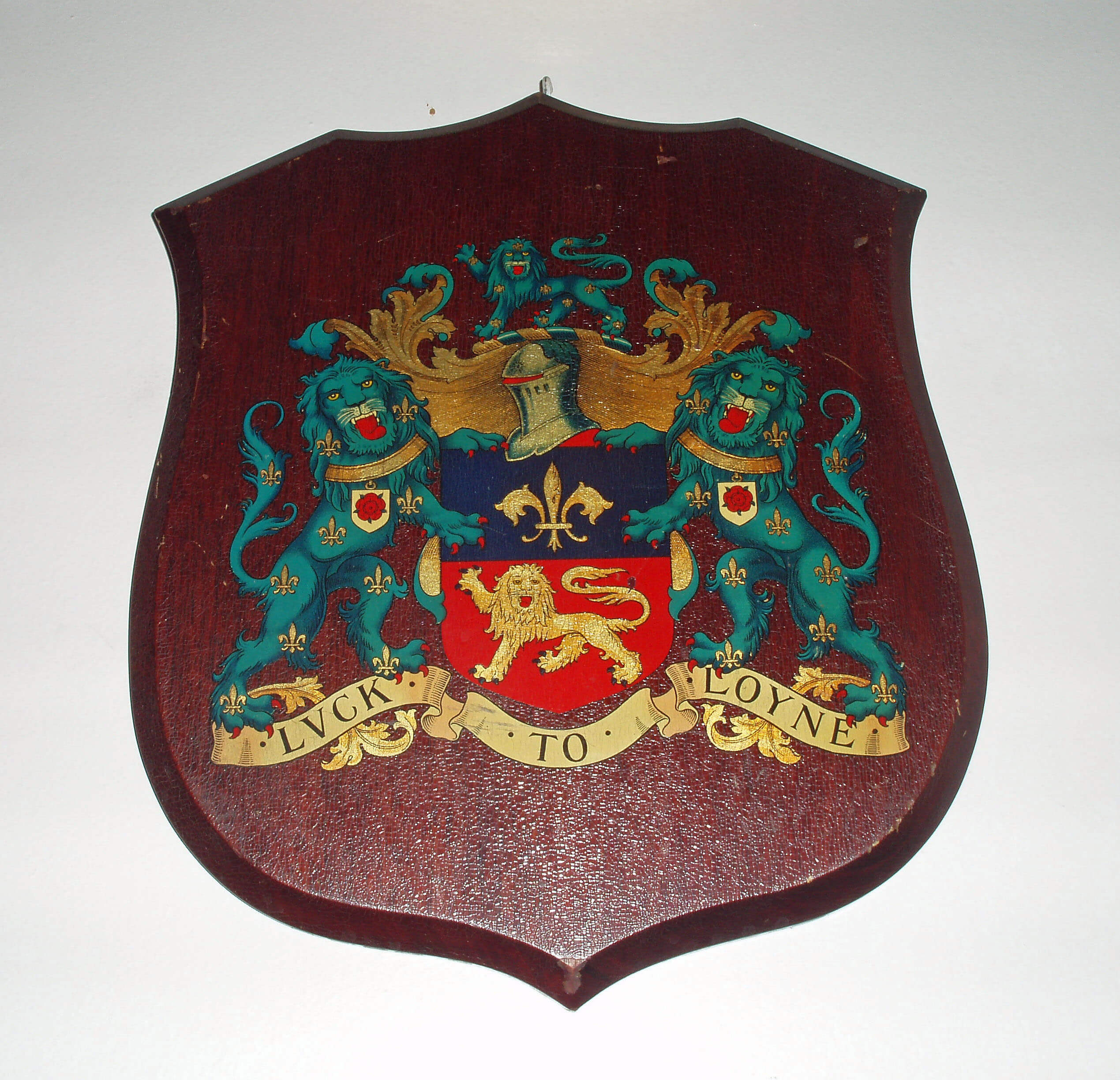 Right: Lancasterĺs ôLuck to Loyneö crest
The phrase ôthe region within the Lune watershedö is
cumbersome. I will co-opt the old, now largely disused,
word ĹLoyneĺ as shorthand for this phrase. ĹLunesdaleĺ
or ĹLonsdaleĺ will not serve my purpose because they are
usually taken to refer narrowly to the valley of the Lune
itself. The few authors who have written on Lunesdale
have some difficulty in deciding how far to creep up the
tributaries ľ Sedbergh?, Bentham?, Ingleton? ů My
rule is simple: if rain falling on an area makes its way to
the Lune estuary then the area is within my scope.
Loyne may seem an artificial construct compared
with the familiar counties and National Parks. In fact,
it is the administrative boundaries that are arbitrary ľ
witness the 1974 creation of the boundaries of Cumbria,
Lancashire and North Yorkshire, with the loss of
Cumberland and Westmorland, and the on-going debate
about changing the National Park boundaries. The Lake
District includes the Shap Fells but not the similar
Birkbeck Fells across the A6, although many regard
both as not really part of the Lakes. The Yorkshire Dales
National Park includes the southern half of the Howgills
but not the similar northern half. Many consider that
the Howgills should not be part of the Dales and would
rather include, say, Wild Boar Fell.
[Update: The 2016 changes to the National Park boundaries made some of the details above incorrect -
but confirmed the point that the boundaries are arbitrary.]
To anyone looking from the Crook oĺLune,
Loyne seems perfectly coherent. Everything we see is
within Loyne, and a great deal of Loyne can be seen.
Ingleborough and Whernside, for example, seem clearly
to belong to Loyne.
The Aim of this Book
The implicit aim of most guides is to encourage readers
to visit that which is described. My aim is the opposite.
I intend to describe a virtual, vicarious journey that may
be enjoyed in an armchair by the fireside, thereby saving
you time, energy and expense and protecting the serenity
and loneliness of Loyne for those who enjoy that sort of
thing, like me. (Reviewers of a draft manuscript have
warned me that readers cannot see the tongue in my
cheek, so I will henceforth do my best to remove it.)
A Note about the Walks
There are outlines of 24 walks in this book. It is strongly
advised that the suggested route be traced on the
appropriate 1:25000 Ordnance Survey (OS) map before
you embark on any of the walks. The descriptions given
here are not adequate unless used in conjunction with the
OS map. The region is covered by maps OL19 (Howgill
Fells and Upper Eden Valley), OL7 (The English Lakes,
south-eastern area), OL2 (Yorkshire Dales, southern
and western areas), OL41 (Forest of Bowland and
Ribblesdale) and Explorer 296 (Lancaster, Morecambe
and Fleetwood).
The outlines do not give step-by-step instructions
as in specialist walking books. The idea is that, once
you have traced the proposed route, you should adapt it
as necessary to suit your own needs. Each route passes
points of interest mentioned in the text preceding the
walk description. Always bear in mind that the walk
details, such as they are, are provided in good faith but
their continued correctness cannot be guaranteed.
All the suggested walks are full-day** (five or six
hour) loops from a car-parking spot. If you can reach the
starting point by bicycle or public transport please do
so. Unfortunately, the details of public transport are too
changeable to be given here.
The walks require a good standard of fitness but
there is no need for the heroic scrambling of some
Lakeland walks. However, some walks do venture into
wild, remote areas and accidents can happen anywhere.
To be on the safe side, here is a list of items that you
should take (created by merging the lists in half a dozen
serious walking books on my shelf): map, compass,
food, drink, waterproofs, hat, gloves, survival bag,
whistle, torch with spare batteries, mobile phone, a GPS
(global positioning system) and three people. The last
are to help carry all the clobber, or you, if you should
have that accident. Always leave information or tell
someone about your intended route and estimated time
of return, check weather conditions and forecasts before
setting out, and wear appropriate clothes and footwear.
(To avoid being hypocritical, I admit that some of my
reconnoitring involved running around with only a map
stuffed in my shorts. Very foolish.)
Walking on the fells had been accepted (except in
the Bowland Fells) even where there was no right of
way. The Countryside and Rights of Way Act 2000 has
provided official access to what I will refer to as ĹCRoW
landĺ. Always enter CRoW land by public footpaths or
official entry points, where there is generally a Ĺwelcomeĺ
sign or a brown Ĺwalking manĺ sign.
The 24 walks are listed in the Index.
[Update: I have dispensed with the Index for this on-line version,
as search engines effectively index on-line text for us.
Instead, I've added the walks to the 'Detailed Contents' below.]
** In this second edition I have, in response to popular
request, added a short walk (about three hours) variation,
wherever possible from the same starting point as the
long walk.
[Update: A reader tells me that they completed versions of
all the walks (23 long and 1 short) in one year "thoroughly enjoying the whole experience"
and "learned much along the way about the history and geology of the area we live in".
They started with walk 24 and proceeded 'backwards' - which was a good idea as the earlier
walks in the book are more challenging.]
Acknowledgements
Writing a general guide such as this is a humbling
experience. I found that every topic, however obscure
ľ be it within history, botany, geology, or whatever ľ on
which I needed to write a sentence or two has been the
subject of a lifetimeĺs devoted study by somebody. In a
non-academic book, extensive references and footnotes
are not appropriate but I am nonetheless very grateful for
their unacknowledged work and hope that they will not
pounce upon me for my superficial misrepresentation of
it.
I will, however, name with gratitude those brave
friends who commented upon a draft manuscript: Jim
Foster, Lesley Jordan, Bob Lauder, Michael Mumford
and Clare Napier. I have done my best to respond to their
views ľ even though it wasnĺt always easy to reconcile
them! Overall, I much appreciated that they found time
for this. As is traditional, I claim full responsibility for
all the errors and faults that remain.
I am particularly grateful for the comments and
encouragement of my son Martin and daughter Pamela,
and for their advice on matters of technology and design.
Without their enthusiasm the project might never have
got underway.
Most of all, Iĺm grateful to my wife Ruth for being
much more of a partner in producing this book than it
appears from the text. Apart from giving opinions and
encouragement and overseeing overall Ĺquality controlĺ,
she accompanied me on many of the exploratory
expeditions. I have mainly used the first person singular
in the text because the reviewers found it disconcerting
to keep switching between ôweö and ôIö, depending on
whether Ruth happened to be there or not, and it seemed
odd for me to write ôweö for those occasions when Ruth
was not present. On all occasions, Ruth was there in
spirit if not in reality.
Feedback
All feedback ľ comments, suggestions, questions,
corrections and updates ľ will be gratefully received. I
have tried to ensure that the content is factually reliable
(but inevitably there will be misunderstandings and
mistakes) and up-to-date (but Loyne covers a large area
and although it may not seem to change much it does
change a little, without telling me). Therefore, all help
in maintaining this on-line second edition will be very
welcome. Please send all comments to me at johnselfdrakkar@gmail.com.
The Flow of the Book
The flow of the book is determined by the flow of the
becks and rivers that eventually reach the Lune estuary.
We will take an imaginary journey in which we follow the
Lune from its source, surveying points of interest nearby,
and whenever we meet a significant tributary we will be
magically transported to the source of that tributary and
will begin a journey from there, eventually to continue
the journey down the Lune. If we meet a significant sub-tributary, we will similarly be transported to its source.
So, for example, when, travelling down the Lune, we
meet the River Rawthey, we will be transported to its
source on West Baugh Fell ľ and in due course when we
meet Clough River, a tributary of the Rawthey, we will
be transported to its source on East Baugh Fell ľ before
eventually resuming our journey on the Rawthey and
later the Lune.
In this way, we will systematically cover every part
of Loyne. The emphasis on the watercourses is partly
a structural device but serves also to highlight their
importance in shaping the character of the region and to
bring to the fore some of its more attractive features. The
imagined flight to the source of the tributaries will take
us from the valleys, where habitation and its consequent
changes are concentrated, to the fells, which change little
from one generation to the next. Throughout Loyne,
the fells provide a reassuring background, supporting a
quiet reflection on the heritage and attractiveness of the
region.
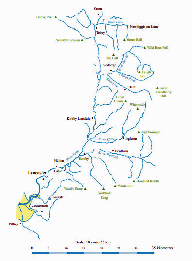
For those who wish to follow the narrative closely,
a more detailed list of the bookĺs
contents is given below, followed by a map of Loyne. Twenty-two
tributaries of the Lune (from Bowderdale Beck to Broad
Fleet) are given section headings. These have single
indents in the list below. Some of the tributaries have
sub-tributaries that have been given section headings. For
example, the River Rawthey has sub-tributaries of Sally
Beck, Clough River and the River Dee. Sub-tributaries
have double indents. A ôůö in a section heading means
that the description of that river is continued in a later
section. For example, the Rawthey is described in four
sections, separated by the three sub-tributaries.
Detailed Contents
Chapter 1: Northern Howgills and Orton Fells
The River Lune ů (Green Bell; the Howgills; Newbiggin-on-Lune)
Bowderdale Beck
Walk 1: A Circuit of Bowderdale, including Green Bell
The Lune from Bowderdale Beck ů (Kelleth)
Langdale Beck (The Calf)
Rais Beck (Sunbiggin; Raisbeck)
Chapel Beck (Orton Fells; Orton)
Walk 2: Orton, Orton Fells and Sunbiggin Tarn
The Lune from Chapel Beck ů (Tebay)
Chapter 2: Shap Fells and Birkbeck Fells
Birk Beck (Shap Fells; Birkbeck Fells; Greenholme)
Bretherdale Beck
The Lune from Birk Beck ů (Roundthwaite)
Walk 3: Roundthwaite Common and Bretherdale
Borrow Beck (Harrop Pike; Crookdale; Borrowdale; Whinfell)
Walk 4: Upper Borrowdale, Crookdale and Wasdale
Walk 5: Lower Borrowdale
Chapter 3: Western Howgills and Firbank Fell
The Lune from Borrow Beck ů (Low Borrowbridge)
Carlingill Beck (Black Force)
The Lune from Carlingill Beck ů (Lowgill; Howgill)
Walk 6: Lowgill and Brown Moor
Capplethwaite Beck (Firbank Fell)
Walk 7: Foxĺs Pulpit and the Waterside Viaduct
The Lune from Capplethwaite Beck ů
Chapter 4: Upper Rawtheydale
The River Rawthey ů (Baugh Fell)
Sally Beck (Wild Boar Fell; the Clouds)
Walk 8: Fell End Clouds, Wild Boar Fell and Uldale Gill
The Rawthey from Sally Beck ů (Cautley Spout)
Walk 9: The Calf via Great Dummacks
Clough River (Grisedale; Garsdale)
Walk 10: Grisedale and East Baugh Fell
Chapter 5: Lower Rawtheydale and Dentdale
The Rawthey from the Clough ů (Sedbergh)
The River Dee (Blea Moor; Dentdale; Great Knoutberry Hill;
Whernside; Deepdale; Great Coum; Dent)
Walk 11: Upper Dentdale and Great Knoutberry Hill
Walk 12: Middle Dentdale
The Rawthey from the Dee
Chapter 6: Middleton Fell
The Lune from the Rawthey ů (Killington; Middleton)
Stockdale Beck (Middleton Fell)
Walk 13: Middleton Fell
The Lune from Stockdale Beck ů (Rigmaden; Mansergh)
Barbon Beck (Barbondale; Barbon)
Chapter 7: Middle Lunesdale and Leck Fell
The Lune from Barbon Beck ů (Casterton; Kirkby Lonsdale)
Walk 14: A Loop between Kirkby Lonsdale and Barbon
Leck Beck (Leck Fell; Gragareth; Leck; Cowan Bridge; Burrow)
Walk 15: Leck Fell, Gragareth and Great Coum
The Lune from Leck Beck ů
Chapter 8: The Greta Headwaters
The River Greta (Chapel Beck) ů (Little Dale; Whernside; Chapel-le-Dale;
Ingleborough)
Walk 16: Whernside from Chapel-le-Dale
Kingsdale Beck (Kingsdale; Thornton Force)
Walk 17: Kingsdale and Yordas Cave
Chapter 9: Gretadale and a little more Lunesdale
The Greta from Kingsdale Beck (Ingleton; Masongill;
Burton-in-Lonsdale)
Cant Beck (Ireby; Cantsfield; Tunstall)
Newton Beck (Whittington)
The Lune from Newton Beck ů (Arkholme; Melling; Gressingham)
Chapter 10: The Wenning Headwaters
The River Wenning ů (Gaping Gill; Clapham)
Austwick Beck (Crummackdale; Moughton; Austwick)
Walk 18: Crummackdale and the Norber Erratics
Fen Beck (Lawkland)
Kettles Beck (Bowland Knotts)
The Wenning from Kettles Beck ů (Newby)
Walk 19: Ingleborough and Gaping Gill
Keasden Beck (Great Harlow; Burn Moor; Keasden)
Chapter 11: Wenningdale, Hindburndale and Roeburndale
The Wenning from Keasden Beck ů (Mewith; Bentham;
Wennington)
The River Hindburn (White Hill; Lowgill)
Walk 20: Middle Hindburndale and Lowgill
The River Roeburn (Wolfhole Crag; Mallowdale; Wray)
Walk 21: Roeburndale
The Wenning from the Hindburn (Hornby)
Chapter 12: The Lune Floodplain and the Top of Bowland
The Lune from the Wenning ů
Farleton Beck and Claughton Beck (Farleton; Claughton)
The Lune from Farleton Beck and Claughton Beck ů (Aughton)
Bull Beck (Caton Moor; Brookhouse)
The Lune from Bull Beck ů
Artle Beck (Wardĺs Stone; Littledale; Caton)
Chapter 13: The Lune to Lancaster
The Lune from Artle Beck ů (Halton; Skerton; Green Ayre;
Lancaster; St Georgeĺs Quay)
Walk 22: Crook oĺLune and Loyn Bridge
Chapter 14: The Salt Marshes
The Lune from Lancaster ...
Burrow Beck
The River Conder (Quernmore; Galgate; Thurnham)
Walk 23: Ward's Stone
The Lune from the Conder ů (Glasson; Overton)
Chapter 15: Into Morecambe Bay
The Lune from the Conder (continued) ů (Sunderland)
The River Cocker (Forton; Cockerham)
Walk 24: Glasson, Cockersand Abbey and Cockerham
Broad Fleet (Nateby; Pilling)
Reflections from the Point of Lune
References and Index
ę John Self