
Home
Preamble
Index
Areas
Dales
Hills
Lakes
Places
Reserves
Rivers
Structures
Villages
References
Me
Saunterings: Walking in North-West England
Saunterings is a set of reflections based upon walks around the counties of Cumbria, Lancashire and
North Yorkshire in North-West England
(as defined in the Preamble).
Here is a list of all Saunterings so far.
If you'd like to give a comment, correction or update (all are very welcome) or to
be notified by email when a new item is posted - please send an email to johnselfdrakkar@gmail.com.
64. Beyond the Leagram Pale
 We set out hoping to see evidence of something that hasn’t existed since 1556. At that date the Leagram Deer Park was disparked. However, the gods were perhaps telling us something when we were confronted by two ‘road closed’ signs on the way there, necessitating long detours through the meandering lanes of southern Bowland.
Eventually we reached Chipping. But we didn't dash straight off. We just had to make use of
the 'environmentally friendly public toilets'.
Chipping's toilets won the best in Lancashire award every year since 2009 until 2014, according to
the Chipping Wikipedia page. So if you have to go, go in Chipping.
Now, at last,
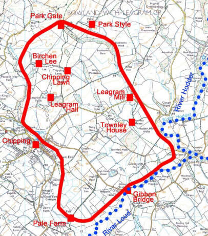
we were able to set off south from Chipping towards Pale Farm. This is on the edge of the
old deer park, with the ‘pale’ referring to the fence that enclosed it. Details of the
Leagram Deer Park are given in
this document,
including on page 30 the map shown.
The park, which was established in the 1340s, was one of more than thirty within or near Bowland. It required a licence from the monarch to create a deer park and it was more a status symbol than a source of income. Fallow deer formed the main quarry, although there was also hunting of other deer, boar, hare and game birds. In order to keep the nimble fallow deer within the park it was surrounded by a ditch (8 feet wide, 4 feet deep for Leagram Deer Park) with a fence or pale on a raised ridge outside it.
The perimeter of Leagram Deer Park measured nearly seven miles and we continued along the line of it, now a hedge, and through the grounds of a hotel to Gibbon Bridge. Here we continued on the south side of the River Loud, where the park boundary no doubt took advantage of this natural barrier. The banks had Himalayan balsam and the river was far from crystal clear, sadly, considering that the water had only flowed a few miles from the slopes of Parlick. Maybe the recent rain had muddied it. The footpath is shown crossing to the north bank but, as we found out, only by means of stepping stones and they were under water, if indeed they were all there. So we retreated to the road to reach Loud Mytham Bridge.
We continued north along the line of the park boundary past Leagram Mill Barn where the
footpath leaves the boundary to head for Knot Hill. This was a pity as there are intriguing
outdentations in the wall along the boundary around Buckbanks Wood (itself a suggestive name)
that are thought to be where there were deer leaps, enabling deer to enter the park but not to
leave. The path to Knot Hill, with an avenue of trees leading nowhere in particular, was the
most English-park-like that we saw even though it was not within the deer park. Knot Hill
itself is half of a small limestone outcrop, the other half having been quarried away.
Knot Hill, only 156 metres high, provided a good prospect of the sunny southern Bowland Fells, Longridge Fell (which was in shade) and a distant Pendle, all of which we saw from time to time throughout the walk.
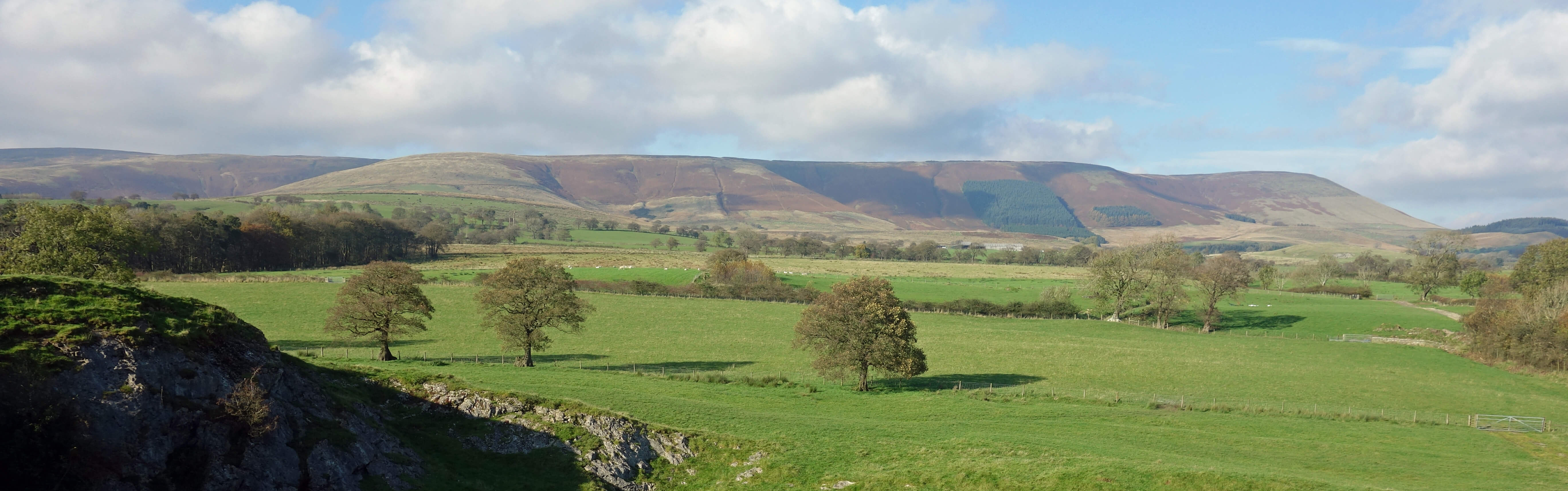
The Bowland hills from Saddle Fell to Totridge, from Knot Hill
On the path to Lickhurst Farm we came upon a dead raptor (a kestrel, I believe). Anyone finding a dead raptor
and thinking that a crime has occurred is supposed to contact the Wildlife Crime Unit. There was nothing
suspicious about this bird other than the fact that it had died in Bowland, where there is a reluctance
to allow raptors to die of natural causes. Recently, the case against a gamekeeper from the nearby
Bleasdale Estate, who was charged with a string of wildlife offences including the killing of
two peregrines, collapsed after the video evidence was deemed inadmissible in court.
The evidence is not inadmissible here.
We returned to the deer park boundary at Park Style (which was derelict) and Park Gate (which wasn’t), at the northernmost part of the park. The boundary continued a little to the west but we were beginning to tire of searching for stiles to enable us to walk through yet more muddy fields, so we dropped south past Chipping Lawn (from ‘laund’, which was a clearing where deer grazed) to pick up the boundary again near Leagram Hall, which was the base for the deer park. We had no view of the hall.
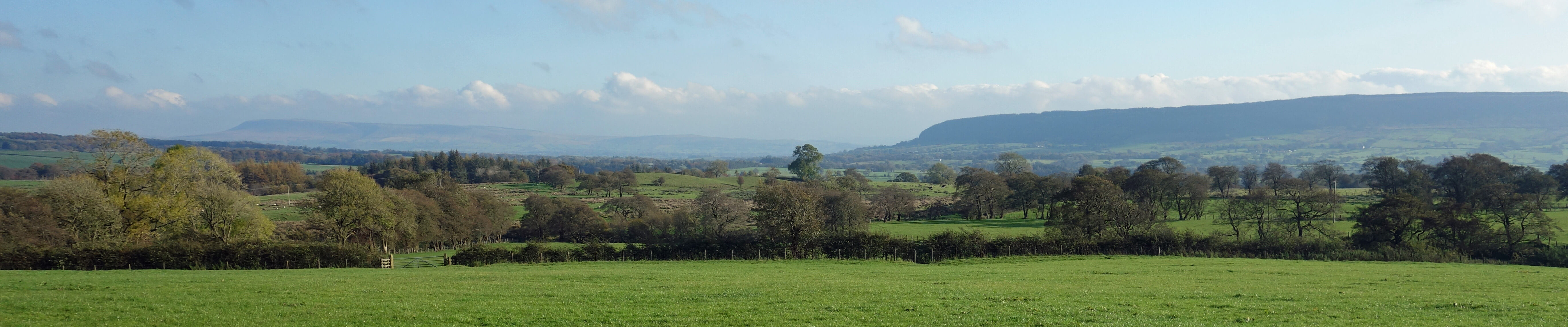
Looking over the old deer park towards Pendle (faint, to the left) and Longridge Fell
It seems almost needless to say that we saw no deer, boar or hares and that the only game birds seen were non-native pheasants. We had followed a succession of hedges, walls, fences, tracks and roads that are on the line of the boundary of the old deer park. However, none of those hedges, walls, fences, tracks and roads seemed different to others, as far as we could see. There was nothing we could point to and say “aha, that’s obviously to do with the deer park”. But then it has had 463 years to disappear.
Date: October 23rd 2019
Start: SD621433, Chipping (Map: OL41)
Route: SE, S – Pale Farm – E, NE – Gibbon Bridge, Bailey Hippings – S, NE –
Loud Mytham – NW, N – Knot Hill, Lickhurst Farm – SW – Park Style, Park Gate – S, W – Birchen Lee – S –
Chipping
Distance: 8 miles; Ascent: 115 metres
Home
Preamble
Index
Areas
Dales
Hills
Lakes
Places
Reserves
Rivers
Structures
Villages
References
Me
© John Self, 2018-

Top photo: The western Howgills from Dillicar;
Bottom photo: Blencathra from Great Mell Fell