
Home
Preamble
Index
Areas
Map
References
Me
Drakkar
Saunterings: Walking in North-West England
Saunterings is a set of reflections based upon walks around the counties of Cumbria, Lancashire and
North Yorkshire in North-West England
(as defined in the Preamble).
Here is a list of all Saunterings so far.
If you'd like to give a comment, correction or update (all are very welcome) or to
be notified by email when a new item is posted - please send an email to johnselfdrakkar@gmail.com.
60. The Longsleddale Green Lane
Referring to Longsleddale, Baddeley (1880, 1922) wrote that “it is difficult to picture a scene in which peace, contentment and beauty are more happily combined.” I couldn’t put it better myself. Which is why I haven’t tried to and have quoted Baddeley instead. However, this peace, contentment and beauty has not been easily won and may be easily lost.
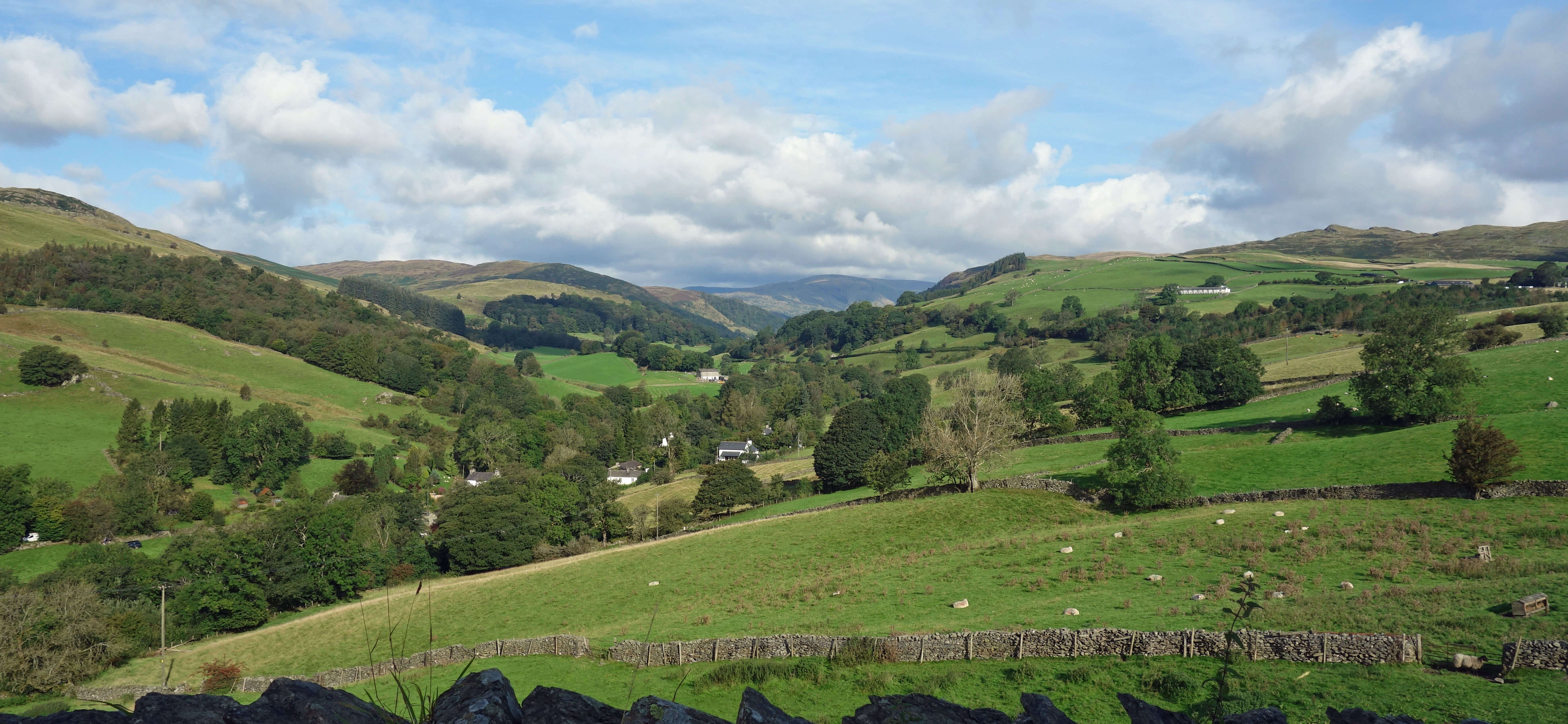
Longsleddale from the A6
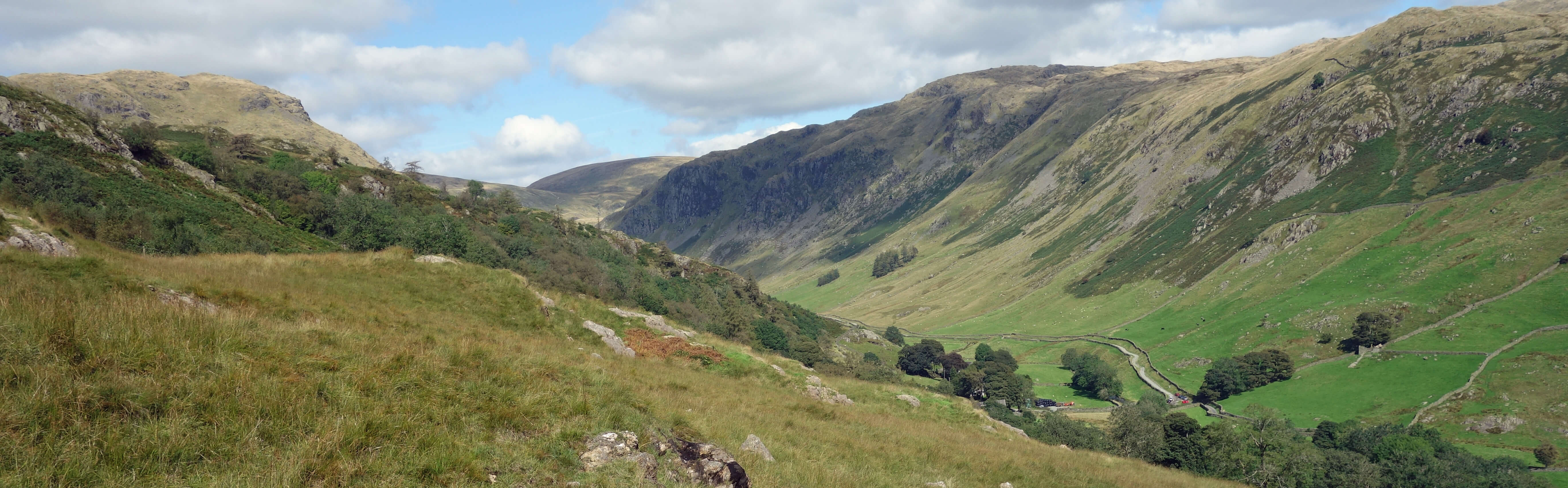
Compared to the almost empty dales to the north (such as Bannisdale and Borrowdale), Longsleddale is well-populated. At the bottom of the valley, by the A6, there are several houses gathered around Garnett Bridge, and above them farmsteads and homesteads dot the valley throughout, on both sides of the River Sprint. As we strode up the valley, doing our best to ignore the blackberries, the houses thinned out and so did the traffic, although it was never exactly relaxed walking, having to squeeze into the hedge from time to time.
Longsleddale is indeed long. It is five miles to Sadgill at the end of the road and a further three miles
to the head of the dale, at the top of the Gatescarth Pass. The hills on both sides of the lower
valley rise to 400 metres or so, providing shelter for the farms below. The small, flat fields here result from the series of glacial lakes separated by rock bars that long ago occupied the dale. In 1845 a Longsleddale reservoir was planned in order to regulate the water supply to the various mills along the valley but it was never built. I expect that Manchester had its eye on the valley for a reservoir too, as it did for most valleys in the region. In the end Manchester Corporation used Longsleddale only for the Haweswater Aqueduct which runs, inconspicuously now, through its eastern hills. A proposal to lay a second pipe-line through the valley bottom of Longsleddale, which would have required the building of a wider road for access, was rejected by government in 1965.
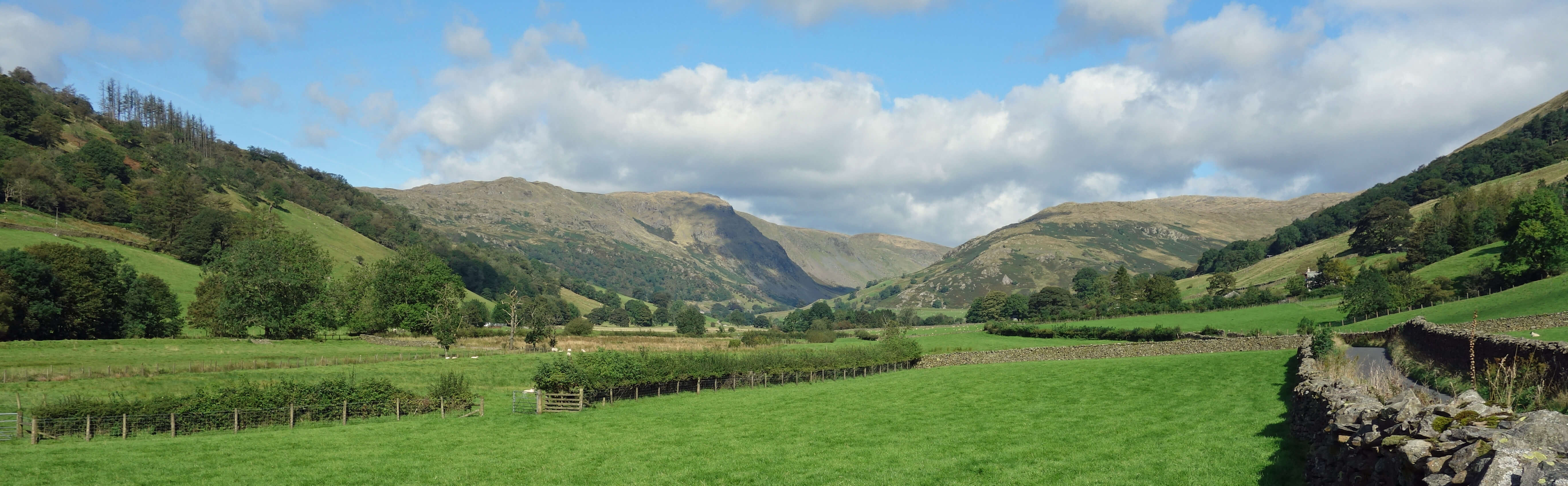
Longsleddale
We walked on, passing a barn/garage which on its side indicated the mileages to London, Edinburgh and Yarmouth. No, I have no idea. The valley opened out, providing views of the head of Longsleddale, where the Gatescarth Pass curves up between cliffs. The fact that the road is a dead-end obviously decreases the traffic and it may be fortunate that the road is still a dead-end. According to Berry and Beard (1980), in the 1960s it was proposed to extend the M6 north from Carnforth by taking it up Longsleddale and then by tunnel under the Gatescarth Pass to Mardale. I find it hard to believe that this option was seriously contemplated. I suspect that the planners offered Longsleddale as an option because it was so patently unpalatable that their preferred, still unpalatable but less so, option would be gratefully adopted. Perhaps much the same can be said about an 1840s proposal to route the Lancaster to Carlisle railway through Longsleddale and by tunnel into Mardale.
Longsleddale is narrow and it becomes narrower still beyond Sadgill, as it is squeezed between
Goat Scar and Buckbarrow Crag. The change of scenery reflects the transition from Silurian to Borrowdale
Volcanic rock. The metalled road ends and the rough track of the Gatescarth Pass continues between Harter
Fell and Branstree, reaching a height of 572 metres (for comparison, Kirkstone Pass, the Lake District’s highest
road pass, reaches 454 metres) before eventually dropping down to the head of Haweswater in Mardale.
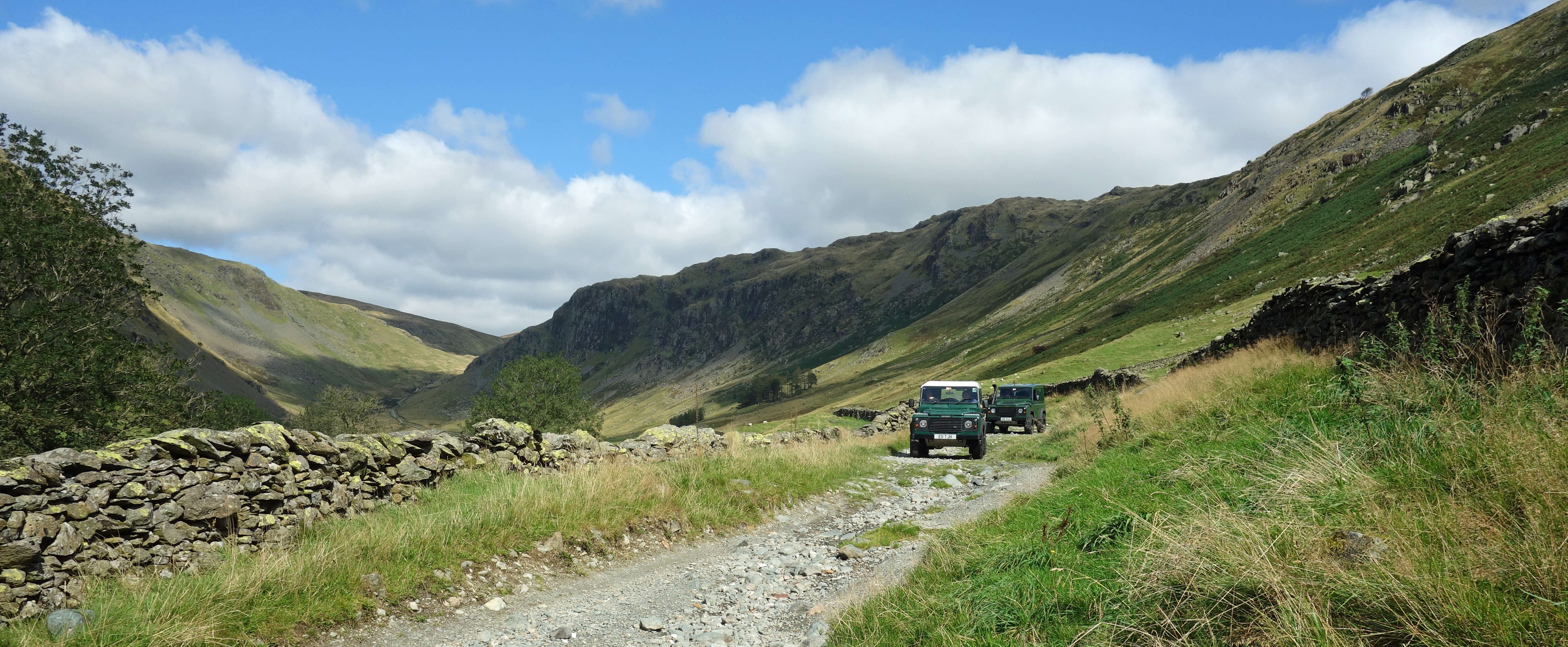
We walked a little way up the Gatescarth Pass track in order to gain a better view and were
confronted by two 4x4s coming down (shown left below). This was not a surprise to us because we had selected
this day to visit Longsleddale precisely because it was the one day in the month when off-road vehicles
and motor-bikes may be given permits to cross the pass from Mardale to Sadgill. The Lake
District’s ‘green lane’ policy remains
highly controversial.
A green lane is an unsurfaced public way that may be used by recreational vehicles. There are, of course, objections to the noise and damage caused and many walkers do not appreciate being barged off their paths. A compromise is being sought on the Gatescarth Pass, in allowing vehicular access for just one day a month.
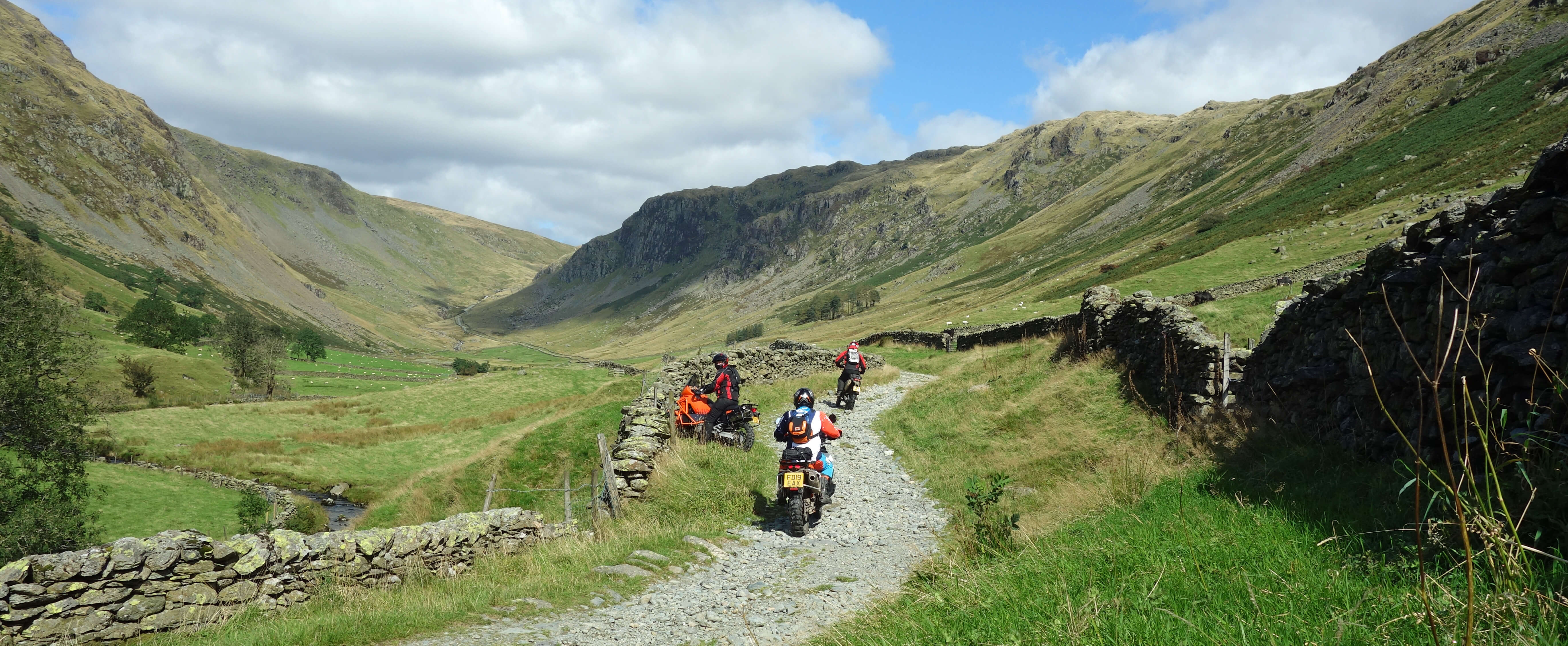
We sat and waited in case more 4x4s would come along but instead a group of ten bikers tackled the track from the Sadgill direction.
Three of them are shown in the photograph above right. This is at the lower, gentle end of the pass.
The second biker had lost
control of his bike and nearly hit the wall. I hope that he got the hang of it before reaching the
steeper, rockier and bendier parts of the pass.
We saw the bikers returning later and assume that they were taking advantage of the fact that the Traffic Regulation Order that
limits access to the Gatescarth Pass only begins to apply 1˝ miles up the pass. They were scrambling up, to turn and then scramble down. They could, in fact, do this on any day. I suppose 4x4s could as well – although they may be unable to turn.
From Sadgill we followed the track that leads to Kentmere. This also may be used by 4x4s, at any time. For centuries it was, like the Gatescarth Pass, part of the main east-west route in the Lake District. This ran from Ravenglass, over Hardknott and Wrynose, to Ambleside, Kentmere, Sadgill, Mardale and Shap. A petition of 1717 described it as a “great road and public highway … very much used by travellers, drovers and others having occasion frequently to pass” (Hindle, 1984). We only walked up the track to gain a higher view of Longsleddale and then dropped down to the bridleway that continues on the south side of the River Sprint all the way to Garnett Bridge. We walked through many grassy fields and past numerous houses, quite a few of which were undergoing renovation. It was an uneventful return walk, entirely peaceful apart from the occasional biker on the road opposite.
Looking down to Sadgill and the start of Gatescarth Pass from the track to Kentmere
I had anticipated, before taking this walk, that this final paragraph would be a coruscating criticism of
the green lane policy that allows vehicles to disturb the serenity of Longsleddale and to damage the
ancient track of the Gatescarth Pass. Now, having familiarised myself with the long length of Longsleddale,
I am inclined to reflect that Longsleddale has overcome much greater actual and potential threats in
the past than that of a few individuals driving vehicles over the pass. The Gatescarth Pass has
survived centuries of herds of cattle being driven over it and of heavy quarry traffic. Longsleddale
can absorb and largely ignore the, to my mind, rather silly and hopefully temporary activity of off-road vehicles.
Of course, I would prefer that there were no traffic at all on the Gatescarth Pass; that the
Traffic Regulation Order applied to the whole of the pass so that bikers are discouraged from roaring
along Longsleddale; and that men (it is always men) did not feel urged to gain their thrills by driving
their macho machines here. Saddened as I am by the treatment of the green lane of the Gatescarth Pass,
I will prefer to think instead of the green bridleway of Longsleddale where peace, contentment and beauty
will always be found, I hope.
Date: September 7th 2019
Start: SD527980, A6 layby at Garnett Plain (Map: OL7)
Route: W, NW on road – Sadgill – S, E past Till's Hole – River Sprint –
SE on bridleway – Garnett Bridge – E, SE, E – layby
Distance: 11 miles; Ascent: 140 metres
Home
Preamble
Index
Areas
Map
References
Me
Drakkar
© John Self, Drakkar Press, 2018-

Top photo: The western Howgills from Dillicar;
Bottom photo: Blencathra from Great Mell Fell