
Home
Preamble
Index
Areas
References
Me
Saunterings: Walking in North-West England
Saunterings is a set of reflections based upon walks around the counties of Cumbria, Lancashire and
North Yorkshire in North-West England
(as defined in the Preamble).
Here is a list of all Saunterings so far.
If you'd like to give a comment, correction or update (all are very welcome) or to
be notified by email when a new item is posted - please send an email to johnselfdrakkar@gmail.com.
38. Reflections from Jeffrey's Mount
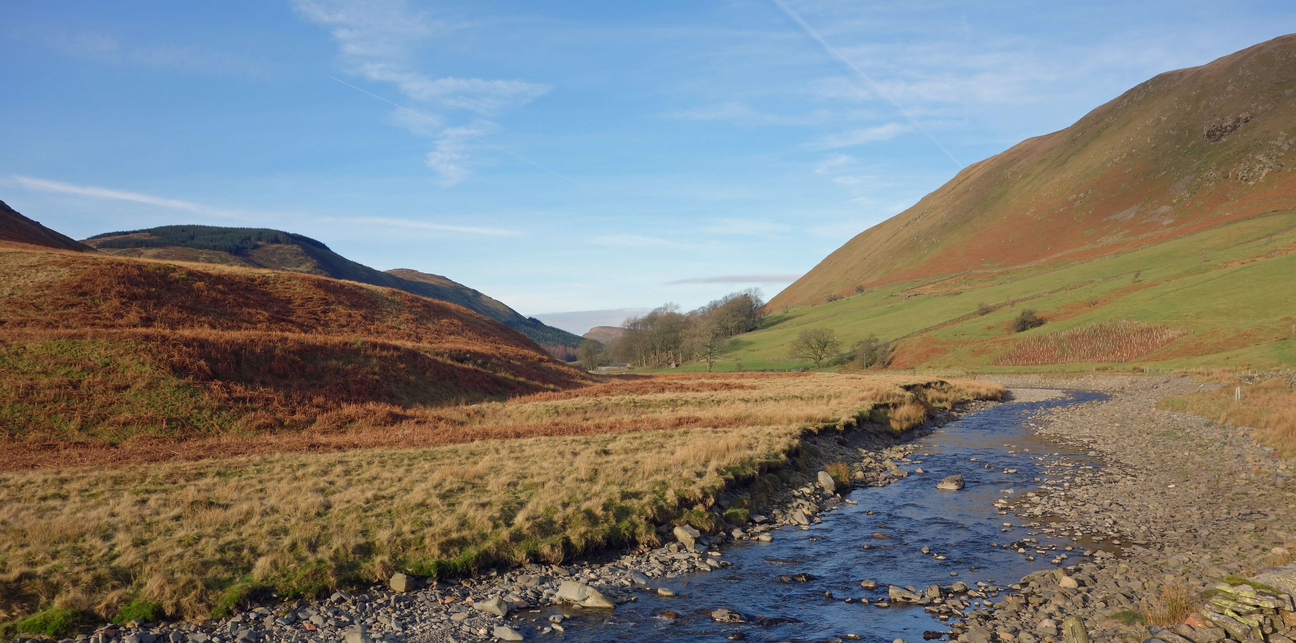 Right: Borrow Beck in Borrowdale.
A new year is always a time for reflection. My struggles with a book about ôhow to aesthetically appreciate the
natural environmentö (Carlson and Berleant, 2004) have provoked me to reflect on the natural environment of
North-West England. I have battled with many abstruse words and dense paragraphs to try to grasp the object model,
the landscape model, the scientific model, the arousal model, and so on, and with concepts such as aspection, numinousness,
etiology, noesis, and so on, but I am left with one preliminary question: What natural environment?
There is no fully natural environment in North-West England, although it comes closer to it than most places in
England. There is nowhere that I may stand without being able to see some human intervention with nature. I realise
that humans are part of nature too and that it could be argued that, say, the Midland Hotel in Morecambe is as natural as a
waspÆs nest. However, the book doesnÆt argue this. It focusses upon mountains, waterfalls, forests, whales, and the like.
It seems to me that any attempt to discuss the aesthetics of our environment as it is today must include the effects of
humanity upon it, although this factor is largely ignored by Carlson and Berleant (2004). If there is a spot in our
region where I cannot point to, for example, a building, road, field, pylon, moor, weir, or plantation then I am
sure that I need only point to the contrails of the many jets that cross our region. One morning recently, as I was
grappling with these thoughts about nature, I noticed in the dark sky a thin crescent of the moon, bright white from
the not-yet-risen sun. What could be more natural? Then I saw that three jets were in the process of enclosing the
moon in a bright white triangular frame.
I walked into Borrowdale (the one near Tebay, not the one near Derwent Water) through Borrowdale Wood. Is this a
ænaturalÆ wood? It certainly looks like an old natural woodland to me. However, the authorities concerned about our
woodland hedge their bets û their formal designation of such woodlands is æAncient Semi-Natural WoodlandÆ in recognition
of the fact that our woodlands have been managed for centuries to provide wood for various purposes.
Borrowdale was described in Wainwright (1972) as ôthe most beautiful valley in Westmorland outside the Lake Districtö.
Today it is not in Westmorland and is inside the Lake District. But it is still beautiful.
Is it natural? There
are aerials on the Whinfell ridge, conifer plantations on Mabbin Crag, farms, roads and tracks to them, bridges, fences,
walls, and, on this occasion, one helicopter, two low-flying jets, many high-flying jets, and a distant but appalling
(for someone focussed on the natural and unnatural, as I was) view of what seemed to be at least four conflagrations on the North Pennine
moors, as heather was being burned for the grouse. At least there are no wind turbines or reservoirs in Borrowdale, as have been threatened in the past.
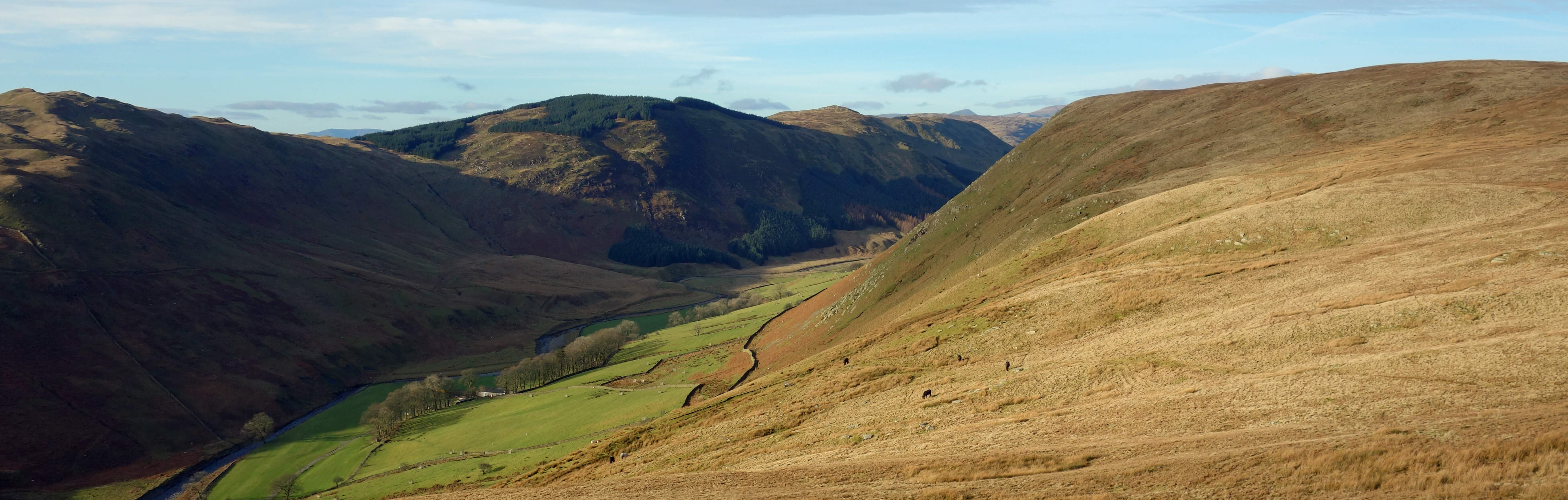
Borrowdale from Belt Howe
I walked past sheep and fell ponies û and we could debate whether they are natural here û along the ridge to JeffreyÆs Mount. From the small cairn at the top I wandered east to gain a full view of the so-called Lune Gorge but not too far to the east as it is a steep slope with a small cliff at the bottom from which to fall onto the A685. As I stood there idly watching the world dashing by below, I day-dreamed about previous activities in the Gorge.
ItÆs 19 AD. It is quiet. The hills are covered with trees. The River Lune runs, unseen, in the valley. ThereÆs a path there for those taking advantage of this natural gap in the hills to travel between north and south.
ItÆs 150. I can hear hundreds of Roman soldiers in their barracks below in the rectangular green field at
Low Borrowbridge.
To the south I can see a legion marching along the Fairmile Road, having walked from the fort at Burrow or Ambleside. To the north further soldiers are heading towards Carlisle walking up Crosby Ravensworth Fell, beyond the Tebay Service Station.
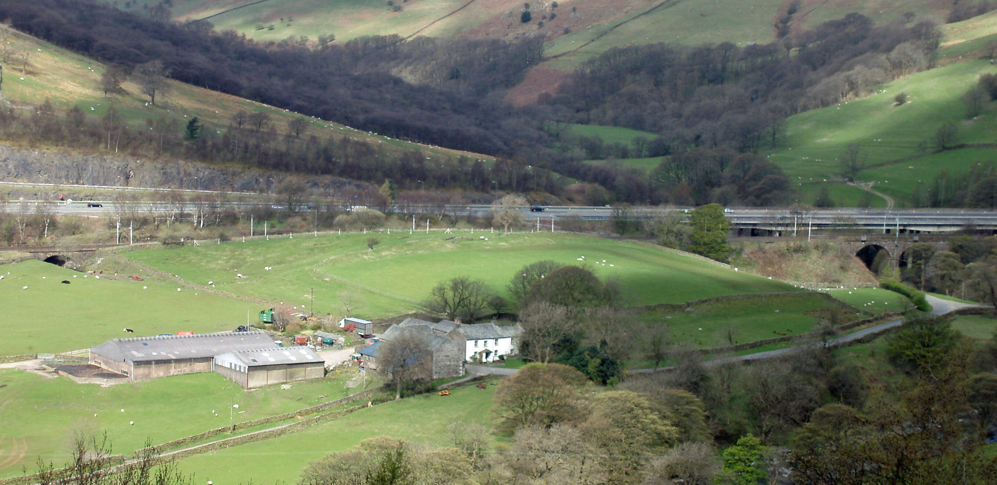
Right: Low Borrowbridge Roman fort (photo taken on a previous occasion, from the opposite bank
of the Lune Gorge).
ItÆs 1100. Men are working to build a motte-and-bailey castle
(Castle Howe)
by a bend of the River Lune near Tebay. The site is clearly of strategic importance to the Normans. It is a castle of wood, not stone, as it is for administrative rather than defensive purposes. ThereÆs a track below towards the next motte-and-bailey down the Lune valley, at Sedbergh.
ItÆs 1500. The trees have gone from the hills, removed by sheep-farmers. Scottish raiders can be seen moving along the valley.
ItÆs 1750. I can see herds of cattle on the drove road below and hear the accompanying din. Villages on the way, such as Greenholme and Roundthwaite just to the north, are making the most of this passing trade. Herds from Galloway are funnelled through the Lune Gorge to swing west below Grayrigg Common to continue on the Lune watershed towards Kirkby Lonsdale.
ItÆs 1840. The busy but narrow road from the south swings east past Low Borrowbridge Inn and then north over a bridge over Borrow Beck. A mile north, before LuneÆs Bridge crosses the Lune, a side-road leads north through Roundthwaite. The road through Tebay crosses the Lune at Tebay Bridge and continues to Orton. These two roads form the main thoroughfares north from Lancashire.
ItÆs 1920. Tebay is a major railway junction with an agglomeration of sidings and engine sheds. A branch line turns east to Appleby and the London and North Western Railway to Scotland, completed in 1846, continues up a steep slope to Shap. It is so steep that extra engines are based in Tebay to give the steam trains more oomph. To the south a branch line to Ingleton over the Lowgill Viaduct can be seen.
ItÆs 1980. The Tebay station and its branch line have closed. The old road (the A685) no longer
crosses the Lune at LuneÆs Bridge (now a dead-end) but at a large new bridge south. The A685 has been shifted west,
necessitating the removal of a chunk of JeffreyÆs Mount, to enable the M6 to pass through the Gorge. The M6 engineers
have been given a
Civic Trust Award
for ôan outstanding contribution to the appearance of the Westmorland landscapeö.
The index of Carlson and Berleant (2004) doesnÆt mention motorways. The book is
concerned with the ænatural environmentÆ and the award is concerned with the ælandscapeÆ
and they are not the same thing, as many erudite treatises no doubt explain. So I turned
to a chapter (Halpern, 2004) that began with the sentence ôWhat is it to appreciate
a landscape aesthetically?ö This does mention motorways û once. It says ômany people à feel
revulsion at the slicing of a down à by a motorway cuttingö. Do they feel revulsion
at the slicing of a northern upland? Are our uplands more suited to
slicing by motorways? Are our northern sensibilities less susceptible to
revulsion? Have our feelings of revulsion been exhausted by the
railway and A685 that already slice through the gorge? Perhaps someone should write a book on how to feel aesthetic revulsion at the unnatural environment.
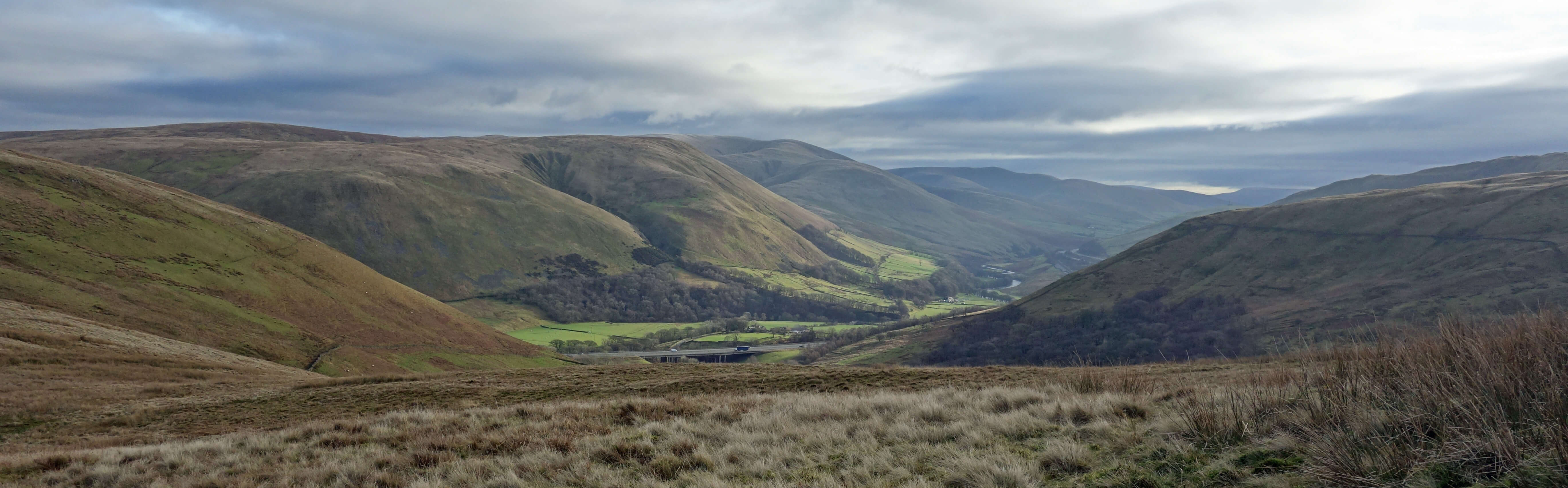
The M6's Borrowbeck Viaduct nestled within the Lune Gorge, from Casterfell Hill
ItÆs 2019. It is not quiet. There is no respite from the loud rumble of the M6 plus the
occasional clatter of express trains. In a few places the Lune may be glimpsed, having been
flowing through all this traffic for centuries and now winding its way under many bridges.
But look! Trees (hawthorn, blackthorn and alder) have recently been planted on Tebay Fell, as
they have been in Borrowdale. For the first time in 2,000 years we seem to have acknowledged
that we cannot just exploit the natural environment of the Lune Gorge but that we need to restore
it and protect it. Sadly, no, the tree-planting is, as always, utilitarian, being intended to
reduce flooding down-river. Well, I was day-dreaming.
Date: January 9th 2019
Start: NY611029, layby on the road to Roundthwaite, overlooking the M6 (Maps: OL19, OL7)
Route: S on A685 û Borrow Beck û W, NW by
Borrow Beck û Low Borrowdale û E û Belt Howe, Casterfell Hill, JeffreyÆs Mount û N û Roundthwaite û SE û layby
Distance: 6 miles; Ascent: 240 metres
Home
Preamble
Index
Areas
References
Me
® John Self, 2018-

Top photo: The western Howgills from Dillicar;
Bottom photo: Blencathra from Great Mell Fell