
Home
Preamble
Index
Areas
Dales
Hills
Lakes
Places
Reserves
Rivers
Structures
Villages
References
Me
Saunterings: Walking in North-West England
Saunterings is a set of reflections based upon walks around the counties of Cumbria, Lancashire and
North Yorkshire in North-West England
(as defined in the Preamble).
Here is a list of all Saunterings so far.
If you'd like to give a comment, correction or update (all are very welcome) or to
be notified by email when a new item is posted - please send an email to johnselfdrakkar@gmail.com.
68. Landscape and the Howgills
 Nowadays, 'landscape' is how you orient your page if you don’t want ‘portrait’. There is rather
more to the concept of landscape than this but I hadn’t appreciated how much more until I read the book
Landscape (Wylie, 2007).
Nowadays, 'landscape' is how you orient your page if you don’t want ‘portrait’. There is rather
more to the concept of landscape than this but I hadn’t appreciated how much more until I read the book
Landscape (Wylie, 2007).
I was taken on an exhilarating journey through all of geography – landscapes are to geography as plants are to botany, according to some landscapologists – plus parts of philosophy, psychology, politics, history, aesthetics, art, culture, epistemology, phenomenology, imperialism, race, class and feminism. That is too long a journey to embark on in one Sauntering although I can mention one crucial junction along the way. This is the thought that our modern conception of landscape was developed in recent centuries by ‘landscape gardeners’, ‘landscape painters’ and those that paid for their work, who were almost all wealthy white men. It is possible that those of us who are not wealthy white men have a different conception of landscape.
After our fortuitous foray to Arant Haw last week
[67], I have been wondering why I am disproportionately fond of the
landscape of the Howgills compared to other regions of the north-west. Mindful that
the M6 engineers had in 1971 been given a Civic Trust Award for “an outstanding
contribution to the appearance of the Westmorland landscape”, I parked as close to the
motorway as possible, in case the M6 has something to do with it.
Some landscapologists insist that there is more to landscape than appearance. We hear, smell and feel the landscape too. In this respect, the M6 is not merely outstanding: it is overwhelming. It swamped all other sound – except that of the occasional train that whooshed by. In fact, after a while I came to accept the constant noise of the motorway as a permanent feature of the environment, a bit (but not much) like the sound of waves on a beach. It is the sudden clatter and rattle of the trains that is more disturbing.
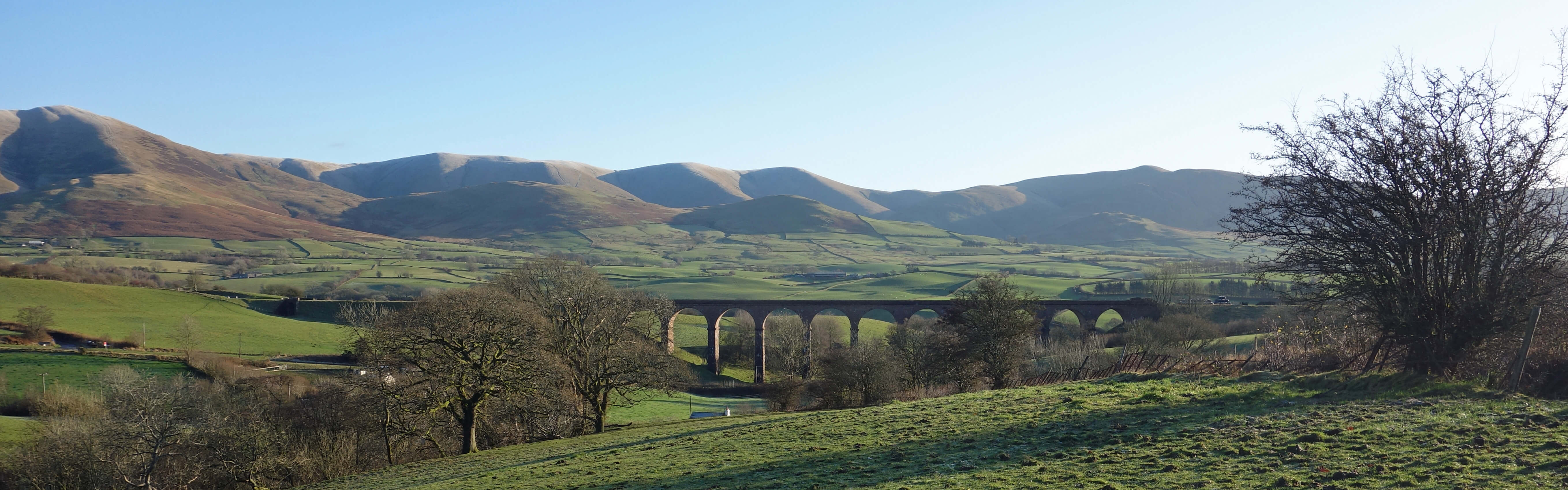
Lowgill Viaduct and western Howgills
The M6 became less overwhelming as I walked towards the Lowgill Viaduct, with the rolling, smooth, interlacing western slopes of the Howgills forming a backdrop. I think I can agree with landscapologists that there is no such thing as ‘the landscape’, at least not in the sense that there is ‘the Lowgill Viaduct’. The latter is a tangible, physical object that we can touch and, in this case, walk under. The former is more an interpretation that we place upon the array of physical objects on the land – and that interpretation is different for all of us.
I have become more aware of this recently. After decades of running on the hills I had become accustomed to viewing the landscape with respect to its runnableness. It was not a deliberate, conscious reflection: it just happened without me being aware of it. I am aware of it now because I find that I am still assessing runnableness even though I am no longer running. I pull myself up, smile and tell my brain to behave. So I know that I appreciate the landscape in a particular way and I therefore assume that everybody else does too. Everybody has a particular mix of interests and experience – photography, farming, climbing, walking, painting, and so on – that they bring to bear, without their awareness, whenever they appreciate a landscape.
The same is true, if to a lesser extent, with everything we perceive, even the
Lowgill Viaduct. Engineers, artists, historians and so on will see the viaduct differently.
And, of course, our perception of structures like the viaduct may change over time.
No doubt, when it was built in 1859 some people reacted then much as I do to the M6 today. Now, especially as it no longer carries trains, we might consider it to make an ‘outstanding contribution’ to the landscape as well.
My unreasonable fondness for the Howgills landscape probably derives from a subconscious perception of its runnableness. Its long, smooth ridges are a delight for a runner to glide over, at least compared to the steep, rocky inclines of the Lake District, the uneven, fragile limestone pavements of the Dales, and the heathery, boggy plateaus of the Pennines. Almost all the slopes of the Howgills can be run up by a reasonably fit person, and I am sure that when I look at the Howgills now I am affected by an instinctive memory of running up and down them all in the past.
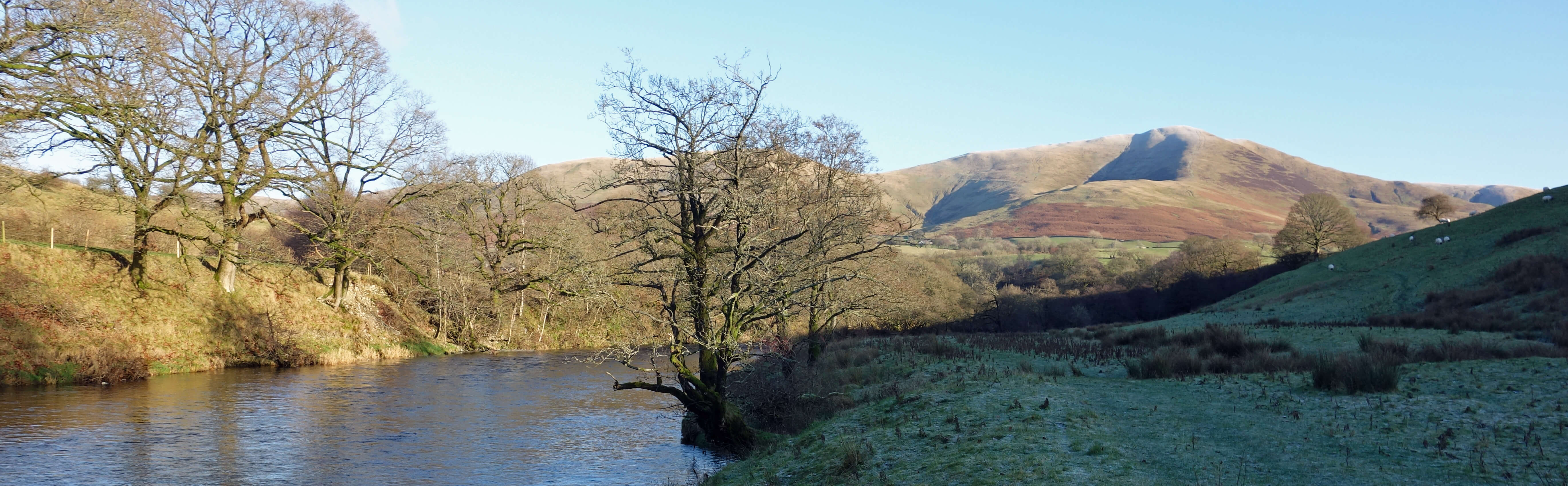
River Lune and Fell Head
I walked under the viaduct and over the quaint, narrow Crook of Lune Bridge, which
was damaged by Storm Desmond in 2015 but seems in order now, and then north by the
River Lune past the old farms of Brunt Sike, Mire Head, Low Wilkinson’s and Howgill Head,
only one of which seems to be farming today. The noise of the motorway still dominated.
If landscapologists are right to say that landscape is more than something to gaze at and that it involves the other senses too then it follows that we need to get closer so that those other senses come into play. This leads to the conclusion that we too are part of the landscape, which means that we need to consider all the complexity of humanity to understand landscape. The notion that we are part of the landscape is no revelation to walkers. We know that what we see now as a landscape is where we’ll be in two hours time – and in two hours time where we are now will be seen as a landscape. So with the reassuring thought that landscape is neither here nor there I pressed on.
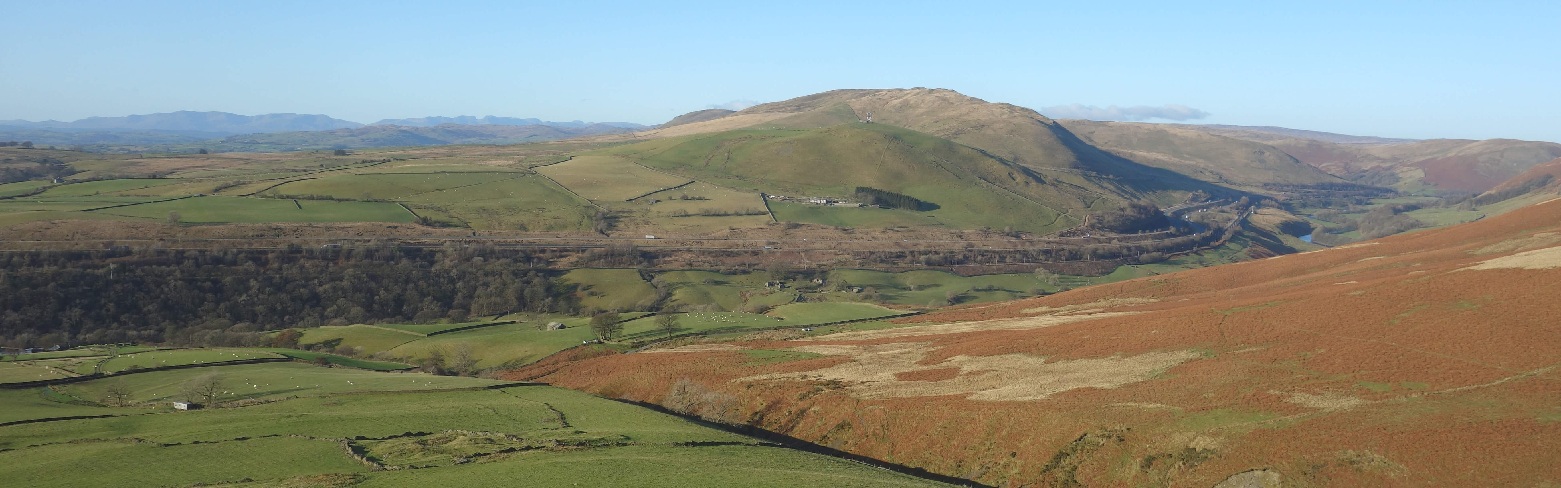
From Whin's End towards the Lake District, with the M6 in the middle distance
Crossing the Fairmile Road (the old Roman road), I walked up by Fairmile Beck to Whin’s End (384 metres). The Lake District hills from Black Combe
to Great Gable could be seen, with the motorway now humming away gently in the middle distance.
As I dropped over the col to Brown Moor (412 metres) the sound of the M6 at last disappeared. In fact, it was eerily quiet and empty, with no sheep or fell ponies or walkers to be seen. The western slopes of the Howgills’ highest tops (Fell Head, Bush Howe, the Calf, Bram Rigg Top) were elegantly displayed, with the low sun picking out their gullies. Another reason why the Howgills are appreciated as a landscape is that no one top stands alone. The smooth slopes merge them into one and the eye naturally flows along them.
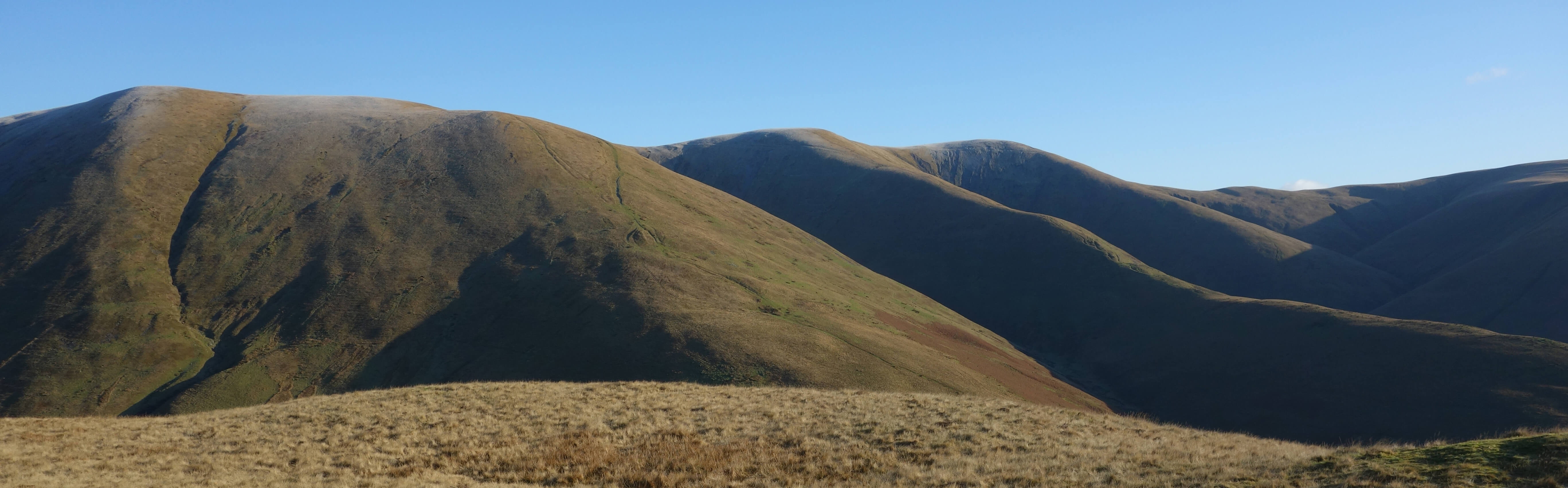
From Brown Moor towards White Fell Head and The Calf
I walked over to Castley Knotts (361 metres), which has, unusually for the Howgills,
a few rocky outcrops. Again no sheep or ponies could be seen on the fells although I
could see one ‘horse’ – the so-called Horse of Bush Howe, where exposed scree resembles
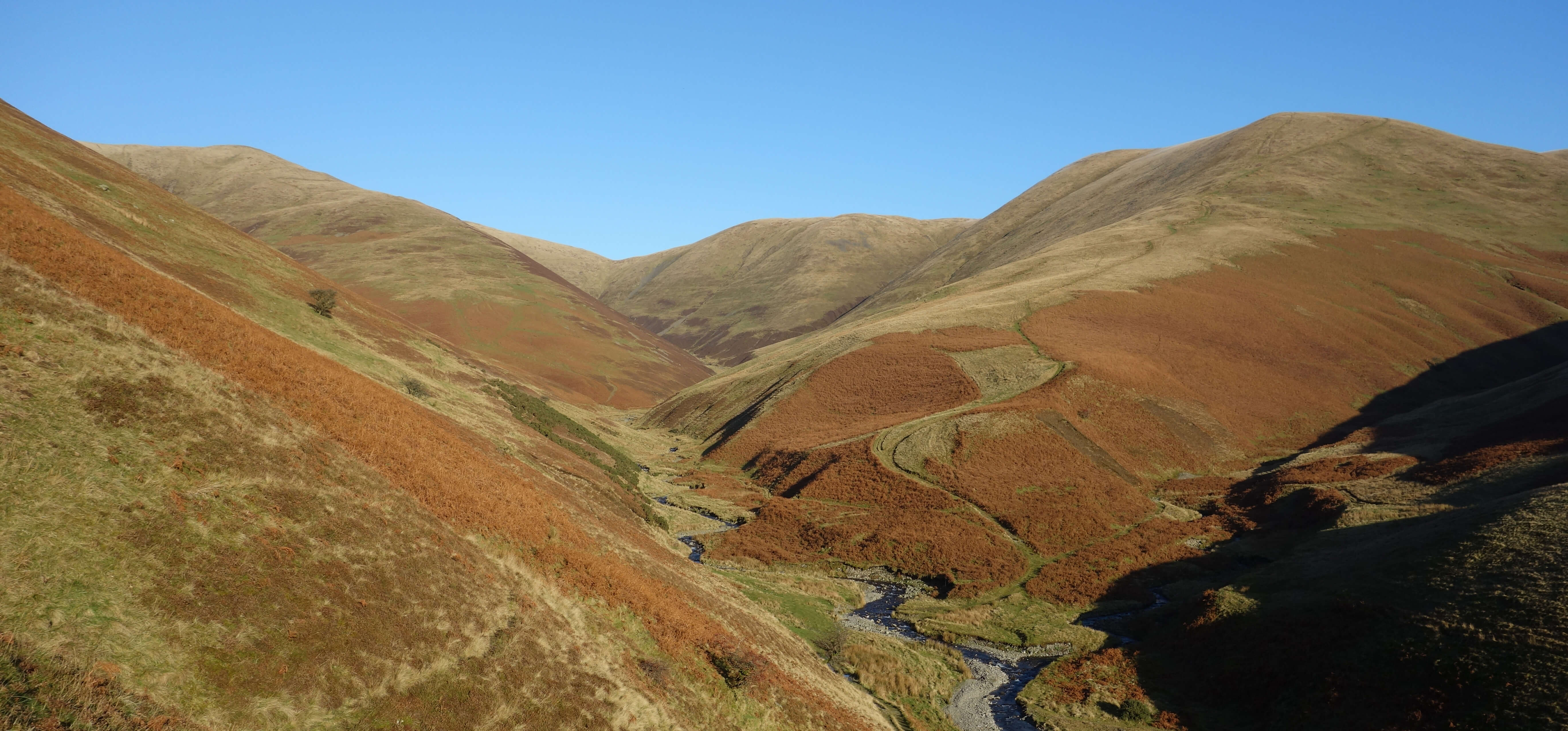
the shape of a horse, although less so every time I see it. I crossed Chapel Beck,
with difficulty, and walked over Bram Rigg to cross Bram Rigg Beck, also with difficulty.
I then left the foothills of the Howgills to drop down to the River Lune to follow the
Dales Way back to the Crook of Lune Bridge.
Here at least there was no sound of the motorway, the swirling Lune overcoming it. The last time I walked along this path I came across two women swimming in deep pools of the Lune – au naturel, as I recall although my memory may be embellishing the scene. I always like to see wildlife on my walks but I did not expect to see similar in November, with the sun having dropped below Firbank Fell and with frost still on the grass. And I didn’t, try as I might. My mind has wandered, sorry … I must return to the concept of landscape.
Chapel Beck from the slopes of Castley Knotts, with the
so-called Horse of Bush Howe in the middle, near the horizon
My camera tells me that I am taking ‘landscape’ photographs. Indeed, I have peppered this blog with what
I would think of as landscapes, including one of the Howgills as the banner above. Some I have stretched wide
and thin to emphasise their panoramic nature. I must have felt, when I began this blog, that such photographs
convey the appropriate impression of the region. North-West England is a land of landscapes, especially
if you are prepared to walk up a hill to view them.
Landscape photography is today an art form, with
its own prizes (for example,
Landscape Photographer of the Year), that
perpetuates the old-fashioned view that landscape is primarily something to be looked at.
Photography is not mentioned in the Wylie (2007) book but it does include the comment that “cultural forms (art, literature, fashion, cinema – and landscape) constitute an ideological realm through which powerful economic and political interests exercise control”, suggesting that landscape itself is a ‘cultural form’ on a par with the more obviously human-created forms mentioned.
So, landscape is not a precise, scientific term like, say, momentum, defined as the product of mass and velocity. A scientific term may be used unscientifically, say, as the name of a political group. A non-scientific term may be argued about as if the aim is to give it a precise, scientific meaning. In reality, the arguers are using the vague term to develop a particular thesis. Therefore, the arguments about landscape tell us more about the arguers than they do about landscape.
What does the M6 award tell us about the Civic Trust? Perhaps that the Civic Trust considered
itself competent and important enough to give such awards and wanted us to regard the Trust as ‘with it’
and not a fuddy-duddy conservative organisation. The
Civic Trust
went into administration in 2009 but magically the Civic Trust Awards continue. Where would be without
them to tell us what is good? I see that of the 101 finalists for the 2020 Awards 33 are
in Greater London and only 1 (the Windermere Jetty Museum) is in North-West England (as defined in my
Preamble). This is very pleasing. The awards are for “excellence in the built environment” and we don’t want too much building in our environment, thank you.
Date: November 29th 2019
Start: SD610964, by railway and motorway (Map: OL19)
Route: E – Beck Foot, Crook of Lune Bridge – NE –
Brunt Sike – N – Howgill Head – N, E – Fairmile Road – S – Fairmile Beck – E, SE – Whin’s End – E, S –
Brown Moor – S – Castley Knotts – E, S – Bram Rigg –
E across Bram Rigg Beck, S, W, S, SW – Birkhaw – W – Hole House – NW on Dales Way – Crook of Lune Bridge – W – by motorway
Distance: 9 miles; Ascent: 420 metres
Home
Preamble
Index
Areas
Dales
Hills
Lakes
Places
Reserves
Rivers
Structures
Villages
References
Me
© John Self, 2018-

Top photo: The western Howgills from Dillicar;
Bottom photo: Blencathra from Great Mell Fell