
Home
Preamble
Index
Areas
Dales
Hills
Lakes
Places
Reserves
Rivers
Structures
Villages
References
Me
Saunterings: Walking in North-West England
Saunterings is a set of reflections based upon walks around the counties of Cumbria, Lancashire and
North Yorkshire in North-West England
(as defined in the Preamble).
Here is a list of all Saunterings so far.
If you'd like to give a comment, correction or update (all are very welcome) or to
be notified by email when a new item is posted - please send an email to johnselfdrakkar@gmail.com.
152. Is the Purple Saxifrage on Ingleborough in Flower Yet?
I needed a hill. A proper hill. I had been living under 700 metres for over 2˝ years and it was getting me down. I needed to rise above it all, to stand on a mountain top, to sense the satisfaction of achievement, to survey the world in all directions, to enjoy the peace, and to hope that others may do so soon. So I turned to my trusty friend Ingleborough who has never let me down. And if I could find some purple saxifrage in flower then that would cheer me even more.
I entered the moor from Newby Cote, on the Old Road between Ingleton and Clapham, on the path that Ruth and I walked up in the dark on the morning of January 1st 2000 in order to see the sun rise for the new millennium. The sun reached the top of Ingleborough before we did but it was good to see the millennium start with a glow, although it has gone pear-shaped recently.
This time, however, before marching uphill I detoured to the east. Here, according to Johnson (2008), was once “a hive of proto-industrial activity”. Along the wall south of Hagg there was a series of limekilns that have been dated to 1440 – 1640. This is much earlier than the stone-built kilns that are still to be seen in the region. Here they were ‘clamp kilns’, which are described as showing on the ground now “as small bowl-shaped hollows, each with an opening on the lower side”. I did indeed see several of these, each about two metres across, but I must take the experts’ word for their significance because nobody else would even notice them. Apparently, limestone and fuel were stacked in these hollows to above ground level, forming a dome that was sealed with turf.
I cut back across Hagg, which I could well believe was the site of the quarry for the limestone to be
burned, to regain the path up, passing remnants of another past industry, the grouse-shooting industry.
The OS map marks grouse butts here but I didn’t look for them as they are certain to be ruins, having not been
used since 1942. Since that date the sheep have kept the heather, and therefore the grouse, away.
I walked up
in silence, apart from the skylarks, and in solitude, apart from everybody.
The faint path is particularly appealing because, whereas the main paths up Ingleborough from Ingleton, Clapham, Horton and Chapel-le-Dale have been beaten into submission by armies of walkers, here you have the novelty of walking on grass, at least until you reach Little Ingleborough (639 metres).
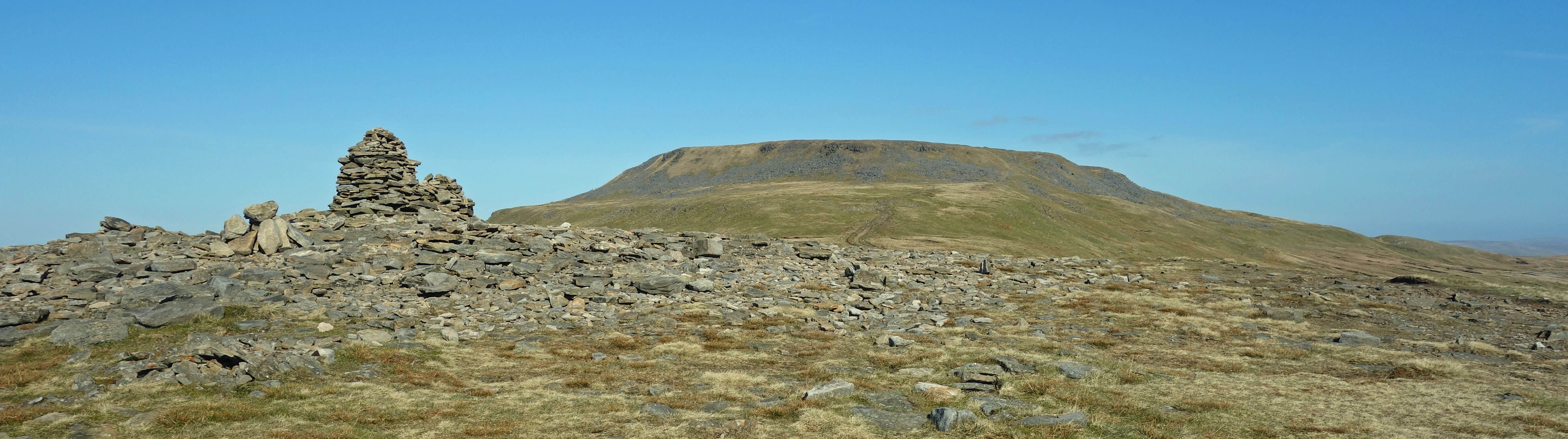
Little Ingleborough, with Ingleborough ahead
Unfortunately, I found that my hill-walking fitness, such as I had, had evaporated in the last 2˝ years
and the walk up Little Ingleborough proved a long slog for me. A snack revitalised me sufficiently to
manage the final 84 metres up to the top of Ingleborough (723 metres). I wandered around the summit plateau,
as you do, peering over the edges in all directions but although it was a sunny day with little breeze
there was too much haze for perfect long-distance views.
On this occasion, I took particular notice of
the great mound of stones on the south-west edge. This is due to an initiative by one Hornby Roughsedge
(great name!) (1786–1834 or so) of Bentham House. The story was told by Joseph Carr (1812–1899), a
historian of Bentham and Ingleton, in the Lancaster Guardian of May 15, 1897, describing events of 1830 (Carr, 1997). He wrote
“The Hospice Tower … was the proposed heading of the new building indicating that the erection was to be of general benefit to all tourists and the public generally who might ascend the venerable mountain. It was a matter which interested all the neighbouring villages, hamlets and even persons living in more distant towns … While some persons looked upon it as a wild goose chase, which was sure to prove a failure, others thought that a tower on Ingleborough would not only be an attraction to mountain climbers but a convenience in which they might rest and take their portable refreshments. Though the lords of the manor might use the Tower as a shooting box, still it was well understood that it would always be accessible to the public … When the building was near completion great preparations were made for its opening. The promoters of the Tower decided to make it a memorable event and a historical record.
The opening took place in the summer, and the day proved auspicious for the opening. People from every quarter of the compass were on their way from the two Benthams, Ingleton, and the neighbouring villages … The chief features of the day were feasting, racing, drinking, and at night drunkenness, and mischievous rowdiness. The tower was a circular and substantial building with a dome roof. A round stone table for refreshments was fixed to the centre. The door and windows were made of strong material on account of the terrible winds which sweep over the summits plain … To human appearance it looked as if it would resist the winter storms for ages with occasional repairing. The memorable event took place with great rejoicing and much shouting.
Mr Roughsedge and friends left for home some time before the drunken rows began and the work of mischief was completed. Thus drink and rowdyism inflicted ruin and desecration on an ornamental and useful building which had been put up at great expense and much labour … The great mischief done at the close of the memorable gala so grieved and annoyed Mr Roughsedge and the friends … that they would undertake no repairs, so that in the course of a few years it became a mass of ruins … The ruins lie in a heap near the south-west of the mountains edge and within sight of all the villages and towns westward as far as Lancaster and Morecambe as a monument of the sad effects of intoxicating drinks.”
With that sobering thought … (Actually, my thought (which perhaps I shouldn't express)
is that we should raise a glass to the drunken revellers. The top of Ingleborough is no place for a rich man’s folly. A tower there would ruin the natural, noble profile of Ingleborough, the most iconic image of the Yorkshire Dales.) … I walked down the path that leads to Ingleton but soon left it to search for purple saxifrage.
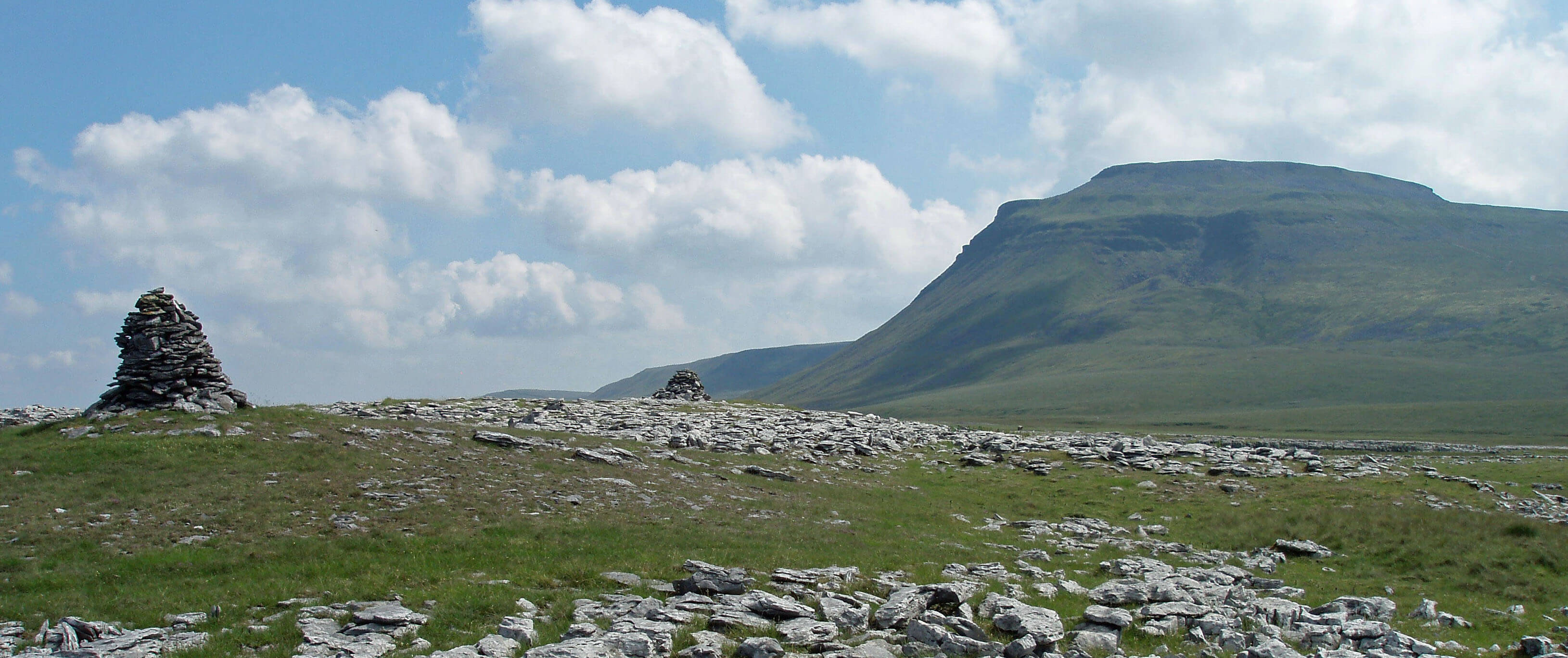
Ingleborough, without its tower (photo taken on a previous occasion)
 Purple saxifrage is an Arctic-Alpine plant. It flowers higher (at 4,505 metres) and at a more northerly point (at 83°N) than any other plant. It flowers earlier than other mountain plants, often poking through snow, and is therefore a welcome sign of spring to those living at high altitudes and northerly latitudes – and to me. On Ingleborough it is a remnant of the immediate post Ice Age period and survives only on cliff faces out of reach of sheep’s mouths and walkers’ boots. It also occurs on Pen-y-ghent and, I expect, on some Cumbrian mountains.
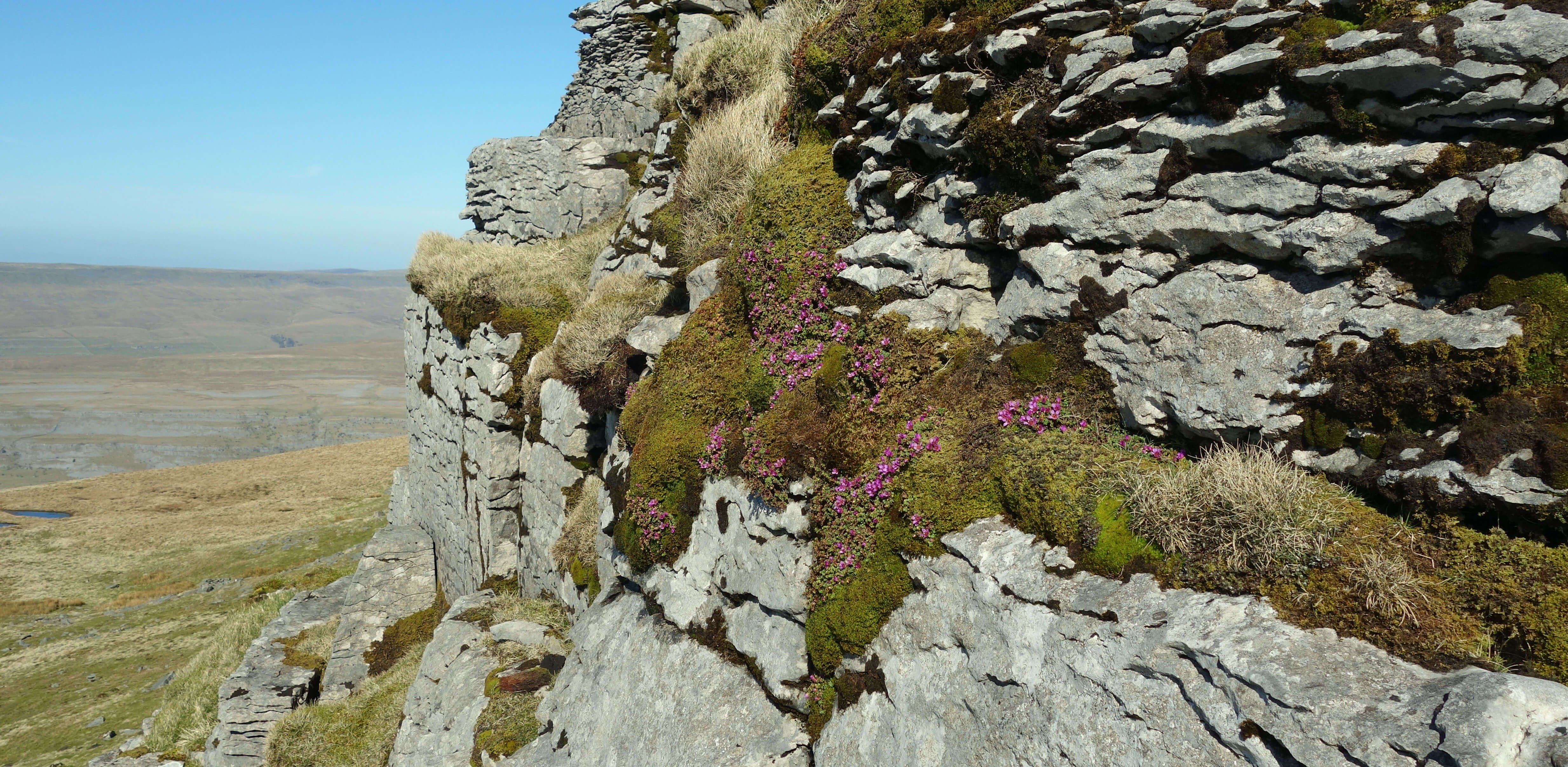
Ingleborough’s purple saxifrage may be found to the west and north-west of the top of Ingleborough on
the vertical scars of limestone at about 600 metres, above the huge ancient landslip and the precipitous slopes
of Black Shiver. The purple saxifrage occurs as a tight-knit, deep green plant, wedged into cliff crevices.
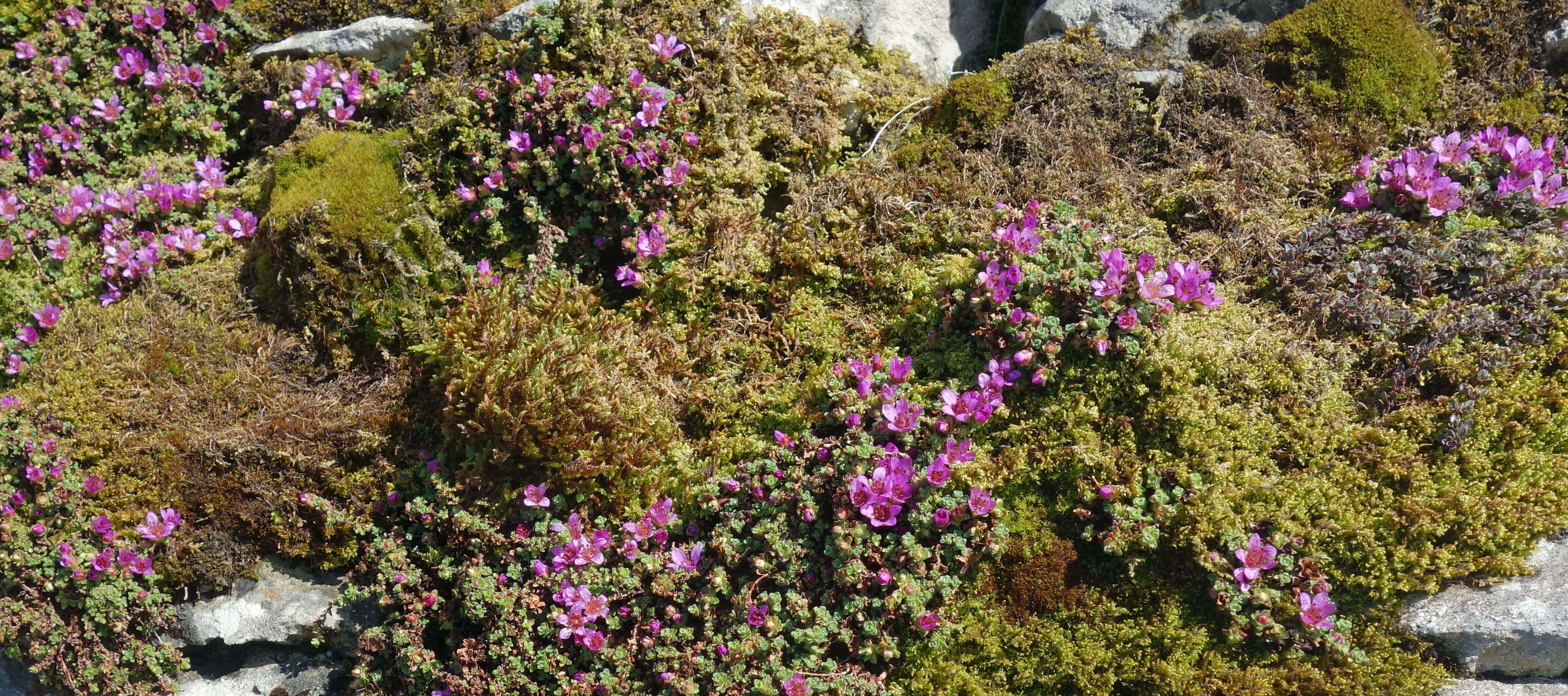
It is described in Mountain Flowers (Raven and Walters, 1956) as “the most spectacular element in the flora of the upper parts of Ingleborough”. The clusters of small purple flowers stand out among the greys and greens of the rocks and grasses, with the delicate purple-pink petals enclosing a ring of red-orange anthers. And yes, some of the purple saxifrage was in flower, which cheered me greatly.
The small cliffs have grassy ledges between them, which it is possible to contour along, with
care, and upon which it is possible to sit in secret isolation surveying lower Chapel-le-Dale, with the extensive limestone terraces of White Scars and Twisleton Scars stretched out below. It is a separate world here, with the purple saxifrage reassuring us that nature carries on regardless. Well, perhaps not quite regardless. I found only half-a-dozen patches of purple saxifrage (although I didn’t contour far around and there may be more above Black Shiver) and despite my elation there is still the nagging thought that climate change may be eliminating the purple saxifrage from Ingleborough.
Below: Purple saxifrage on Ingleborough; Above right: Purple saxifrage in location on the limestone cliffs.
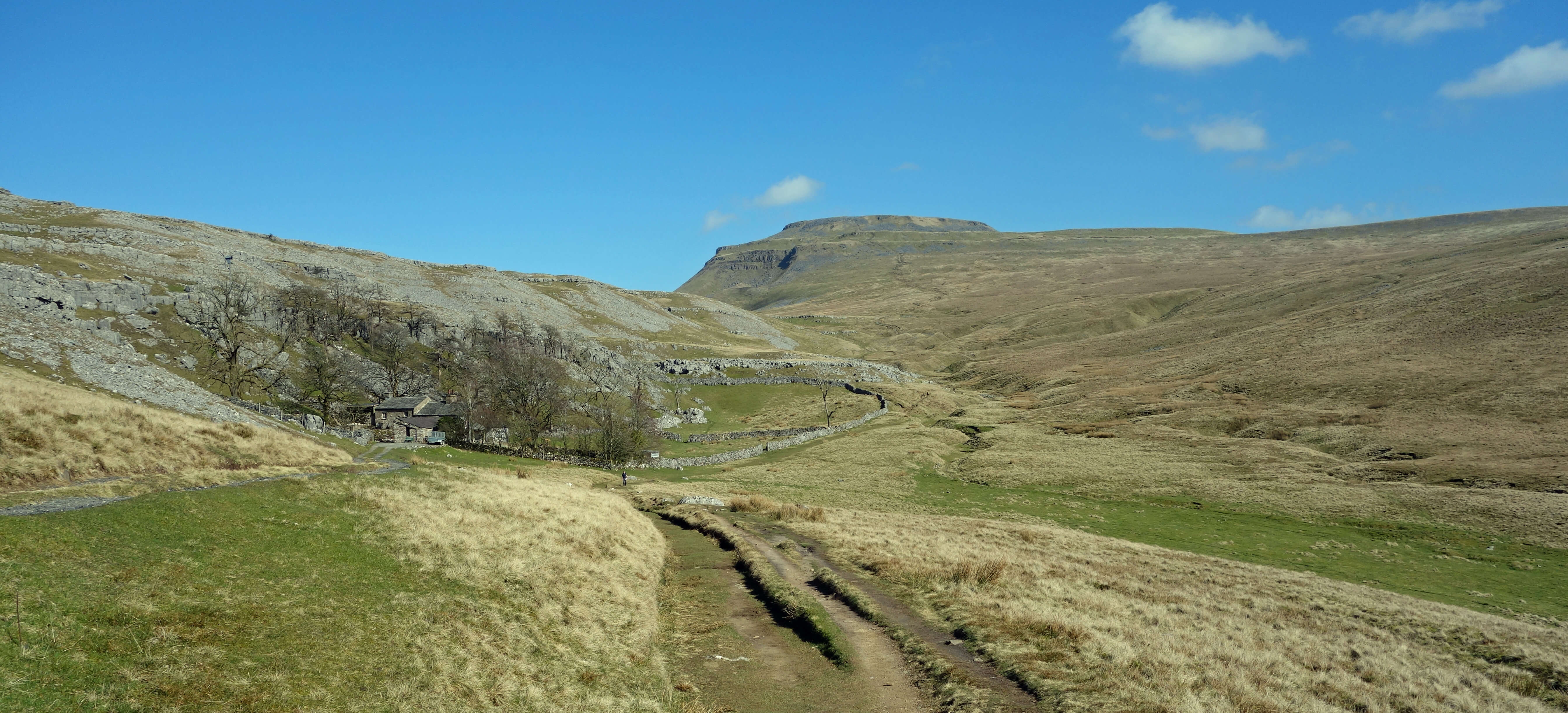
Crina Bottom and Ingleborough
Date: March 18th 2022
Start: SD725699, Newby bus stop (Map: OL2)
Route: (linear) NE through Newby, N – Newby Cote – N, E – Hagg lime kilns – NW
across Hagg, N over Newby Moss – Little Ingleborough, Ingleborough – SW, contour above Black Shiver and
back, SW, W – Ingleton
Distance: 8 miles; Ascent: 565 metres
Home
Preamble
Index
Areas
Dales
Hills
Lakes
Places
Reserves
Rivers
Structures
Villages
References
Me
© John Self, 2018-

Top photo: The western Howgills from Dillicar;
Bottom photo: Blencathra from Great Mell Fell