
Home
Preamble
Index
Areas
Dales
Hills
Lakes
Places
Reserves
Rivers
Structures
Villages
References
Me
Saunterings: Walking in North-West England
Saunterings is a set of reflections based upon walks around the counties of Cumbria, Lancashire and
North Yorkshire in North-West England
(as defined in the Preamble).
Here is a list of all Saunterings so far.
Guaranteed ad-free, AI-free and free!
262. West Blackburn: Reserves, Parks and Masjid E Vali
The borough of Blackburn-with-Darwen has four Local Nature Reserves (LNRs),
which is proportionally more than the county of Cumbria, which has ten. I
set out to see two of Blackburn’s four, but I didn’t expect them to be the
highlight of this walk.
The train journey between the once-industrial towns of Preston and
Blackburn may be a surprise to some. Once past Bamber Bridge the train
glides through typical English green pastures, of sheep, cattle and golfers.
I got off at Pleasington, where the 'Pleas' seems to be pronounced more
like the beginning of 'pleasant' than 'pleasing'.
It certainly seemed a pleasing village (what I saw of it) with stately
mansions, mature trees and, I expect, mature people (I only saw two,
walking their dogs).
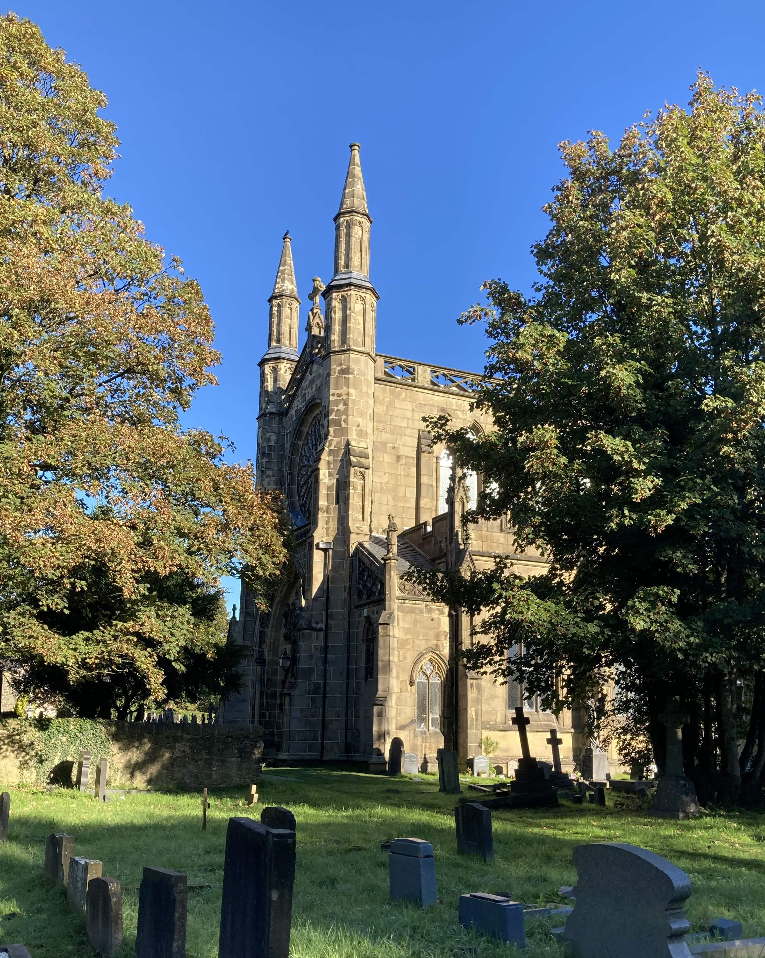 I paused at
Pleasington Priory
(shown right). This is an unlikely edifice
to find it such a location. It was built to a rather excessive scale in
the early 19th century on the initiative of a local dignitary, John Butler,
after he had a near-fatal accident at this spot. It seems that the builder
incorporated within the Priory every form of architecture from Early
English to Regency Gothic. It was locked, so I couldn’t inspect his
handiwork. Today the Priory is one of only two Grade I listed buildings
in the borough.
I headed for Pleasington Old Hall, which is marked on the OS map
in the font indicating antiquity. However, it was rather tree-shrouded
and I was so focussed on not losing my way that I didn’t notice it. I
didn’t see any sign of the Pleasington Old Hall Woods LNR either. This
didn’t surprise me. I assume that the LNR is within the out-of-bounds
woods-plus-pond nearby.
The fact that Blackburn-with-Darwen has proportionally more LNRs
than Cumbria does not mean that the former has more local nature worth
reserving than the latter. Cumbria has 2 National Parks, 3 National
Landscapes, 26 National Nature Reserves and 31 Special Areas of
Conservation, leaving little that could be an LNR.
Blackburn-with-Darwen has none of them, leaving the LNR designation as the last resort to
provide a degree of recognition and protection of its nature. An LNR may
be protected by the local plan of its authority but there is no national
legal protection specifically for LNRs and there is no legal necessity
for an authority to manage an LNR to any set standard. And there is
no necessary right of access.
I crossed fields to join the excitingly-named
Witton Weavers Way.
The name for this 32-mile trail is a result of democracy in action – the
council organised a vote. The name honours the local textiles history.
The Way consists of four circular trails: the Beamers, Reelers, Tacklers
and Warpers Trails. Checking later, I think I was with the Beamers.
The Way headed towards Billinge Hill but wisely headed south
before reaching it. Half-way along there was a toposcope with an image
of Alfred Wainwright, renowned guide-book writer, born in Blackburn where
he lived for the first 34 years of his life. The sign optimistically
pointed out some of the Lakeland fells that he walked upon (I couldn’t
see any of them). As far as I know, Wainwright never wrote about walking
up Billinge Hill.
Billinge Hill is covered by woodland, with many paths within.
The one I chose turned out not to take me to the top (245 metres) but
skirted around the northern flanks. I didn’t mind. It was a quiet, agreeable wood and, although the OS map marks a viewpoint, I was doubtful that there is much of a view through the trees (the fact that the toposcope isn’t at the top suggests so). I can live without finding out.


Left: The Wainwright toposcope; Right: Billinge Hill wood.
Once out of the wood, I headed for Masjid E Vali, which was the main
objective for my outing. This mosque opened in January 2026 and is
surely one of the most impressive new buildings in the region. It was
paid for by the Blackburn-born billionaires, Zuber and Mohsin Issa, who
became rich by transforming petrol stations into more than petrol stations.
They acquired Asda in 2010. The mosque is named after their father, Vali Issa.
The building has traditional mosque components of a central
dome, minarets and archways, with internal musalla (prayer hall) and
qibla wall facing the direction of Mecca. I had no intention of intruding into
this place of worship (it looked closed anyway) but there are videos on-line
(for example, this one)
that tour its large prayer halls, with ornate chandeliers, a courtyard
with fountains, and walls with calligraphic decorations. The building is
intended to serve as a community centre as well as a mosque.

Masjid E Vali
Everyone agrees that the building is impressive but can we say what is
impressive about it? I am always impressed by the technical knowledge
and skill necessary to create any such structure, including, for example,
our cathedrals. The building itself is not quite as imposing
as I had pictured. I imagined that the minarets and dome would rather
dominate the surroundings. In fact, the mosque is on a not very prominent
site within a residential area of other fine buildings and seems not
out of place at all.
I am, as always with any place of worship (not just mosques),
puzzled by the necessity to surround the act of worship with such grandeur.
I expect that the bright, majestic surroundings induce
a serenity conducive to worship but does such opulence
lead to deeper, more meaningful prayers? My own devotion is
so lacking that I would be distracted by
such splendiferous architecture. And if I were prayed to (which is unlikely) then I think I'd
respond more to those without a display of ostentatious wealth.
Anyway, my views are irrelevant.
The Issa brothers can clearly afford it and, no doubt, the worshippers are very grateful.
Incidentally, I notice that the
Wikipedia page on Blackburn
gives details of the ethnicity of residents: in 1981 it was 89% white, 10%
Asian or Asian British (mainly Indian and Pakistani) and in 2021 the
figures were 60% and 36%. This transformation is hardly reflected
in the surrounding text. The word ‘Muslim’ occurs just three times and ‘mosque’
not at all. Various landmarks are described (Cathedral, Town Hall, Corn
Exchange, Technical School, and so on). Somebody in the council should be
responsible for ensuring that descriptions of Blackburn are balanced and reflect the
fact that Muslims are indeed a significant part of the modern community. I’ll
be interested to see if Masjid E Vali gains a mention in Blackburn literature.
I walked along a lane to the Witton Country Park. The Witton estate
was created by the Feilden family and acquired by Blackburn Council in 1946.
The 480-acre park has adventure playgrounds, zip-wires, an animal centre,
crazy golf, café, and so on but seems mainly to be an area to stroll about green
fields and woodland. I don’t know that there is anything special about the
park but I am sure that it provides an enjoyable outing for local families.
Leaving the park, I had to walk along a short stretch of the Preston
Old Road to reach the Leeds-Liverpool Canal. The mile east on the tow-path
was along a peaceful oasis within a built-up area, leading me to Ewood Park,
which I was about to describe as the Mecca for Blackburn Rovers supporters,
but probably shouldn’t as Muslims might object. Anyway, it is less so
today than it was in 1995 when Rovers won the Premier League, the last
time that a team financed by a local person (Jack Walker) won it.

Leeds-Liverpool Canal
I walked down the Bolton Road (the A666), with noisy traffic non-stop in
both directions. Even the traffic lights were reluctant to stop it. I
stood by one for minutes, with a man nearby commenting “It’s mental, innit?”.
I thought it was me that was mental, walking along this road, in this
bedlam, with scruffy terraces one side and fenced-off industrial units
on the other, all the while heading in the opposite direction to my
intended destination, Blackburn Station.
I was determined to see my second LNR, the River Darwen Parkway.
This is described as a “rich mosaic of habitats” and I am sure some wildlife
appreciates it, which is the main thing. For me, though, it was a
straightforward walk on a paved path through woodland and Himalayan balsam,
with no sight or sound of the River Darwen to the left. I saw
nothing of interest. By this stage, I was losing the will to walk.
However, I left the Parkway to tackle an exhilarating
challenge to get to the station. Traffic roars at pedestrians from all
directions. Under the grim, dark railway bridge I expected to encounter Hades.
I emerged relieved but unenthused by central Blackburn, and possibly as a
result thought that if there were a prize for the ugliest building
that confronts visitors arriving at a town’s railway station then the
structure here would be a candidate.
Remarkably, it hides from the visitor any view of
Blackburn Cathedral
immediately behind it. While some might think the cathedral is rather
grey and inelegant, a sight of it would at least indicate to visitors
that Blackburn is a proud, important town with history and standing.

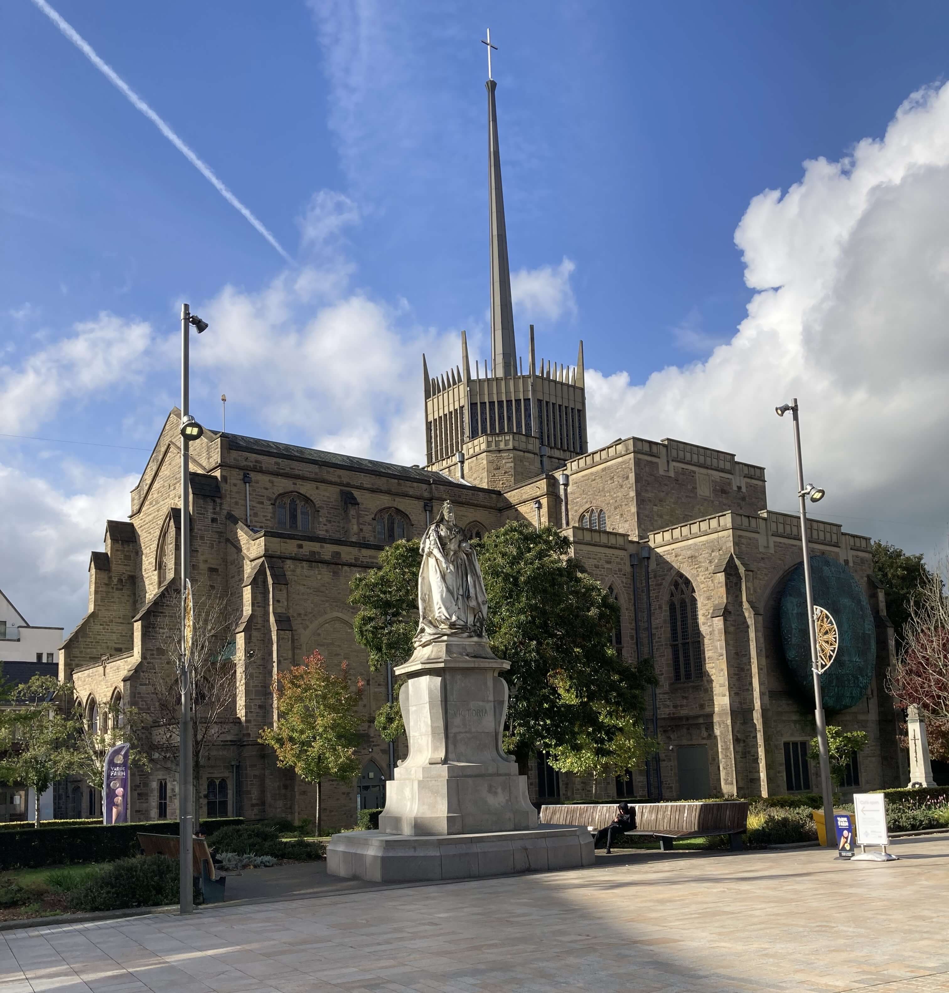
Left: The sight greeting arrivals at Blackburn Station; Right:
Blackburn Cathedral.
Date: October 8th 2026
Start: SD642262, Pleasington railway station (Map: 287)
Route: (linear) N through Pleasington, NE – Pleasington
Old Hall – N – Witton Weavers Way – NE, E by Billinge Hill – Masjid E
Vali – S, SW, SE through Witton Country Park – Preston Old Road – SW –
Leeds-Liverpool canal – E – Moorgate – S, E – Ewood Park – S on Bolton
Road, SE – bridge over River Darwen – NW through River Darwen Parkway –
A666 – NE – Blackburn station
Distance: 9 miles; Ascent: 200 metres
976 +452 /2400
Home
Preamble
Index
Areas
Dales
Hills
Lakes
Places
Reserves
Rivers
Structures
Villages
References
Me
© John Self, 2018-
Contact: johnselfdrakkar@gmail.com

Top photo: Rainbow over Kisdon in Swaledale;
Bottom photo: Ullswater