
Home
Preamble
Index
Areas
Dales
Hills
Lakes
Places
Reserves
Rivers
Structures
Villages
References
Me
Saunterings: Walking in North-West England
Saunterings is a set of reflections based upon walks around the counties of Cumbria, Lancashire and
North Yorkshire in North-West England
(as defined in the Preamble).
Here is a list of all Saunterings so far.
If you'd like to give a comment, correction or update (all are very welcome) or to
be notified by email when a new item is posted - please send an email to johnselfdrakkar@gmail.com.
77. Bridging the Lower Little Ribble
The Ribble is a modest river (the ‘little Ribble’) until it is joined by the Hodder and Calder tributaries below Great Mitton (to become the ‘big Ribble’). Above the confluence the Ribble is small enough to be relatively easily bridged and in the five miles to West Bradford it is crossed by four old road bridges, one footbridge and one aqueduct. The villagers of Great Mitton, Bashall Eaves, Waddington and West Bradford (on the west bank) and of Little Mitton, Whalley, Barrow and Clitheroe (on the east bank) must have been keen to mingle even though they were in the counties of Yorkshire and Lancashire, respectively. I went to wander along this pleasant stretch of the Ribble and to see one of the finest sequences of bridges in North-West England.
I set off south from Clitheroe on the Ribble Way and it was immediately apparent that the recent heavy rain
had overflowed the banks, promising me plenty of mud, with the Ribble itself still being the colour of it. Passing
the oddly-named Fishes and Peggy Hill Farm (is it one name or two?), I reached the first structure across the Ribble,
a rather functional aqueduct, part of the Haweswater-Manchester system. Beyond that, a steep river bank had become steeper
because of recent erosion. I then crossed the three-arched Mitton Bridge
that was probably built in the early 19th
century, replacing an old ferry crossing.
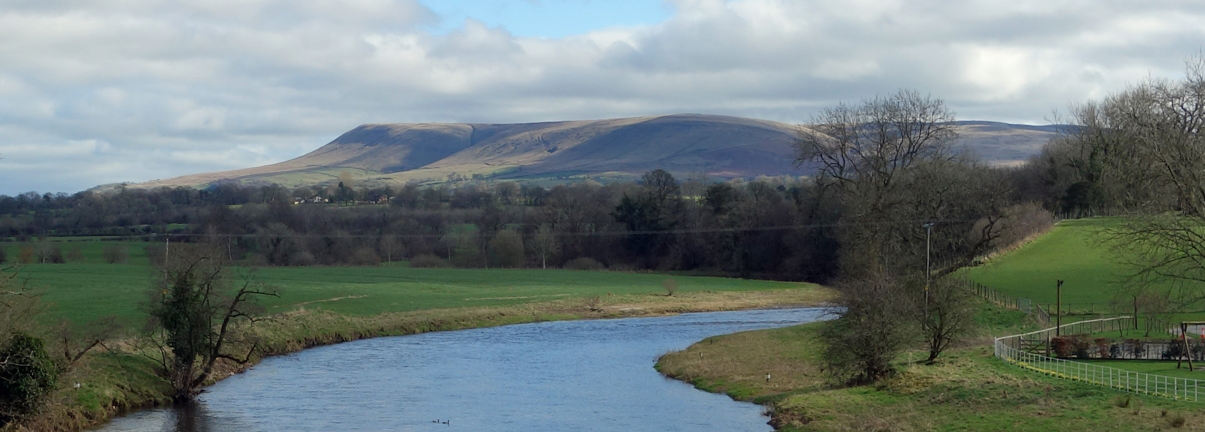
Pendle from Mitton Bridge
The village of Great Mitton is not that great, being only a handful of houses, but it boasts a hall with the
sign ‘Great Mitton Hall 1380’. I never know what to make of such dates. What can be seen of the present hall
is not of 1380 – unless its architect and builder were very far ahead of their time. Presumably, there is
evidence that the hall is on the site of a previous building of 1380 vintage, as a
Mitton family history
discusses, but then many present buildings must be on the site of older ones. The substantial adjacent
All Hallows Church is more genuinely ancient and is now a Grade 1 listed building.
The two-mile walk north from Mitton Bridge was a disappointing plod across sodden fields and along a busy road. It offered no view of my main focus for the walk, the River Ribble, although as some compensation there was a distant panorama of the south Bowland hills. I was led to contemplate the mud. Nowadays, our fields are waterlogged for several months. How did our ancestors cope, before the pastures were drained and without
our waterproof boots? They must have lived a life of wet, muddy feet.
I crossed a footbridge and walked through new houses and allotments and past a weir to
Brungerley Bridge. This impressive bridge was probably built in 1814 to replace one washed away in a flood.
According to legend, it was here in 1465 that Henry VI was captured, after staying at
Waddington Hall
whilst on the run after his Lancastrian forces had lost to the Yorkists at the Battle of Hexham.
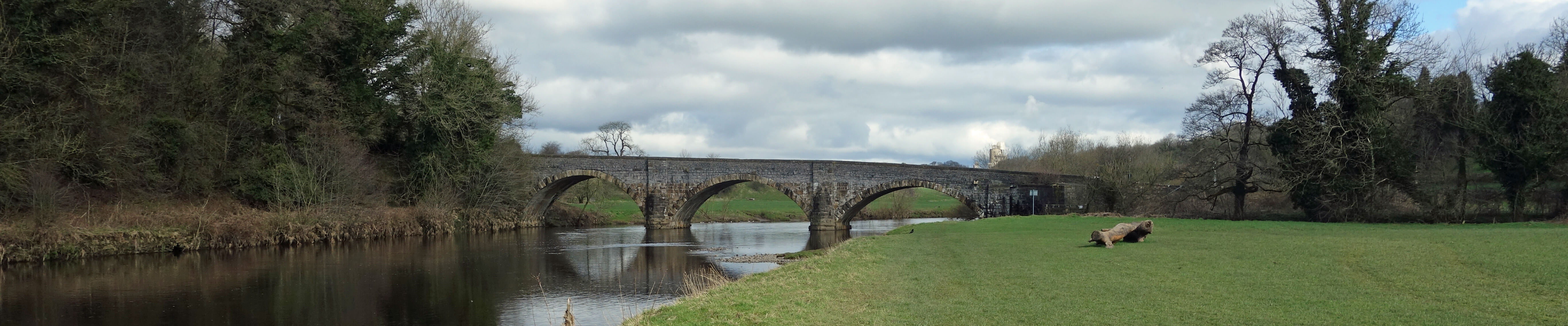
Brungerley Bridge
The walk north from Brungerley provided a magnificent view of the western slopes of Pendle above the buildings and chimneys of the Clitheroe cement works. A majestic white plume of smoke ascended vertically from the tallest chimney before spreading out to produce a cloud indistinguishable from real ones. And the noise of the cement works rather overcame the tranquillity of the banks of the Ribble.
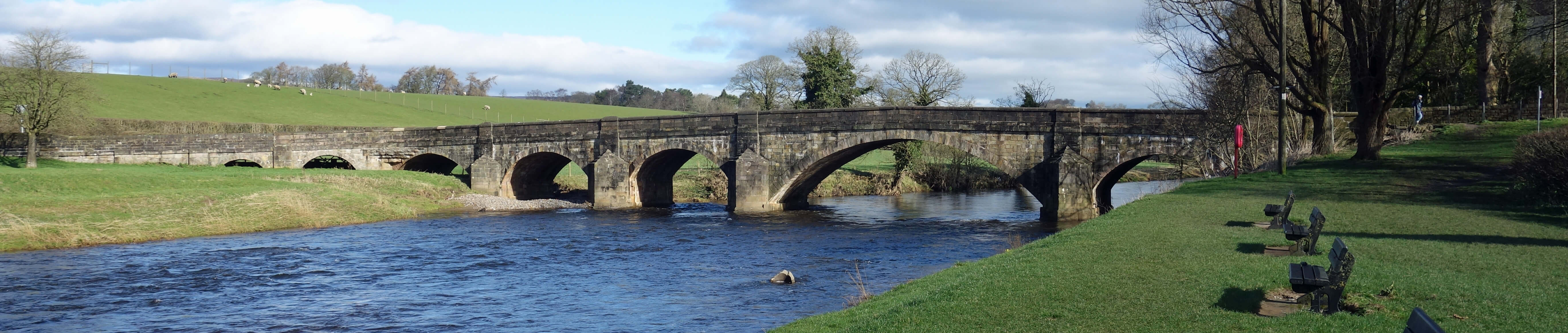
It seems that the four-arched, late 19th century
Bradford Bridge
is too narrow for modern traffic, resulting in frequent damage to its parapets. On this occasion there was more damage apparent to the road-side wall to the north, which had been demolished by recent floods.
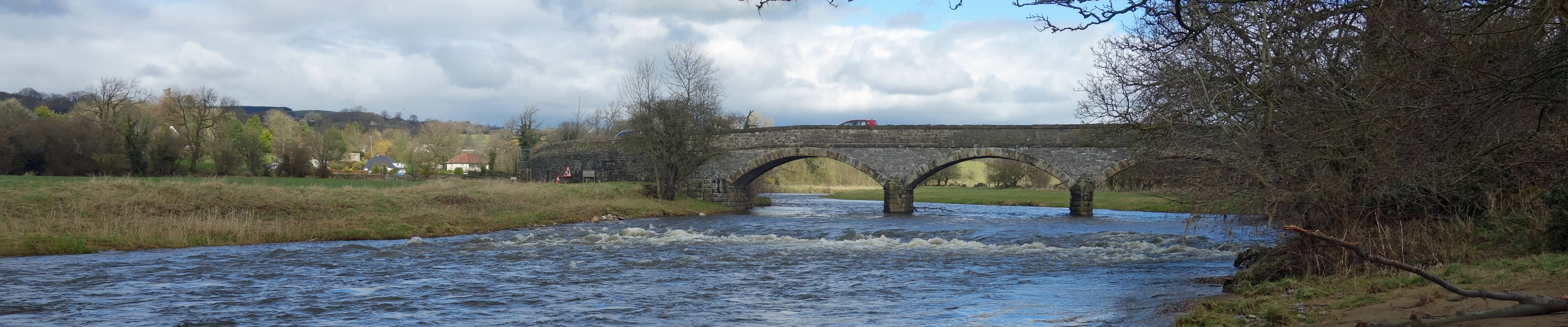
Bradford Bridge
The return walk on the opposite banks of the Ribble took me through the Cross Hill Nature Reserve, with Sculpture Trail, although I did not divert from the path to investigate either, and then past Waddow Hall. This hall had looked an imposing shiny-white building from the opposite bank but the walk beside it did not provide a closer view – which was perhaps as well as some pile-driver was in action, creating a racket. The hall is owned by the Girl Guides Association. According to Wikipedia, “even when most Scout organisations became mixed sex, Guiding remained separate in most countries to provide a female-centred programme”. I dare not comment – except to wonder whether our charities should accumulate funds sufficient to run such mansions.
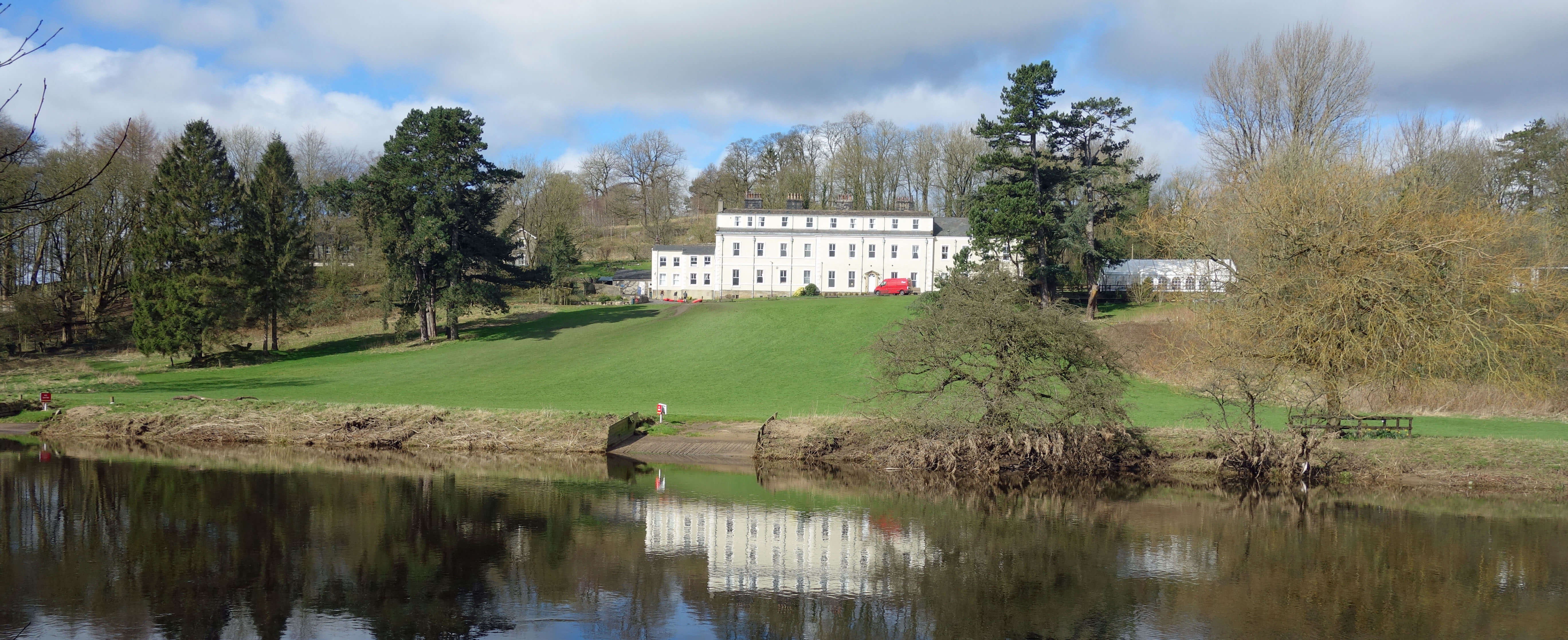
Wallow Hall, as it had been seen from the other side of the river
I passed Shireburne Park, a residential and holiday park. I’m sure the illustrious
Shireburn family
would be honoured that their name is so remembered. The Shireburns held the Stoneyhurst estate five miles to the west and have effigy graves in the Shireburn Chapel at the All Hallows Church of Great Mitton passed earlier.
Next I noticed a place that said it was the home of Atomstone Bulldogs. I always like to learn something new on my outings – and I have learned that Atomstone Bulldogs are the ugliest of dogs and that’s saying something. I concede that ugliness is in the eye of the beholder.
I had skirted by
Edisford (or Eadsford) Bridge
twice before on this walk but I’d left its appraisal until the end as it is the best of the four road bridges. It was built in the 14th century and has been widened for modern traffic. It has nine arches, the middle one over the river being much larger than the rest and possibly formed by reconstructing two smaller arches. Some of the arches are now partially buried by land, suggesting that the Ribble was once much wider than it is now. It was wider a few days ago.
Edisford Bridge
Date: March 13th 2020
Start: SD728414, Edisford Bridge, Clitheroe (Map: OL41)
Route: S on Ribble Way – Fishes and Peggy Hill, Mitton Bridge – NW –
Great Mitton – N – Brick House Farm, Edisford Hall – E, N, E over footbridge, NE on Ribble Way – Brungerley Bridge –
NW, N, NE – Bradford Bridge – S on Ribble Way – Brungerley Bridge – NW, SW past Waddow Hall, S –
Edisford Bridge
Distance: 9 miles; Ascent: 50 metres
Home
Preamble
Index
Areas
Dales
Hills
Lakes
Places
Reserves
Rivers
Structures
Villages
References
Me
© John Self, 2018-

Top photo: The western Howgills from Dillicar;
Bottom photo: Blencathra from Great Mell Fell