
Home
Preamble
Index
Areas
Dales
Hills
Lakes
Places
Reserves
Rivers
Structures
Villages
References
Me
Saunterings: Walking in North-West England
Saunterings is a set of reflections based upon walks around the counties of Cumbria, Lancashire and
North Yorkshire in North-West England
(as defined in the Preamble).
Here is a list of all Saunterings so far.
If you'd like to give a comment, correction or update (all are very welcome) or to
be notified by email when a new item is posted - please send an email to johnselfdrakkar@gmail.com.
41. Safe in Littledale
 I recently came across a couple of online descriptions of winter expeditions in North-West England that have put my own ambitions in perspective. My aim of visiting areas of North-West England more-or-less at random has rather lapsed this winter. I have lacked the commitment to scrape the ice off the car, to get out early to reach distant parts, to make the most of the limited daylight hours, to walk in sleet, ice and cloud. Using a car demands a serious hike. So I’m trying to use public transport more, although that further limits the range and time available for my outings. The main factor, however, is that I value safety, perhaps more than in the past.
On this outing I walked from my home around what used to be a regular running route but which
I have not visited recently. I had no need of a map or any special equipment. Even if there was
snow and ice remaining on the hill-tops I was sure that I wouldn’t reach it. I walked in daylight,
obviously – but there are those who seek the extra challenge of night walking.
The
first of the on-line descriptions
(note added much later: this appears to be no longer on-line, alas)
to which I referred concerned the ‘Hill Explorer’ walking around the Yorkshire Three Peaks (Whernside,
Ingleborough and Pen-y-ghent) on a January night. He asked for volunteers to accompany him but only
one young woman, whom he didn’t know, did so.
They completed the 24-mile walk in a bit over the 12
hours allowed for the
Three Peaks Challenge
but they must be disqualified anyway for failing to find the Ingleborough trig point in the dark (rules is rules). They discovered “just how much harder it is to navigate at night”. Well I never. And – surprise, surprise – they had some difficulty walking on ice in the dark. Accidents are liable to happen at any time: we don’t have to provoke them.
Luckily, they had no accidents but what if they had?
I walked into Littledale, which is a little dale tucked between Caton Moor and the slopes that
lead up to Ward’s Stone, the highest point of the Forest of Bowland. It is always a peaceful dale with
very rarely anybody to be seen. I saw little wildlife either but I did notice one pioneering lapwing
that had come early up to the fells, practising his flights of fancy in the sun after the recent snow,
but I fear that he may suffer from premature elevation. There were still a few streaks of snow left
on the Bowland hills.
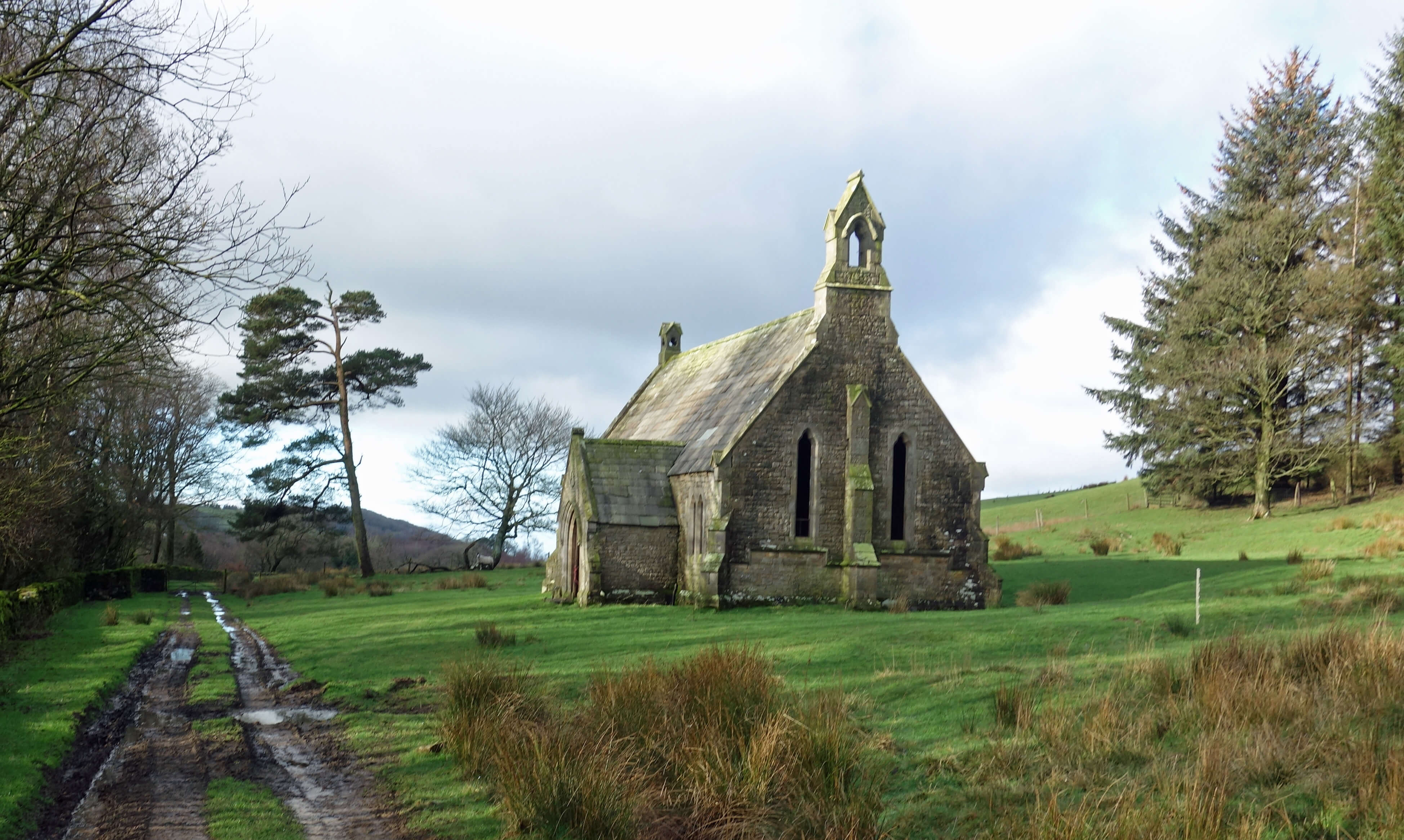
The footpath from the small hamlet of Crossgill, which eventually leads into Roeburndale, passes
through woodland and
by the isolated old Littledale Chapel (shown above right), now used as a barn. It was built in 1849, along with
Littedale Hall, for the Reverend John Dodson as a 'free church', as it says above the door.
It was supposed to be free, the Rev. Dodson hoped, from political inference.
It must have been free of a congregation too, as the nearby Crossgill already had a St Anne's Chapel.
The path continues above Littledale Hall and through sheep fields, one of which was
thoroughly studded with fresh molehills. Are moles especially active after a spell of frozen ground?
Upper Roeburndale
The Littledale path does not venture onto the rough, craggy, heathery, millstone grit moors of Bowland –
unlike the path that was tackled in the second of the descriptions I mentioned.
This video
by ‘Lancashire Wanderer’ says that it’s about a walk from Hareden to Totridge and
Bleadale Water and back by Langden Brook. The actual walk shown is the other way about – it begins by
Langden Brook. If that is not disconcerting enough, my
alarm bells began ringing when they missed the first path off (the one south to Bleadale Water) and then
proceeded to have a prolonged brew by Langden Castle, which is actually a barn. It’s only half-an-hour’s stroll to the barn. They
shouldn’t have needed a tea break yet. They needed to get a move on because the walk they had in mind
is quite a challenge, as is clear from the map even if you’ve never been there before. Later, it became obvious (to me but apparently not to them) that, judging from where the sun is at 18 minutes into the video, they would not get round the planned route in daylight.
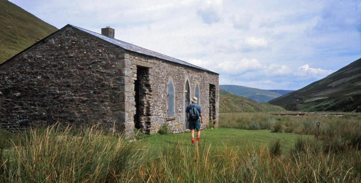 Left: Langden Castle (photo taken on a different walk).
They amble on, fall in the beck, slide down a bank, and duly get lost.
By 23 minutes they are in the dark. “It went dark” laments the leader, nonplussed by the inconsiderateness of it. He decides
that they must walk ‘as the crow flies’ to get back to the car. As the crow flies, in the dark, over
Bowland hills! By 26 minutes two of the party have been abandoned, one of them injured. From a spasm of
self-awareness, we hear “stupid, this”.
Some hours later, the benighted couple are retrieved by Mountain Rescue,
with four police cars and two ambulances assisting. They were very fortunate that (as the leader was clearly unaware) the Bowland Pennine Mountain
Rescue team is based at Smelt Mill Cottages, right by where they had parked. Afterwards, the leader
had the gall to comment that Mountain Rescue were “singing my praises” because he could give them the
GPS coordinates for where the couple were. That was the only sensible thing he did in the whole
expedition! Why do people post such videos on-line? Do they not realise how irresponsible and
incompetent they are? Are they proud of such escapades? Or are they intending to warn others?
I walked past the isolated farm of Deep Clough and one-by-one the Three Peaks appeared
ahead of me, Pen-y-ghent, Ingleborough and then Whernside, the last the snowiest of the three,
as befits the highest. I could see them all, perfectly arrayed, and much else besides, which
is more than could be said for our Three Peaks night walkers. The woman commented that with
night walking “you become one with nature … you’re much more in touch with everything you pass
by”. That’s what all ‘adventurers’ say. The sentiment is contradicted by her own words – she
mentions absolutely nothing of whatever it was she felt ‘much more in touch with’. But then,
as her companion said, “we arrived at the [Ribblehead] Viaduct, which is normally an amazing
sight but on this occasion quite invisible!” If you can pass by the Viaduct and be unaware of
it, what exactly did she pass
by and feel at one with?
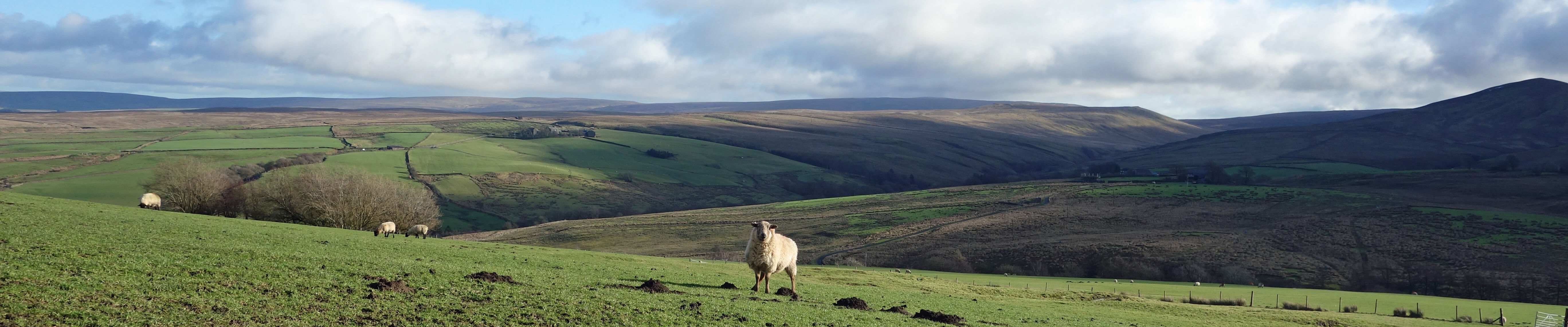
Whernside, Ingleborough and Pen-y-ghent from the Caton Moor bridleway
Continuing on the bridleway over the crest of Caton Moor, I found the expanse of Morecambe Bay spread out
ahead, embraced within the promontories of Fleetwood and Barrow-in-Furness. From this perspective it
seems not surprising that tourists used to be ferried between the two. And then the Lake District hills,
from Black Combe to High Street, came into view, still impressively white, followed by the Howgills, at
the head of the Lune valley, and then our friends Whernside and Ingleborough re-emerged on the other
side of Caton Moor. From here it is a gentle cruise downhill with my home village visible ahead, nestled in the valley. It is a local walk but I don’t take it for granted. There really are remarkable views throughout. And there’s no risk involved. Those who need to endanger their own and other’s safety to gain the thrills they need should really adopt more suitable activities than walking.
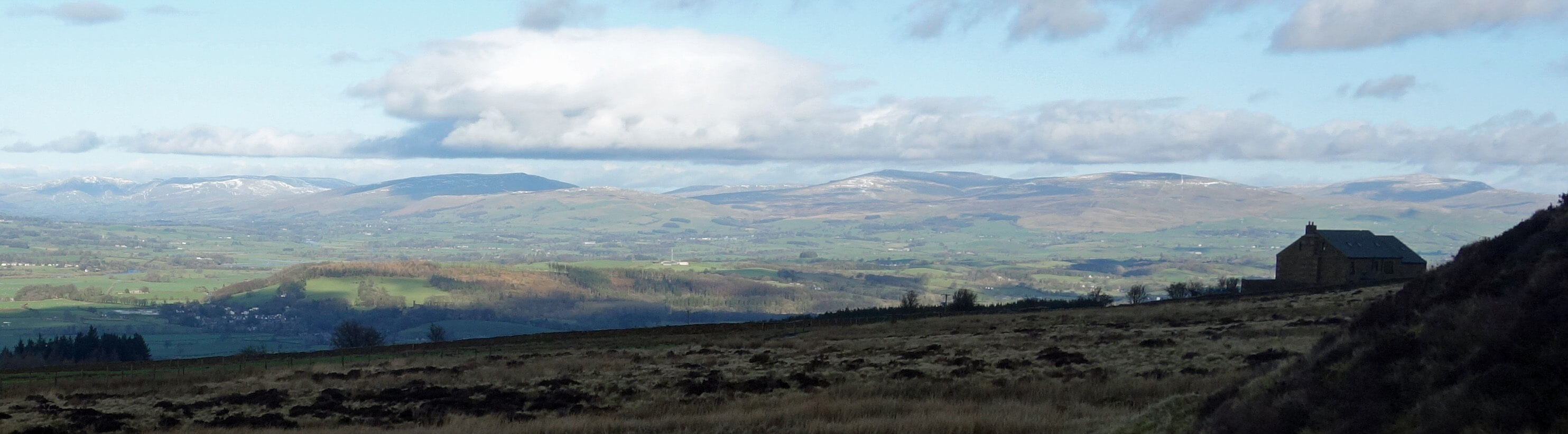
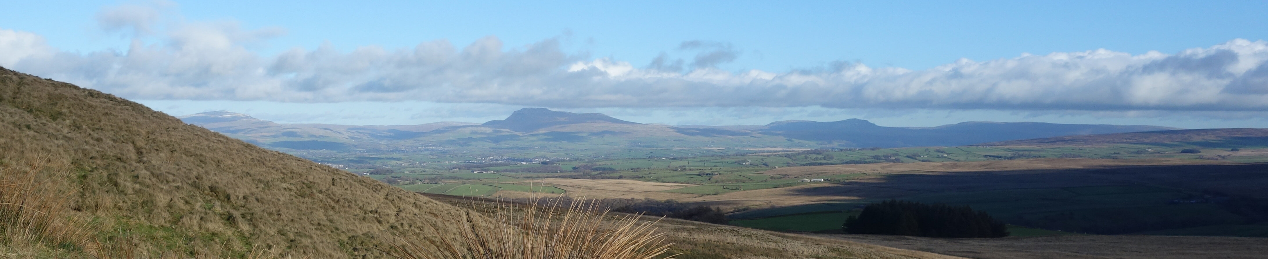
A distant view north from the other side of
Caton Moor of (from left to right) the Howgills, Barbon Fell, Gragareth and Whernside
Date: February 4th 2019
Start: SD543644, Brookhouse (Map: OL41)
Route: S, SE on Littledale Road, SE on track, E – Crossgill – E –
Deep Clough – E, NE – Roeburndale Road near Winder – W, N, NW on bridleway – picnic spot – W on Quarry Road - Brookhouse
Distance: 9 miles; Ascent: 280 metres
Home
Preamble
Index
Areas
Dales
Hills
Lakes
Places
Reserves
Rivers
Structures
Villages
References
Me
© John Self, 2018-

Top photo: The western Howgills from Dillicar;
Bottom photo: Blencathra from Great Mell Fell