Western Howgills

Home   Preamble   Index   Areas   Map   References   Me   Drakkar

Saunterings:  Walking in North-West England

Saunterings is a set of reflections based upon walks around the counties of Cumbria, Lancashire and North Yorkshire in North-West England (as defined in the Preamble). Here is a list of all Saunterings so far.
If you'd like to give a comment, correction or update (all are very welcome) or to be notified by email when a new item is posted - please send an email to johnselfdrakkar@gmail.com.

169.  A Quinquennial Ambulation over the Moor

As Saunterings is reaching the end of its fifth year I thought I’d celebrate and reflect by walking up Caton Moor as I did in January 2018 (in Sauntering 1). I could not, however, follow the same route because a permissive path that I had used then has reverted to being private. Instead, I aimed to walk up the lane and track direct to the top of Caton Moor and then continue over the moor to Hornby, returning by bus.

The sun had not yet risen over the moor as I set off but the northern side of the valley was in sunshine so I knew that it wouldn’t be long. The snow that had fallen nearly a week ago still lay upon the ground. It has been freezing ever since. The roads, however, were clear of snow and ice although they became less so the higher I walked. Fairly soon the Lake District hills came into view behind me and I was a little surprised that it was only the Coniston fells that seemed to have a good snow covering, although the other tops were somewhat hazy.
over lune valley

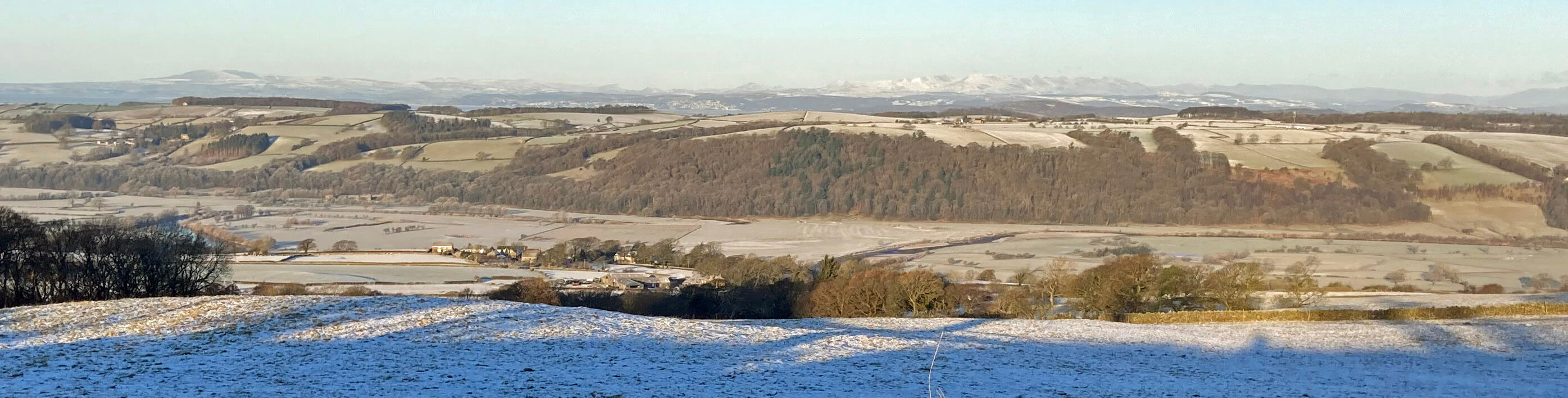
Over the Lune valley to the Lake District hills, Black Combe to the left and the white Coniston hills central

The sun was now upon me and, as there was no wind, it was really quite pleasant, although still bitterly cold. As I reached the cattle grids the views up the valley to the Dales hills opened out and again I was surprised at how selective the snowfall seemed to have been. Ingleborough was thoroughly white but the Howgills, Middleton Fell, Gragareth and even the higher Whernside seemed to have only a light topping.

highland cattle The road above the cattle grids, beyond the last farm, was quite slippery but it ended at the parking spot near the windmills, from where I continued up on the bridleway. The sun was directly ahead, sitting low on the hill-top, dazzling me. I walked on up and then, suddenly, I was confronted by a huge, dark shadow. And then several more. Some with long pointed horns. Yes, I had walked into a herd of Highland cattle. No doubt they are friendly but I had rather rudely barged in upon them. So I retreated sharpish.

Instead, I walked up on the other side of the wall, by the windmills, climbing the wall in the top corner of the field to rejoin the bridleway. I don’t like to climb walls but if someone puts Highland cattle in my way then I may be excused. I duly reached the Caton Moor trig point, where I did, of course, pause for a while. I will never fail to be impressed by the view ahead, of the afore-mentioned Dales hills plus now Pen-y-ghent and Fountains Fell. They are arrayed to perfection. And to the west there’s Morecambe Bay and the Lake District panorama, a little hazy, as I’ve said, on this occasion. Behind me, the detail of the Bowland hills of Ward’s Stone, Mallowdale Pike and so on could not be discerned because of the low sun behind them.
caton moor trig

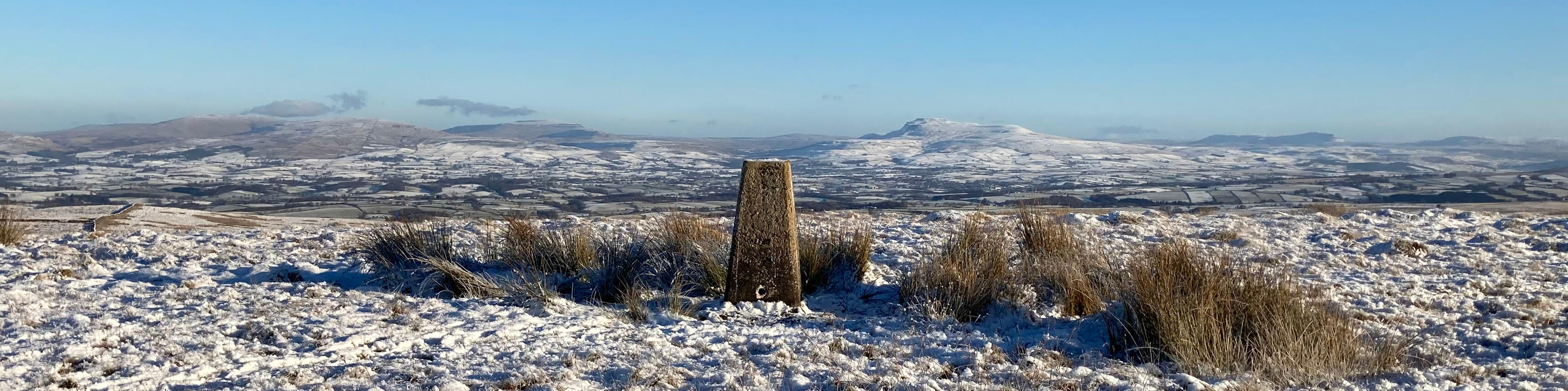
The Caton Moor trig point, with, from left to right, Gragareth, Whernside, Ingleborough and Pen-y-ghent

I continued north-west across Whit Moor, tramping through the sparkling snow, following a sort of path that had been beaten for me by a few people who had already walked this way. While I enjoyed the Dales view ahead, I tried to reflect on the past and future of Saunterings.
caton moor

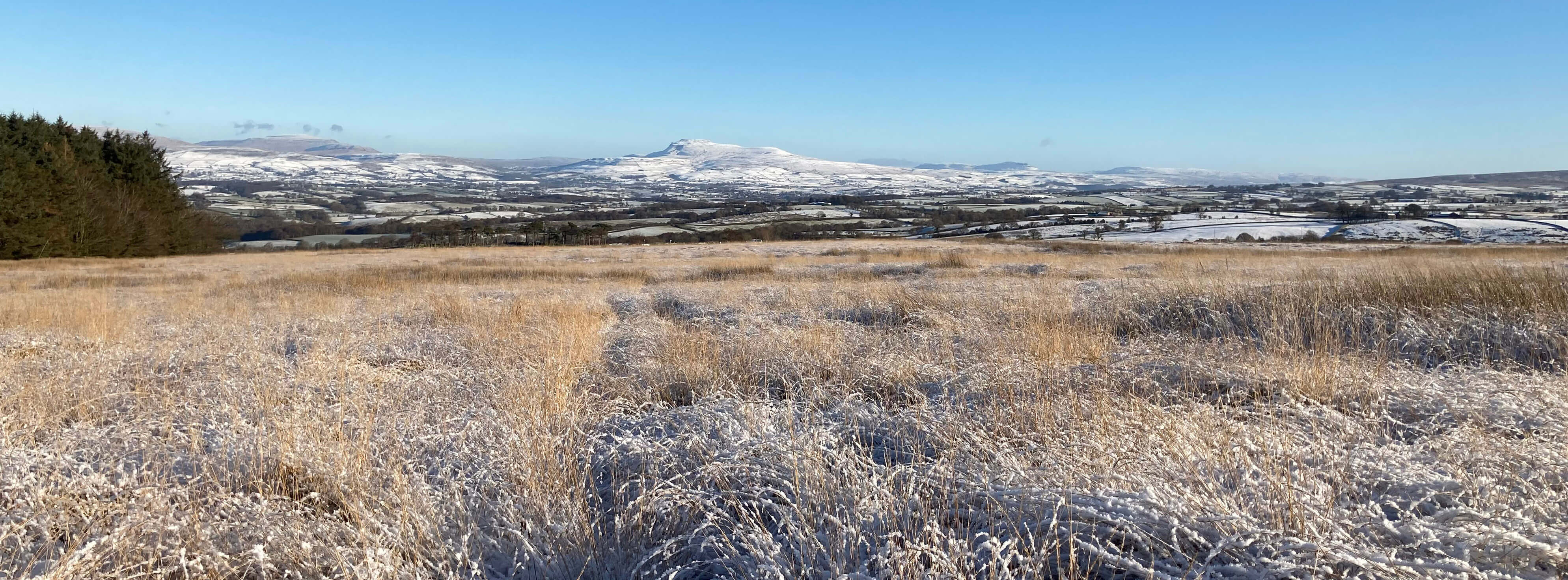
Walking down from Caton Moor with Whernside, Ingleborough and Pen-y-ghent ahead

But I didn’t really have any thoughts on this. I am content with the decisions made in 2018 and hope to carry on in much the same vein. I am glad not to have used a professional blog-hoster like WordPress, which, I imagine, entails hassle (and cost) and a loss of freedom to adapt as I wish. I probably expected to add more bells-and-whistles to these pages over time but I haven’t. After all, it’s just words and photos (and I’m including more photos now as many readers (or viewers) seem to like them). The only change to the structure of the web-pages has been to give each Sauntering a separate page to improve their ‘mobile-friendliness’, rather than lump them together in sets of ten as I used to.

I am content, too, with the style of Saunterings. It was never intended to be a catalogue of walk descriptions. Yes, I enjoy the walks (and who could ask for more than this, I thought, as I wandered down) but the aim was also to raise issues that may cause a reader to pause and ponder, as I do on my walks. The pandemic changed the nature of my outings, of course. I don’t drive off alone to walk as often now – only four times, and not far, in 2022, compared to over twenty times in 2018. Maybe I will regain a more venturesome spirit. I may also include some shorter walks too (not that my walks are long by serious walking standards) as I sense that readers like a mixture of long and short walks, some of which they might imagine doing.
caton moor

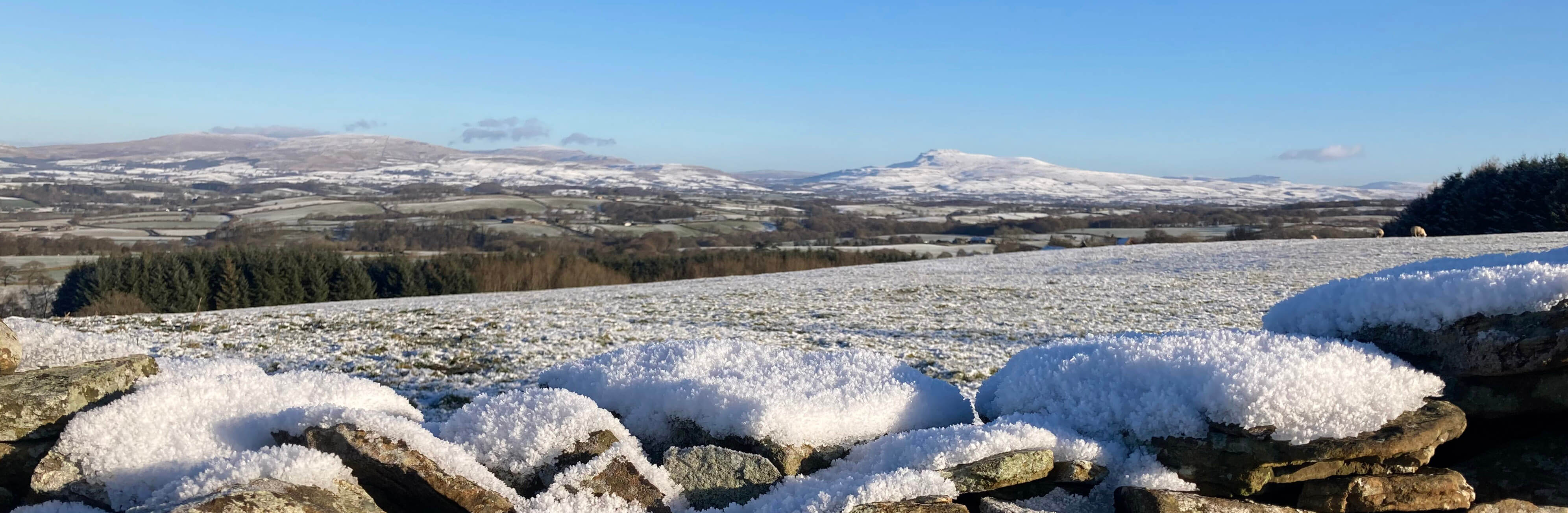
Another view of the Three Peaks of Whernside, Ingleborough and Pen-y-ghent, from Moor Lane, dropping down to Hornby

Returning to today’s walk, here’s something that may cause you to pause and ponder. Halfway down Moor Lane in a field to the left there’s recently been created a conglomeration of wooden structures. There are probably over a hundred of them. Some look like rough-and-ready sheds or enclosures or walls or posts or nothing much at all. They seemed rather jam-packed together and, as far as I could tell, higgledy-piggledy. There was no sign of any animals. I could make no sense of it. What do you think it’s all for?
skirmish site

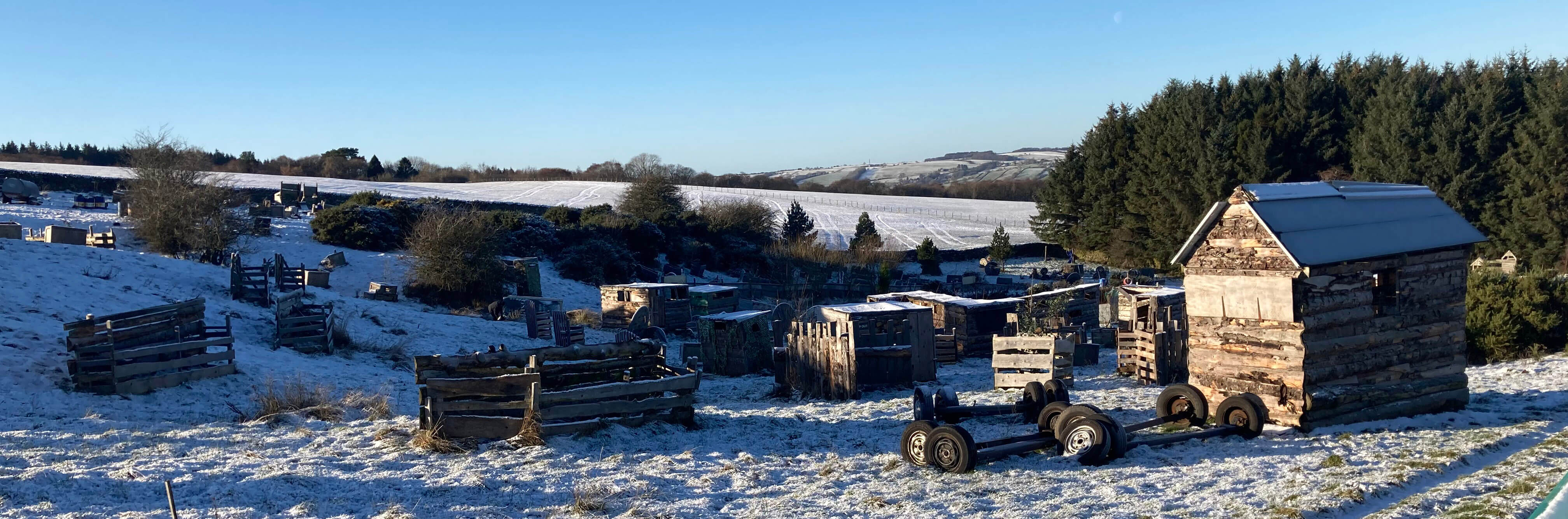
Part of the field of wooden structures off Moor Lane

I walked on into Hornby to wait for the bus – but it sailed past without stopping. That’s one of the problems with relying on public transport!  So I had longer to spend in Hornby than I expected. I didn’t mind. Hornby is an old village, mentioned in the Domesday Book and granted a market charter in 1292. The main street has a number of fine buildings, including St Margaret's Church, with its octagonal tower. I wandered about, viewing Hornby Castle from various angles and walking alongside the River Wenning, which was iced over above the weir. At the weir workmen were carrying out a survey – with one of them at one point walking out onto the middle of the weir, which with all the ice seemed a hazardous activity. I assume that they are planning to repair the part of the weir on the near side in the photo that seems to have broken off.
hornby castle

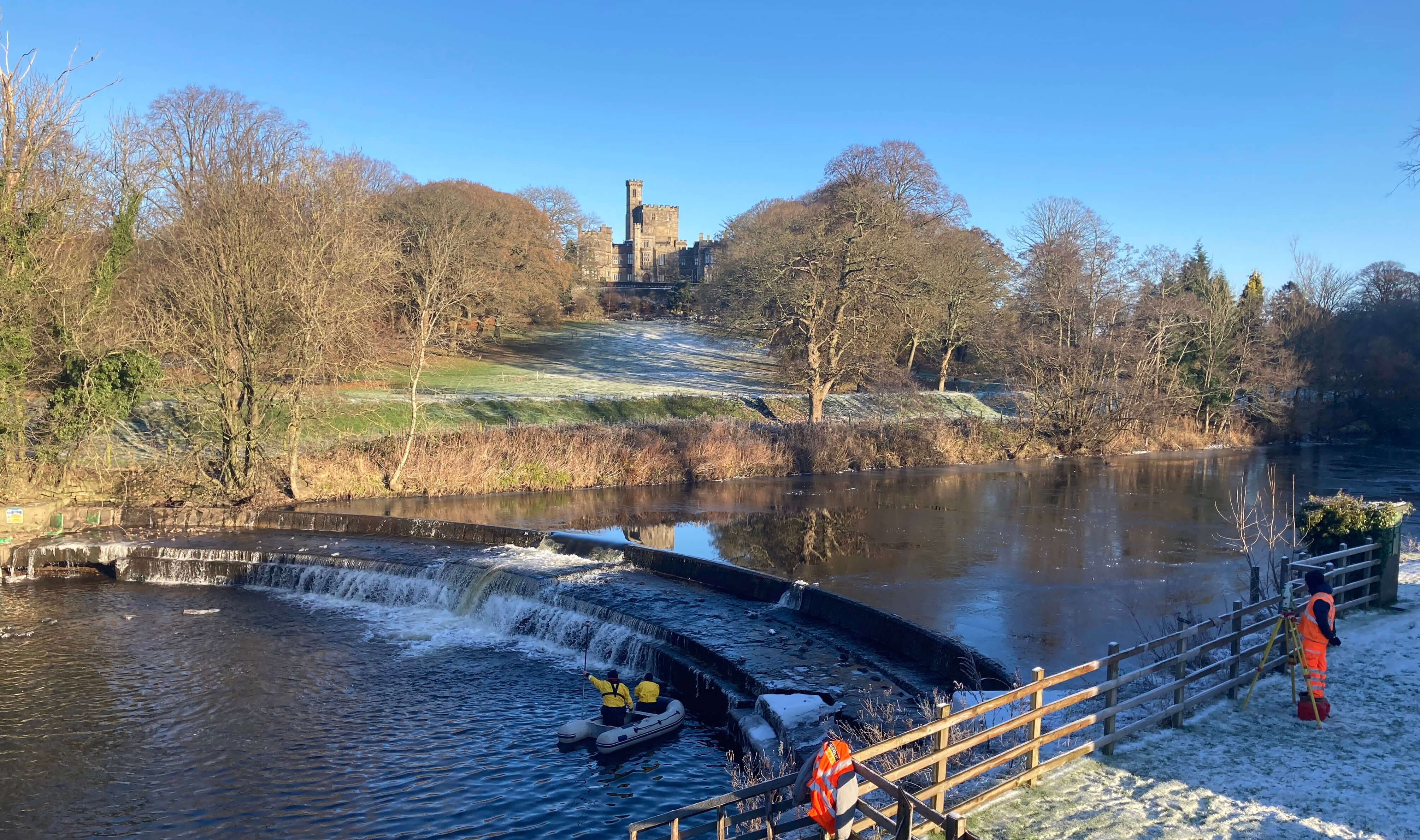
Hornby Castle, the River Wenning, the weir and the workmen

After the walk I searched on-line and found, I think, the answer to the Moor Lane puzzle. It’s a ‘skirmish site’. Which is a new concept to me. According to this website, “Moor Lane Airsoft is a live combat simulation experience day designed to replicate realistic combat simulation and the intense atmosphere of a real battlefield. Our authentic airsoft zone has a variety of both natural and manmade cover.” Airsoft is, apparently, "the UK's fastest growing combat sport". So, it’s to play soldiers.

    Date: December 14th 2022
    Start: SD543644, Brookhouse  (Map: OL41)
    Route: (linear) SE – Moorside Farm – E on Quarry Road – picnic site – SE on bridleway, NE – trig point – NE over Whit Moor – road – NW on Moor Lane – Hornby
    Distance: 7 miles;   Ascent: 300 metres

The two following items:
     171.   Along the Ribble Way to Brockholes
     170.   Nicky Nook and Landscape Art
The two preceding items:
     168.   To Lancashire’s Highest Point, Wherever It Is
     167.   Yealand Woods, Leighton Hall and the Pheasants
Two nearby items:
         1.   The Taming of Caton Moor
       90.   “One Form of Exercise – such as Walking” to the River
A list of all items so far:
               Saunterings

Home   Preamble   Index   Areas   Map   References   Me   Drakkar

    © John Self, Drakkar Press, 2018-

Blencathra

Top photo: The western Howgills from Dillicar; Bottom photo: Blencathra from Great Mell Fell