
Home
Preamble
Index
Areas
Dales
Hills
Lakes
Places
Reserves
Rivers
Structures
Villages
References
Me
Saunterings: Walking in North-West England
Saunterings is a set of reflections based upon walks around the counties of Cumbria, Lancashire and
North Yorkshire in North-West England
(as defined in the Preamble).
Here is a list of all Saunterings so far.
If you'd like to give a comment, correction or update (all are very welcome) or to
be notified by email when a new item is posted - please send an email to johnselfdrakkar@gmail.com.
229. One Good Tarn Deserves Another Three
My dictionary defines a tarn simply as “a small mountain lake”.
Both of those adjectives might be questioned with respect
to Burnmoor Tarn, visited in [228].
So, after missing Eel Tarn and Stony Tarn then, we thought we should see three more
of Eskdale’s tarns in order to get a better
idea of the concept of tarnality.
The fell north of Beckfoot looked steep and daunting, with no apparent
path through the rocky outcrops and the bracken. However, there was the beginning
of a path by the railway line at Beckfoot and it did indeed zigzag us up.
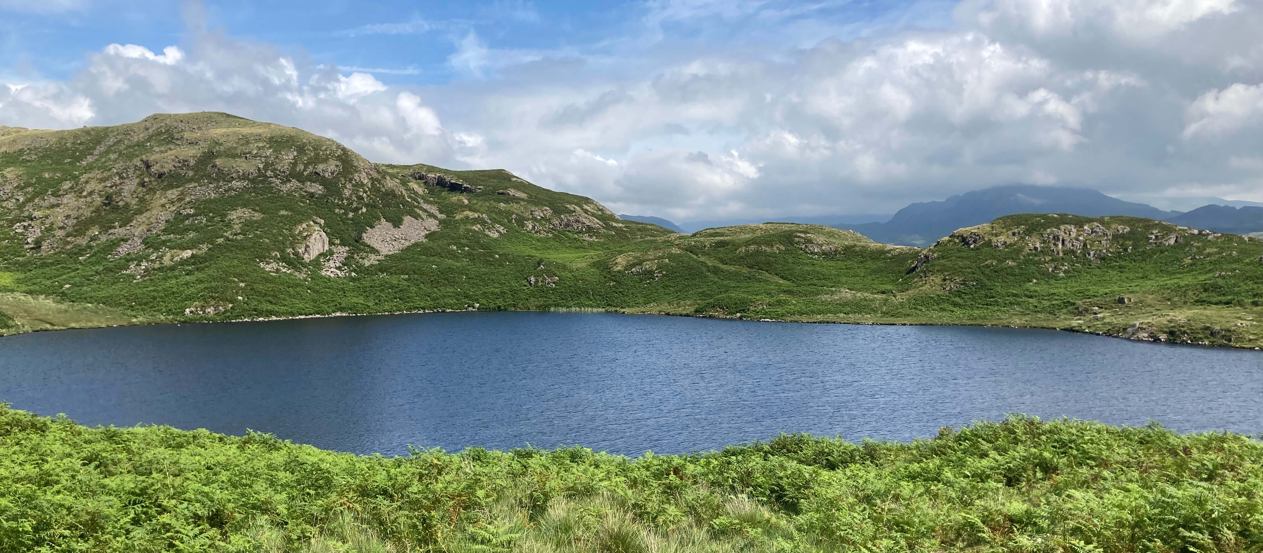
Eventually cresting the brow, we immediately had Blea Tarn revealed ahead of us.
This is one of three Blea Tarns in the Lake District and there is also a Blea Water,
which is a better tarn than any of them.

Blea Tarn (the outlet is in this left corner)
The Eskdale Blea Tarn adequately fits my image of a tarn. It lies in a basin surrounded by
the white granite Bleatarn Hill, except at its outlet at the south-west corner. It is of
a reasonable size, with a surface area of about eight acres, making it the 54th largest
body of water in the Lake District. It is a quiet haven where, unless you’ve brought
swimming or fishing gear, there is little to do but sit and admire the scene for a while.
Here we directed a group struggling to find our zigzag path down. It’s always good
to be asked the way because it suggests that we look like we know what we are doing.
We eventually walked on, heading for Blind Tarn and Siney Tarn. However,
we wandered too far west – but we returned to a vantage point from which we could see what we assumed
to be Blind Tarn and Siney Tarn and paused for a picnic with them in sight to ensure
that they didn’t escape us again.

Siney Tarn (in the middle) and Blind Tarn (to the right) from our picnic spot
We could be excused for missing Blind Tarn for it is little more than a puddle. The dictionary
says “small” and Blind Tarn certainly is. However, if we are going to dignify
such a body of water with the Tarn appellation then we must accept that there are
hundreds of similar puddles in the Lake District that deserve to be called Tarns too.
Perhaps some authoritarian should insist that all Tarns must be greater than some minimum size.
On the other hand, if a tarn has to be “small” then can a body of water be
too large to be called a Tarn? As we saw, Burnmoor Tarn is the largest natural
Tarn in the Lake District. In fact, if we exclude Seathwaite Tarn (which is a reservoir)
and Tarn Hows (which has been created from three smaller tarns) then Burnmoor Tarn is
twice as large as the next largest named tarn (Grisedale Tarn). The afore-mentioned
Blea Water, which is, everyone would agree, a tarn but not a Tarn, is three-quarters
the size of Burnmoor Tarn.
Burnmoor Tarn is larger than one of the sixteen lakes usually considered to
constitute the lakes of the Lake District (Elter Water). However, if we just took the
sixteen largest bodies of water to be the lakes of the Lake District then Burnmoor
Tarn would not replace Elter Water – the nearby Devoke Water would. Is Devoke Water
more or less of a tarn than Burnmoor Tarn? Both lie on relatively open,
isolated moorland and have a bareness, even dreariness, that might not
appeal to a visitor. Perhaps our authoritarian should impose an upper limit for tarns
and, if necessary, insist upon a renaming to Burnmoor Water.
We mustn’t be too parochial about this. The Yorkshire Dales has tarns too,
and the largest of them (Malham Tarn) is over twice as large as Burnmoor Tarn.
No Yorkshireperson would agree to a renaming to Malham Water. What about
Scotland? Do they have any named Tarns? I know that they have
plenty of lochans but that’s their problem.
We tarned a blind eye to Blind Tarn and walked on to Siney Tarn. This
presents some different problems. It is clearly much smaller now than it once was.
Vegetation has encroached from all directions, leaving only a few small areas of open
water. The surrounds are part water, part vegetation. Do they count as part of the
tarn? It would be a bit tough to take away its Tarn designation because,
through no fault of its own, it has shrunk. So we shouldn’t be too strict about
tarns, as they are liable to change, albeit slowly.
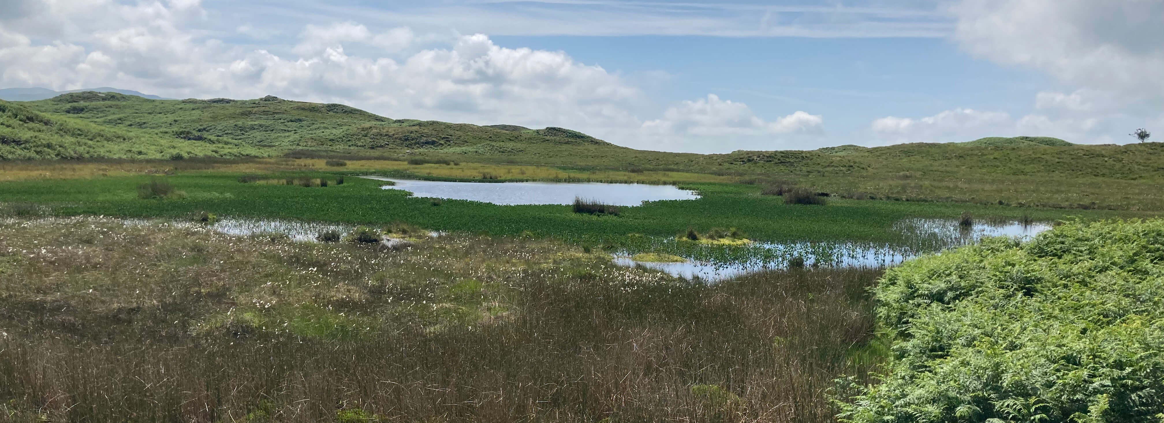
Siney Tarn
Both Blind Tarn and Siney Tarn lie within an undulating, but fairly flat, area of
boggy upland moor, with no significantly higher hills nearby. It may be upland
but it is at a height of only 225 metres so the Tarns are hardly on or by a “mountain”
as required by my dictionary. Both tarns are shallow, I assume. It is hard to see
how they could have acquired any great depth, lying in depressions on this moor.
In contrast, mountain-side tarns often have considerable depth, where glaciers have
gouged out basins.
Neither Blind Tarn nor Siney Tarn has significant inlets or
outlets: they just lie there, rising and falling a little with the rain. Typical
mountain tarns have outlets where the water leaves at the lowest point of the rim,
although there are exceptions, for example, another Blind Tarn, below Brown Pike.
The waters of this Blind Tarn and Siney Tarn are, I am sure (we didn’t go near enough to see),
of a much darker shade of peaty brown than that of Blea Tarn.
If we are tempted to deny that Blind Tarn and Siney Tarn are really tarns then
what do we call them? They are hardly Lakes or Waters. And not deep
enough to be Pools. Ponds maybe.
Perhaps they must be Tarns after all.
Despite the unexciting terrain, it is a quiet, pleasant oasis up here. We
walked past (what’s left of) Siney Tarn, enjoying the damsel flies and the
swallows (I think they were) dipping for a sip from the tarn. We walked just far
enough to have a view into the secretive valley of Miterdale, with its long green
slopes up to Whin Rigg and Illgill Head, at the top of the Wasdale Screes. We could
see only one building in the valley, marked on the map as an Outdoor Pursuit Centre.
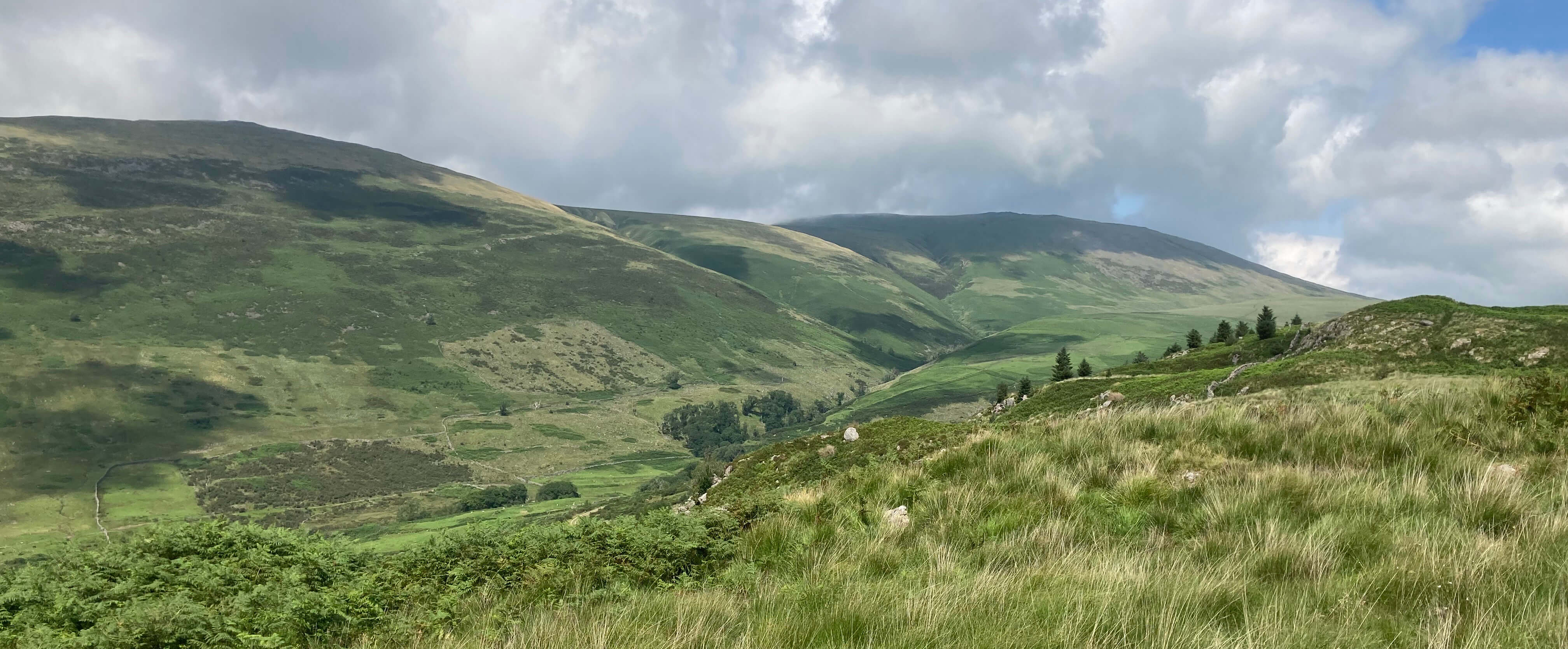
Upper Miterdale
We tarned back to pass Blea Tarn again. And then took our zigzag path down, from
where we could see that the weather had taken a tarn for the better, with all of
Eskdale basking in sunshine and the top of Scafell visible again. After this futile
attempt to pin down the nature of tarns, I fear that I will be tossing and tarning
in bed tonight.
Back at Blea Tarn

Eskdale from the path down (the conical hill is Harter Fell)
Date: July 10th 2025
Start: NY174007, Dalegarth station (Map: OL6)
Route: SW – Beckfoot – NW – Blea Tarn – W, E, NW – view
into Miterdale – SE – Blea Tarn, Beckfoot – NE – Dalegarth
Distance: 4 miles; Ascent: 180 metres
Home
Preamble
Index
Areas
Dales
Hills
Lakes
Places
Reserves
Rivers
Structures
Villages
References
Me
© John Self, 2018-

Top photo: Rainbow over Kisdon in Swaledale;
Bottom photo: Ullswater