
Home
Preamble
Index
Areas
Dales
Hills
Lakes
Places
Reserves
Rivers
Structures
Villages
References
Me
Saunterings: Walking in North-West England
Saunterings is a set of reflections based upon walks around the counties of Cumbria, Lancashire and
North Yorkshire in North-West England
(as defined in the Preamble).
Here is a list of all Saunterings so far.
If you'd like to give a comment, correction or update (all are very welcome) or to
be notified by email when a new item is posted - please send an email to johnselfdrakkar@gmail.com.
192. Who should we Trust with our Waterways?
Recently the Canal & River Trust has been
complaining that a Ł300 million cut in its Government grant will limit its ability to
care for our waterways. This made me wonder just who is, or should be, responsible for our canals and rivers.
I set out to walk home alongside the Lancaster Canal and the River Lune to mull over
this question. Before reaching the canal I passed what I think of as one of Lancaster’s finest
buildings although it doesn’t feature in its literature. It was designed by the
local architect E.G. Paley and built in 1870 with the
original name of “the Royal Albert Asylum for idiots and imbeciles of the seven northern
counties”. In the 1960s it had over a thousand patients. It was closed as a hospital in 1996
and today it is the rather
private Jamea Al Kauthar Islamic College.
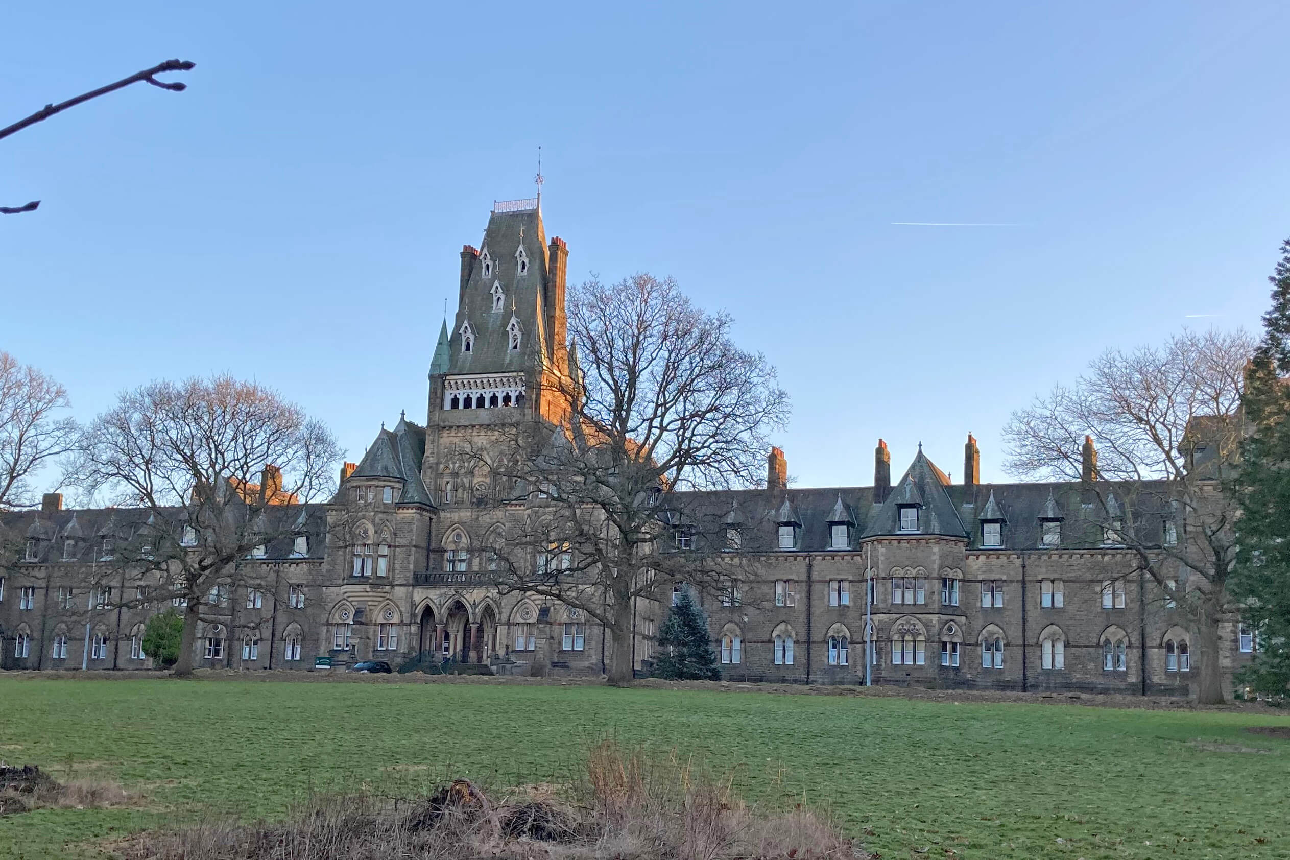
Left: Jamea Al Kauthar Islamic College; Right:
Lancaster Canal (photo taken on a different occasion).
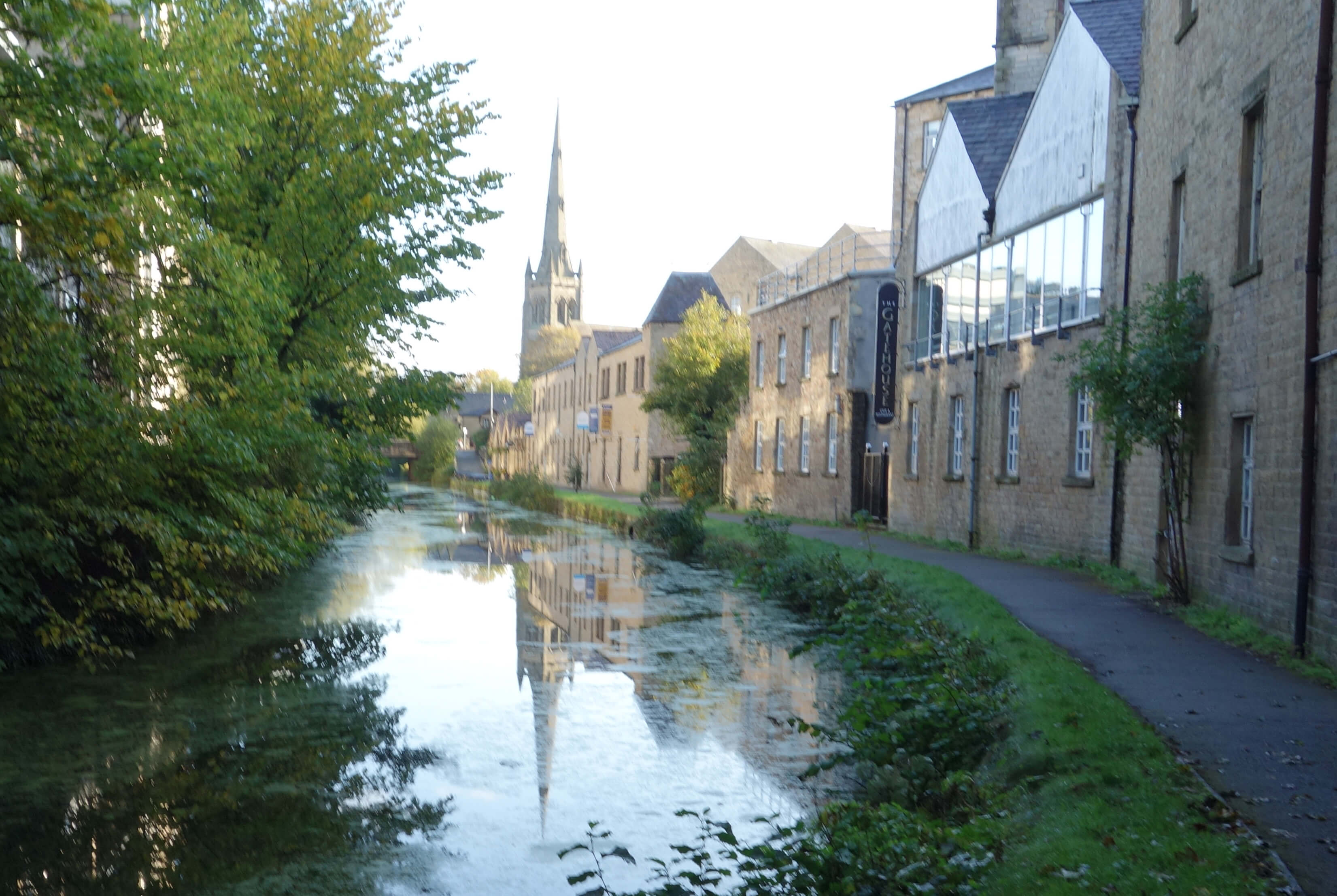
The sun had not yet risen
sufficiently to lift the gloom along the canal from the South Road bridge but I could see that
the area had been somewhat revitalised, with newish flats overlooking the canal and offices
occupying some of the old mill buildings. Despite numerous proposals over the decades, some
areas of dereliction still serve as car parks – which perhaps the City Council prefers since
they are significant sources of income that the council can control.
The canal seemed perfectly pleasant. I noticed no supermarket trolleys or the like
tipped in it. There were a few dog-walkers and joggers about but otherwise it was quiet.
I don’t know how lively the canal is in summer months but I’m sure that the canal is, or
could be, an attractive feature of the city of Lancaster.
 The Canal & River Trust seems to be mainly concerned with canals rather than rivers,
judging by its website. It says that it looks after 2,000 miles of waterways but that must be
almost all canals. Wikipedia
lists 162 canals in England, the 10 longest of which total over 1,100 miles. Lancaster Canal
is the 11th longest at 61 miles. Our rivers must be several thousands of miles more. There is
no precise definition of a river. If we include all the tributaries then determining the total
length would be like determining the length of a fractal, which is infinite. Anyway, the
Lancaster Canal is within the Trust’s remit.
The Canal & River Trust seems to be mainly concerned with canals rather than rivers,
judging by its website. It says that it looks after 2,000 miles of waterways but that must be
almost all canals. Wikipedia
lists 162 canals in England, the 10 longest of which total over 1,100 miles. Lancaster Canal
is the 11th longest at 61 miles. Our rivers must be several thousands of miles more. There is
no precise definition of a river. If we include all the tributaries then determining the total
length would be like determining the length of a fractal, which is infinite. Anyway, the
Lancaster Canal is within the Trust’s remit.
The Canal & River Trust says that
what it considers to be a cut of Ł300m is a reduction "in real terms of more than 40%".
Yes, the previous grant was for Ł750m, so a cut of Ł300m does look like a 40% cut.
However, that grant was for 15 years (so, Ł50m a year).
The proposed new grant of Ł400m is for a 10-year period, starting 2027 (so, Ł40m a year).
Has inflation been high enough to turn that 20% cut into 40%?
The Canal & River Trust was established by the Government as a charity in 2012, to
replace the old British Waterways. How many charities are there that have been set up with a
Ł750m Government grant? The charity is clearly not independent of Government – although
the latter wishes it to become so. The Government says that the Ł10m a year decrease is not a
cut, because it was always understood, at least by them, that the Ł750m was an initialisation
grant. The Trust was expected to increase its income from other sources. I can't imagine
what other sources there are that will contribute millions of pounds a year for such a cause.
It is possible to become a 'friend' of (essentially, to give a donation to) the Canal
& River Trust but not, I think, a member with voting rights, as you can
for, say, the National Trust.
I am always interested in the governance of charities that plead poverty and seek support from
the public for their worthy objectives. The Canal & River Trust has an 11-person Executive
Team and an up-to-50-(currently 34)-person Council. I didn’t recognise the name of any of
them (I thought there might be a renowned environmentalist amongst them). Who appoints the
Executive Team? And if it's the Board of Trustees (another 11 names), who
appoints them? I am sure
that the Government oversees the use of its (or our) Ł750m, plus soon Ł400m,
with its customary diligence.
The Trust has both investments and reserve funds of about Ł1 billion. The salary of
the Chief Executive was Ł224,503 in 2022/2023. Our canals – valued havens of peace and corridors
for wildlife – must be more valued than I thought.
I walked on to the Lune Aqueduct, with a biting wind blowing down-river. I noticed
that the aqueduct has acquired a red plaque from the
Transport Trust, another of our
estimable Trusts, for being “the largest all-masonry aqueduct in Britain”. This aqueduct has
had two major repairs in the last decade, both paid for by the Canal & River Trust, I assume.
I dropped down to the path along the old railway line, beside the River Lune.
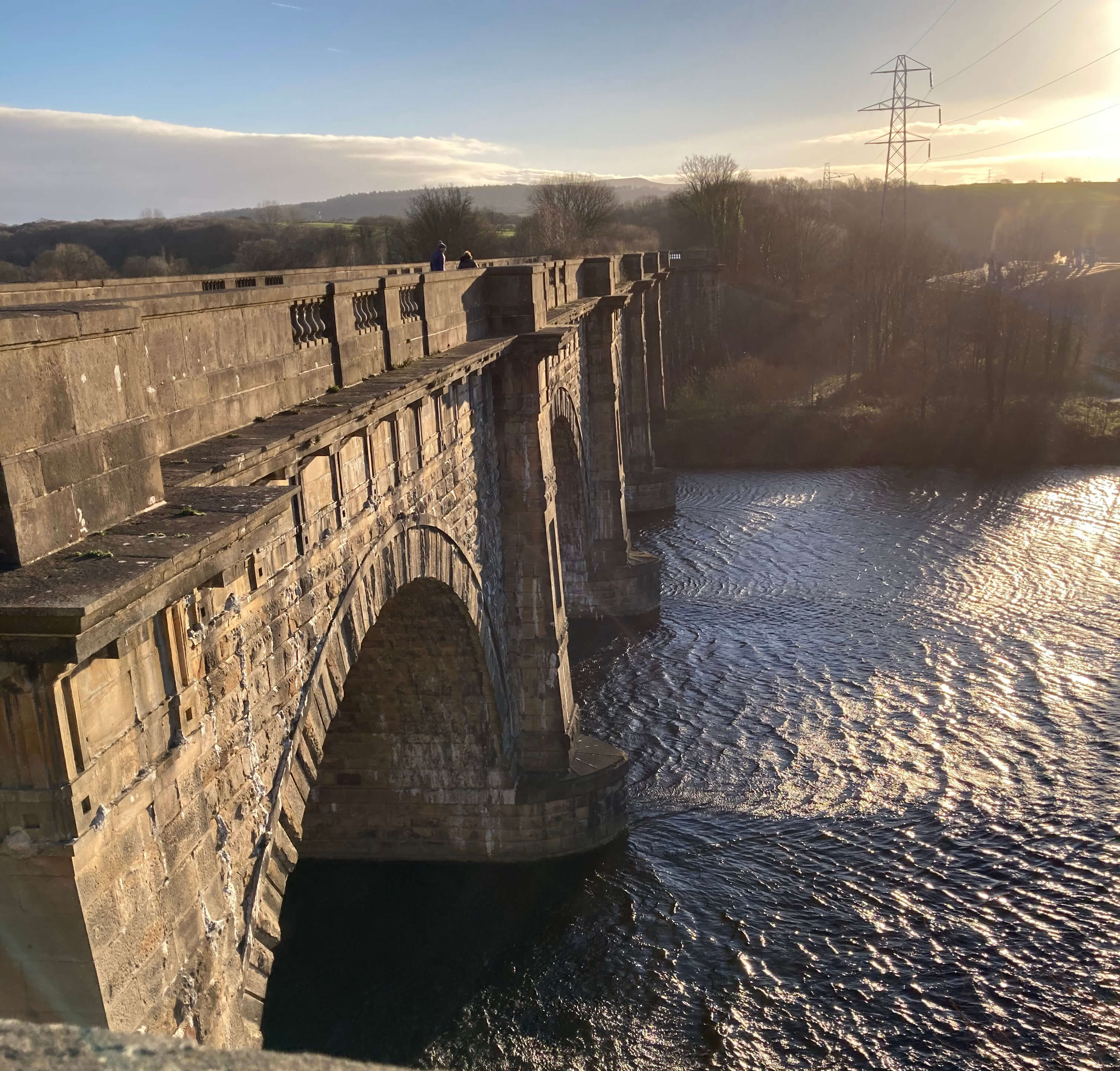
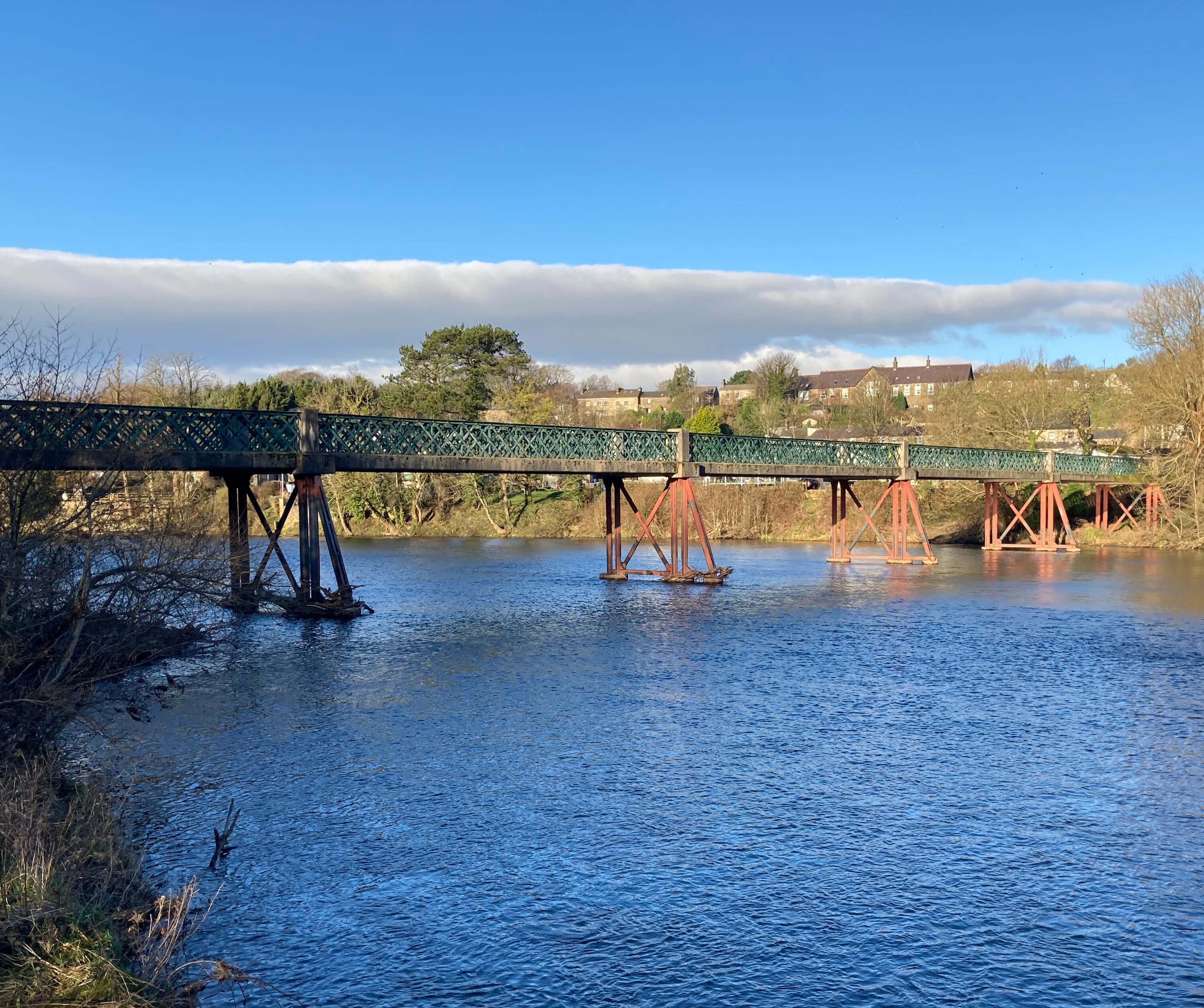
Left: Lune Aqueduct; Right:
Halton Bridge at Denny Beck.
 We know who is responsible for the Lune – the Environment Agency. We always see some
representative of the EA in TV reports of flooded or polluted rivers. The EA is
described as an “executive non-departmental public body, sponsored by the Department
for Environment, Food and Rural Affairs”. It is therefore effectively under the
control of the Secretary of State for Environment, Food and Rural Affairs. The present
Government has had five such ministers in four years: can you name the present one,
after the latest cabinet reshuffle? Since a shuffle is to produce randomness, perhaps
it doesn’t matter who it is, as all cabinet members are assumed equally knowledgeable about everything.
We know who is responsible for the Lune – the Environment Agency. We always see some
representative of the EA in TV reports of flooded or polluted rivers. The EA is
described as an “executive non-departmental public body, sponsored by the Department
for Environment, Food and Rural Affairs”. It is therefore effectively under the
control of the Secretary of State for Environment, Food and Rural Affairs. The present
Government has had five such ministers in four years: can you name the present one,
after the latest cabinet reshuffle? Since a shuffle is to produce randomness, perhaps
it doesn’t matter who it is, as all cabinet members are assumed equally knowledgeable about everything.
The EA's budget has, of course, been greatly reduced since 2010. I say "of course" but there
is no of course about it. It seems 'of course' because almost everything has been reduced since 2010.
It was a Government choice to decrease funding of the EA's protection services from the equivalent
of Ł213m (taking inflation into account) in 2010 to Ł94m in 2021.
The EA’s oversight of our rivers is not as straightforward as it may seem.
When we needed work done on our beck-bank we knew that, as riparian owners, permission
is needed for any work in or beside a watercourse. But permission from whom? We
assumed the EA but their brief ends, it seems, with the major rivers. Little tributaries
like ours are the responsibility of the County Council. How the EA can ensure the
well-being of the rivers while ignoring their tributaries I don’t know. (This was a
few years ago: perhaps the arrangements have changed?) The County Council seemed
more concerned about the built environment than the natural one – reasonably enough,
as they wouldn’t want work to, say, cause flooding that damaged bridges or roads.
Of course, it is impossible to manage our rivers (including the tributaries) as enclosed
entities. The health of a river is determined mainly by what enters it, such as various
chemicals from farms and sewage from water utilities.
 I walked on into the wind, with my head achingly cold. I paused at the
Denny Beck Bridge and noticed the platform provided for disabled anglers, installed by
the Lune Rivers Trust. How do the Rivers Trusts fit into all this? There are
60 Rivers Trusts under the umbrella of
The Rivers Trust, each concerned with one or
more rivers. The Rivers Trusts are charities, relying on volunteers with usually a
few paid executives. They do not receive direct Government grants – but they are not
really independent of Government because most of their income comes from projects paid
for, and usually initiated by, Government agencies such as the EA. The Government
presumably feels that it is better to stay at arm’s length and leave those with local
knowledge to carry out the work.
I walked on into the wind, with my head achingly cold. I paused at the
Denny Beck Bridge and noticed the platform provided for disabled anglers, installed by
the Lune Rivers Trust. How do the Rivers Trusts fit into all this? There are
60 Rivers Trusts under the umbrella of
The Rivers Trust, each concerned with one or
more rivers. The Rivers Trusts are charities, relying on volunteers with usually a
few paid executives. They do not receive direct Government grants – but they are not
really independent of Government because most of their income comes from projects paid
for, and usually initiated by, Government agencies such as the EA. The Government
presumably feels that it is better to stay at arm’s length and leave those with local
knowledge to carry out the work.
I paused at the Halton weir, in case I could see any salmon leaping. Perhaps
it’s too late in the season? Anyway, I saw nothing, as has been the case for a
while. Beyond the weir I left the old railway line to walk by the river, with some
trepidation, as I expected it to be very muddy. However, the cold wind had frozen the mud.
So, I continued by the riverside beyond the Crook o’Lune, which is indeed a fine walk and
one that I haven’t taken since they’ve planted many trees by the river (I wonder whose initiative that was).
Of course, we’d like healthy waterways – but is it too late? According to a Rivers
Trust
report of 2021 only
14% of England’s rivers are in good ecological health,
and every single one fails to meet chemical standards. I doubt that the rivers have
improved since 2021, with one of our afore-mentioned
Secretaries of State commenting that “reaching the gold standard for ecological status
would mean taking us back to the natural state of our rivers from the year 1840”, which
was “not practical or desirable”.
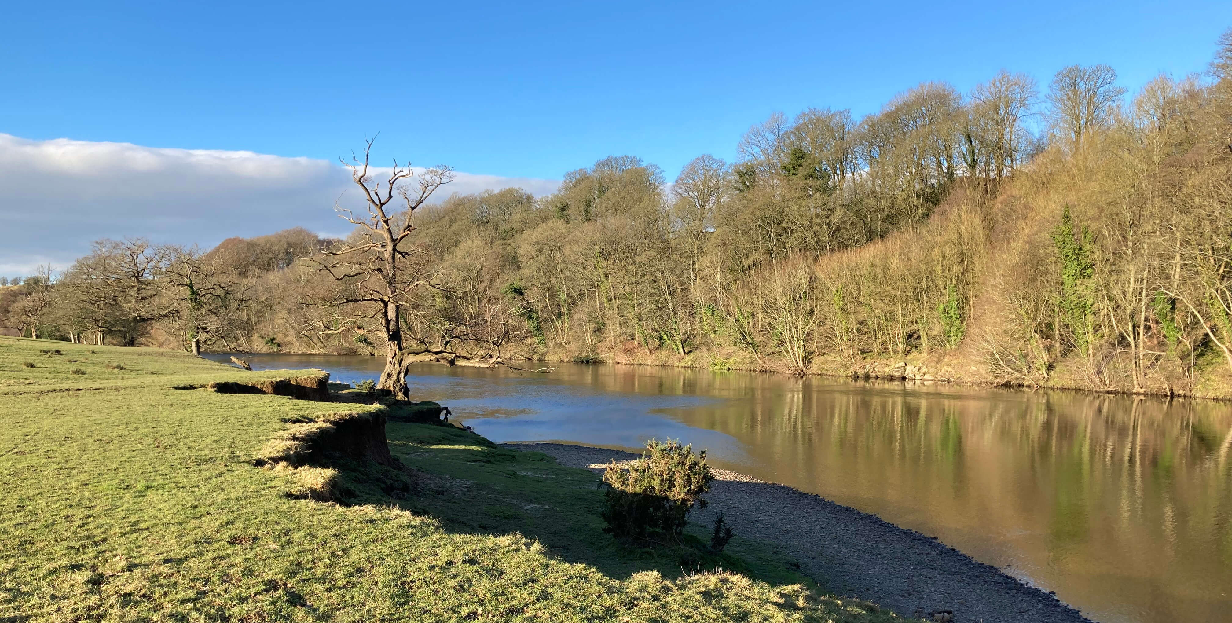
River Lune downstream from the Crook o'Lune
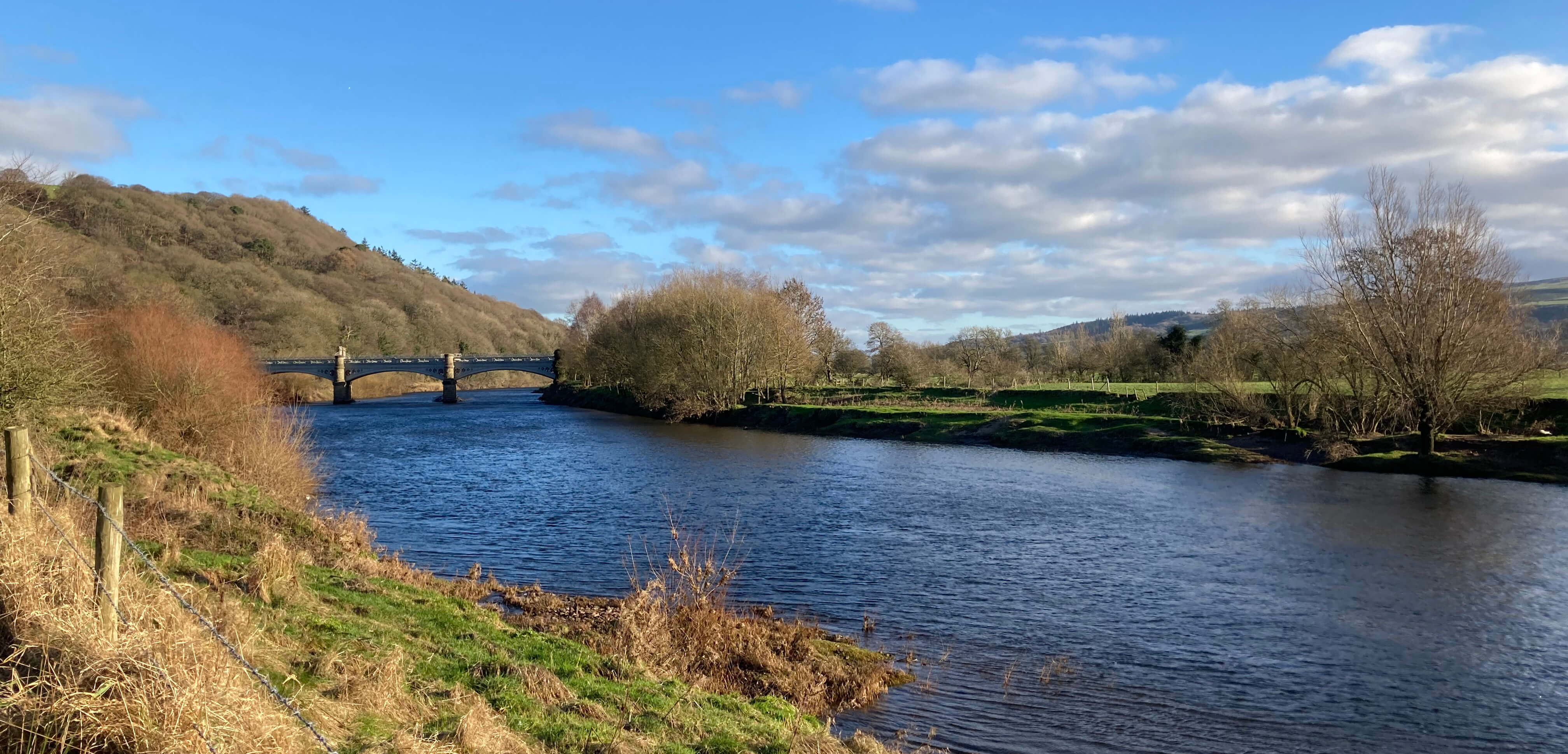
River Lune upstream from the Crook o'Lune, with Waterworks Bridge ahead
Date: January 9th 2024
Start: SD473594, Ashton Road (Map: OL41)
Route: (linear) N on Ashton Road, past hospital – canal
bridge – NE, NW – Lune Aqueduct – NE, E – Halton weir – E by Lune – Crook o’Lune – NE –
Waterworks Bridge – S – Brookhouse
Distance: 8 miles; Ascent: 20 metres
Home
Preamble
Index
Areas
Dales
Hills
Lakes
Places
Reserves
Rivers
Structures
Villages
References
Me
© John Self, 2018-

Top photo: The western Howgills from Dillicar;
Bottom photo: Blencathra from Great Mell Fell