
Home
Preamble
Index
Areas
Map
References
Me
Drakkar
Saunterings: Walking in North-West England
Saunterings is a set of reflections based upon walks around the counties of Cumbria, Lancashire and
North Yorkshire in North-West England
(as defined in the Preamble).
Here is a list of all Saunterings so far.
If you'd like to give a comment, correction or update (all are very welcome) or to
be notified by email when a new item is posted - please send an email to johnselfdrakkar@gmail.com.
75. To Ward's Stone: A Classic Walk?
 A book of æClassic WalksÆ (Wilson and Gilbert, 1982) describes 32 walks in England, including 10 in North-West England. They are:
ò Buckden to Conistone via Buckden Pike and Great Whernside (15 miles (linear); 6-7 hours)
ò The Buttermere circuit, including Red Pike, Grey Knotts and Robinson (13 miles; 7 hours)
ò The Coniston Fells, including the Old Man, Swirl How and Wetherlam (14 miles; 7 hours)
ò Great Gable from Seathwaite (6 miles; 4-5 hours)
ò Helvellyn by Striding Edge and Swirral Edge (8 miles; 5-6 hours)
ò High Street from Patterdale to Troutbeck (12 miles (linear); 6 hours)
ò Malham Cove, Malham Tarn and Gordale Scar (7 miles; 5 hours)
ò Saddleback (or Blencathra) from Mungrisdale by Sharp Edge (8 miles; 6 hours)
ò WardÆs Stone, from Tarnbrook via Jubilee Tower (10 miles; 4 hours)
ò Wharfedale from Ilkley to Kettlewell (24 miles (linear); 8-9 hours)
Nobody would quibble much about any of those being in the top ten classic walks of North-West England û with one possible
exception, that exception happening to be the only one of the ten that I can reach by walking from home. I thought that I should walk to WardÆs Stone again (but from home for the first time) to see if my familiarity with it has lessened my appreciation of its classicality.
The book describes a walk from the south side of WardÆs Stone, from Tarnbrook and via
Jubilee Tower. The authors had little choice in the matter because in 1982 access to WardÆs Stone was very much restricted, with only a narrow access strip along the watershed ridge. Today, now that most of Bowland is open access land, WardÆs Stone may be reached from many directions. An approach from the north (such as from my home) is perhaps to be preferred because then the vista across to the Dales and the Lakes is in view all the way up.
Once I had reached the access area south of Skelbow Barn I swung south-east to pick up an old path, not much used, I think, nowadays, that climbs south beside dilapidated grouse butts that are definitely not much used nowadays. I reached fresh snow and very helpful it was. It had settled more upon the path than it had upon surrounding heather and rock and therefore provided me with a white line to follow. New snow shone on the distant Lakes and Dales tops: a marvellous, sweeping, 180-degree prospect.
I eventually reached a shootersÆ track. These tracks, much as I'd prefer them not to be scarring the landscape,
do at least enable walkers to stride out much more easily than would otherwise be the case.
A carpet of virgin snow sparkled on the track. It was almost a shame to walk upon it. Only the occasional
grouse, rabbit or hare had disturbed it.
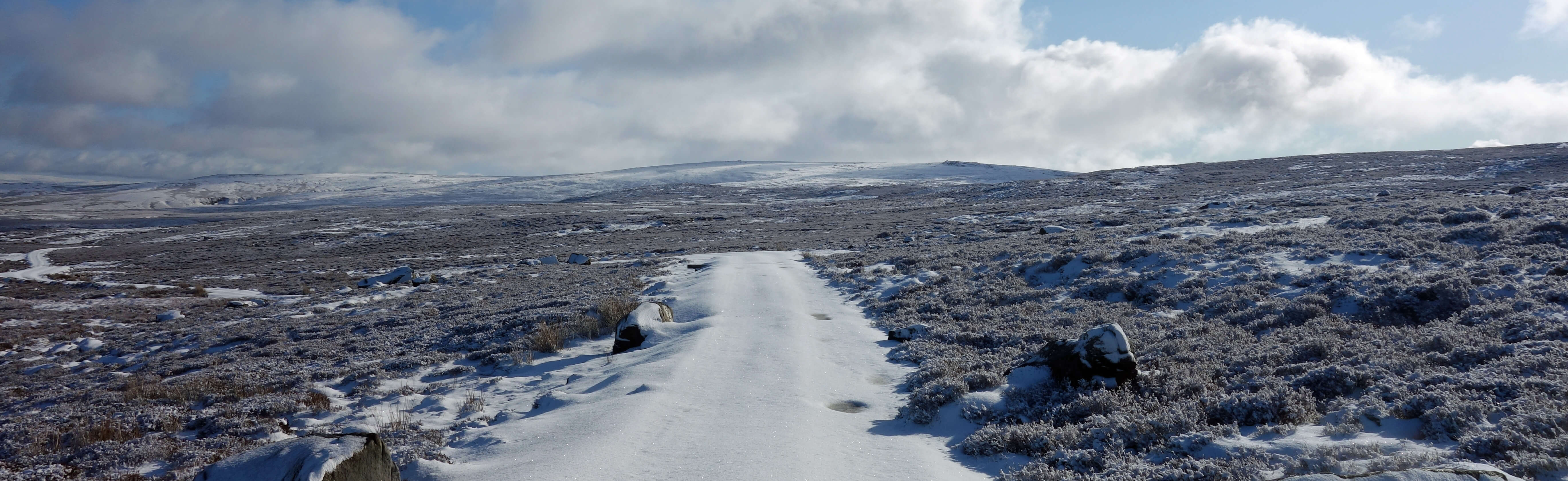
The shooters' track, with Ward's Stone on the horizon
The track headed east and then climbed south and just as I was beginning to think that I might be unable, in the snow, to
locate the path east to WardÆs Stone I noticed a single set of footprints crossing my path, obviously of a walker striding
purposefully from Grit Fell to WardÆs Stone. I followed the footprints. This is a difficult path at the best of times, through heather and around boggy pools, especially after wet weather, as weÆve had. Locating the pools, presumably frozen, under snow would not be easy but by following the footprints I could at least see where he or she had fallen in.
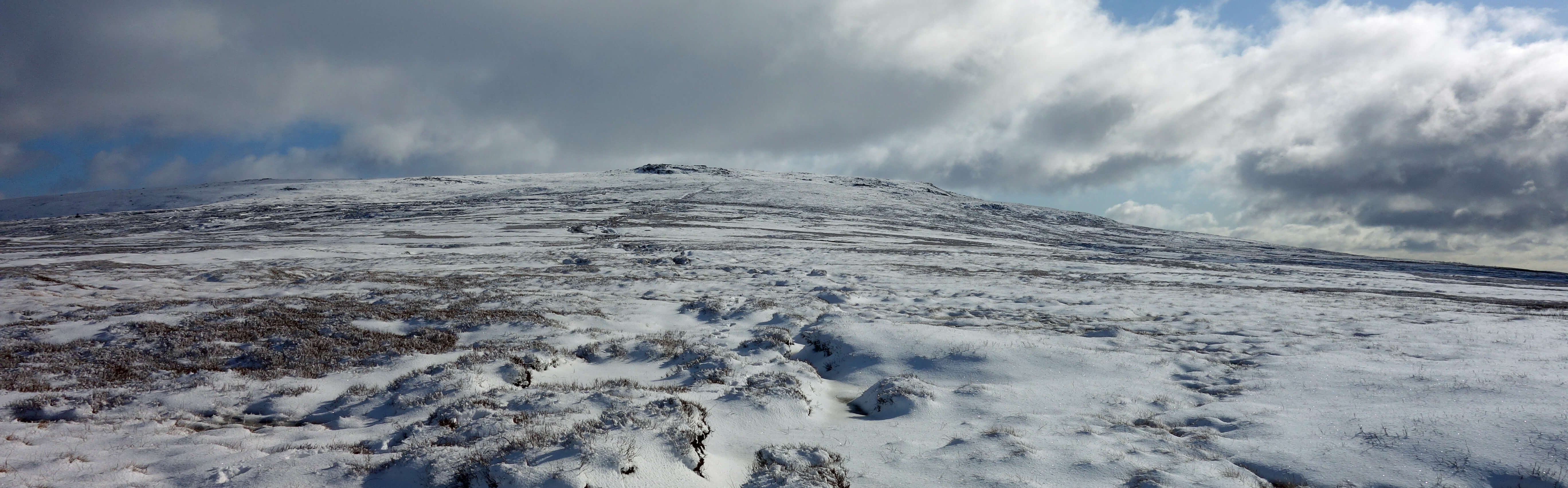
Following footprints to Ward's Stone
I was led unerringly to the trig point ahead. I never saw the owner of the footprints to thank him
or her û or anyone else. This trig point (560 metres) is, in fact, not quite the top,
and neither is a second trig point (561 metres) half-a-mile further on.
The highest point (563 metres) of Ward's Stone (and the highest point in the Forest of Bowland)
is at a peat hag about midway between the two.
I wasnÆt fussed about getting to the exact top.
Walking in uneven snow is exhausting and with a cold wind and dark clouds gathering over
Morecambe Bay (although it was still sunny on the hills of the Dales and Lakes) I decided to
drop down north over rough moorland, heading for Deep Clough, which I could see as a
tiny farm two or more miles away, where there is a permissive path allowing entry to or exit from the access area.
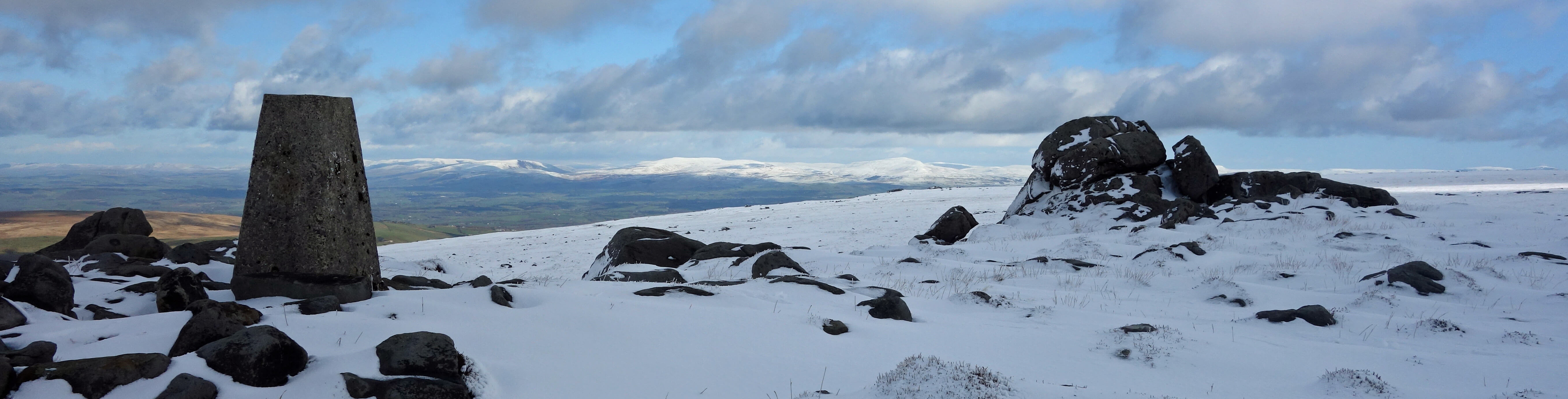
Ward's Stone and trig point
It was an enjoyable yomp across a snowy wilderness but perhaps a little reckless. The snow made it impossible to know how far
my foot would sink before reaching rock, heather or bog. I knew that there was nobody within a mile of me and if I were to
slip on a rock and break a leg then there would be nobody within a mile of me for some time. So, I took every single step carefully, pausing every so often to absorb my surroundings. Grouse flew up, telling me to go-back, go-back, but I ignored their advice. Eventually, after slow, steady walking I escaped the snow, crossed Foxdale Beck within the hidden valley of, I suppose, Foxdale, reached the permissive path and then followed the footpath through Littledale.
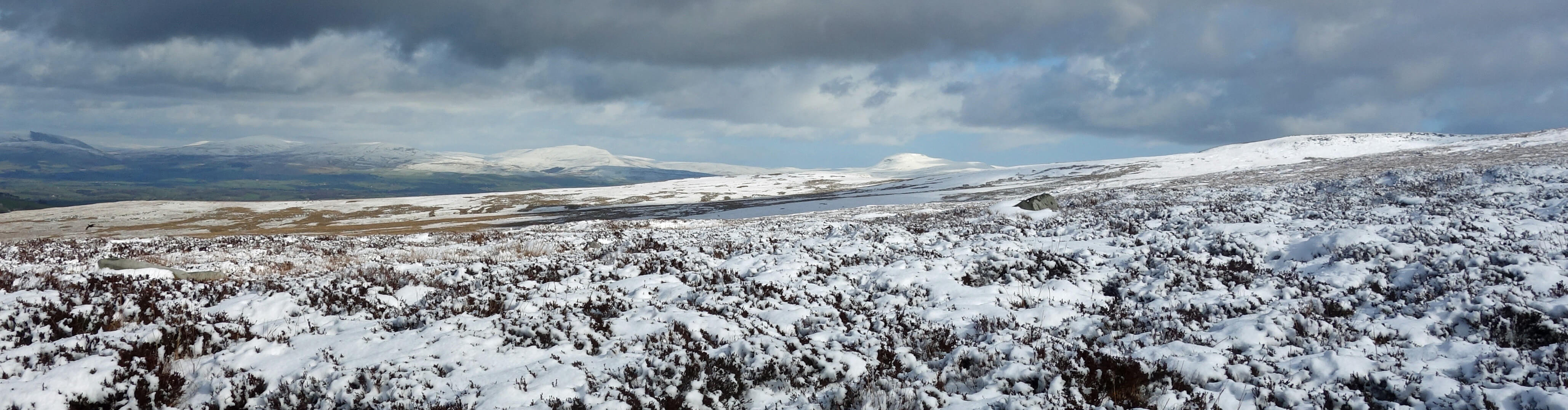
A distant view of Whernside (17 miles away) and Ingleborough (14 miles away) from the
moor below Ward's Stone
So, is it a classic walk? Well, IÆd say that while all walkers will enjoy the other nine on the list, there will be some who find WardÆs Stone not to their taste. It is rough walking, through gaunt, rugged terrain, with not much variety and few noteworthy features. The distant views are, of course, tremendous but close by it is all heather and millstone grit, dull brown and grey everywhere, except when it is under snow, of course.
Wilson and Gilbert (1982) says that ôfor a walk to be classic it must be not only of excellent quality, but it must have withstood the test of timeö. On that basis, the WardÆs Stone walk should have been disqualified but perhaps it was included precisely to celebrate the fact that such a walk had only recently become possible. In the 1960s the Forest of Bowland was the largest area of moorland in England where walking was forbidden. Despite decades of campaigning, with well-attended rallies and with confrontations between rambling clubs and gamekeepers, landowners were adamant that their land was private, reserved for grouse and grouse-shooters. However, in 1973 agreement was reached that the public would be allowed on three small areas, around Clougha, around Fair Snape Fell, and along the narrow access strip over WardÆs Stone. So, the WardÆs Stone walk had hardly æwithstood the test of timeÆ by 1982.
According to Hill (1980), the 1973 agreement was only possible after landowners had been assured that they would receive an annual compensation. Bowland landowners received ú2.94 per acre (I picture billionaire landowners haggling over the pence). Are we still paying landowners to be
able to walk on these moors?
Date: February 27th 2020
Start: SD543644, Brookhouse (Map: OL41)
Route: SE on Littledale Road, track û Udale Bridge û S û Belhill Farm û S, W, SW
û access area û S, SE, S û
shootersÆ track û E, SE, E û WardÆs Stone û N, NE (permissive path by Ragill Beck), W û Crossgill û NW û
Brookhouse
Distance: 11 miles; Ascent: 500 metres
Home
Preamble
Index
Areas
Map
References
Me
Drakkar
® John Self, Drakkar Press, 2018-

Top photo: The western Howgills from Dillicar;
Bottom photo: Blencathra from Great Mell Fell