
Home
Preamble
Index
Areas
Map
References
Me
Drakkar
Saunterings: Walking in North-West England
Saunterings is a set of reflections based upon walks around the counties of Cumbria, Lancashire and
North Yorkshire in North-West England
(as defined in the Preamble).
Here is a list of all Saunterings so far.
If you'd like to give a comment, correction or update (all are very welcome) or to
be notified by email when a new item is posted - please send an email to johnselfdrakkar@gmail.com.
70. Up the Conder
The Conder is an unassuming river, most of the time. It arises on Black Fell, below Clougha Pike, and runs
inconspicuously, never more than a few feet wide, for about eight miles through what nobody has ever called
Conderdale. This is a surprisingly broad valley, there being over two miles between Clougha Pike and the
Langthwaite hills on the opposite side. After its initial spurt off Black Fell, the Conder declines gently
towards the coast, with no waterfalls or other excitements along the way. It ends not by boldly entering
Morecambe Bay of its own accord but by sidling into the River Lune at Conder Green, just before the Lune
enters the bay.
An iffy forecast for later in the day led me to begin my walk before sunrise, setting off from Glasson marina and aiming to walk up beside the Conder to its source (and then home). The path along the old railway line to Conder Green was icy and required attention that might otherwise have been directed towards identifying the birds stirring in the dark estuary. A bright white little egret was all that I could discern. The tide was out and the Conder ran low below its muddy banks towards the Lune. As I made my way to the Glasson spur of the Lancaster Canal the sky evolved through oranges and purples. In its own good time the sun arose over the Bowland hills but, alas, within ten minutes it disappeared behind a bank of cloud, where it hid for the rest of the day û which wasnÆt what had been forecast.
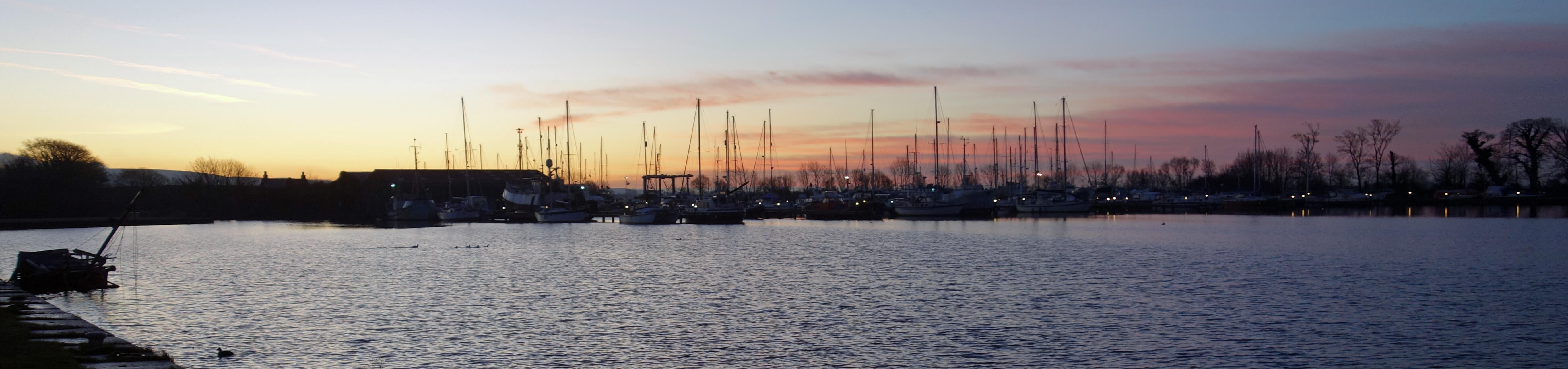
Glasson marina
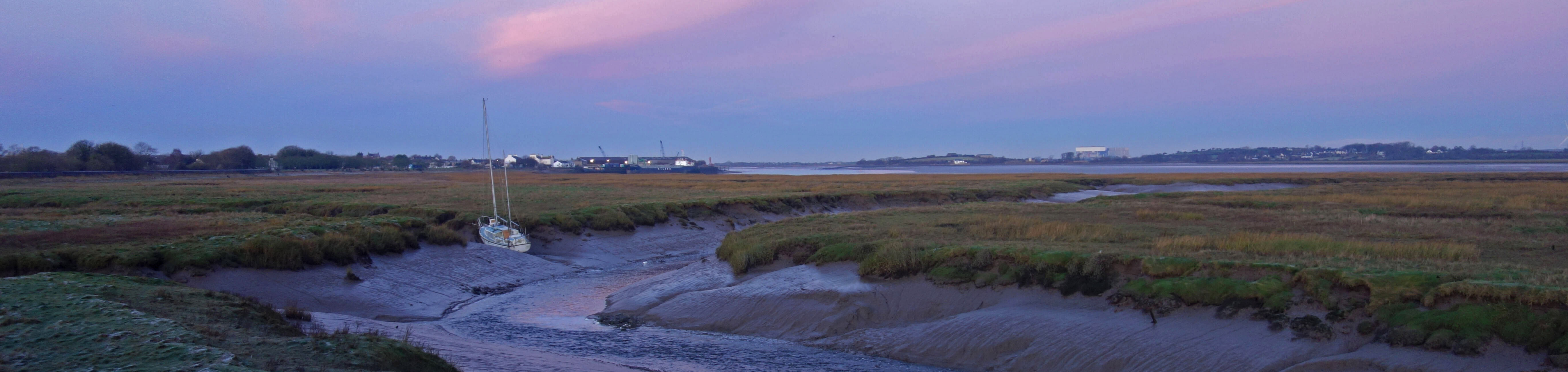
River Conder at Conder Green
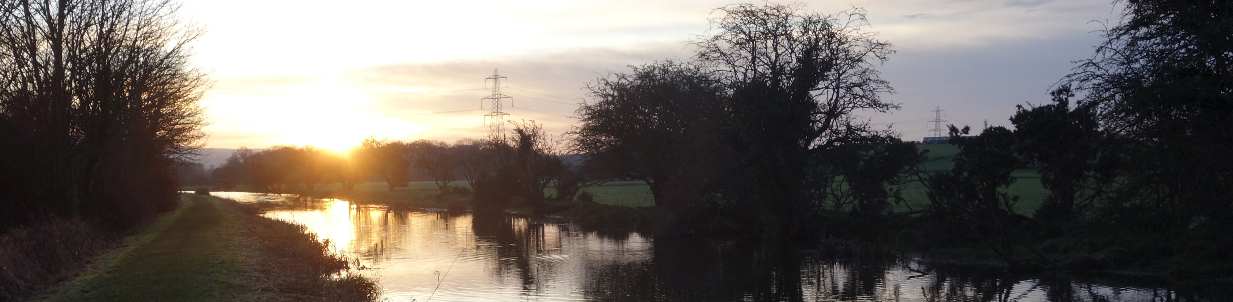
Glasson canal and sunrise
The canal here is banked up above the level of the Conder, which meanders unseen in the fields to the left. I continued north on the canal mainly to see the River Conder flowing under it. ItÆs an odd juxtaposition û a flowing river crossing a still canal. I followed the path of the Conder through the village of Galgate, for the residents of which I added that æmost of the timeÆ to my first sentence. The Conder floods the village with depressing regularity. Here the river passes through a fairly narrow channel within high walls and, of course, most of the time it flows harmlessly enough. However, the Conder has a large catchment area for such a normally docile river and if thereÆs a cloudburst on the Bowland fells then, as there is little to detain it, the water must rapidly fill this channel.
North of Galgate, at the hamlet of Ellel, I took a footpath east. The Conder protects its privacy by
having no public footpaths anywhere on its banks except here û and this short footpath passes under the M6,
so it hasnÆt much appeal to walkers. Disappointingly, the cloud was now dampening what little colour there
was on a December morning and, with the Conder inaccessible and hidden away down to the north, I settled in for
a spell of road-walking.
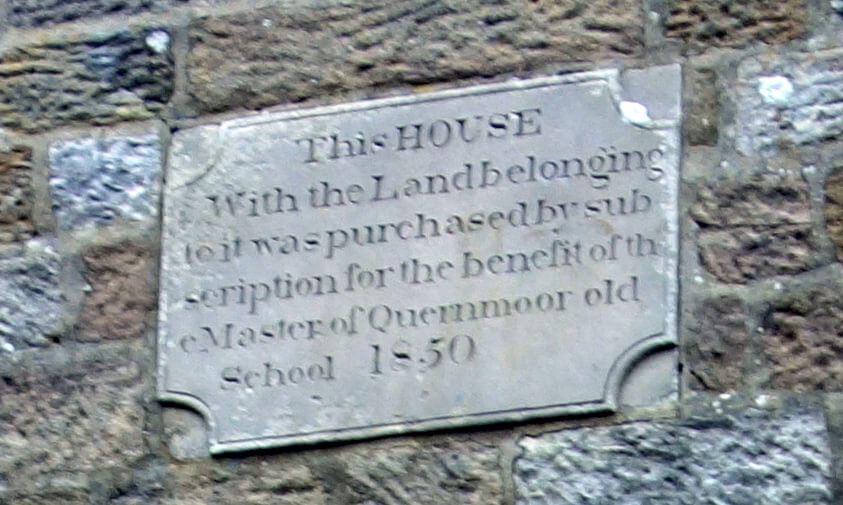 At the corner of Long Lane the OS map marks an æOld School HouseÆ but the plaque says itÆs the old
schoolmasterÆs house, which seems more plausible given its isolation. Did the schoolmaster teach
his pupils to split the word th
At the corner of Long Lane the OS map marks an æOld School HouseÆ but the plaque says itÆs the old
schoolmasterÆs house, which seems more plausible given its isolation. Did the schoolmaster teach
his pupils to split the word th
e over two lines, as on the
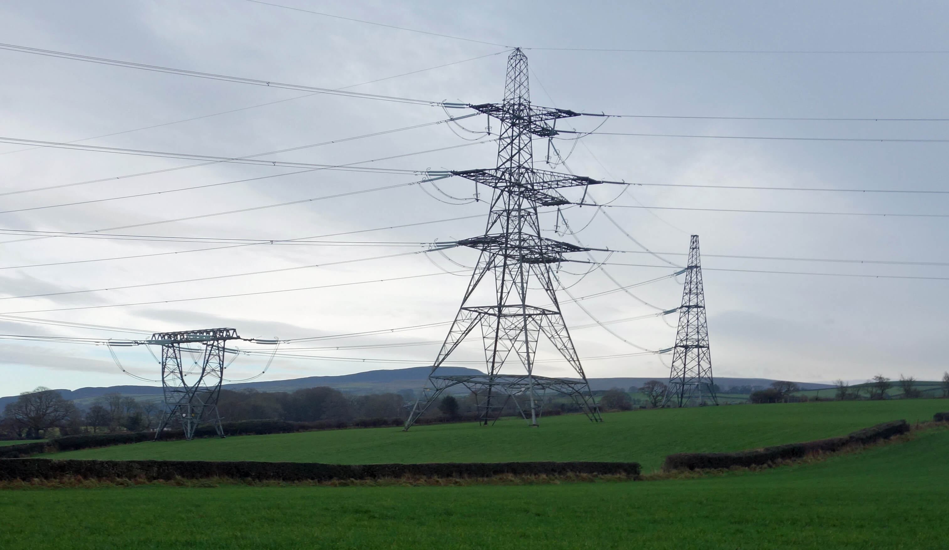
plaque? Long Lane was not as quiet as might be expected, with various workmen wandering about. Our utility services think that this valley deserves to be cluttered with enormous pylons, large reservoirs (on the Langthwaite hills) and fenced-off constructions. A view of Clougha Pike was somewhat obscured, as the photo shows.
Halfway along Long Lane I cut down to Conder Side Farm. I felt a duty to see anything that had æConderÆ in its name. Sure enough, the farm was beside the Conder, which I crossed by a nondescript bridge. I continued east and then dropped down from the other side to Conder Mill, which with a mill pond and a scheduled bridge is a pretty setting (when in sunshine). Just above Conder Mill the Conder is joined by its largest (but still not large) tributary, Rowton Brook.
After walking through the village of Quernmore and past the isolated St PeterÆs church I crossed
the Conder again, now quite diminutive, by a bridge that nobody passing on the road would notice as a
bridge. Here I needed to swing east because the Conder flows from what looks like a side valley, with the
main valley north having no significant watercourse. An explanation for the width
of the valley, and the fact that the Conder seems much too small for it, may now be appreciated û the River Lune once flowed through here before it was diverted towards Lancaster by glacial deposits.
Passing the peacocks at Cragg Cottage and crossing the Conder again, I entered the Bowland Access Area
near Cragg Wood. This wood, known in particular for its old sessile oaks, is one of only four Special Areas
of Conservation (SACs) in Lancashire. It is, however, private land. After too much road-walking my boots
welcomed the rather rocky and muddy track through heather above the Conder and also enjoyed their first
walk of the winter in snow, albeit only the soggy remnants of the snowfall of a few days ago.
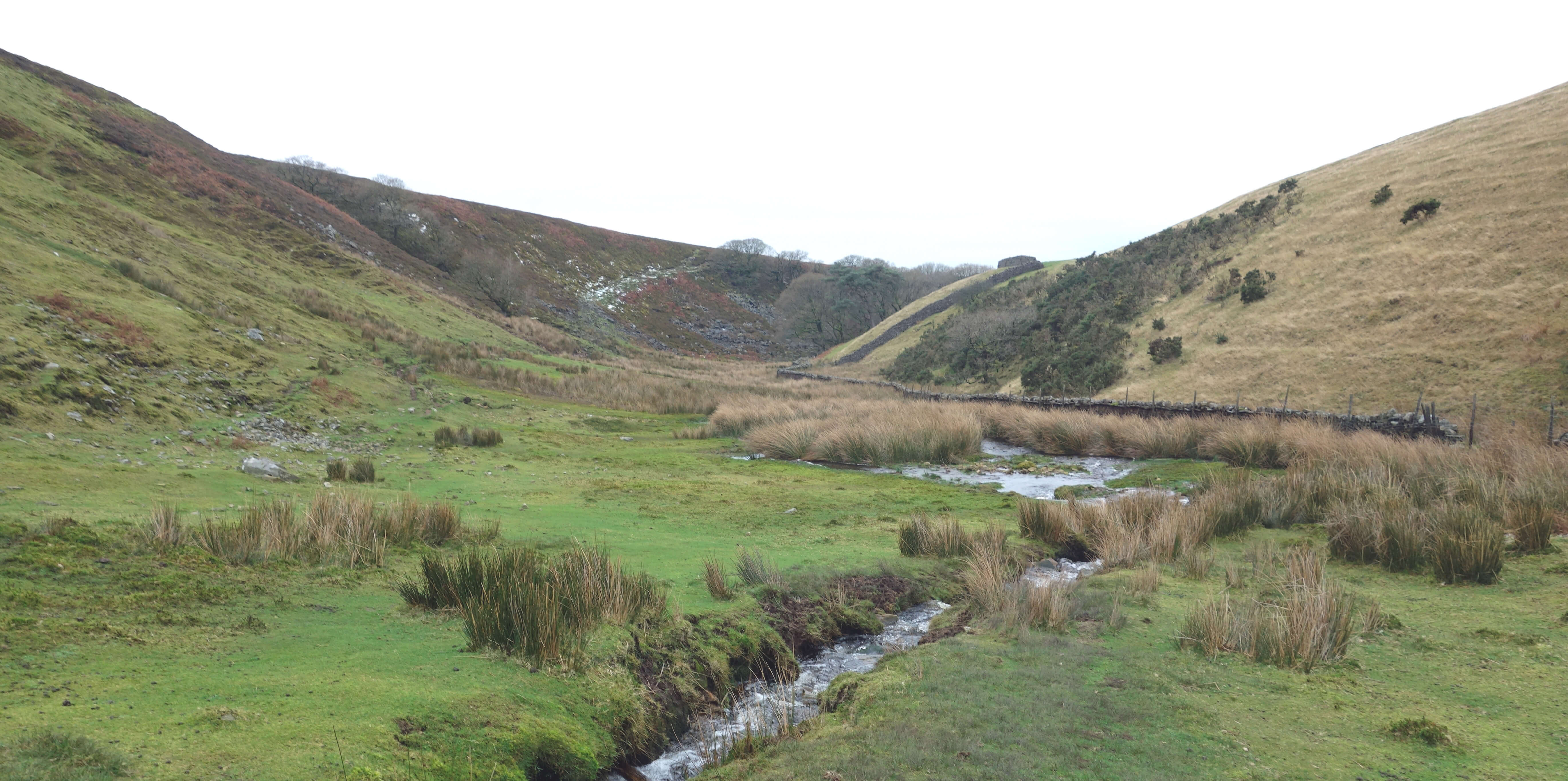
Now, at last, I reached the source of the Conder û or as close to it as you can reasonably
expect after the long trek from Glasson. The true source, of course, lies higher up the slopes of
Clougha but I was content to see it gushing down through a small ravine and then swerving off west whence I had come. I crossed it for the ninth and last time, taking only a single step to do so. A few yards further on I walked by Sweet Beck, which flows north to join the Lune. It is strange to think that apart from those few yards the land between the Conder and the Lune is entirely surrounded by water û it is almost a sort of island. But something similar can be said about any watershed.
Unfortunately for my legs I still had a couple of miles to go to get home but as far as the River Conder was concerned, that was it. I said at the beginning that it is an unassuming river and I am tempted to add, paraphrasing Churchill, that it has much to be unassuming about û but that would be unfair. The river and the valley are not at their best on a cold, grey day. Me neither.
Date: December 18th 2019
Start: SD445561, Glasson (Maps: 296, OL41)
Route: (linear) E on old railway line, road û Conder Green û S, SE û hotel, canal û
SE, E, N on towpath û Ellel Hall Bridge û E û Galgate û N û Ellel û E on path under M6 û Lower Kit Brow û
NE on Kit Brow Lane, Long Lane, W û Conder
Side Farm, road û NE, SE û Conder Mill û E û Quernmore crossroads û N on Rigg Lane, NW past church,
E on Littledale Road û near Bark Barn û S (past peacocks),
SE, E û Sweet Beck û NE û Belhill Farm û N, NW - Brookhouse
Distance: 14 miles; Ascent: 200 metres
Home
Preamble
Index
Areas
Map
References
Me
Drakkar
® John Self, Drakkar Press, 2018-

Top photo: The western Howgills from Dillicar;
Bottom photo: Blencathra from Great Mell Fell