
Home
Preamble
Index
Areas
Map
References
Me
Drakkar
Saunterings: Walking in North-West England
Saunterings is a set of reflections based upon walks around the counties of Cumbria, Lancashire and
North Yorkshire in North-West England
(as defined in the Preamble).
Here is a list of all Saunterings so far.
If you'd like to give a comment, correction or update (all are very welcome) or to
be notified by email when a new item is posted - please send an email to johnselfdrakkar@gmail.com.
63. These Are a Few of My Favourite 'Superficial Things': in Crummackdale
I am still perplexed by the proposition that arose in the previous Sauntering
(62), namely, that nature-lovers absorb and are attuned to the moods
and spirit of a place rather than observe æsuperficial thingsÆ. It would seem to follow that
it is better not to know anything about those superficial things so that you are less likely
to be distracted by them. If you know too many trees then
you canÆt see the wood, perhaps. However, I fear that I have been led astray by my scientific training.
I canÆt help wanting to observe things and to know more about them.
Austwick and Robin Proctor's Scar
 I again took the bus to the Yorkshire Dales to walk around the Craven Faults and to mull over this
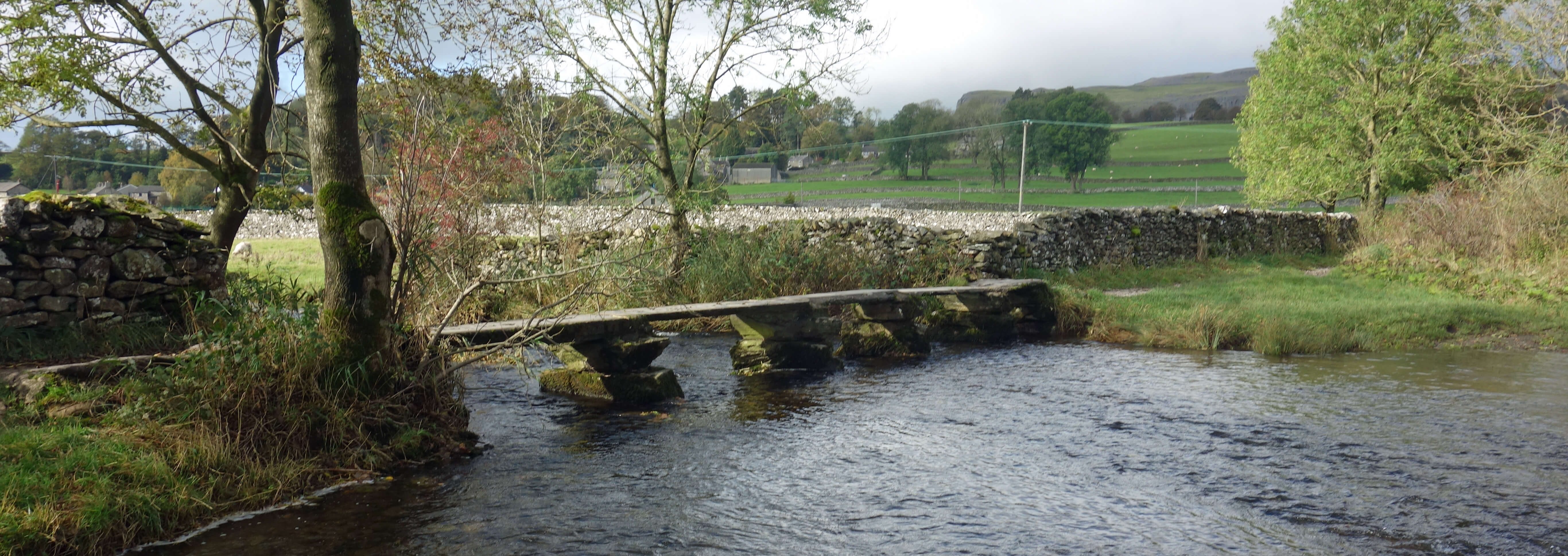
absorb-observe conundrum. I set off from Austwick, over Flascoe Bridge, one of the finest
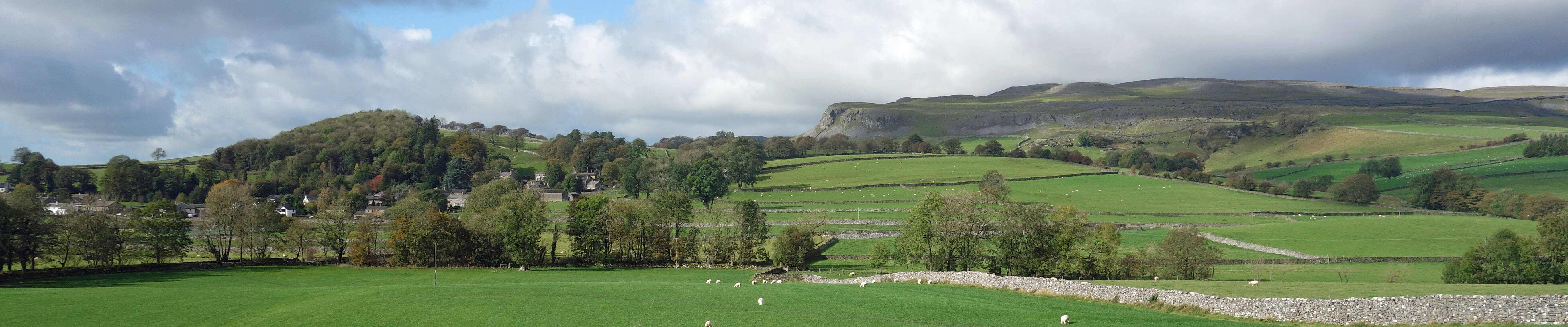
clapper bridges in the Dales (shown right), and on to the hamlet of Wharfe. I left the enclosed track to walk across the fields below Studrigg Scar. Views of the green valley of Crummackdale opened out, enclosed within a spectacular rim of limestone scars, with the heights of Ingleborough and Simon Fell beyond. The last time we were in Crummackdale, some ten years ago, two merlins argued noisily whilst nesting on the scar. This time there were again two noisy, but less argumentative, birds, which I couldnÆt see.
Could they be the same merlins? Or their descendants?
I again took the bus to the Yorkshire Dales to walk around the Craven Faults and to mull over this
absorb-observe conundrum. I set off from Austwick, over Flascoe Bridge, one of the finest
clapper bridges in the Dales (shown right), and on to the hamlet of Wharfe. I left the enclosed track to walk across the fields below Studrigg Scar. Views of the green valley of Crummackdale opened out, enclosed within a spectacular rim of limestone scars, with the heights of Ingleborough and Simon Fell beyond. The last time we were in Crummackdale, some ten years ago, two merlins argued noisily whilst nesting on the scar. This time there were again two noisy, but less argumentative, birds, which I couldnÆt see.
Could they be the same merlins? Or their descendants?
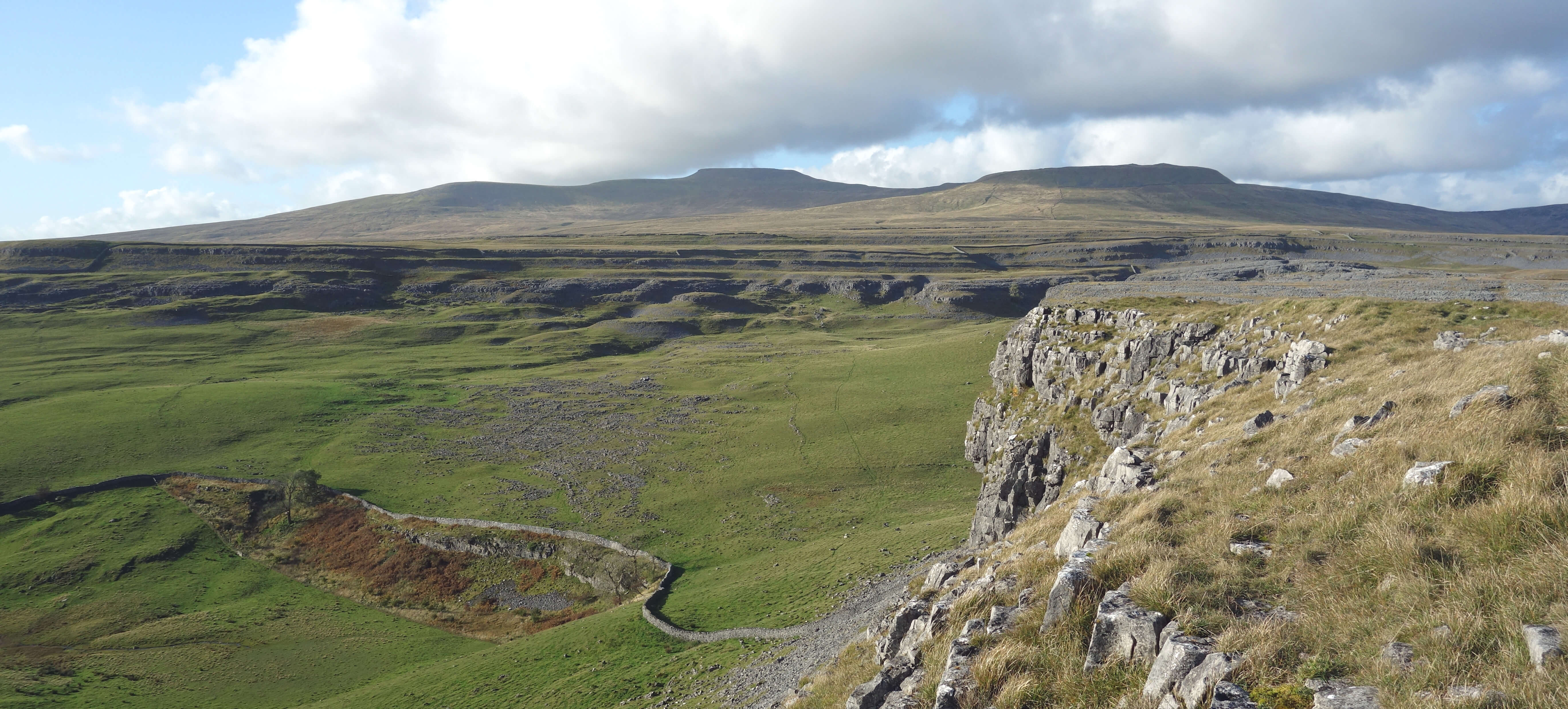
The first few times that I visited Crummackdale I did not notice a particular feature of Studrigg Scar. This omission did not, I feel, lessen my appreciation of Crummackdale at the time. By the way, there is a difference between appreciating and loving nature. I appreciate the friendliness of my postman but I donÆt love him. We tend to appreciate specific features and to love the whole. In fact, we may love despite specific features! Anyway, my point is that although I missed the Studrigg Scar feature there were plenty of other Crummackdale features for me to appreciate and, if you pushed me to be emotional about it, to cause me to love the whole.
The feature that I missed can be seen by looking to the right from the footpath.
The cliff is in two parts. The top part has roughly horizontal layers. The bottom part has layers tilted to about 60 degrees. You donÆt need to be a geologist to be intrigued by this. Most of us would say that we donÆt know anything about rocks, but of course we do. We know that rocks arenÆt all the same. We can name a few (granite, limestone, millstone grit, quartz, say) and have a stab at identifying them. We know that rocks are heavy, and that they are old. We know therefore that the rocks of Studrigg Scar didnÆt just get blown into their present positions yesterday. In fact, we probably suspect that since these rocks have layers then they were formed from ocean sediments of long ago.
If so, what explanation can there be for the two parts of the cliff?
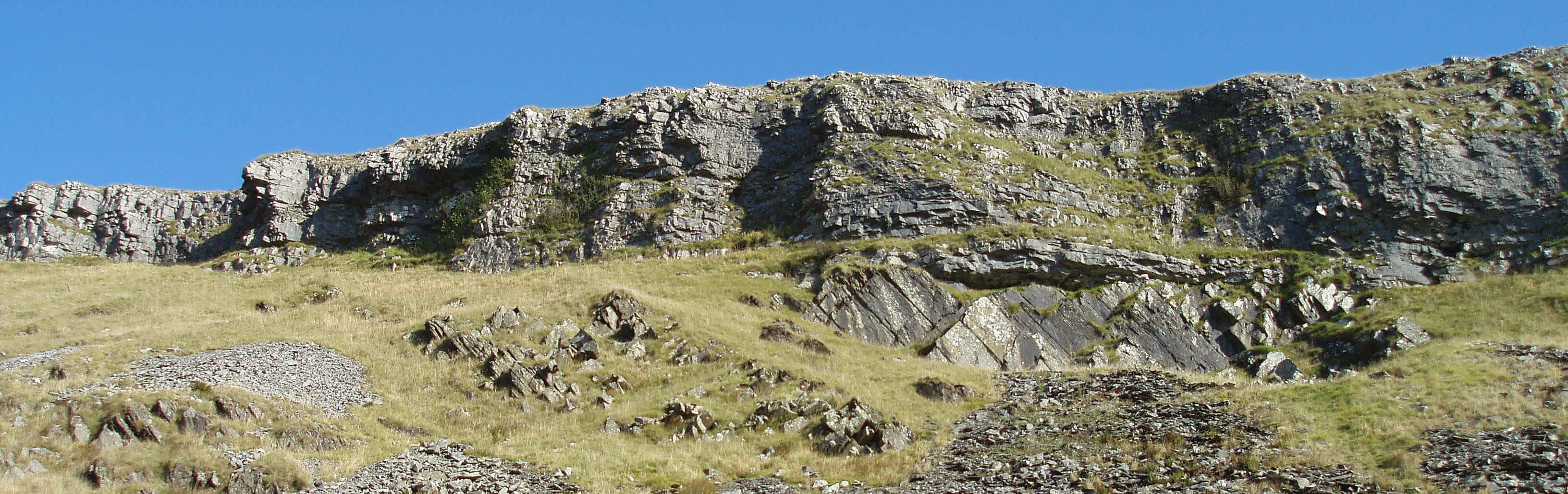
Studrigg Scar
A four-stage process seems likely: the bottom part was laid down; it was then tilted in some enormous upheaval; it was
then eroded so that its surface was horizontal; and then the top part was deposited upon it. All this must have
happened over millions of years. Well, I donÆt know about you but that makes me see the whole of Crummackdale
in a different light. No longer is it just a visually perfect dale but I have a partial understanding, and hence
an enhanced appreciation, of how it came to be how it is. If I had not read about Studrigg Scar then I
suspect that I would have continued to walk right past it. And then, not being distracted by this æsuperficial thingÆ, I could focus on absorbing the spirit of the place.
ThatÆs about as far as we can think by looking at Studrigg Scar from a distance but if we walk up closer we can see that the rocks of the two parts are different. Geologists can name them for us û Carboniferous limestone (top part) and Silurian slate (bottom part). If we look those up in a geology book we will find that thereÆs a 60 million year gap between them.
What happened to the Devonian rocks that should be in between? Again, we donÆt have to be a geologist to think about it. There seem to be only two possibilities: either the Devonian rocks were never formed here or they were formed but were then eroded away before the limestone was deposited. Geologists tell us that the former is the case û that between the Carboniferous and Silurian periods this area was not under the sea.
I walked up past Studrigg Scar, through a convenient (for me, not the farmer) gap in the high wall where it
had fallen or been knocked down (not by me, honest), and on to the top of Moughton (427 metres), with grand views
across to Pen-y-ghent. Back across the dale could be seen the famous
Norber Erratics.
I wonÆt belabour their history now but similar na´ve thoughts could be followed to help us to understand why these huge rocks are scattered there and hence possibly enhance our appreciation of their contribution to the landscape.
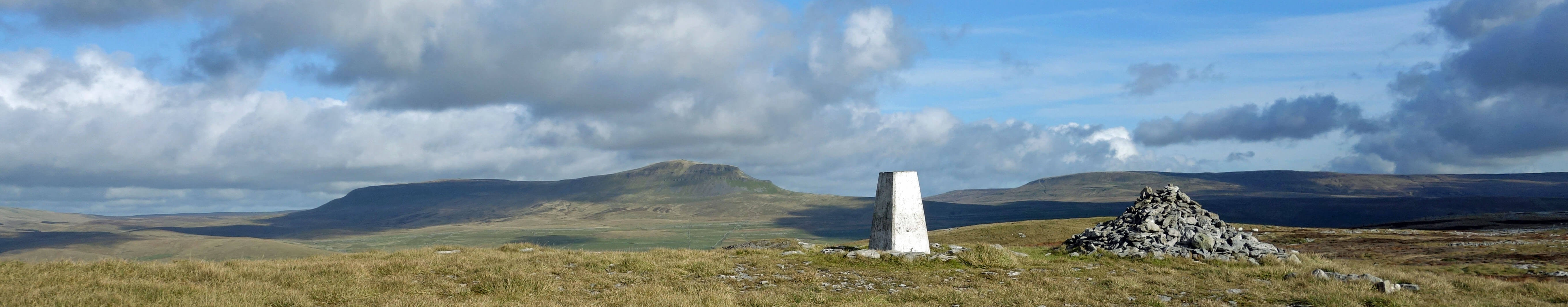
Pen-y-ghent from Moughton
From the trig point I walked north past old grouse butts and stunted juniper towards the footpath that runs between Crummackdale and Horton-in-Ribblesdale. Now, one doesnÆt want to pause too often on a walk asking
oneself questions û but grouse butts? IÆd bet that anyone walking on Moughton will see no grouse. There is little heather for grouse. The butts only make sense if there were grouse here once.
Why have they disappeared? Because sheep have eaten almost all the heather. In fact, a century ago the slopes of Ingleborough were heather-clad, with grouse and butts.
There is no limit to what may be thought interesting (by some) in Crummackdale or anywhere else. There may be rare plants in the limestone grikes, special insects on the juniper, and exotic spiders in the grass. Walkers cannot worry about them all or they would never walk very far.
I continued along the edge of Moughton Scars, a walk that would be even more exhilarating than
it is if you didnÆt have to take care with every step on the fragile limestone pavement. Crummackdale was
spread out below and in direct line beyond there was a distant view of Pendle. From BeggarÆs Stile and
Thieves Moss (more questions), I followed the broad, grassy track past Long Scar and then the ancient
Long Lane to Clapham. Clapham is a village with many attractive features, including a waterfall from the
lake and a couple of neat bridges over Clapham Beck. I particularly appreciate the prim and precise
footpath sign near the war memorial telling me that it is 102 metres to Broken Bridge (although IÆm not sure that the sign is precise in its spelling: itÆs usually written Brokken Bridge). Sometimes it is the superficial things that capture the spirit of a place best.
Ingleborough and Simon Fell from Moughton Scars
Overall, then, my conclusion is that, since knowledge is not all-or-nothing, it is up to everyone to determine the position on the scale that provides the degree of appreciation of the environment and nature that satisfies them.
I will continue to try to enlighten myself û to the benefit of these Saunterings, I hope.
Date: October 16th 2019
Start: SD767683, centre of Austwick (Map: OL2)
Route: (linear) NW, NE, SE over Flascoe Bridge, N û Wharfe û NW, N across fields below Studrigg
û near Hunterstye û E û Moughton û N, W, NW û Thieves Moss û SW û Long Scar û SW, S on Long Lane û W û
Clapham
Distance: 9 miles; Ascent: 280 metres
Home
Preamble
Index
Areas
Map
References
Me
Drakkar
® John Self, Drakkar Press, 2018-

Top photo: The western Howgills from Dillicar;
Bottom photo: Blencathra from Great Mell Fell